Hood County sits southwest of Fort Worth with Granbury at the center of a landscape shaped as much by water and relief as by roads. Lake Granbury occupies a prominent north-central position, the Brazos River continues south and east through a winding valley, and the western half of the county rises into noticeably rougher ground. This page brings those features together with community locations and the main road network. After reviewing the maps, you can download the Hood County Map files as a ZIP containing high-resolution A3 JPG versions of the county, city-connections, terrain-and-water, and elevation maps.
The four views are most useful when they are read as complementary references rather than as interchangeable pictures. The county map is best for orientation around Granbury and the highway network, while the city map strips the layout down to a few nearby communities. The water map makes Lake Granbury, the Brazos River, and named creeks much easier to follow, and the elevation map explains why the western side looks more broken and why the central river corridor occupies lower ground.
Table of Contents
Granbury and the lake-centered settlement pattern
Granbury is the clearest reference point on the county map. Its developed area sits around the southern portion of Lake Granbury, and several nearby communities appear around the same lake system. DeCordova is east of Granbury, Stockton Bend lies to the northeast, and Oak Trail Shores is farther north along the water. Canyon Creek and Pecan Plantation appear to the southeast. Their positions show that settlement in central and eastern Hood County is not arranged along one straight corridor; much of it bends around the reservoir and the roads that cross or skirt the water.
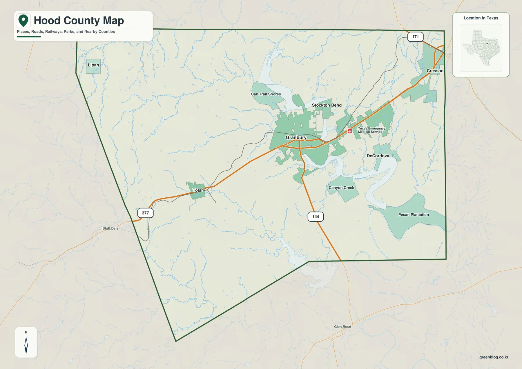
The western side looks different. Tolar is positioned on US 377 southwest of Granbury, while Lipan is close to the northwestern edge of the county. Cresson appears at the northeastern edge near the 171 corridor. These places give the map useful outer reference points: Granbury and the lake dominate the middle, but Hood County extends well beyond the lakeside communities into higher, less densely labeled terrain to the west and toward separate connections at the northeast boundary.
Short lake-side distances and longer western connections
The city-connections map uses Granbury as the hub and highlights how quickly the pattern changes with direction. Stockton Bend is shown about 3 miles from Granbury, DeCordova about 6 miles away, Tolar about 8 miles away, and Lipan about 15 miles away by the map’s direct-distance labels. That makes the contrast easy to see: Stockton Bend and DeCordova belong to the close-in lake area, while Tolar and especially Lipan mark the broader western reach of the county.
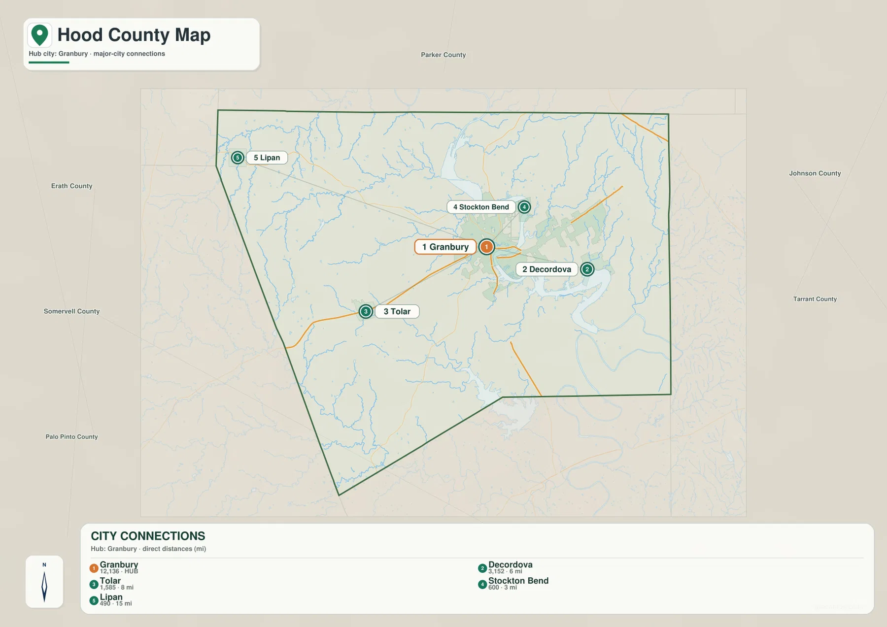
This simplified view is useful when a full road map feels too busy. A reader who only needs to know whether a place is east, west, or northwest of Granbury can find the answer quickly, then switch back to the county map for highway details. It also prevents a common misunderstanding caused by the lake-centered development: communities that look close on a straight-line map may still be separated by water, shoreline curves, or a limited set of road crossings.
US 377, State Highway 144, and the main travel directions
US 377 is the most obvious through route on the county map. It approaches from the southwest through Tolar, crosses Granbury, and continues toward the northeast. State Highway 144 branches south from Granbury, giving the central city a direct route toward the southern part of the county, while State Highway 171 is visible near Cresson in the northeast. Reading these roads first provides a practical framework for locating smaller roads and communities without treating every line on the map as equally important.
The county boundary itself is irregular, especially along the west and southwest sides, so travel directions do not line up with a simple rectangular outline. The city map labels Parker County to the north, Johnson and Tarrant counties to the east, Somervell County to the south, and Palo Pinto and Erath counties to the west. Those labels are helpful when using Hood County as one piece of a larger regional map, because US 377 and other routes continue beyond the county line even though this page focuses on the area inside Hood County.
Lake Granbury and the Brazos River through central Hood County
The terrain-and-water map makes the county’s strongest physical feature unmistakable. Lake Granbury occupies the north-central area, and the Brazos River continues from the lake through the central and eastern parts of the county in a broad series of bends. The water shape is important because it is much wider and more complex than a single river line. Bays, narrow reaches, and curving shorelines create a distinctive middle section that helps explain why nearby development and roads are arranged in arcs rather than in a simple grid.
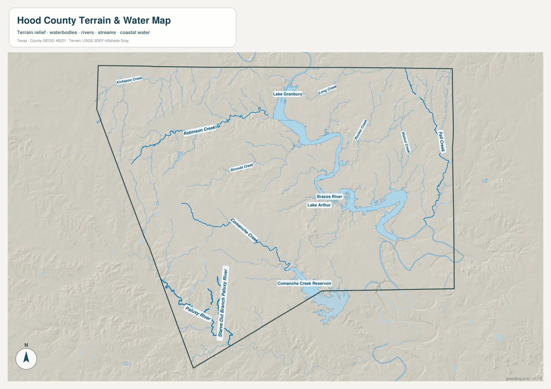
Several smaller waterways add detail to that main system. Robinson Creek enters from the west toward Lake Granbury, while Long Creek is labeled on the northeast side of the lake. Rucker Creek, Walnut Creek, and Fall Creek appear in the east, and Strouds Creek is shown west of the central lake. Farther south, Comanche Creek crosses the county and Comanche Creek Reservoir is labeled near the southern edge. The Paluxy River is also visible near the southwest boundary. Together, these names show that the reservoir and river receive or connect with a much wider network of smaller drainage lines.
For practical map reading, the water map is especially useful when a road or community seems oddly placed on the standard county map. Comparing the same location with the reservoir shoreline or a creek valley often makes the layout more understandable. It is also the better choice for school projects that need named waterways, for identifying communities close to Lake Granbury, or for distinguishing the main Brazos River corridor from smaller creeks that would otherwise be easy to overlook.
Higher western ground and lower river valleys
Hood County has more vertical variation than the standard road map suggests. The elevation map shows an actual range of about 177 to 375 meters, with a mean elevation of roughly 269 meters. The lowest colors follow Lake Granbury and the Brazos River through the middle and eastern side of the county. By contrast, the west and southwest contain much more orange and brown relief, indicating higher ridges and a rougher surface. A second area of higher ground is visible along the northeastern edge.
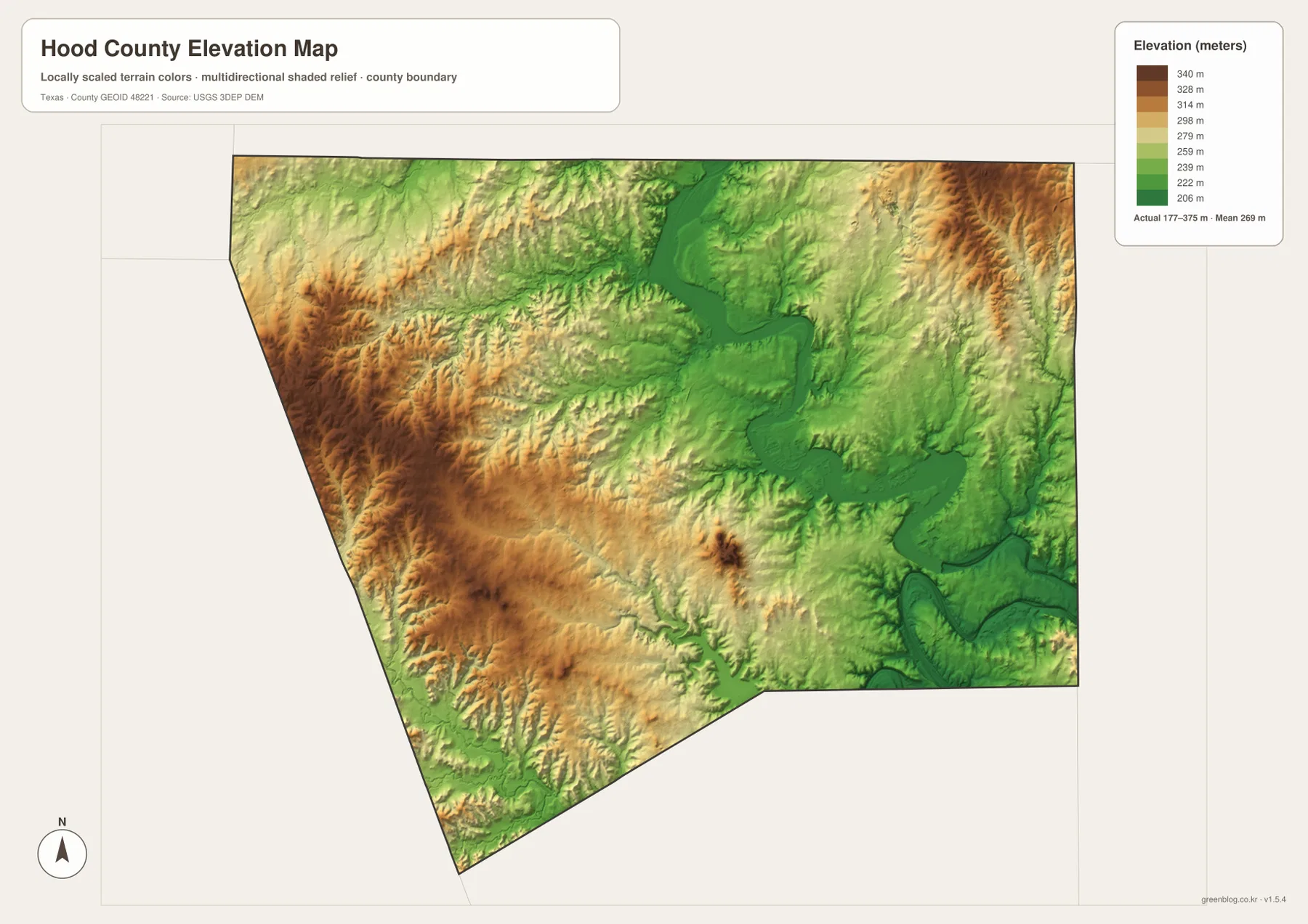
The western relief is not one continuous plateau. Shaded ridges and small valleys create a broken texture from the southwest toward the northwest, while the river and reservoir corridor is smoother and lower. When Tolar and Lipan are compared with Granbury and DeCordova across the different maps, the topographic contrast becomes easier to understand. The towns are not simply separated by distance; they occupy parts of the county with different combinations of water, hills, and road access.
Elevation does not tell the reader anything about property ownership or whether land can be developed, but it is valuable background for understanding the physical map. Roads may bend around steeper ground, creeks collect in lower valleys, and the broad river corridor stands out more clearly when the elevation layer is viewed beside the water map. For any engineering, flood, or property decision, readers should still use the appropriate official datasets rather than treating this overview map as a regulatory source.
Tolar, Lipan, DeCordova, and the smaller communities
Granbury receives the most visual attention because it is the county seat and sits near the largest concentration of mapped development, but the surrounding names add important geographic context. Tolar provides a western point along US 377, and Lipan anchors the northwest. DeCordova sits close to the reservoir east of Granbury, while Stockton Bend and Oak Trail Shores represent the north side of the lake. Canyon Creek and Pecan Plantation show how settlement continues around the southern and southeastern water edges.
This spread matters when the map is used for local orientation. A destination near DeCordova may be only a short straight-line distance from central Granbury but still depends on the shape of the lake and the available road approach. A trip toward Tolar or Lipan is different because it leaves the lakeside concentration and moves into the higher western part of the county. Cresson, meanwhile, points toward the northeastern connection rather than the US 377 route through Tolar. The map becomes more useful when those differences are treated as separate directions instead of as a generic list of towns.
Choosing the map that fits the task
Use the county map when you need the broadest combination of boundaries, communities, roads, and water in one view. It is the best starting point for locating Granbury relative to Tolar, Lipan, Cresson, or the lake-side communities. The city-connections map is more focused and works well when direction and relative distance from Granbury matter more than minor roads. It is also easier to use in a presentation where too many labels would distract from a simple community comparison.
Choose the terrain-and-water map when Lake Granbury, the Brazos River, named creeks, and local relief are the main subject. Its stronger water styling makes tributaries such as Robinson Creek, Rucker Creek, and Comanche Creek easier to trace. The elevation map is the best companion when the question concerns high and low ground. It makes the contrast between the western hills and the lower central river corridor much more obvious than the general map.
The download ZIP contains the four high-resolution JPG maps represented in this article. The WebP previews are convenient for quick viewing in the browser, while the larger JPG files are better suited to printing or inserting into a document. Because each file emphasizes a different type of information, readers can use one map on its own or place two maps side by side to compare the same Hood County location across roads, water, and elevation.
A practical reading order for the Hood County maps
For a first visit, begin with Granbury and Lake Granbury. Next, trace US 377 from Tolar through Granbury toward the northeast and locate the southbound 144 route. Once those anchors are clear, add DeCordova and Stockton Bend on the lake side, then look farther out to Lipan and Cresson. That order gives the county a recognizable shape before smaller streams and terrain details are introduced.
If the purpose is physical geography, reverse the process. Start with Lake Granbury and the Brazos River on the water map, follow Robinson Creek, Long Creek, Rucker Creek, Comanche Creek, and the other labeled tributaries, and then switch to the elevation map. The river-and-reservoir system aligns with much of the lower green terrain, while the western side rises into stronger relief. The two maps together make a clear connection between waterways and the county’s high-low pattern without requiring specialized GIS software.
For printed classroom material, the maps can be assigned separate jobs. Students can mark communities and highways on the county map, compare Granbury-to-community directions on the city map, label the water system on the terrain map, and identify higher versus lower areas on the elevation map. For personal reference or trip planning, a similar sequence works: locate the destination, check the road approach, note any nearby lake or river feature, and use elevation only when the shape of the terrain is relevant.
Frequently Asked Questions
What is the best place to start on a Hood County map?
Granbury is the easiest anchor because it sits near Lake Granbury and connects directly with US 377 and State Highway 144. From there, DeCordova and Stockton Bend can be located around the lake, while Tolar and Lipan provide clear reference points for the western side of the county.
How are Lake Granbury and the Brazos River shown on the map?
Lake Granbury appears as the broad north-central reservoir, and the Brazos River continues southward from it before bending through the central and eastern part of Hood County. Reading the two together makes the county’s main water corridor much easier to follow.
Where is Hood County highest and lowest on the provided elevation map?
The map shows an approximate range from 177 to 375 meters. Lower ground follows Lake Granbury and the Brazos River through the central and eastern county, while much of the west and parts of the northeastern edge rise to higher elevations.
Map File Information
Download the Hood County county map, city-connections map, terrain-and-water map, and elevation map together as high-resolution A3 JPG files. The ZIP is useful for printing, classroom work, trip planning, local reference, and side-by-side comparison.
- File Type: JPG
Related Maps
- Parker County Texas map
- Somervell County
- Palo Pinto County Texas map
- Tarrant County Texas map
- Shackelford County Texas map
Sources and References
For additional official geographic data, see the U.S. Census Bureau TIGER/Line Shapefiles for boundary and road layers, USGS National Hydrography for rivers and water features, and the USGS 3D Elevation Program for elevation data. The USGS The National Map Viewer is also useful when several geographic layers need to be checked together.
Green Map creates custom-edited map images using open geographic data sources such as geoBoundaries, Natural Earth, OpenStreetMap, and government open data.
These maps are edited visual materials, not raw data files, and are provided for education, documents, presentations, and graphic reference.