Anderson County in East Tennessee is easiest to understand when Clinton, Oak Ridge, Norris, and Rocky Top are viewed together rather than as isolated place names. Clinton is the county seat, Oak Ridge forms the major urban reference in the south, and the northern communities sit closer to I-75 and the large reservoir waters near Norris. This page separates those relationships into a county reference map, a city-connections map, a terrain-and-water map, and an elevation map. High-resolution A3 JPG versions are also available to download for printing, classroom work, presentations, or local reference.
The county has a strong contrast between water, ridges, and settlement. Large reservoir arms cut into the northern edge, a dense network of creeks follows valleys through the interior, and the western side rises much higher than the eastern half. Roads and towns therefore do not form a simple grid. The four maps are most useful when they are read as complementary views: one establishes the county outline and roads, another simplifies town-to-town position, a third concentrates on streams and water, and the last shows how sharply elevation changes from west to east.
Table of Contents
Start with Clinton, Oak Ridge, and the county outline
The county reference map places Clinton near the middle of Anderson County and marks the Anderson County Courthouse, making the administrative center easy to identify. Oak Ridge occupies the broad southern section, while Oliver Springs lies to the west of it. Farther north, Rocky Top and Norris provide useful anchors near the reservoir and the I-75 side of the county. Briceville and Andersonville add smaller local references, so the map does more than connect the seat to one large city. It shows how settlement is spread through several valleys and road corridors.
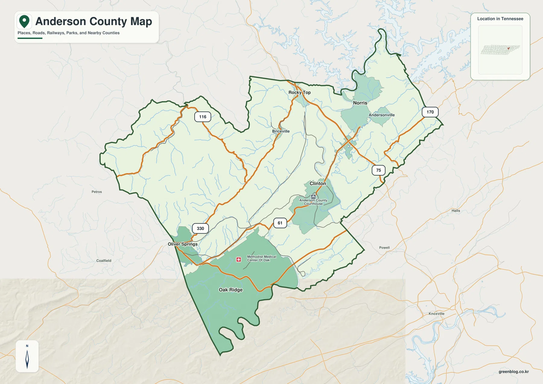
I-75 runs along the eastern side and gives the county its clearest north-south regional highway connection. State Route 61 crosses Clinton and continues toward the southwest, while Route 116 reaches into the more mountainous western side. Route 330 appears near Oliver Springs and Route 170 is shown in the northeast. The map does not try to label every local street or interchange. Instead, it keeps the routes that are most helpful for understanding how the main communities connect to the county boundary and to surrounding East Tennessee.
Anderson County borders Campbell, Union, Knox, Roane, Morgan, and Scott counties. The reference map also shows outside places such as Halls, Powell, and Knoxville, which are useful for orientation without implying that they lie inside Anderson County. This is especially helpful around Oak Ridge, where the southern county line sits close to other county jurisdictions, and around Rocky Top, where the northern boundary is nearby. When copying labels into another project, tracing the county outline first prevents a nearby place from being assigned to the wrong county.
| County fact | Value used on this page |
|---|---|
| County seat | Clinton |
| 2020 Census population | 77,123 |
| July 2025 population estimate | 82,066 |
| Land area | 337.2 sq mi |
| Water area | 7.6 sq mi |
| FIPS code | 47001 |
| Elevation map actual range | 207–1,073 m; mean 394 m |
The 2020 census counted 77,123 residents, while the Census Bureau’s July 2025 estimate shown in the source material is 82,066. Those figures should not be treated as two identical measurements because one is a decennial census count and the other is an estimate. Gazetteer figures give 337.2 square miles of land compared with 7.6 square miles of water. Those totals describe the county as a whole, but the maps show why population and development are not likely to be spread evenly across the high western terrain, the Oak Ridge urban area, the Clinton area, and the reservoir valleys.
Oak Ridge works well as a hub for comparing nearby towns
The city-connections map strips away much of the background detail and uses Oak Ridge as the hub. That makes the relative positions of Clinton, Oliver Springs, Rocky Top, and Norris immediately clear. Oliver Springs sits close to Oak Ridge on the west side, Clinton is northeast of the hub, and Rocky Top and Norris are farther north. Because the map also prints direct distances, it is useful for readers who want a quick sense of scale before they look at the road network in more detail.
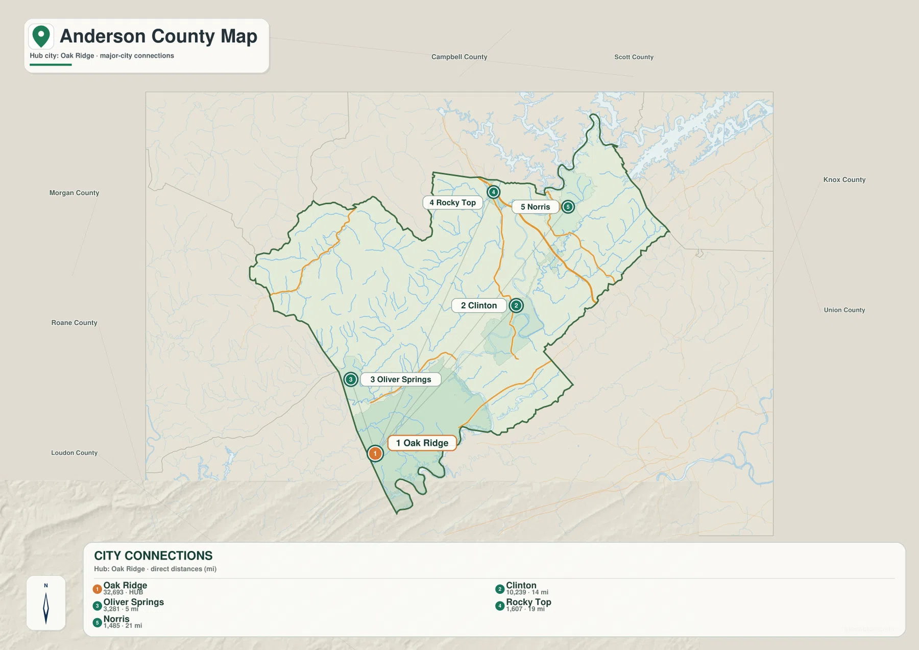
The direct-distance labels are about 5 miles from Oak Ridge to Oliver Springs, 14 miles to Clinton, 19 miles to Rocky Top, and 21 miles to Norris. These are straight-line distances, not driving distances. That distinction matters in Anderson County because ridges, rivers, reservoir arms, and limited crossings can make a road trip longer than a simple line on the map suggests. The city map is therefore best for comparing location and scale, while the county map or a current navigation service is better for following an actual route.
This view also makes an important local distinction visible: the county seat and the largest urban reference are not the same place. Clinton represents county government, while Oak Ridge is the major southern population and employment center shown on the map. Norris and Rocky Top belong to a different northern setting near the reservoir and interstate corridor. Looking at all of them together keeps Anderson County from being reduced to a single city and gives a more realistic picture of how its communities are distributed.
Reservoir arms and creeks shape the county from north to south
The terrain-and-water map reveals a much denser drainage network than the general county map. Broad reservoir water reaches into the northern edge, while streams and forks spread through the interior valleys. Anderson County is closely associated with the Clinch River and Norris Dam system, but the map is useful precisely because it does not stop with one famous water feature. It shows the smaller creeks that occupy different parts of the county and helps explain why roads and settlement often follow low ground instead of crossing the landscape in straight lines.
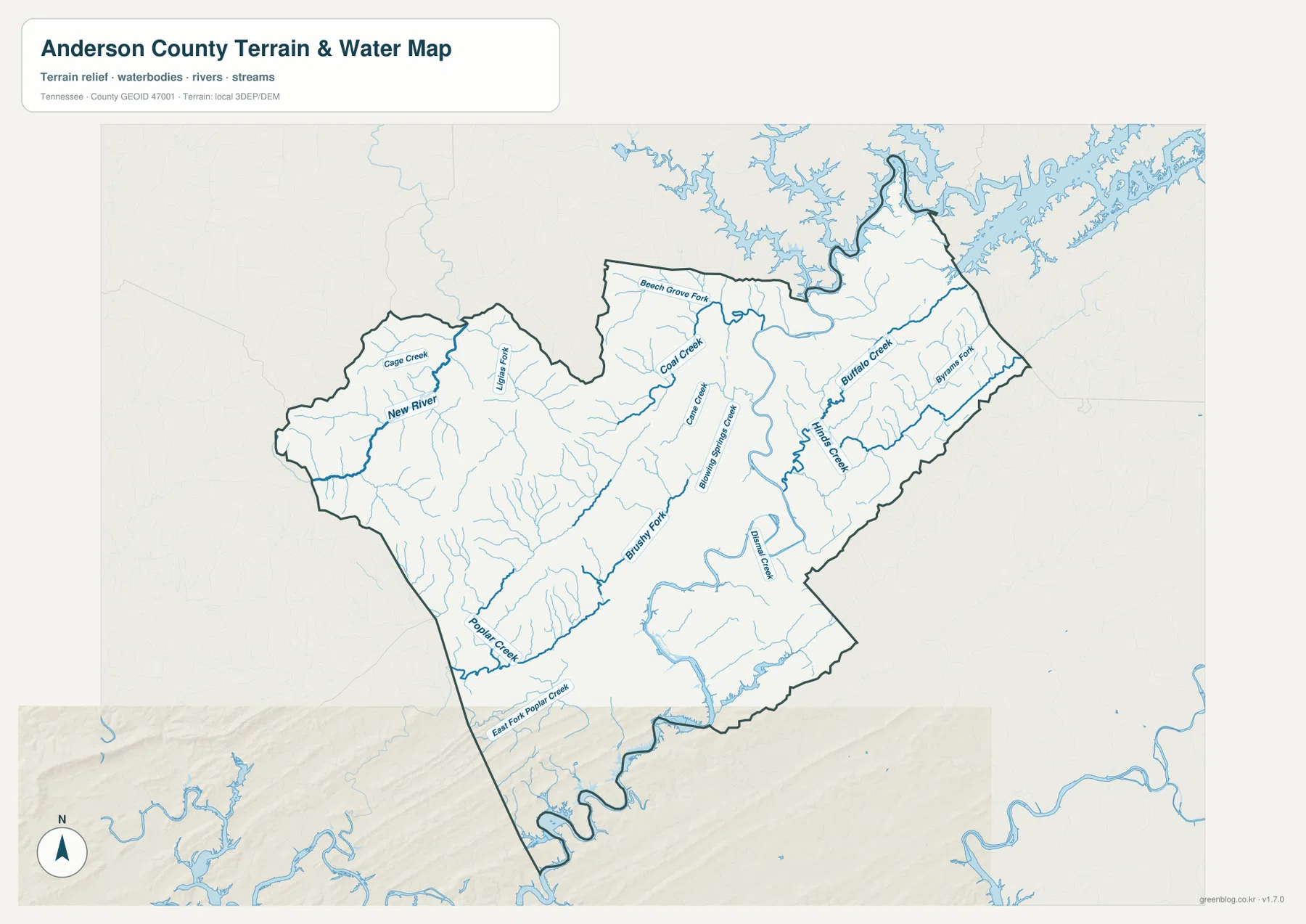
New River is one of the most prominent named channels on the western side. Coal Creek and Cane Creek appear through the central and northern interior, while Buffalo Creek runs through the eastern side. Farther south, Poplar Creek and East Fork Poplar Creek are useful references near the Oak Ridge portion of the county, and Brushy Fork appears among the western drainage lines. Smaller tributaries fill the spaces between those names. The result is a county where the water network follows the valleys closely and changes character from the rugged west to the lower eastern ridges.
Only 7.6 square miles of the county are listed as water in the Gazetteer area figures, yet water can still have an outsized effect on movement. A long reservoir arm may require a bridge or a substantial detour, and a creek valley may provide the easiest path through higher ground. The water map is not a live flood, boating, or navigation chart, so it should not be used to judge current water level or safe access. Its value is geographic: it shows where the named channels are and how they fit the county’s broader terrain.
The west side rises sharply above the eastern ridges
The elevation map gives Anderson County its clearest physical contrast. The legend reports an actual range of roughly 207 to 1,073 meters and a mean elevation of 394 meters. High terrain is concentrated in the west and northwest, where brown and light tones mark steep ridges and closely spaced valleys. The eastern half is predominantly green, meaning lower elevation overall, but it is not flat. Long, narrow ridges still run across that side of the county and create the familiar ridge-and-valley texture of East Tennessee.
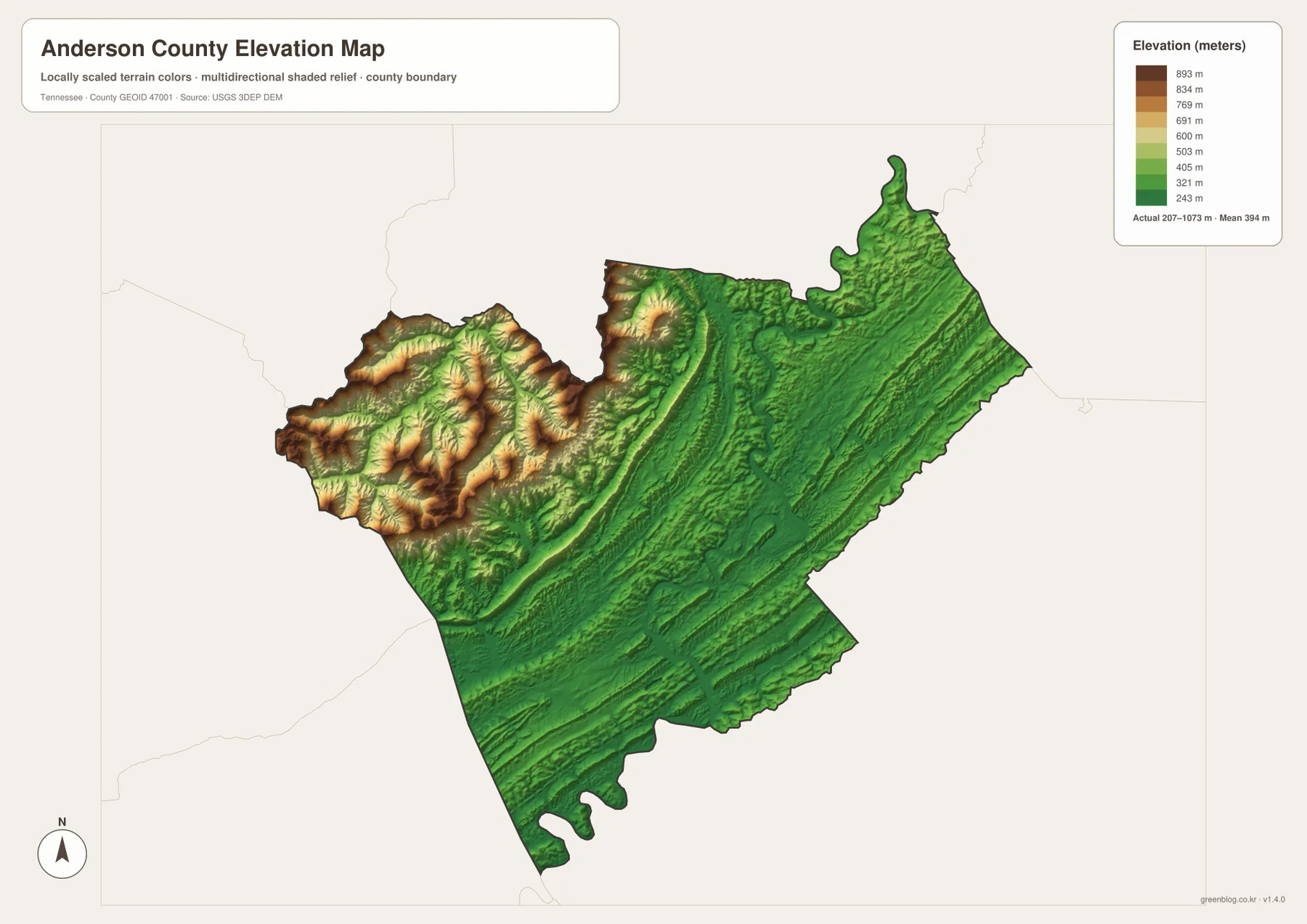
Route 116 passes through the western side where the relief is strongest, so its surroundings look very different from the I-75 side of the county. Moving eastward, the overall elevation drops, but parallel ridges and valleys remain visible in the shaded relief. That pattern helps explain why both roads and streams often run along the same general northeast-southwest grain. A place can be close in straight-line distance yet require a less direct road connection when a high ridge lies between two valleys.
The elevation colors should be used for county-scale comparison rather than for estimating the height of a particular building, trail, or summit. The map is strongest when paired with the other layers. The city map shows where the communities are, the water map shows the valley drainage, and the elevation map shows which parts of the county are likely to be more rugged. Together they make the difference between the Oak Ridge–Clinton side and the western mountain area much easier to see.
Roads make more sense when boundaries, water, and terrain stay visible
On a road-only map, I-75 can look like the dominant organizing feature of Anderson County. It is certainly important, especially for travel toward Rocky Top and the eastern edge, but it serves only one part of the county. State Route 61 links Clinton with the southwest, Route 116 reaches into the rugged west, and other state routes connect smaller communities. Once the elevation and water maps are considered, the different route shapes become easier to understand: valleys provide natural passages, high ridges interrupt direct travel, and reservoir water limits where crossings can occur.
Boundary awareness is equally important. Rocky Top lies close to the northern county line, while Oak Ridge fills a southern section where other county jurisdictions are nearby. Knoxville, Powell, and Halls appear outside the outline as regional orientation points. For classroom maps, editorial graphics, or local planning notes, a reliable workflow is to keep the county boundary visible first and then add the towns, roads, and water features that matter to the project. This avoids treating every nearby label as if it were inside Anderson County.
Anderson County was established in 1801, and Clinton remains the county seat. That historic administrative pattern now sits alongside a modern geography shaped by Oak Ridge, I-75, Norris Dam, reservoir recreation, and the mountain-and-valley terrain. The map set is useful because it separates those subjects instead of forcing every historical, transportation, water, and elevation detail into one crowded image. Readers can start with the question they need to answer and then move to the map that contains the clearest evidence.
Choose the map that matches the question
Use the county reference map when you need the outline, the main communities, major roads, and nearby regional context on one page. Use the city-connections map when the main question is where Oak Ridge, Clinton, Oliver Springs, Rocky Top, and Norris sit in relation to one another. The water map is better for named creeks and the reservoir-influenced drainage network, while the elevation map is the clearest choice for comparing the high western terrain with the lower eastern ridges. Two maps can also be placed side by side when the relationship between subjects matters more than a single layer by itself.
For a school project or presentation, the county map can serve as the clean overview and the water or elevation map can be added as supporting evidence. For trip planning, the maps are good for establishing county-scale orientation before opening a current road service for turn-by-turn directions. For property or land research, they can show the surrounding county, terrain, and nearby water network, but they do not replace parcel records, surveys, access agreements, or current agency information.
If you plan to annotate the maps, keep one clean copy and work on a duplicate. The county map is the best base for adding route or location notes, the water map helps when a project needs named streams, and the elevation map gives immediate visual separation between high and low terrain. There is no need to use all four files in every project. Selecting only the layer that supports the task usually produces a clearer final graphic.
Frequently Asked Questions
Why are Clinton and Oak Ridge both important on an Anderson County map?
Clinton is the county seat, so it identifies the administrative center. Oak Ridge is the major southern urban reference and gives a different picture of where people, roads, and services are concentrated. Adding Norris, Rocky Top, and Oliver Springs makes the internal geography clearer because the county is not organized around one single town.
What should I look for on the Anderson County water map?
Start with the broad reservoir water along the north and then follow the named channels through the interior. New River stands out in the west, Coal Creek and Cane Creek appear in the central and northern area, Buffalo Creek is on the east side, and Poplar Creek and East Fork Poplar Creek help orient the southern part of the county. Comparing those streams with roads and towns shows how strongly valleys guide the local map.
How should I use the 207–1,073 meter elevation range?
Use it to compare broad parts of the county rather than to estimate a specific summit or property elevation. The western and northwestern terrain is much higher and more rugged, while the eastern half is generally lower but still contains long ridges and valleys. Pairing the elevation map with the city or road map is a simple way to see why some short straight-line distances can involve less direct travel.
Map File Information
The download ZIP contains four high-resolution A3 JPG files for Anderson County: the county reference map, city-connections map, terrain-and-water map, and elevation map. The WebP images in the article are lightweight previews; use the JPG files when you need better quality for printing or editing.
- Included Files: County map, city map, water map, elevation map
- File Type: JPG
Related Maps
Sources and Data References
The links below provide official or primary references for Anderson County history, roads, population, boundaries, hydrography, and elevation. They are useful when a project requires a current figure or a more detailed source than the static maps on this page.
- Tennessee State Library and Archives – Anderson County fact sheet
- Tennessee Department of Transportation – Anderson County road reference
- U.S. Census Bureau QuickFacts – Anderson County, Tennessee
- U.S. Census Bureau TIGER/Line boundary files
- USGS National Hydrography
- USGS 3D Elevation Program
Green Map creates custom-edited map images using open geographic data sources such as geoBoundaries, Natural Earth, OpenStreetMap, and government open data. These maps are edited visual materials, not raw data files, and are provided for education, documents, presentations, and graphic reference.