Harrison County combines one of Mississippi’s most urbanized coastal strips with a much quieter inland landscape. Gulfport and Biloxi dominate the southern half of the map, while Long Beach, Pass Christian, D’Iberville, and Saucier help show how settlement changes from the shoreline to the wooded interior. The maps on this page let you compare county boundaries, major roads, ranked cities, rivers and coastal water, and elevation without treating those features as separate subjects.
The page uses WebP previews for quick viewing, but the download box provides the current county, city, water, and elevation maps as high-resolution A3 JPG files in one ZIP archive. A useful way to begin is to locate Gulfport and Biloxi, then compare the water and elevation maps to see why the low coast looks so different from the ridged northern part of the county.
Table of Contents
Start with the Gulfport-Biloxi coast and work inland
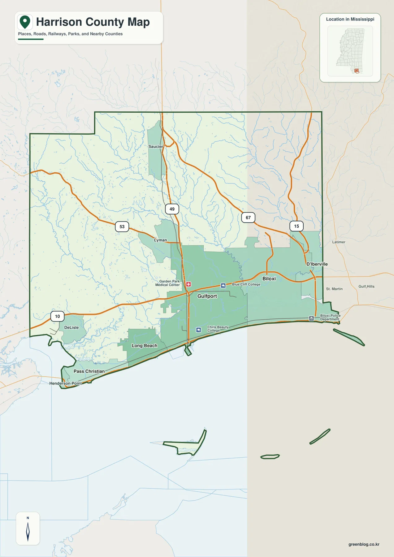
The county reference map makes the southern concentration of roads and places easy to see. Gulfport sits near the middle of the developed shoreline, with Biloxi farther east. Long Beach and Pass Christian extend the sequence westward, while D’Iberville lies just north of Biloxi across the Back Bay area. Saucier is well inland and provides a useful northern reference when comparing the coast with the rest of Harrison County.
I-10 runs east-west through the southern part of the county and ties the coastal communities to the wider Gulf Coast corridor. US 49 heads north from Gulfport toward Saucier, making it the clearest north-south route on the map. State routes 53, 67, and 15 add other connections through the interior. The map is not designed to replace a city street map, but it works well for understanding which communities sit on the coast, which lie inland, and how the major routes connect them.
The city index shows how strongly population is concentrated near the coast
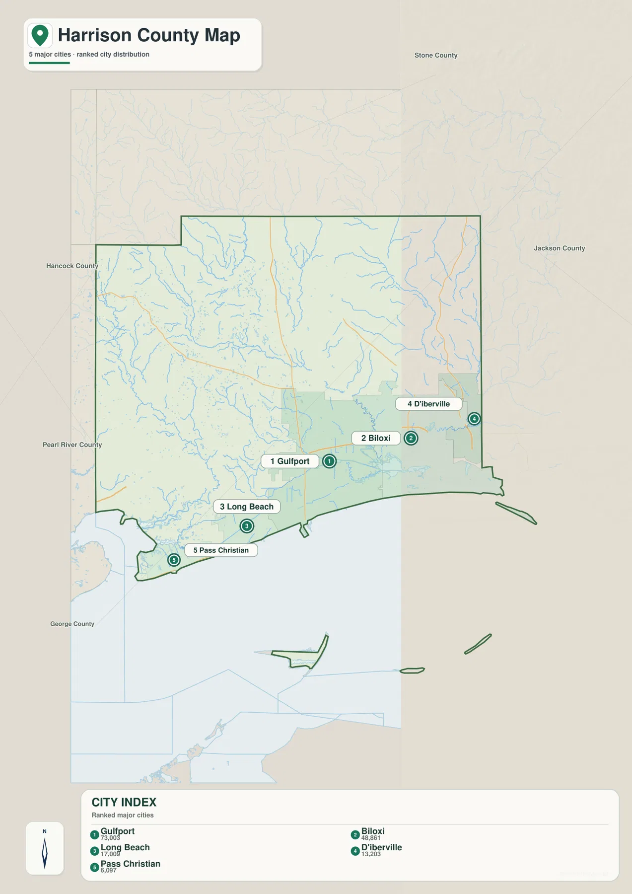
The city map ranks five major cities shown in the package. Gulfport is listed first at 73,003, followed by Biloxi at 48,861. Long Beach is shown at 17,009, D’Iberville at 13,203, and Pass Christian at 6,097. These figures are the values printed in the city index on the supplied map, so they are best used to understand the map’s city ranking rather than as a substitute for the latest municipal population release.
The locations themselves are just as informative as the numbers. Gulfport and Biloxi form two large centers along the shoreline, with Long Beach and Pass Christian continuing west. D’Iberville sits north of the immediate beach line and is separated from Biloxi by water and road crossings. By contrast, the northern half of the county has no similarly ranked city on this map. That visual difference helps explain why a county-wide average can hide a very uneven settlement pattern.
Rivers converge toward Mississippi Sound and Biloxi Bay
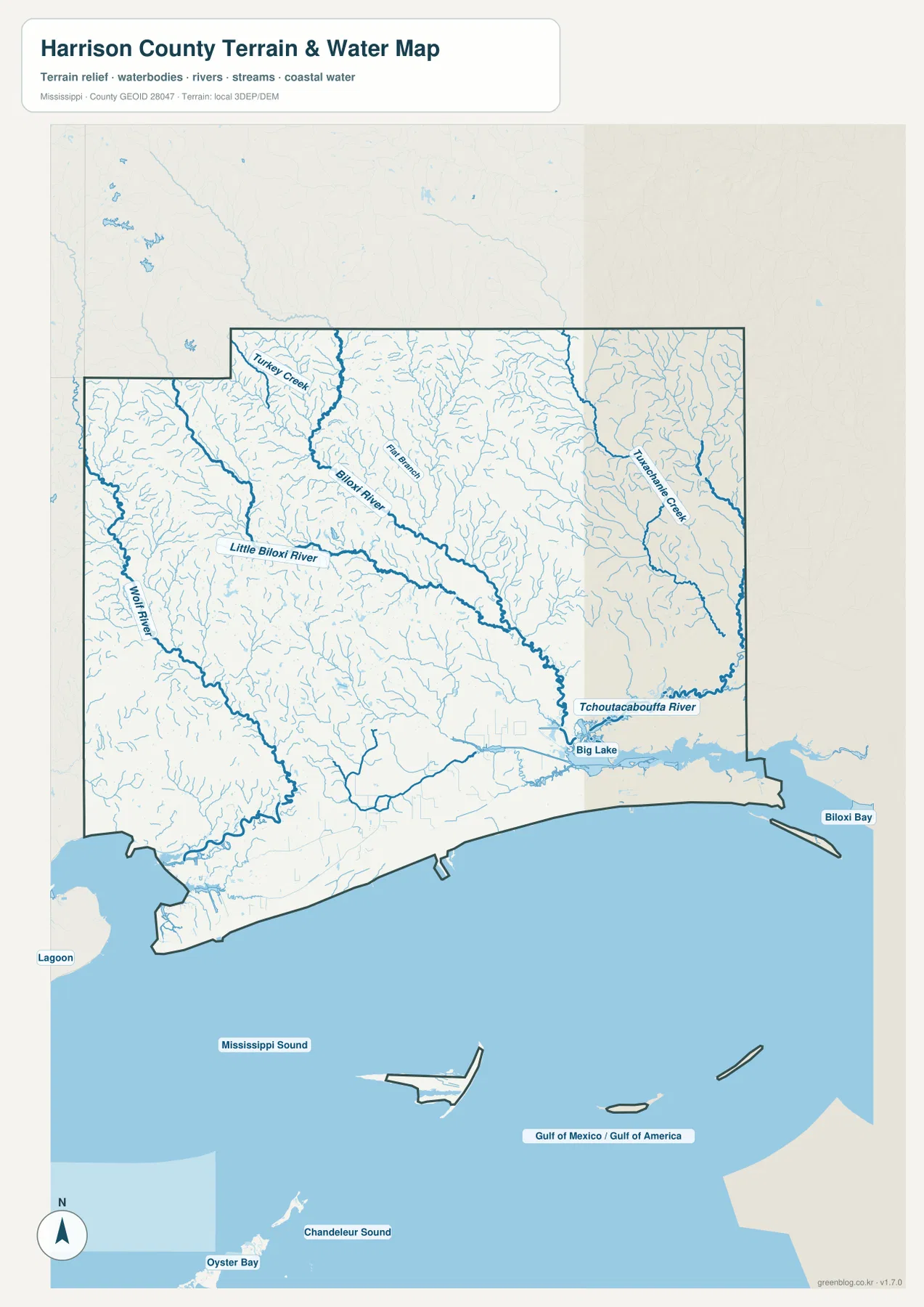
The water map adds a layer that the road map cannot show. Wolf River follows the western side of the county, while Little Biloxi River and Biloxi River drain a broad central area through a dense network of smaller branches. Farther east, Tuxachanie Creek runs southward, and the Tchoutacabouffa River bends toward the Biloxi area. Big Lake is labeled near the lower Tchoutacabouffa system, close to the transition from inland water to the coastal bays.
South of the mainland, Mississippi Sound occupies a large part of the mapped county area. Biloxi Bay appears on the eastern coast, and the lower map also labels Chandeleur Sound and the Gulf of Mexico / Gulf of America. Several detached island-shaped parts of the county are visible offshore. Those features matter because Harrison County is not simply a block of land bordered by water; a substantial portion of its mapped area extends into the coastal water and island zone.
Elevation rises away from the low coast
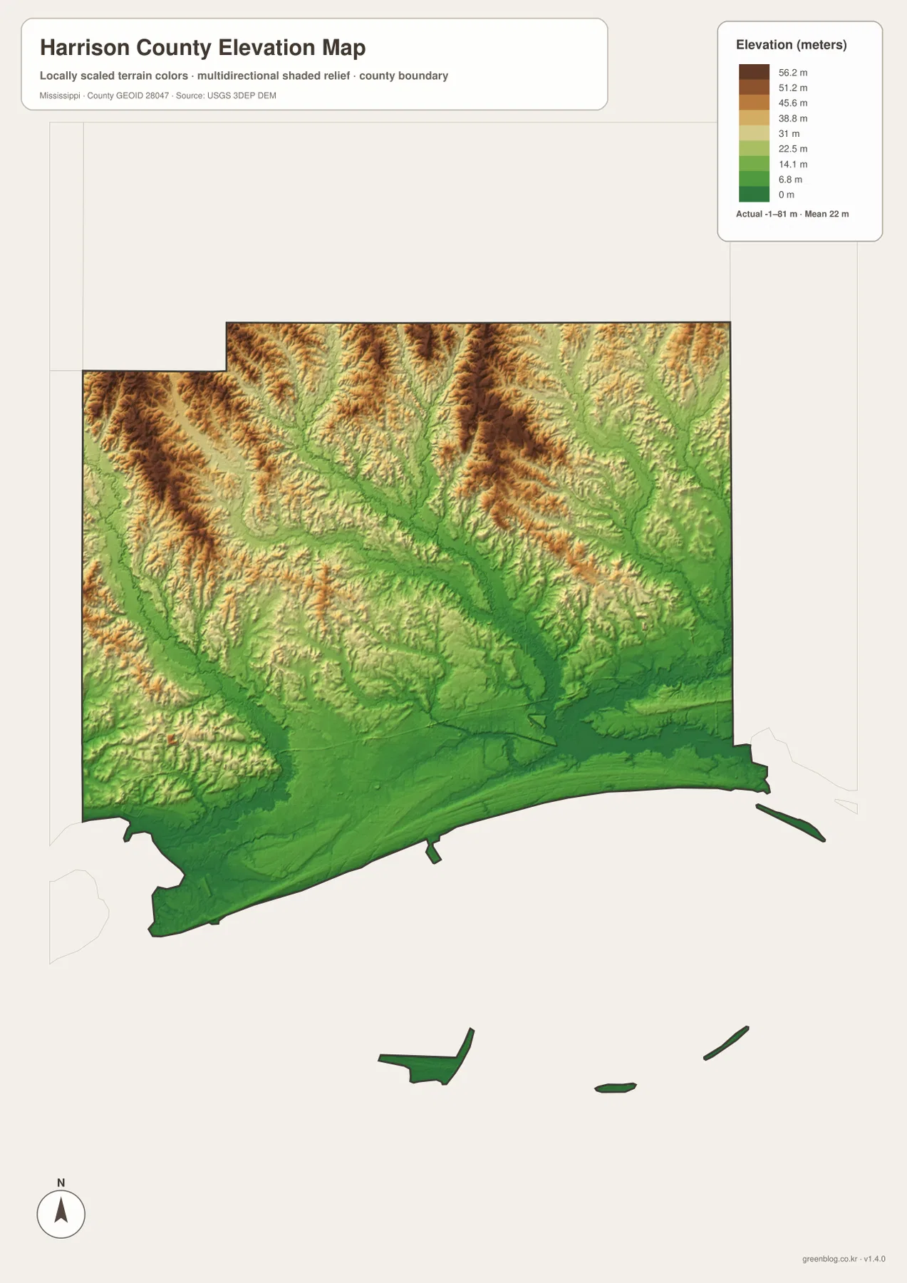
The elevation map gives Harrison County an actual range of about -1 to 81 meters, with a mean of 22 meters. The shoreline and the broad lower river corridors are shown in the lowest green tones. Moving north, especially into the northwestern and north-central parts of the county, the colors shift toward tan and brown as narrow ridges become more common.
This is not mountainous terrain, but the contrast is important. River valleys cut long low paths through the interior, while the land between them rises into small ridges and rolling uplands. The Biloxi River and Little Biloxi River valleys are especially easy to match between the water map and the relief map. Comparing those two maps makes it clear that many of the lower areas are connected to stream corridors rather than being randomly scattered across the county.
Population and area make more sense after looking at the shoreline
- FIPS code: 28047
- County-seat centers: Gulfport and Biloxi
- 2020 Census population: 208,621
- July 2025 population estimate: 217,136
- 2025 Gazetteer land area: 573.650 square miles
- 2025 Gazetteer water area: 411.039 square miles
The water figure is unusually large relative to the land figure, which is much easier to understand once Mississippi Sound, the bays, and the offshore county pieces are visible on the map. Using the 2020 Census population and the 2025 Gazetteer land area gives about 363.7 residents per square mile. That number is a county-wide calculation, not a description of how people are distributed. The city map shows why: the largest population centers are concentrated along the southern coast, while broad inland sections have far fewer major city labels.
Choose the map that matches the question
For a quick orientation, use the county map to locate Gulfport, Biloxi, Saucier, the main highways, and the county boundary. Use the city map when relative city size and the coastal settlement pattern matter. The water map is the best choice for tracing the Biloxi River system, Wolf River, Tchoutacabouffa River, bays, and Mississippi Sound. The elevation map answers a different question by showing where the low coastal plain gives way to higher inland ridges.
If you need a larger file for print, classroom work, presentations, or offline reference, the ZIP below contains the current county, city, water, and elevation maps as high-resolution A3 JPG files. The WebP images on the page are convenient for browsing, while the JPG versions retain the larger dimensions intended for downloading and reuse.
Frequently Asked Questions
Why are both Gulfport and Biloxi important county references?
The source material for this package identifies Gulfport and Biloxi as the county-seat centers. They also occupy separate positions along the coast, so keeping both in view makes it easier to understand the county’s southern urban pattern.
Why does Harrison County have so much mapped water area?
The county extends into Mississippi Sound and includes offshore pieces as well as bays and shoreline water. The 2025 Gazetteer figures in the supplied material list 411.039 square miles of water compared with 573.650 square miles of land.
How much higher is the inland part of the county than the coast?
The elevation map spans about -1 to 81 meters with a mean of 22 meters. The immediate coast and lower river corridors occupy the lowest range, while the northern interior contains many of the higher ridges.
Sources and Reference Data
- U.S. Census Bureau QuickFacts – Harrison County
- U.S. Census Bureau Gazetteer Files
- Mississippi Department of Transportation official highway map
- USGS National Hydrography
- USGS 3D Elevation Program
- National Park Service – Gulf Islands National Seashore
Map File Information
This ZIP contains the Harrison County county, city, water, and elevation maps as high-resolution A3 JPG files.
- Included Files: County map, city map, water map, elevation map
Related Maps
Green Map creates custom-edited map images using open geographic data sources such as geoBoundaries, Natural Earth, OpenStreetMap, and government open data. These maps are edited visual materials, not raw data files, and are provided for education, documents, presentations, and graphic reference.