You can download the Broward County Map files from this page as one ZIP containing three high-resolution JPG maps. The set shows the full county with major roads, the locations of six major cities, and the Atlantic coast with rivers, canals, lakes, and other named waters. On the map, Fort Lauderdale, Hollywood, and Pompano Beach sit within the dense eastern urban band, while Pembroke Pines, Miramar, Coral Springs, Sunrise, and Weston extend development farther inland before the county opens into the western Everglades conservation area.
That sharp east-west change is the key to understanding Broward. Most municipalities and major roads occupy the eastern and central part of the county, but the official boundary continues far west across broad wetland and water-management lands. Looking first at cities and roads, then at the water map, makes it easier to see why a heavily built metropolitan county can also contain such a large undeveloped western area.
Table of Contents
A county boundary that stretches far beyond the urban belt
Broward County sits in southeastern Florida between Palm Beach County on the north and Miami-Dade County on the south. The Atlantic Ocean forms its eastern side, while the county boundary extends west toward Everglades country adjoining the Collier and Hendry side of South Florida. Census material used in the source package lists 1,202.73 square miles of land and a July 1, 2025 population estimate of 2,013,317. Broward County Planning Council material adds an important qualification: population is strongly concentrated in roughly 431 square miles east of the County’s Conservation Area. That distinction between total land area and developed land is one of the most useful facts for reading the map.
The county map makes the difference visible without requiring a separate land-use layer. Parkland, Deerfield Beach, Coral Springs, Pompano Beach, Sunrise, Plantation, Fort Lauderdale, Weston, Davie, Southwest Ranches, Pembroke Pines, Hollywood, and Miramar all appear in the eastern or central portion. Farther west, labels become sparse even though the county boundary continues for many miles. The apparent blank space is not an omitted group of cities. It represents the transition from metropolitan South Florida to a water-conservation landscape associated with the Everglades.
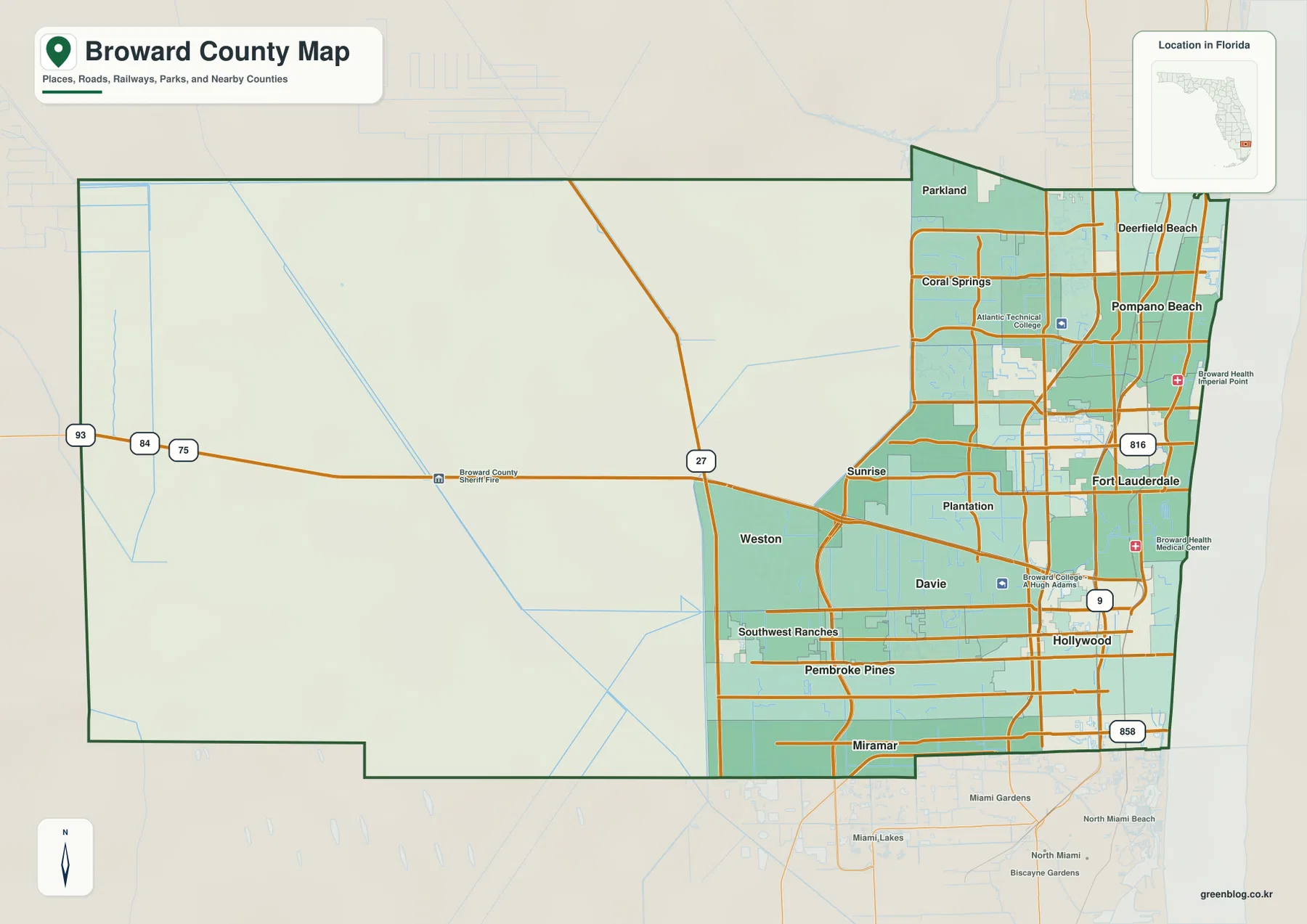
Fort Lauderdale is the county seat and an important geographic reference, but the map does not show a county organized around a single center. Hollywood and Pompano Beach form large eastern centers to the south and north, while Pembroke Pines, Miramar, Coral Springs, and Weston occupy major positions farther inland. That spread is why a map focused only on Fort Lauderdale would miss much of Broward’s urban geography. The county is better read as a connected group of cities occupying the eastern part of a much larger administrative territory.
I-95, I-595, and the roads that tie Broward together
I-95 is a practical first reference for the eastern side of the county. It runs north-south just inland from the Atlantic and serves the corridor containing Deerfield Beach, Pompano Beach, Fort Lauderdale, and Hollywood. Florida’s Turnpike provides another north-south route farther west, while US 1 runs closer to the long-established coastal cities. A1A is farther east again, following the beach and barrier-island side. These parallel routes help distinguish Broward’s beachfront communities from the inner coastal city belt and the larger freeway network.
I-595 is different because it crosses the county from east to west. Source material in the package describes its connections with Florida’s Turnpike, US 441, University Drive, Flamingo Road, and other major arterials before it reaches I-75. This places Sunrise, Plantation, and Davie close to one of Broward’s most important cross-county routes. I-75 then serves the western side of the developed region near Weston, Pembroke Pines, and Miramar before continuing toward the Everglades. The Sawgrass Expressway, signed as SR 869, curves through the northwestern urban edge near Coral Springs and Sunrise.
Seen together, those roads show how Broward expanded beyond the older Atlantic-side corridor without becoming uniformly developed all the way to its western boundary. The dense pattern around I-95 and US 1 gives way to a broader suburban network around I-595, I-75, and the Sawgrass Expressway. Development remains substantial through the western municipalities, then falls away sharply toward the conservation lands. The road map is therefore useful not only for route finding but also for seeing the geographic limit of continuous metropolitan development.
Six major cities reveal Broward’s multiple centers
The city map simplifies the county by marking six major cities with numbered points and a City Index. Fort Lauderdale is listed first, followed by Pembroke Pines, Hollywood, Miramar, Coral Springs, and Pompano Beach. The values printed in the map index are 185,604 for Fort Lauderdale, 173,194 for Pembroke Pines, 155,082 for Hollywood, 138,600 for Miramar, 136,103 for Coral Springs, and 114,147 for Pompano Beach. Because the preview does not state a separate population year beside those figures, they are best treated as the values printed on this map rather than as a replacement for a current Census table.
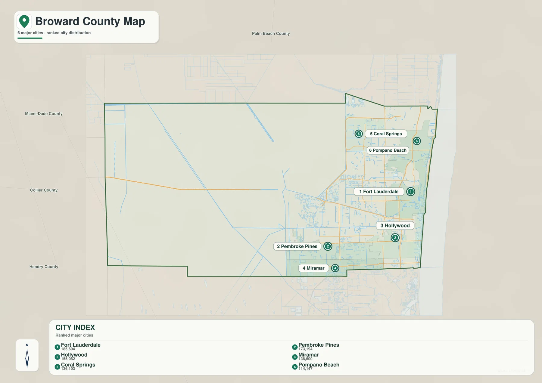
The positions are as useful as the ranking. Fort Lauderdale and Pompano Beach sit in the eastern half, with Hollywood farther south. Pembroke Pines and Miramar form a strong southwestern pair near Miami-Dade County, while Coral Springs stands well to the northwest. This distribution makes it difficult to describe Broward as a single downtown with surrounding suburbs. Several large municipalities occupy different parts of the developed strip, creating a metropolitan county with multiple centers and different north-south and east-west connections.
The map also labels Palm Beach County to the north, Miami-Dade County to the south, and Collier and Hendry counties to the west. That surrounding geography helps explain Broward’s regional role. The eastern cities are part of the continuous Miami–Fort Lauderdale–Palm Beach urban corridor, whereas the west side meets the inland Everglades landscape. The county therefore lies at a transition between one of Florida’s largest coastal metropolitan areas and a very different wetland environment only a short distance to the west.
Waterways are as important as roads on the east side
The water map shifts attention away from streets and city names. The Atlantic Ocean forms the long eastern edge, and the map labels Harbor East Canal near the northeast coast. Around the central developed area it shows the North Fork New River and North Fork Middle River, along with Crystal Lake, Lake Lisa, Lake Jubilee, and The Lagoon at Nob Hill. Markham Lake appears closer to the western development edge. Farther south, Chaves Lake, Dumfounding Bay, and Biscayne Bay appear near the transition toward Miami-Dade County.
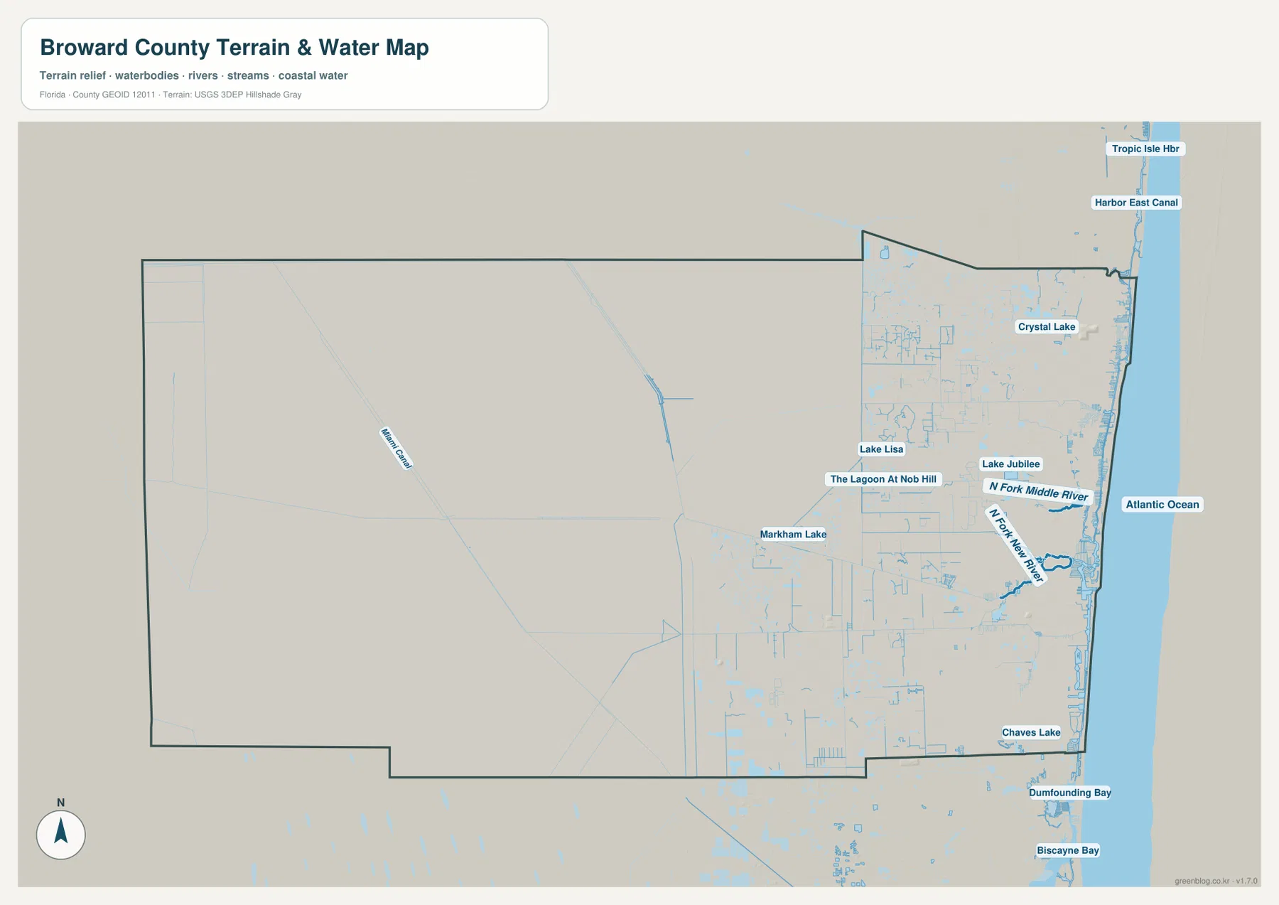
Miami Canal is one of the long linear water features visible across the western side. In the eastern cities, by contrast, many smaller canals, river forks, lakes, and coastal waters sit close together. This matters in places such as Fort Lauderdale because two locations that look close in a straight line may be separated by a river, canal, or inlet and depend on a particular bridge. The map is not a turn-by-turn navigation product, but it explains why water can influence local connections almost as much as road distance.
The western area should also be interpreted as part of South Florida’s water-management system rather than simply as undeveloped land. The source package points to South Florida Water Management District information on the Greater Everglades Ecosystem and its Water Conservation Areas. Those wetlands include broad marsh and water-storage landscapes that differ fundamentally from the residential and commercial environment east of the Sawgrass and I-75 side. The water map makes that contrast easier to understand because it puts the sparse western features in the same frame as the dense network of eastern canals and lakes.
Fort Lauderdale, Port Everglades, and the southeastern transport cluster
Fort Lauderdale is more than a label near the center of the east coast. It sits close to the New River system, the Atlantic-side city corridor, and major north-south roads. Source material in the package identifies Port Everglades as a Broward County-operated seaport on Eller Drive in Fort Lauderdale, near the Atlantic entrance and the eastern end of I-595. Fort Lauderdale-Hollywood International Airport is nearby between Fort Lauderdale and Hollywood. Those facilities make the southeastern part of the county a compact concentration of county government, air travel, port access, interstate connections, and coastal waterways.
That cluster also helps explain why I-595 is so important. Instead of functioning only as a suburban cross-town road, it links the Port Everglades and airport side of the county with Florida’s Turnpike, central municipalities, and I-75 farther west. A reader tracing transportation can therefore start at the Atlantic-side port and move west along I-595, then north or south on the major expressways. The same sequence passes from older eastern urban areas through central Broward and toward newer western municipalities before reaching the conservation edge.
Older coastal cities and the later push west
Broward contains 31 municipalities according to the county demographic material included with the package. The source article also notes that Dania became the first incorporated community in 1904, followed by Pompano in 1908 and Fort Lauderdale in 1911. Those early places were associated with the eastern side of the county, while later metropolitan growth spread much farther inland. On today’s map, large western cities such as Pembroke Pines, Miramar, Coral Springs, and Sunrise are impossible to treat as minor edges of the urban area.
This historical sequence can be seen without turning the page into a history lesson. The older coastal and inner-coastal names remain close to US 1, I-95, and the Atlantic. The later western cities occupy a broad zone around the Turnpike, I-595, I-75, and Sawgrass Expressway. Eventually that broad suburban fabric reaches a firm western limit. The result is one of Broward’s clearest map patterns: a century of urban expansion compressed into the eastern portion of a county whose official boundary extends much farther across the Everglades.
Choosing the right Broward map for the task
Use the county map when you need one view that combines municipal names, principal roads, and the full county outline. It is the best starting point for explaining where Fort Lauderdale sits relative to Coral Springs, Weston, Pembroke Pines, Miramar, and the western county boundary. Use the city map when the goal is to compare the six highlighted population centers without the extra road labels. The water map is better for locating the Atlantic shoreline, river forks, canals, lakes, and the difference between the developed eastern water network and the much broader western conservation landscape.
For print work, classroom reference, planning a regional overview, or comparing nearby counties, the three files can be used separately instead of forcing every layer into one crowded image. The downloadable archive contains the same three map types as high-resolution JPG files: the county map, the city map, and the terrain-and-water map. That makes it possible to use a larger image than the page preview while keeping each map focused on a specific type of information.
Frequently Asked Questions
Why does western Broward County have so few city labels?
Much of the western county is part of the Everglades Water Conservation Areas rather than ordinary urban development. The metropolitan fabric extends through cities such as Weston, Coral Springs, Pembroke Pines, and Miramar, but it drops off sharply farther west. The sparse labels therefore reflect a real change in land use and water management, not a missing group of municipalities.
Which map is best for comparing Broward’s major cities?
The city map is the clearest choice because it marks Fort Lauderdale, Pembroke Pines, Hollywood, Miramar, Coral Springs, and Pompano Beach with numbered points and a City Index. It makes the eastern, southwestern, and northwestern city centers easy to compare without the denser labeling found on the county road map.
Can the terrain and water map be used as a flood or navigation map?
No. It is a reference map for the relative location of the Atlantic coast, rivers, canals, lakes, and other named waters shown in the package. Flood risk, legal boundaries, engineering work, and boat navigation require purpose-built official sources with the appropriate current data and safety information.
Map File Information
Use the ZIP below to download the Broward County county map, city map, and water map as high-resolution JPG files.
- Included Files: Three high-resolution JPG maps: county, city, and water
- File Type: ZIP archive containing three JPG maps
- Intended Use: Printing, education, presentations, and map-based projects
Related Maps
Sources and References
- U.S. Census Bureau QuickFacts — Broward County, Florida — population estimate and land-area reference
- Broward County Demographics Quick Facts — municipality and county demographic context
- Broward County Planning Council — Setting for Countywide Planning — developed eastern area and western Conservation Area
- Florida Department of Transportation — I-595 — major road connections across Broward
- South Florida Water Management District — Everglades — wetland and water-management background
- Port Everglades — port location and Broward County operations
Green Map creates custom-edited map images using open geographic data sources such as geoBoundaries, Natural Earth, OpenStreetMap, and government open data. These maps are edited visual materials, not raw data files, and are provided for education, documents, presentations, and graphic reference.