Baker County, Florida is easiest to understand when Macclenny is used as the starting point rather than the whole story. The county seat and Glen St. Mary form a compact eastern cluster, major roads run east and west toward Jacksonville and north-central Florida, and much of the land farther north and west is occupied by forest, wetlands, creeks, and the headwater network of the St. Marys River. This page explains the three maps included in the current package—a county map, a city map, and a terrain-and-water map—and the same high-resolution JPG files are available together in the download box below.
Each map brings forward a different part of the county, so the page can stay practical without reading like a technical GIS report. One helps with boundaries, roads, and general orientation; another makes the small concentration of incorporated places around Macclenny easy to compare; and the water map brings the river branches, creeks, ponds, and wet northern landscape into focus. Used together, they show why eastern Baker County feels much more connected to the regional road network while the western and northern parts remain sparsely settled.
Table of Contents
Start with Macclenny and the County Frame
Macclenny sits on the eastern side of Baker County and works well as the main reference point for reading the county map. The city is the county seat, and several important roads converge in or near the developed area. From there, the county extends a long distance west and north into much less urbanized country. Georgia lies just beyond the northern county line, while Nassau and Duval Counties are to the east, Clay County is to the southeast, and Columbia, Union, and Bradford Counties help define the western and southern sides.
The road pattern makes that east-west contrast clearer. Interstate 10 and U.S. 90 are the two major east-west routes associated with the main settlement corridor. U.S. 90 passes through the sequence of communities that includes Macclenny, Glen St. Mary, Sanderson, and Olustee, while I-10 provides the faster regional connection across northern Florida. State Road 121 is visible near Macclenny as an important north-south route, and U.S. 301 is another major north-south connection on the eastern side of the county. The map is most useful for seeing where those routes sit in relation to the county boundary rather than for turn-by-turn navigation.
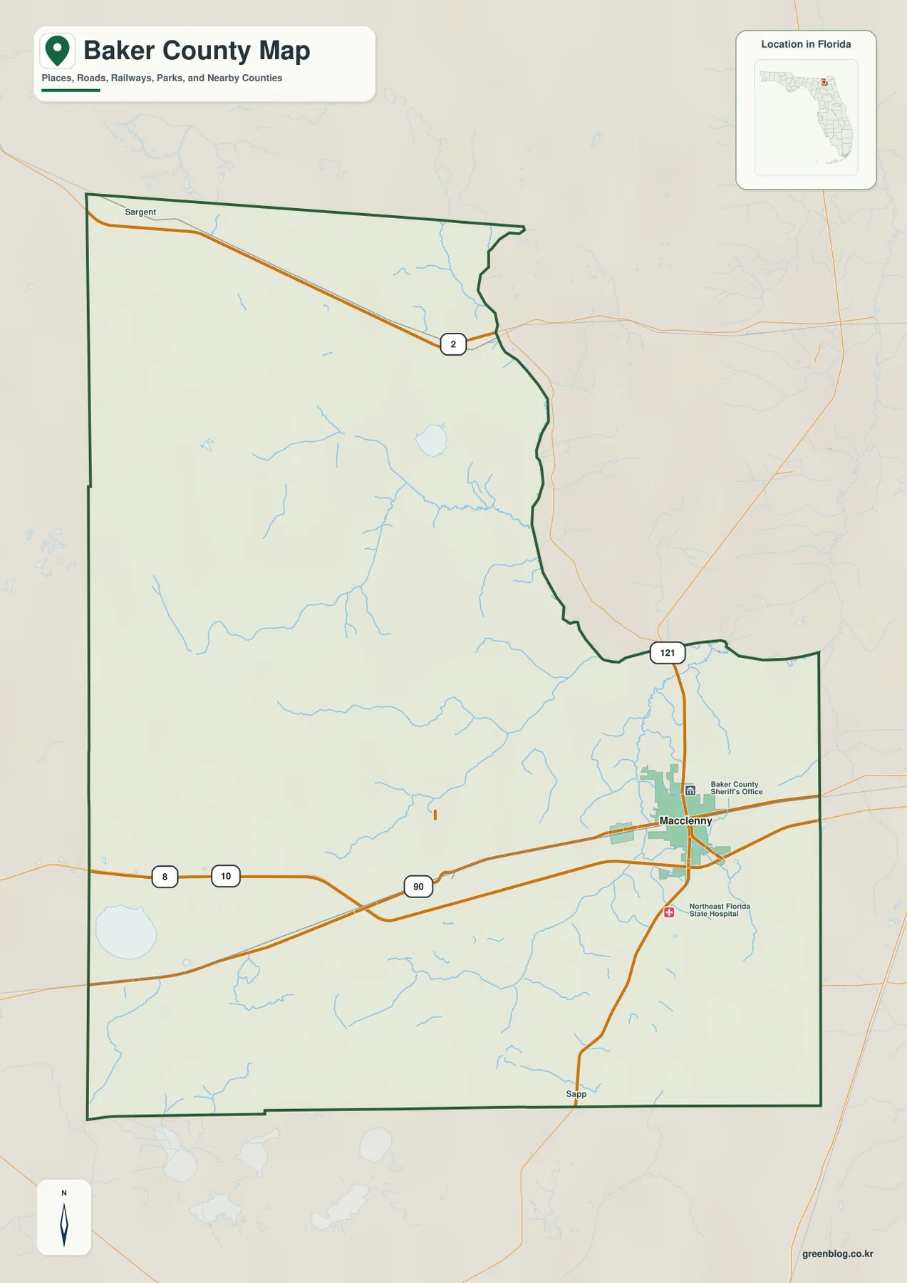
The shape of the county also matters. The boundary is not a simple rectangle; the northeastern and eastern edges step inward before the county broadens toward the southeast. That outline, combined with Macclenny’s eastern position, makes it obvious why a large part of Baker County lies west and north of its main population center. The faint surrounding roads and labels outside the boundary are helpful here because they show how the county connects to the Jacksonville side of northeastern Florida without confusing those neighboring places with locations inside Baker County.
Two Small Municipal Centers in a Large Rural County
The city map narrows attention to the two incorporated places that stand out most clearly at county scale. Macclenny is ranked first in the map index with a displayed value of 7,748, while Glen St. Mary is ranked second with 612. Those figures should be treated as the values printed on this specific map rather than as a substitute for the latest population release. The geographic message is more important: both municipalities occupy the same small eastern part of a county that is otherwise dominated by rural land, forest, wetlands, and scattered communities.
Macclenny and Glen St. Mary are close enough that they can look like one continuous settlement area on a county-scale image, but they are separate municipalities. Macclenny is the county seat and the larger city; Glen St. Mary lies immediately to its west along the U.S. 90 corridor. Farther west, Sanderson and Olustee provide useful reference points even though they are not highlighted as the two ranked municipalities on this map. Their spacing shows how settlement stretches along the road corridor and then thins as the landscape becomes more heavily forested.
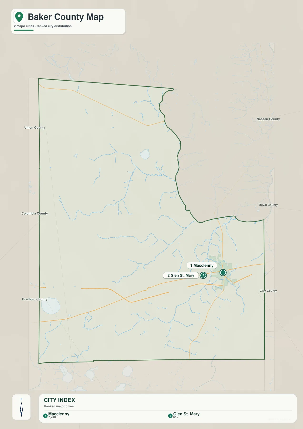
The surrounding county labels provide another useful layer of orientation. Nassau County appears to the northeast, Duval County to the east, and Clay County to the southeast. Columbia County lies to the west, while Union and Bradford Counties are shown along the western and southwestern side. Because Macclenny is close to the eastern edge, these neighboring labels help explain why the most developed road connections face toward Duval County and the Jacksonville region. The broad interior to the north and west, by contrast, contains few comparably large urban labels.
St. Marys River Branches, Creeks, and Wetland Water
The terrain-and-water map changes the emphasis completely. Instead of making roads and cities the dominant features, it highlights the waterways that cross the county. In the north, Middle Prong St. Marys River and Little River are labeled close to one another, with Margys River extending toward the eastern side. Farther south and east, South Prong St. Marys River forms another major named branch. The network is filled in by smaller streams such as Cedar Creek, Calhoun Creek, Turkey Creek, Gum Swamp Creek, and Olustee Creek.
Several named water bodies help anchor the less familiar interior. Ellis Bay appears in the northern half of the county, while Ocean Pond is marked toward the southwest. Granny Bay and Center Bay are shown just south of the county boundary on the broader map context. These features are useful because they break up what can otherwise look like an empty expanse on a road map. In reality, much of Baker County is a wet, forested landscape where small creeks, river branches, bays, ponds, and swampy ground are part of the geography.
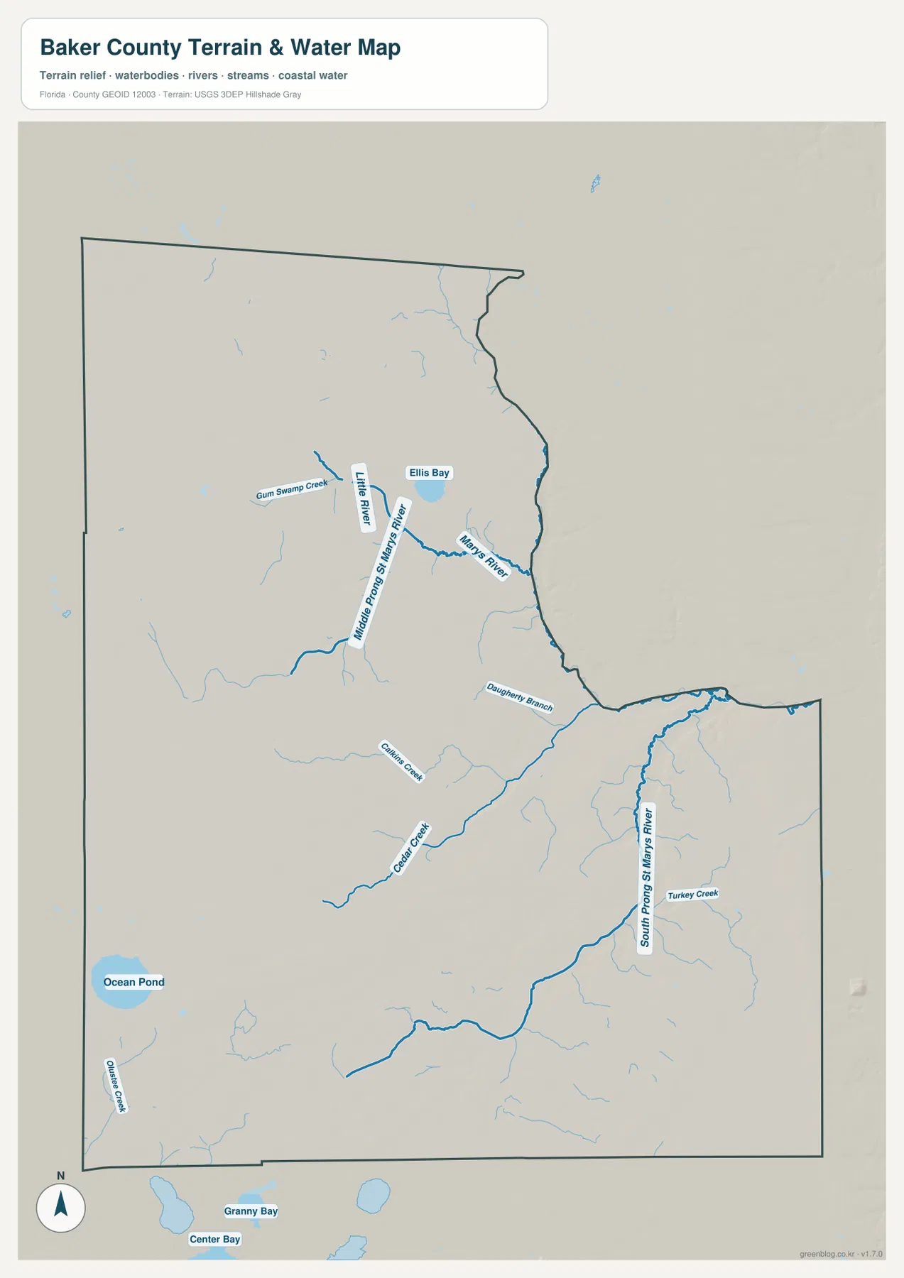
The shaded background gives the map some terrain context, but this package does not include a separate elevation map and the image should not be used as a source of survey-grade heights. Its strength is visual rather than numerical: the relief shading makes the drainage lines easier to follow and helps distinguish the wet northern and western interior from the road-focused eastern settlement area. It is also not a flood-zone, parcel, legal-boundary, or navigation map. Those questions require the appropriate official county, state, or federal map product.
Why the West and North Look So Open
One reason the western half of Baker County has so few large place labels is the amount of public forest and wetland. The source material in this package identifies Osceola National Forest as a major landscape in western Baker County and neighboring Columbia County. The U.S. Forest Service describes the wider Osceola Wildlife Management Area as covering roughly 266,000 acres across that part of northern Florida. Pine flatwoods, swamp, and other wet forest communities occupy large areas, so wide gaps between towns on the map do not simply represent undeveloped suburban land waiting to be filled.
John M. Bethea State Forest provides a second important reference in the north near the Florida–Georgia line. The Florida Forest Service places the forest north of Glen St. Mary and describes wet flatwoods, swamps, bottomland forest, and St. Marys River frontage within the property. That setting fits what the water map shows: many named and unnamed channels cross a landscape with few major urban centers. Reading the forest information beside the water map gives a much clearer explanation for the sparse settlement pattern than simply noting that the county has a low population density.
The eastern side tells a different story. Macclenny and Glen St. Mary are close to the strongest road connections, and the county’s developed area is much more visible there. The current source material lists a July 1, 2025 population estimate of 29,737 and a 2020 land area of 585.23 square miles. Even with population growth since 2020, that is a large amount of land for a relatively small population. A concentrated eastern settlement area can therefore grow while extensive western and northern tracts remain rural, forested, and wet.
From the Eastern Road Corridor to the Wet Interior
For general orientation, begin with the county map. It gives the clearest view of the boundary, Macclenny, nearby road corridors, and the surrounding regional context. Move to the city map when the goal is to compare the two incorporated centers and understand how much of the county lies outside their compact eastern cluster. Finish with the water map when you want to see why the northern and western interior is not simply blank space: the St. Marys River branches, creeks, bays, ponds, and wet forest setting occupy much of that landscape.
This sequence is especially useful for school projects, local geography notes, trip planning at a broad regional level, and simple county comparisons. A teacher can use the county map to establish boundaries and roads, then use the city map to discuss settlement concentration, and finally use the water map to show how natural features influence the look of a rural county. The maps are not intended to replace live navigation, property records, flood maps, or engineering data, but they provide a consistent visual set for learning where the major features are.
The images shown in the article are web-friendly previews. If you need larger originals for printing, presentations, worksheets, or offline reference, the ZIP below contains the corresponding high-resolution JPG files for all three available map types. The archive name includes both Baker County and Florida, which makes it easier to keep the files separate from counties with the same name in other states.
Frequently Asked Questions
Are Macclenny and Glen St. Mary the same municipality?
No. Macclenny is a city and the Baker County seat, while Glen St. Mary is a separate town immediately to its west. Their close spacing along the U.S. 90 corridor makes them appear as one compact eastern settlement area at county scale, but they have separate municipal identities.
Why are there so few large communities in northern and western Baker County?
Those parts of the county contain extensive forest, wetlands, river branches, and public land associated with places such as Osceola National Forest and John M. Bethea State Forest. The road and city maps therefore show large gaps between major settlement labels. The gaps reflect the county’s real rural and natural landscape rather than missing map data.
Can the water map be used for flood zones or property boundaries?
No. The terrain-and-water map is a reference map for locating rivers, creeks, ponds, and broader terrain context. It does not establish flood risk, ownership, legal parcel lines, navigation status, or engineering elevations. For those purposes, use the appropriate official county GIS, FEMA, state, or federal data source.
Map File Information
This ZIP contains the high-resolution JPG versions of the Baker County, Florida county map, city map, and terrain-and-water map shown on this page.
- File Type: ZIP containing 3 JPG files
Related Maps
Sources and Further Reference
- Baker County GIS and Map Library — county mapping and local reference
- U.S. Census Bureau QuickFacts — population, land area, and density
- U.S. Forest Service — Osceola Wildlife Management Area — western forest landscape
- Florida Forest Service — John M. Bethea State Forest — northern forest and St. Marys River setting
- Florida Department of Transportation — I-10 Exit Numbers — regional interstate connections
Green Map creates custom-edited map images using open geographic data sources such as geoBoundaries, Natural Earth, OpenStreetMap, and government open data.
These maps are edited visual materials, not raw data files, and are provided for education, documents, presentations, and graphic reference.