Download the high-resolution A3 JPG ZIP for the Hawkins County Map directly from this page; it includes the county, city, water, and elevation maps shown below. Rogersville sits near the middle as the county seat, Church Hill and Mount Carmel are larger city references in the east, Surgoinsville lies between them, and Bulls Gap marks the southwest. Holston River follows the long central valley, while high ridges rise along the northwestern and southeastern sides of the county.
Hawkins County is easier to understand as a long valley-and-ridge county than as a simple line of towns. Rogersville, Surgoinsville, Church Hill, and Mount Carmel sit within or close to the lower central corridor. US 11W follows much of the same general direction, and the Holston River adds a second natural line through the county. On both sides, long ridges and smaller creek valleys create the relief that controls many local road and drainage patterns.
Table of Contents
Church Hill and Mount Carmel lead the city ranking, while Rogersville remains the county seat
The city map ranks Church Hill at 7,139 residents, Mount Carmel at 5,472, Rogersville at 4,647, Surgoinsville at 1,911, and Bulls Gap at 948. Those numbers make Church Hill the largest ranked city on the supplied layer, but Rogersville still serves as the county seat. Population rank and county-government role therefore point to different places.
The locations are just as useful as the ranking. Rogersville is near the center, Surgoinsville lies east of it, and Church Hill and Mount Carmel continue the settlement pattern toward the eastern end and the Kingsport side. Bulls Gap is separated from that central-eastern chain and lies in the southwest, where the road network and terrain have a different shape.
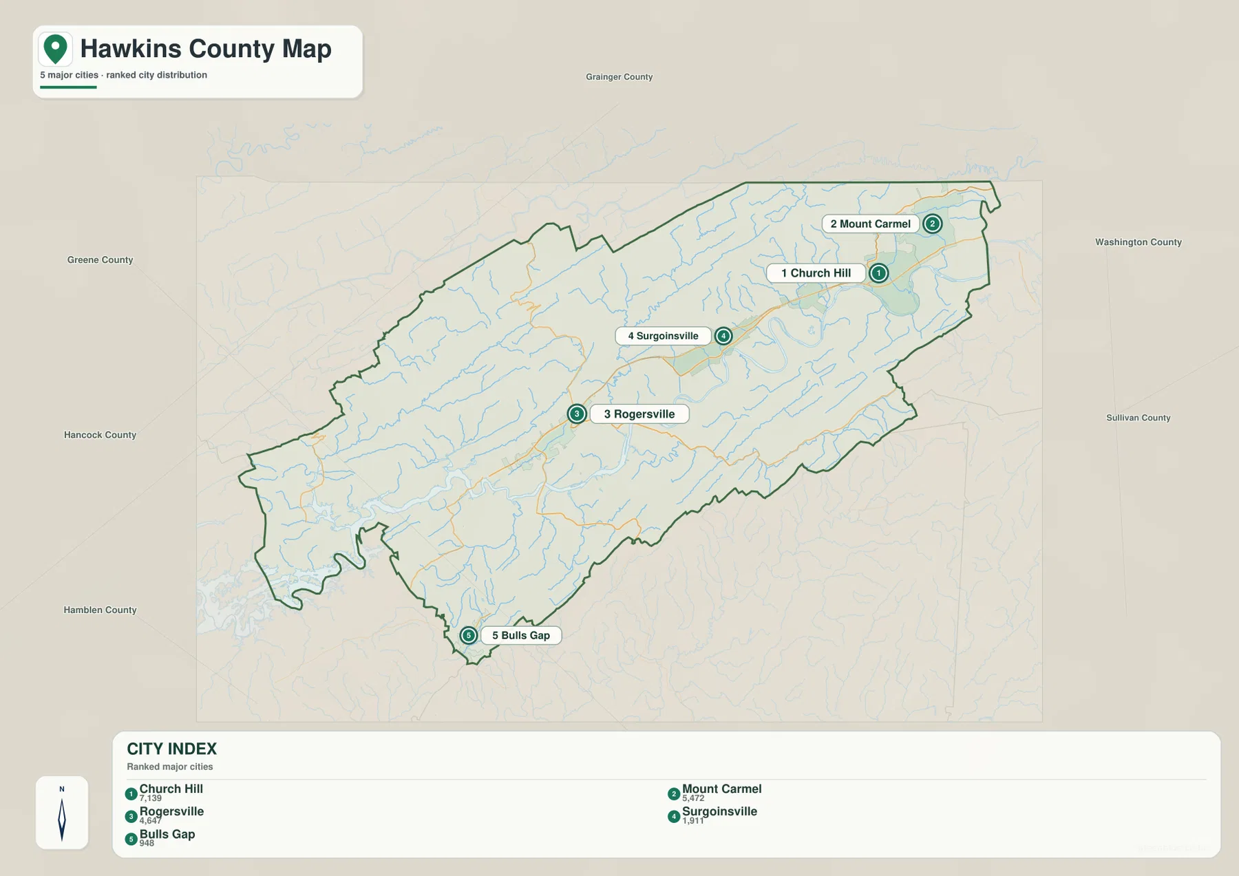
The outer map labels include Grainger, Greene, Hancock, Hamblen, Washington, and Sullivan counties. These references help frame Hawkins County’s long east–west outline. Church Hill and Mount Carmel are close to the eastern side, while Bulls Gap sits much closer to the southwestern boundary, making each group useful for a different part of the county.
US 11W follows the main settlement corridor through Rogersville and Surgoinsville
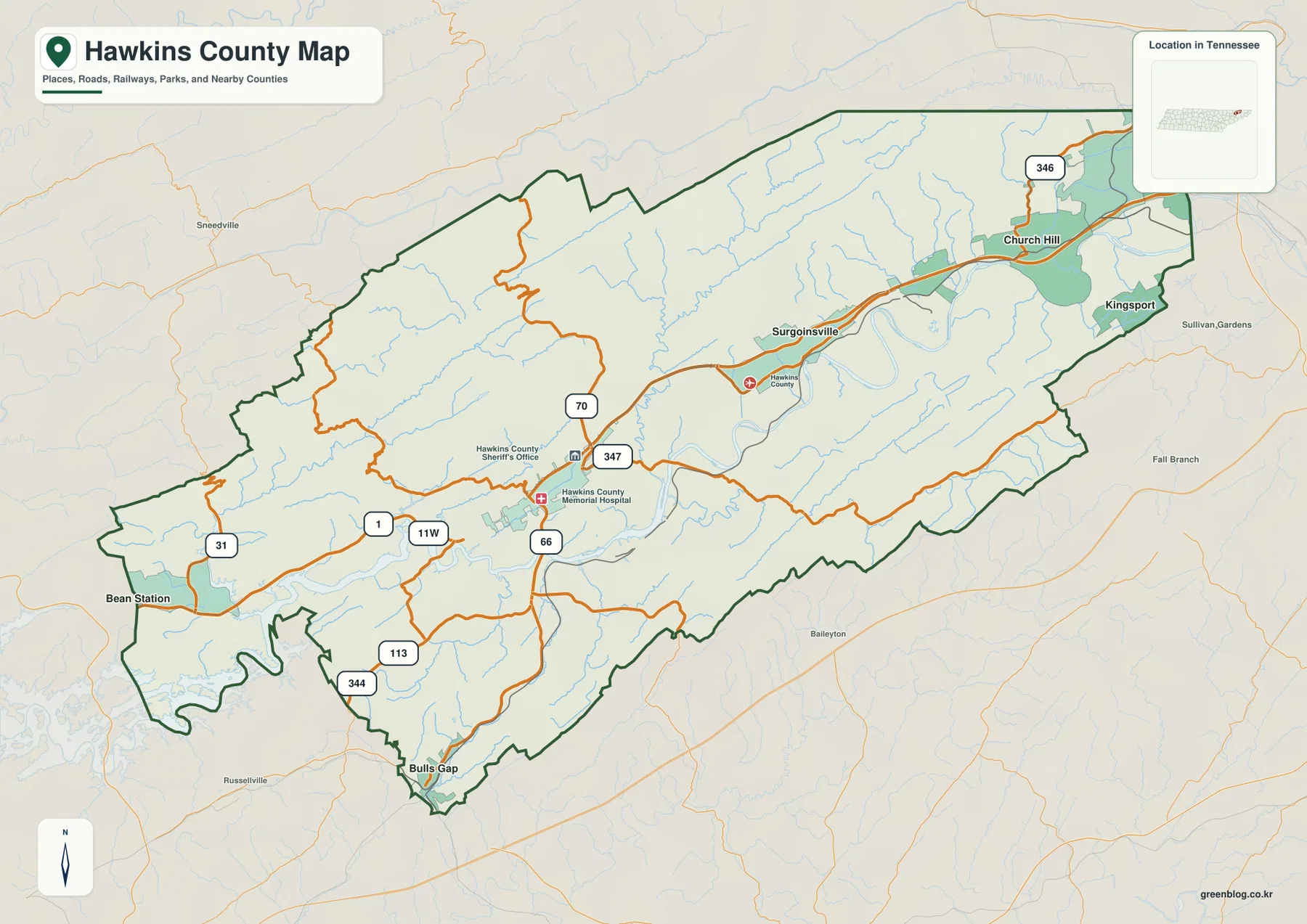
US 11W is the easiest long road to follow on the base map. It crosses the central county through the Rogersville area and continues east through Surgoinsville toward Church Hill. Route 1 is shown in the western-central section, while Routes 66, 70, and 347 meet or pass near Rogersville and provide additional north–south or local connections.
The southwestern side uses a different road pattern. Routes 113 and 344 are labeled around Bulls Gap, and Route 31 appears farther west. This part of the county contains a more broken mix of short ridges and valleys, so the roads do not simply continue the straight east–west pattern of the Rogersville–Church Hill corridor.
Near Church Hill, Route 346 extends northward, and the map becomes denser as it approaches the Kingsport side. The Rogersville area also labels the Hawkins County Sheriff’s Office and Hawkins County Memorial Hospital, giving the base map recognizable central reference points. For quick orientation, start with US 11W and Rogersville, then add the route serving the destination rather than trying to read every numbered line at once.
Holston River forms the central water corridor between long ridges
Holston River is the dominant named water feature on the supplied water map. It enters from the broader southwestern water area, winds through the center, and continues east along the lower valley. Its direction closely matches the long shape of the county, making the river one of the best natural references for understanding where Rogersville, Surgoinsville, and the main road corridor sit.
Big Creek descends through the central-northern area toward the Holston corridor. Poor Valley Creek and Caney Creek occupy separate valleys farther west, while War Creek follows a northern ridge-and-valley passage. In the east, Ransom Creek and Beech Creek add another set of lower channels between the higher ridges.
Several smaller named waters help with local orientation. Jones Pond and Ledford Pond are in the west, Pressmens Home Lake is in the west-central area, and Clearwater Pond and Heck Pond are farther south. Silver Lake appears in the northeast, while Robertson Creek provides another southwestern reference. These smaller features show how thoroughly the main valley is divided by tributaries and local basins.
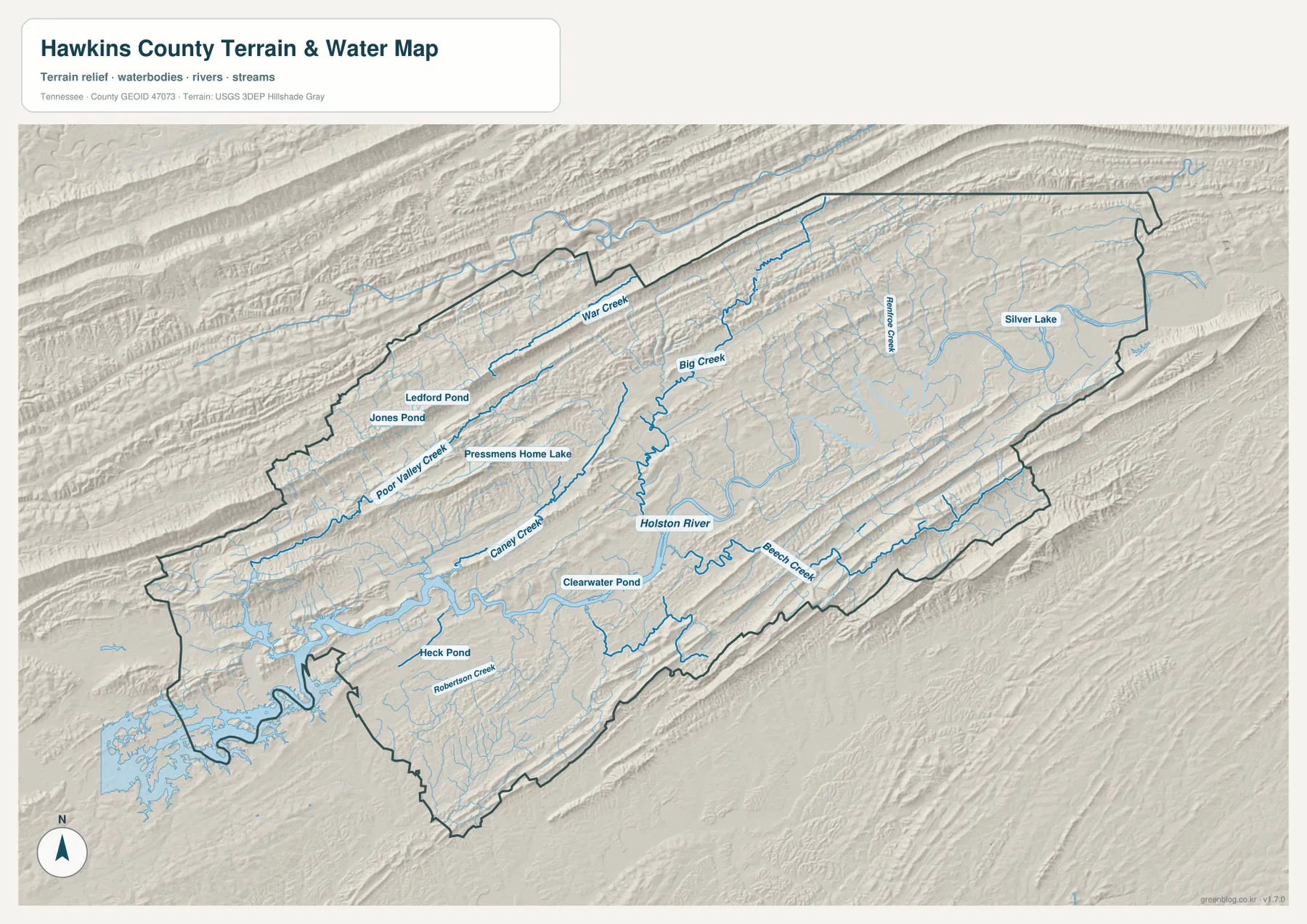
This water layer is intended for geographic reference rather than current water conditions. It does not establish flood limits, safe crossings, navigable access, or property boundaries. Its main value here is showing how towns and roads fit between the Holston River corridor and the smaller creek valleys on both sides.
A 319–931 m range separates the Holston valley from high parallel ridges
The elevation map shows an actual county range of about 319 to 931 meters, with a mean near 432 meters. Green lower terrain spreads through the central and southwestern part of the county, closely following the Holston River and several tributaries. Brown and tan ridges become much more prominent along the northwestern side, and another long high belt follows the southeastern edge.
The northwest is especially rugged. Long ridges run roughly southwest to northeast, with narrow green valleys cutting between them. War Creek, Big Creek, and Poor Valley Creek occupy some of those lower passages. Roads in this terrain generally use gaps and valley floors instead of crossing the highest ground directly.
The southeastern side repeats the ridge-and-valley pattern on a smaller but still distinct scale. Beech Creek and other tributaries occupy lower corridors, while higher ridges run parallel to them. Rogersville, Surgoinsville, and Church Hill lie in or near the broad lower Holston corridor between these higher belts, helping explain why the towns, river, and US 11W share a similar overall direction.
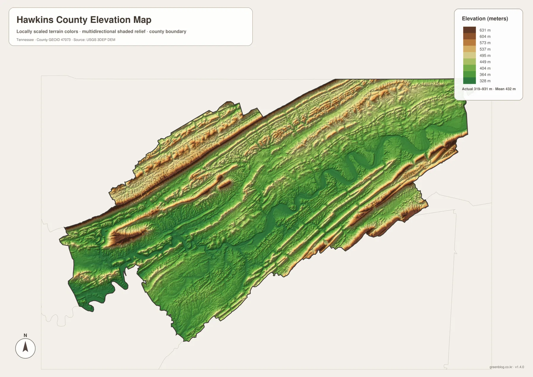
The terrain colors are intended for relative comparison across the county, not for a survey-grade elevation at a specific property. They are useful for explaining why US 11W and the main settlements follow the lower central corridor and why many tributaries and local roads run in long, narrow valleys between ridges.
Rogersville, US 11W, and Holston River form the county’s central reference corridor
The city map first establishes Church Hill and Mount Carmel as the largest ranked cities, Rogersville as the central county seat, Surgoinsville as the intermediate eastern town, and Bulls Gap as the southwestern outlier. The base map then shows US 11W tying much of the central-eastern settlement pattern together. The water map adds Holston River along the same broad valley.
The elevation layer explains why these features line up. The central corridor is lower than the long ridges to the northwest and southeast, so towns, roads, and the river occupy a natural passage through the county. Bulls Gap sits in a more broken southwestern area with shorter ridges and valley connections, making it look different from the Church Hill side even on the same map scale.
Use the city map for ranked places and broad orientation, the county map for roads and local facilities, the water map for Holston River and named tributaries, and the elevation map for the contrast between the central valley and the high parallel ridges.
Choosing and downloading the A3 JPG maps
The WebP images in the article are convenient for quick viewing, while the JPG originals in the ZIP are better for printing, enlargement, and offline reference. For route notes, use the county map and mark only Rogersville, the destination, and the roads needed. Keep river and creek labels on the water map so they do not cover the road network.
The elevation image is especially useful in color because the low Holston corridor and high northwestern and southeastern ridges are separated by strong terrain shading. A3 output also provides more room for labels such as Big Creek, Caney Creek, Beech Creek, and Routes 66, 70, 113, 344, and 346 than the browser preview.
The downloadable ZIP contains the high-resolution A3 JPG originals for the county, city, water, and elevation maps shown on this page. They can be used for classroom comparison, presentations, route notes, regional study, or personal offline storage when a larger image is more useful than the web preview.
Frequently Asked Questions
Why is Rogersville the county seat if Church Hill is larger on the city map?
The city map ranks Church Hill at 7,139 and Rogersville at 4,647. Rogersville is the county seat and administrative center, while Church Hill is the larger ranked city on the eastern side. Population rank and county-seat status describe different roles.
How large is the elevation difference between the Holston valley and the surrounding ridges?
The elevation map shows roughly 319–931 meters. The central and southwestern Holston corridor is much lower, while long ridges along the northwestern and southeastern sides rise several hundred meters above the valley floor.
Sources and reference data
County boundaries and general location can be compared with U.S. Census Bureau TIGER/Line. Local history and county reference material are available from the Tennessee State Library and Archives Hawkins County fact sheet, and the road network can be compared with the Tennessee Department of Transportation Hawkins County map.
For broader hydrography reference, see USGS National Hydrography. Elevation data can be compared with the USGS 3D Elevation Program. The descriptions on this page are based on the places, roads, water features, and elevation patterns visible in the supplied Hawkins County maps.
Map File Information
Download the high-resolution A3 JPG originals for the Hawkins County county, city, water, and elevation maps shown in this article.
- Included Files: County map, city map, water map, elevation map
- File Type: ZIP containing 4 JPG files
Related Maps
- Sequatchie County Tennessee map | Dunlap and Sequatchie Valley
- Alamo to Gadsden: A Crockett County Tennessee Map
- Altamont, Monteagle, and Plateau Valleys — Grundy County Tennessee Map
Green Map creates custom-edited map images using open geographic data sources such as geoBoundaries, Natural Earth, OpenStreetMap, and government open data. These maps are edited visual materials, not raw data files, and are provided for education, documents, presentations, and graphic reference.