Download the high-resolution A3 JPG ZIP for the Hardin County Tennessee Map directly from this page; it includes the county, city, water, and elevation maps shown below. Savannah is the main city and county-seat reference, Crump sits just west across the Tennessee River corridor, and Saltillo is farther north. Kentucky Lake is labeled along the northern river reach and Pickwick Lake occupies the south, while the eastern half of the county rises into more closely spaced hills and creek valleys.
Hardin County is easiest to understand by treating the Tennessee River as the central geographic reference without assuming that both sides look the same. Savannah and Crump lie close to broad low river terrain. East of Savannah, the surface becomes more dissected and higher, with creeks cutting long green corridors through the hills. South toward Counce and Pickwick Lake, broad water and low ground become important again.
Table of Contents
Savannah, Crump, and Saltillo give the county three clear settlement references
The city map ranks Savannah at 7,412 residents, Crump at 1,231, and Saltillo at 753. Savannah is the largest of the three and the county seat. Crump is close by on the western side of the Tennessee River corridor, while Saltillo is much farther north, making it useful for locating the upper part of the county.
The city layer also provides straight-line connectors from Savannah. Crump is shown at about five miles and Saltillo at about eleven miles. Those values are not driving mileage, but they make the settlement pattern easy to grasp: Savannah and Crump form a close pair around the river crossing, whereas Saltillo is a separate northern reference.
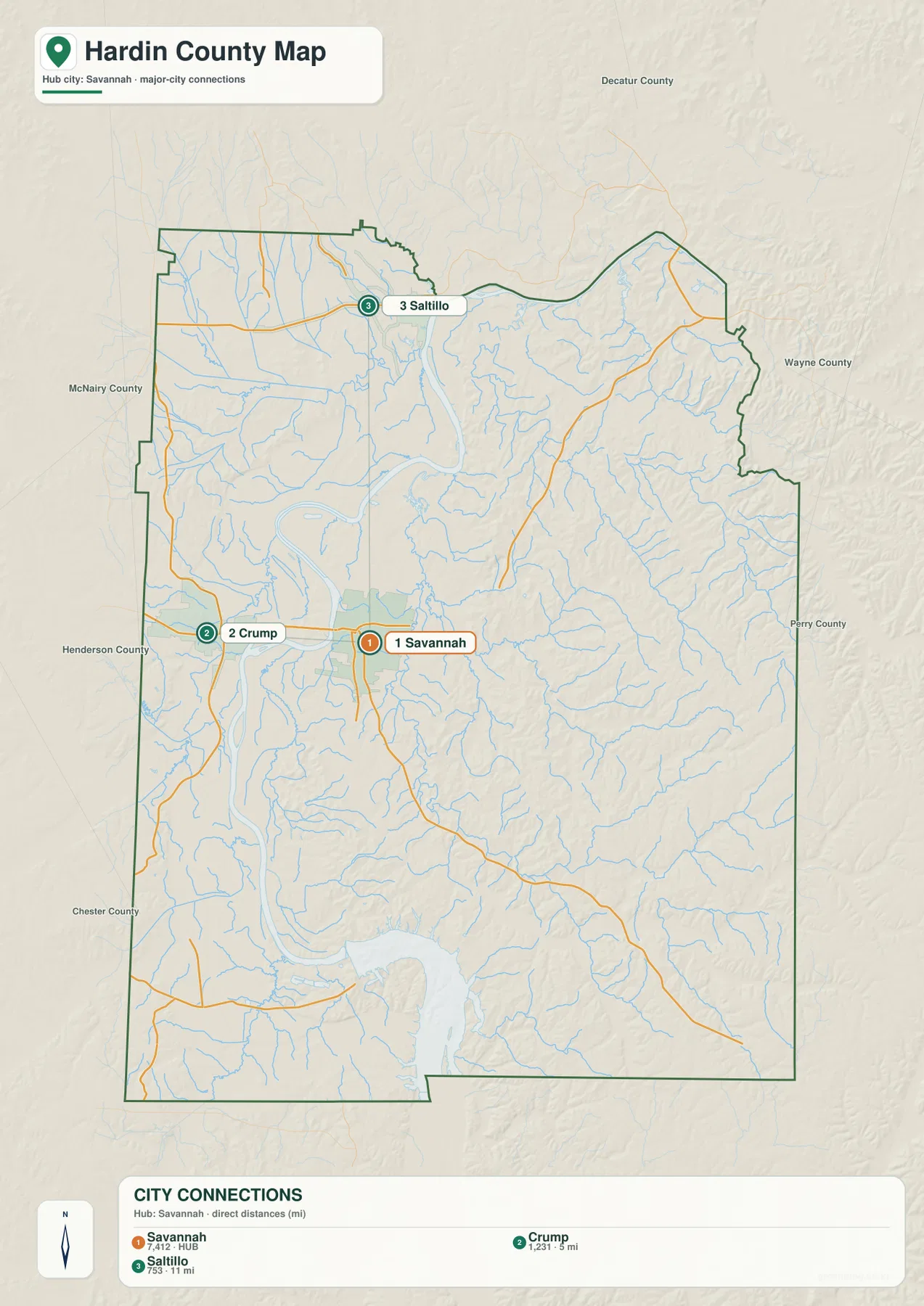
McNairy, Henderson, Chester, Decatur, Wayne, and Perry counties appear around the outside of the city map and help orient the county outline. Crump is closest to the western side, Saltillo is closer to the northern boundary, and the eastern half contains fewer ranked city labels but a much denser pattern of streams and hills. That difference becomes much more obvious on the water and elevation layers.
US 64 crosses the Tennessee River while other routes split north, south, and east
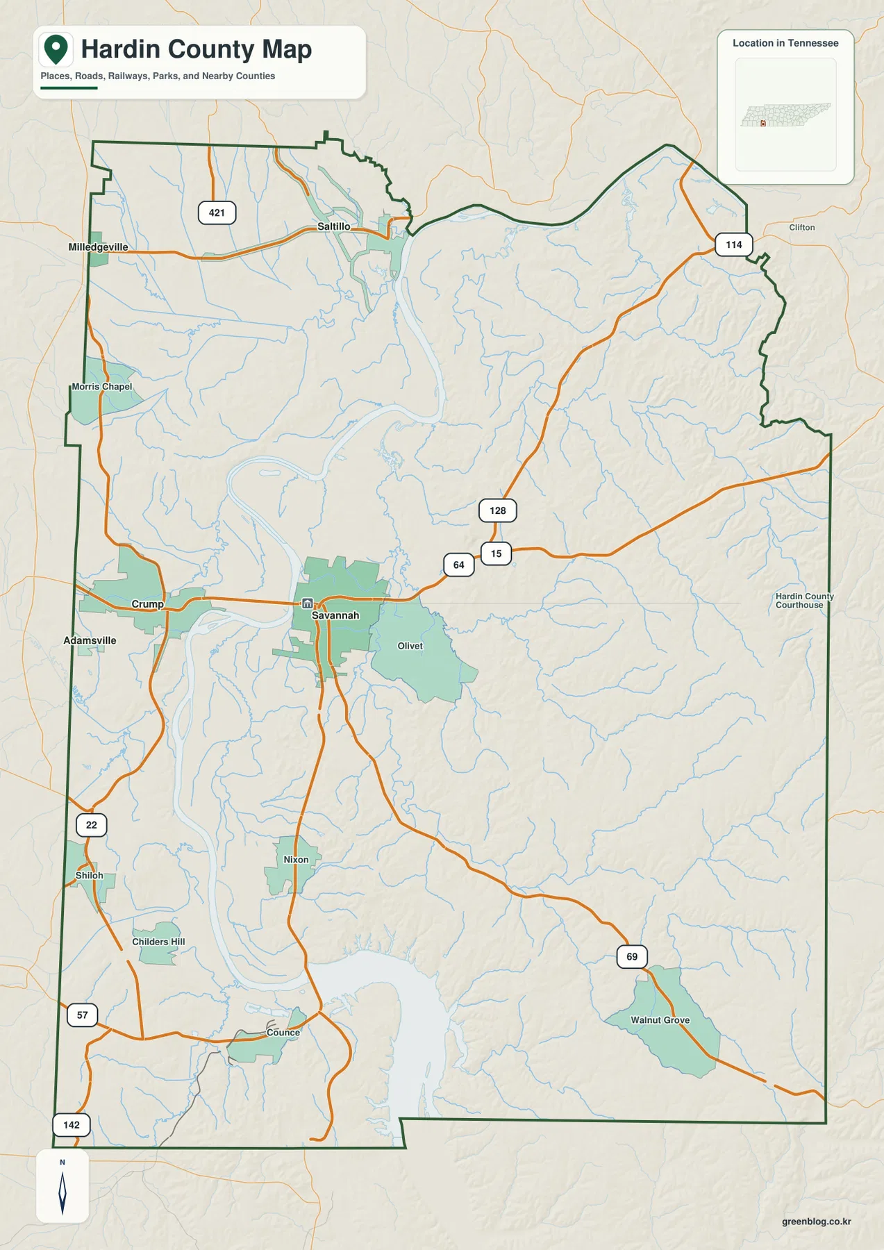
The base map makes US 64 the easiest road to identify. It links Crump and Savannah across the Tennessee River and continues east toward Routes 15 and 128. Route 421 is visible in the northern area near Saltillo, while Route 114 reaches toward the northeastern edge near the Clifton side.
South of Savannah, Route 22 follows the Shiloh side of the county. Routes 57 and 142 provide additional southern references, and Route 69 runs through Walnut Grove in the southeast. Nixon and Counce sit along the route network leading toward the Pickwick Lake side. These labels make the southern half easier to navigate than a simple county outline would suggest.
Milledgeville and Morris Chapel appear in the northwest, while Olivet is east of Savannah. The western river lowland and the eastern hills create different road patterns: roads near the river can follow broad lower ground, while routes farther east bend around short ridges and creek valleys. For a quick reading, start with US 64, then add the northbound or southbound route that leads toward the area of interest.
Tennessee River connects Kentucky Lake in the north with Pickwick Lake in the south
The Tennessee River is the dominant water feature on the supplied map. It enters from the north, bends through the west-central county, and continues toward the broad Pickwick Lake water in the south. The northern reach is labeled Kentucky Lake. Savannah and Crump sit close to this main water corridor, which is why the river is also central to reading the road map.
Whiteoak Creek and Salt River are prominent in the northwest. Whiteoak Creek reaches toward the Tennessee River through the upper western part of the county. Indian Creek follows a longer valley through the north-central and eastern interior, while Hardin Creek is visible farther east near the county edge. These streams occupy low corridors that stand out clearly on the elevation layer.
South of Savannah, Beason Creek and Mud Creek appear close to the river lowland, and Johnson Pond is labeled near the Tennessee River. Horse Creek and Turkey Creek form longer drainage references across the central-southern and southeastern hills. Big Gum Pond is marked farther north. Together, these smaller waters show that the river is not the only important drainage feature in the county.
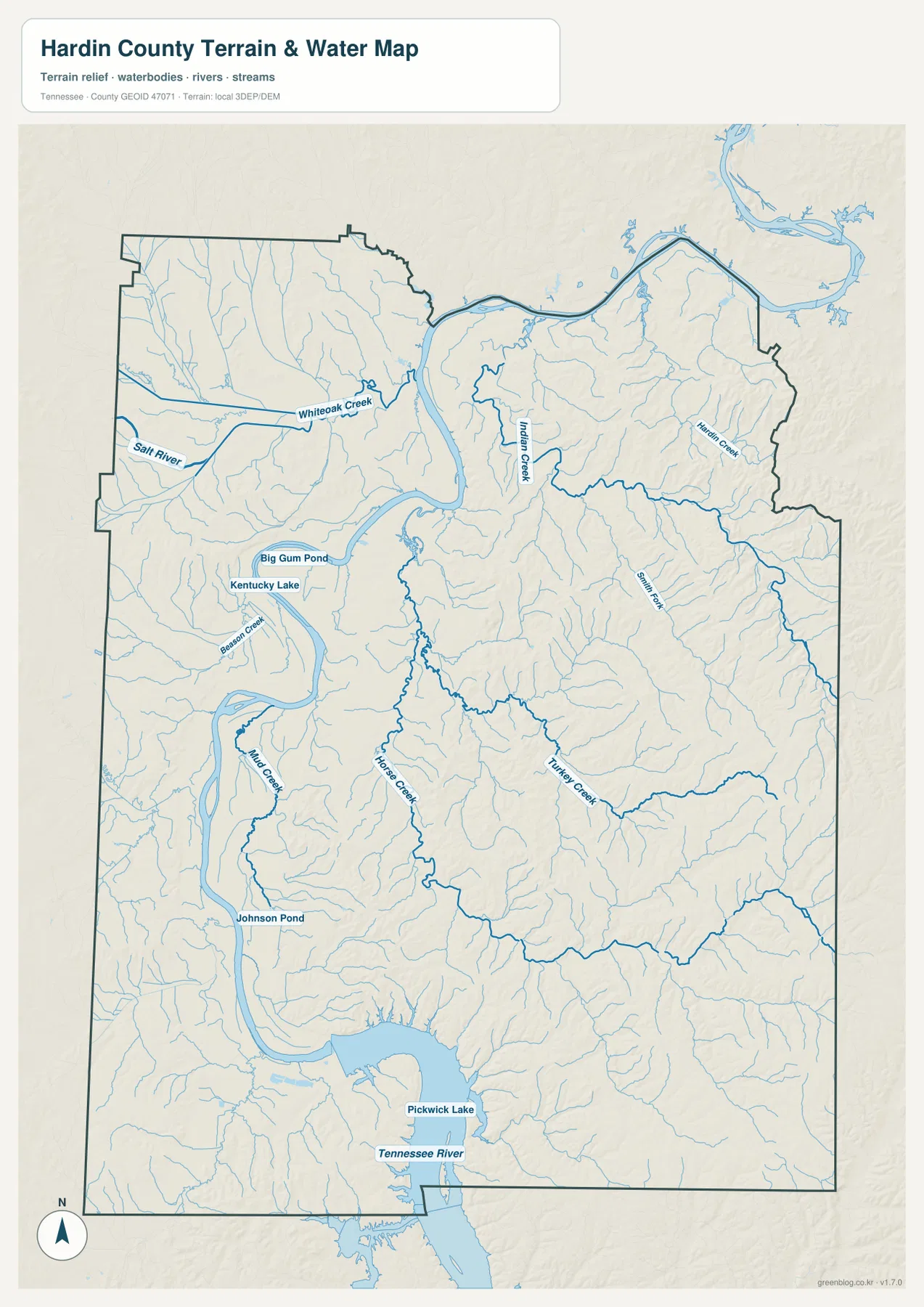
This water layer is intended for geographic reference rather than current water conditions. It does not establish flood limits, boating access, shoreline ownership, or a water level for a specific date. Its value here is showing how Savannah, roads, river reaches, and the eastern creek valleys fit together.
A 98–257 m range separates broad river lowlands from the higher eastern hills
The elevation map shows an actual range of about 98 to 257 meters, with a mean near 155 meters. The darkest green low ground follows the Tennessee River, Kentucky Lake, and Pickwick Lake corridor. Tributary valleys extend outward from that low zone, while the eastern and southeastern county shifts into much more extensive yellow, tan, and brown hills.
The eastern half is deeply cut by small streams. Instead of one continuous high plateau, short ridges repeat between creek valleys, and those lower corridors appear as green lines across the hillier surface. Horse Creek and Turkey Creek provide good examples in the southern interior. The road map becomes easier to understand once those valleys are compared with the elevation shading.
The west is generally lower near the main river, but it is not completely flat. Short hills rise in the northwest and southwest, while broad low terrain remains most continuous along the Tennessee River itself. South of Savannah, the Pickwick Lake corridor stays low, then the surface rises again toward Counce and the eastern side. Hardin County is therefore best read as a large river lowland bordered and dissected by rolling uplands rather than as a simple east-high, west-low slope.
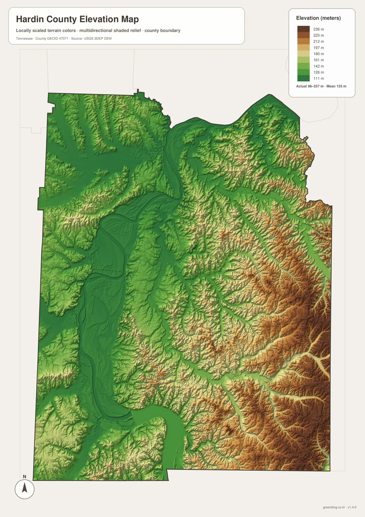
The terrain colors are intended for relative comparison across the county, not for a survey-grade elevation at a specific property. They are useful for showing why the river and creeks occupy broad or narrow low corridors and why roads in the eastern half bend around the surrounding hills.
Savannah links the river crossing, northern settlements, and the Pickwick Lake side
The city map first establishes the close Savannah–Crump relationship and the more distant northern position of Saltillo. The base map adds the US 64 crossing and the roads toward Shiloh, Counce, and the eastern hills. The water layer then makes the Tennessee River the main geographic divider, with Kentucky Lake to the north and Pickwick Lake to the south.
Elevation completes the picture. Crossing from Savannah to Crump is primarily a river-and-lowland relationship. Moving east from Savannah toward Olivet brings more ridges and tributary valleys into view. Traveling south toward Counce returns to broad water and low terrain around Pickwick Lake before the land rises again farther east.
Use the city map for Savannah, Crump, Saltillo, and their direct-distance comparison. The county map is better for numbered routes and outer place labels, the water map is best for the Tennessee River and named creeks, and the elevation map makes the river-lowland versus eastern-hill contrast easiest to see.
Choosing and downloading the A3 JPG maps
The WebP images in the article are convenient for quick viewing, while the JPG originals in the ZIP are better for printing, enlargement, and offline reference. For route notes, use the county map and mark only Savannah, the destination, and the roads needed. Keep river, lake, and creek labels on the water map so they do not cover the road network.
The elevation image is especially useful in color because the Tennessee River lowland and eastern hills are separated by strong terrain shading. A3 output also provides more room for Whiteoak Creek, Indian Creek, Horse Creek, Turkey Creek, and Routes 64, 22, 69, and 128 than the browser preview.
The downloadable ZIP contains the high-resolution A3 JPG originals for the county, city, water, and elevation maps shown on this page. They can be used for classroom comparison, presentations, route notes, regional study, or personal offline storage when a larger image is more useful than the web preview.
Frequently Asked Questions
What do the Savannah-to-Crump and Savannah-to-Saltillo distances mean?
The city map shows straight-line distance, not driving mileage. Crump is about five miles from Savannah on that layer, while Saltillo is about eleven miles away to the north. The labels are most useful for comparing relative position and spacing.
How different is the Tennessee River lowland from the eastern hills?
The elevation map shows roughly 98–257 meters. The Tennessee River and Pickwick Lake corridor is the broadest low area, while the eastern and southeastern county contains higher, more closely spaced ridges cut by creek valleys.
Sources and reference data
County boundaries and general location can be compared with U.S. Census Bureau TIGER/Line. Local history and county reference material are available from the Tennessee State Library and Archives Hardin County fact sheet, and the road network can be compared with the Tennessee Department of Transportation Hardin County map.
For broader hydrography reference, see USGS National Hydrography. Elevation data can be compared with the USGS 3D Elevation Program. The descriptions on this page are based on the places, roads, water features, and elevation patterns visible in the supplied Hardin County maps.
Map File Information
Download the high-resolution A3 JPG originals for the Hardin County county, city, water, and elevation maps shown in this article.
- Included Files: County map, city map, water map, elevation map
- File Type: ZIP containing 4 JPG files
Related Maps
Green Map creates custom-edited map images using open geographic data sources such as geoBoundaries, Natural Earth, OpenStreetMap, and government open data. These maps are edited visual materials, not raw data files, and are provided for education, documents, presentations, and graphic reference.