You can download the Meigs County Tennessee Map files on this page as one ZIP containing four high-resolution JPGs suitable for A3 printing. The accompanying map views show Decatur, outer place names, major roads and the county boundary, the ranked city reference, the Tennessee River and named creeks, and elevation from about 204 to 394 meters.
The county is easiest to orient from Decatur and SR 58. SR 58 runs through the long north-south body of the county, while SR 30 crosses the central area near Decatur and Union Grove. The Tennessee River repeatedly bends along the western side, sending broad arms toward the county, and a dense set of creeks drains the interior. On the relief map, lower river and creek valleys contrast with narrow ridges that become especially visible through the central and eastern portions of the county.
Table of Contents
Decatur and SR 58 organize the long county outline
On the county reference map, Decatur is the clearest starting point because it sits near the middle of the long, narrow shape and is marked as the county seat. SR 58 approaches from the south, passes the Decatur area, and continues toward the northeastern end. SR 30 provides a second direction near Union Grove, creating an east-west reference across the central part of the county.
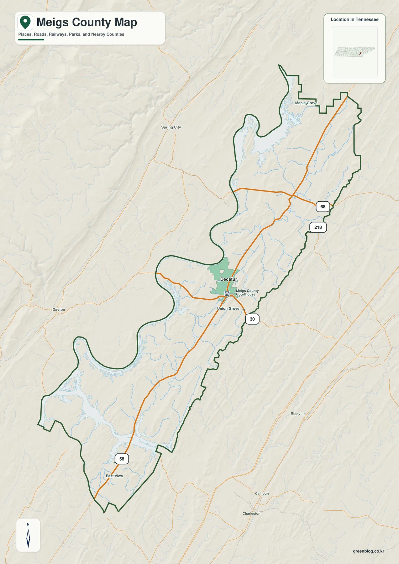
Union Grove appears just south of Decatur, while East View is much farther down the SR 58 corridor near the southern end. Maple Grove sits near the northern end where the county narrows around broad water inlets. These labels are useful because they divide the county into recognizable northern, central, and southern sections instead of reducing the map to Decatur alone.
The northeastern road pattern is different from the Decatur area. Route numbers 68 and 218 appear close to the eastern edge, while the main SR 58 line continues through the county. The map is not intended to show every local intersection, so the most useful reading order is to identify the long SR 58 direction first, add the SR 30 cross-county reference, and then use 68 and 218 to place the northeastern road network.
Places shown outside the dark county boundary provide regional orientation without implying that they are inside Meigs County. Spring City and Dayton appear to the west, Riceville to the east, and Calhoun and Charleston farther southeast. When a road or place name sits close to the outline, the boundary line should be checked before treating that feature as part of the county.
The city view makes Decatur the single ranked urban reference
The supplied city map deliberately strips away much of the label clutter found on the reference map. Its city index contains one ranked major city: Decatur, shown as number 1 with the figure 1,898. That does not mean the county contains only one community. It means that, under the ranking used for this particular map, Decatur is the one city emphasized for a clean county-scale comparison.
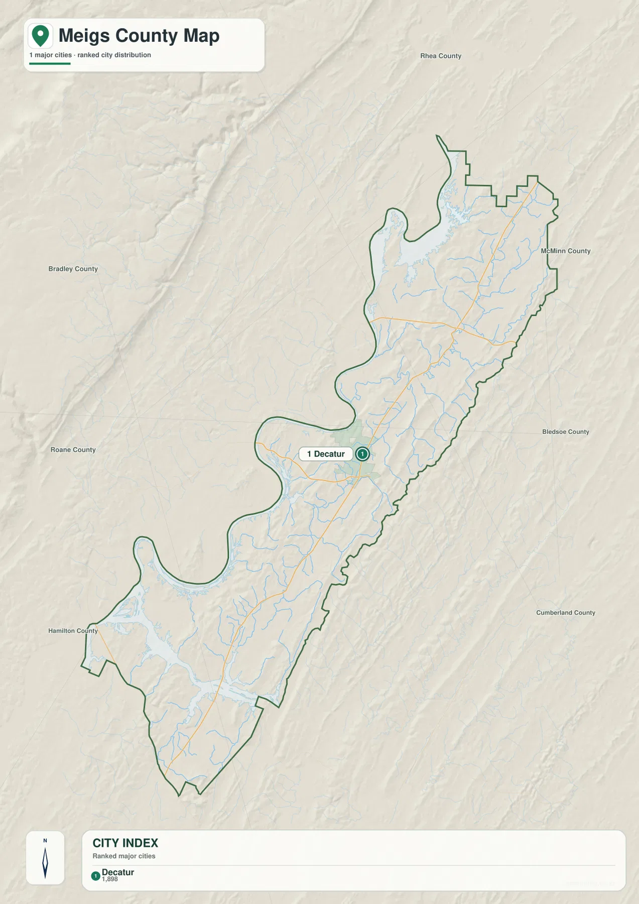
Because only one city is ranked, the value of this sheet is positional rather than comparative. Decatur sits roughly where the long southern section transitions toward the wider northern river bends. The city symbol gives readers a quick anchor before they return to the more detailed reference map to locate Union Grove, Maple Grove, East View, or the numbered state routes.
The surrounding labels also help show how isolated the county shape can feel on a small regional map. Rhea County is labeled to the north, McMinn County to the east, and other county names appear farther around the frame. Those labels are background orientation aids; the bold Meigs County outline remains the feature that determines which roads and settlements belong inside the map.
Tennessee River bends dominate the west while creeks drain the interior
The water map has a very different visual center from the city sheet. The Tennessee River occupies much of the western side and makes several large bends, with wide reservoir-like arms pushing toward the county. This broad water edge helps explain why the county outline is irregular and why a straight east-west line is often a poor way to judge distance across the western half.
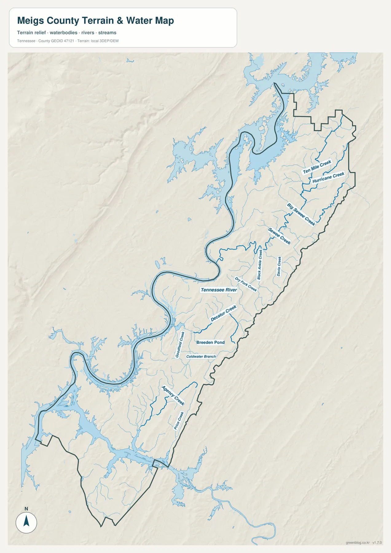
In the northeast, Ten Mile Creek and Hurricane Creek are labeled on neighboring drainages. Farther south, Big Sewee Creek and Sewee Creek occupy the eastern interior. These channels sit among a series of narrow valleys rather than on one broad plain, a pattern that becomes even clearer when the same area is compared with the elevation sheet.
Around the middle of the county, Black Ankle Creek, Davis Creek, and Dry Fork Creek lead toward the Tennessee River. Decatur Creek is labeled south of the river bend near Decatur, and Breeden Pond provides a small standing-water reference nearby. Goodfield Creek and Coldwater Branch add more detail to the central-southern drainage network.
The southern half continues with Agency Creek and Price Creek, while numerous smaller unnamed tributaries feed the larger channels and broad water arms. This map is designed for location and comparison, not for judging current water level, flood risk, navigability, depth, or shoreline access. Those questions require current information from the relevant water, emergency, or land-management authority.
A 204–394 meter range reveals repeated ridges and creek valleys
The elevation map reports an actual countywide range of roughly 204 to 394 meters, with a mean near 246 meters. The lowest tones cluster around the Tennessee River and broad creek valleys, while browner and more strongly shaded strips mark higher ground. Rather than one isolated mountain, the county contains many narrow, elongated ridges separated by lower drainages.
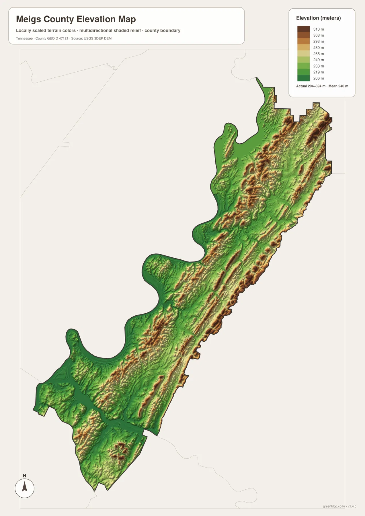
The northern and eastern portions show especially clear ridge-and-valley texture. Long raised bands run in roughly the same general direction as the county itself, while lower green corridors cut between them. Comparing those corridors with Ten Mile Creek, Hurricane Creek, and Big Sewee Creek on the water map makes the relationship between streams and low ground easy to see without relying on technical terrain terminology.
The central and southern sections repeat the same idea at a smaller scale. Decatur Creek and Agency Creek occupy lower corridors, while nearby ridges rise on either side. The relief sheet therefore helps explain why roads and streams rarely form a perfect grid, but it should not be used to infer a precise road grade or the elevation of an individual property.
These colors represent a generalized county-scale surface. The 204–394 meter range is useful for comparing parts of the county, but parcel elevations, engineering slopes, drainage design, and surveying require more detailed source data. For this page, the elevation image works best as a companion to the water and road maps rather than as a stand-alone measurement tool.
Choose the sheet that fits the question, then download the JPG set
For general orientation, the county reference map is the most complete starting point because Decatur, outer communities, roads, the boundary, and water are visible together. The city map is cleaner when Decatur’s position is the only settlement question that matters. The water sheet is better for the Tennessee River, Ten Mile Creek, Decatur Creek, or Agency Creek, while the elevation map adds the ridge-and-valley background.
The supplied county figures also provide useful scale without replacing what the maps show. The 2020 census count is listed as 12,758, with a July 2025 estimate of 14,186. The same supplied references list 195.1 square miles of land and 21.5 square miles of water. Those totals describe the county as a whole; they should not be interpreted as the population or area of Decatur or any individual creek valley.
The WebP images on the page are intended for convenient online viewing. The download ZIP contains the matching high-resolution JPG files for the county, city, water, and elevation maps. Keeping the views separate is useful for A3 printing, classroom work, presentations, reports, or personal annotations because roads, waterways, labels, and relief do not have to compete for space on a single crowded image.
Frequently Asked Questions
Why is Decatur the best first reference on the county maps?
Decatur is the county seat and is clearly marked on both the detailed reference map and the simplified city sheet. SR 58 runs through the same central area and continues for much of the county’s length, so the combination of Decatur and SR 58 makes it easy to place Union Grove, East View, Maple Grove, and the other numbered routes afterward.
Which map shows Ten Mile Creek and the Tennessee River most clearly?
Use the water map. It emphasizes the Tennessee River’s wide western bends and labels Ten Mile Creek, Hurricane Creek, Big Sewee Creek, Decatur Creek, Agency Creek, and several other waterways. It is a static location reference, however, and does not provide current flood stage, water depth, or navigation conditions.
What does the 204–394 meter elevation range tell me?
It is the actual range reported on the supplied elevation sheet, which also gives a mean near 246 meters. Lower river and creek corridors appear differently from the narrow higher ridges in the central and eastern portions of the county. The map is suitable for county-scale comparison, not parcel surveying or engineering calculations.
Map File Information
The ZIP contains high-resolution JPG files for the Meigs County reference, city, water, and elevation maps, prepared for A3 use.
- Included Files: County map, city map, water map, elevation map
Related Maps
- Decatur County Tennessee map | Tennessee River and Parsons
- Alamo to Gadsden: A Crockett County Tennessee Map
- Altamont, Monteagle, and Plateau Valleys — Grundy County Tennessee Map
Sources and References
- Tennessee State Library and Archives: Meigs County fact sheet
- Tennessee Department of Transportation: Meigs County road reference
- U.S. Census Bureau QuickFacts: Meigs County
- USGS National Hydrography
- USGS 3D Elevation Program
Green Map creates custom-edited map images using open geographic data sources such as geoBoundaries, Natural Earth, OpenStreetMap, and government open data. These maps are edited visual materials, not raw data files, and are provided for education, documents, presentations, and graphic reference.