You can download the McNairy County Map set on this page as high-resolution JPG files sized for A3 printing. The four supplied views separate information that becomes crowded on a single sheet: the county reference map shows towns and major roads, the city map ranks six settlements, the water map names creeks and ponds, and the elevation map shows the county’s relief from about 111 to 208 meters.
Selmer is the easiest place to start. It sits near the middle of the county where the east-west US 64 corridor meets the main north-south travel pattern. Adamsville lies well to the east, Bethel Springs and Finger are to the north, and Eastview, Ramer, Guys, and Michie spread across the southern half. That broad settlement pattern is matched by a surprisingly dense network of creeks: Little Hatchie Creek follows the western side, Cypress Creek runs through the interior, and the southwest contains Big Hill Pond, Pocahontas Lake, and the Tuscumbia River.
Table of Contents
US 64 makes Selmer the clearest road reference
The county reference map places Selmer at the center of the most recognizable road pattern. US 64 enters from the west, crosses the Selmer area, and continues toward Adamsville. A major north-south corridor comes down from the Finger and Bethel Springs side before continuing through the central county toward Eastview. Reading those two directions first makes the smaller state-route numbers much easier to place.
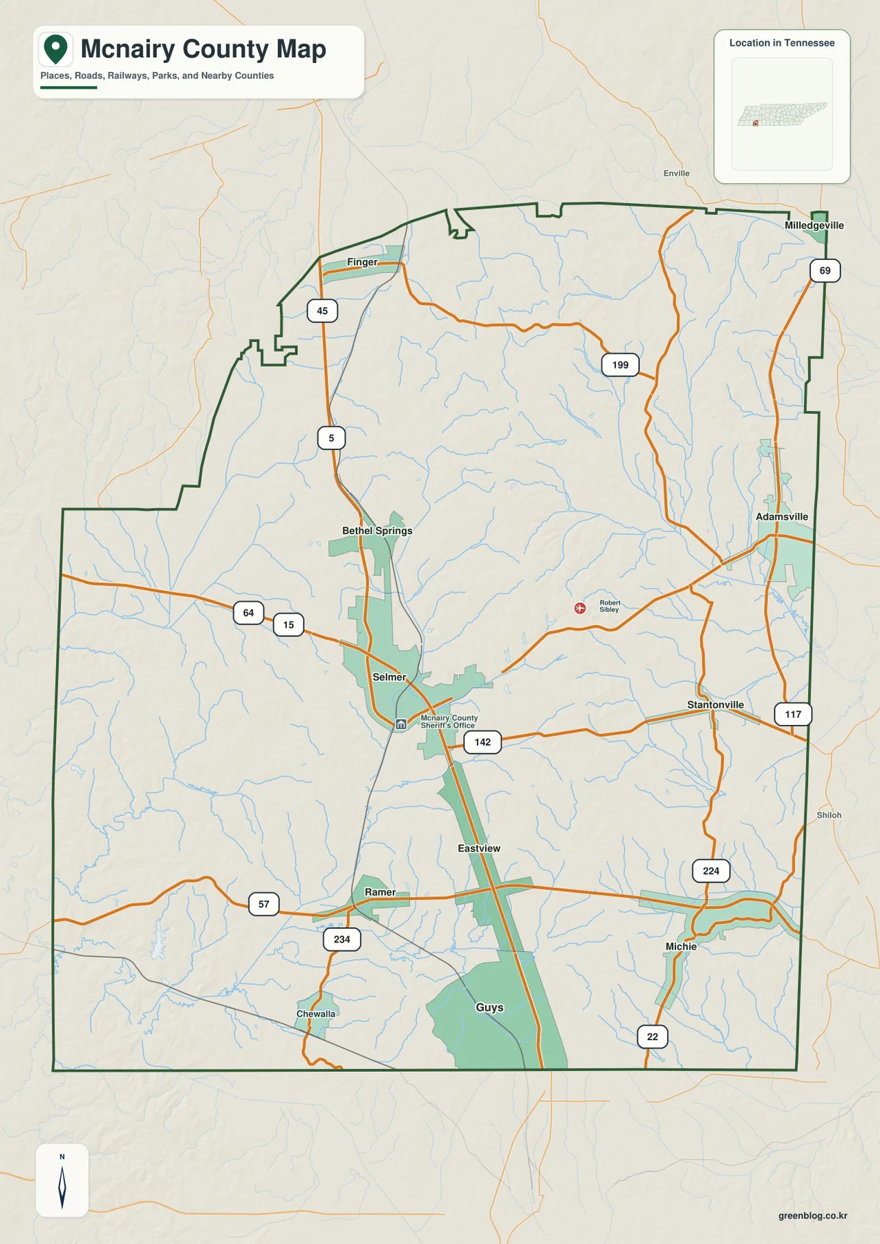
Several smaller places help define the outer parts of the county. Bethel Springs is north of Selmer, with Finger farther northwest. Adamsville stands apart on the eastern side. South of Selmer, Eastview follows the central corridor while Ramer sits to the southwest; Guys and Michie mark different parts of the southern edge, and Stantonville provides another eastern reference. Chewalla is useful when locating the southwest corner. Together, these labels show that McNairy County is not arranged around one compact urban cluster.
The state-route layer adds useful detail without changing that basic layout. SR 57 crosses the southern portion near Ramer, while route 142 runs east from the Selmer area toward Stantonville. The eastern half also shows 199, 117, and 224, and route 22 appears near the southeast. These lines are useful for county-scale orientation, but the image is not meant to replace current navigation, construction, or bridge information.
The surrounding labels provide another check on location. Chester County is shown to the north, Hardin County to the east, and Hardeman County along the west. Madison and Henderson counties appear on the western and southwestern side of the city-distribution view. The supplied article data also identifies Alcorn County, Mississippi, along the southern border. Those edges matter when a road, creek, or community continues beyond the McNairy County outline.
Creeks split the county into several drainage directions
The water map is one of the most distinctive views in this set because it names features that are easy to miss on the road map. Little Hatchie Creek follows the western side of the county, while Cypress Creek occupies a long interior corridor. In the northeast, White Oak Creek, Snake Creek, and Lick Creek branch through a separate group of valleys. The result is a county with many small drainage lines rather than one dominant river running through the center.
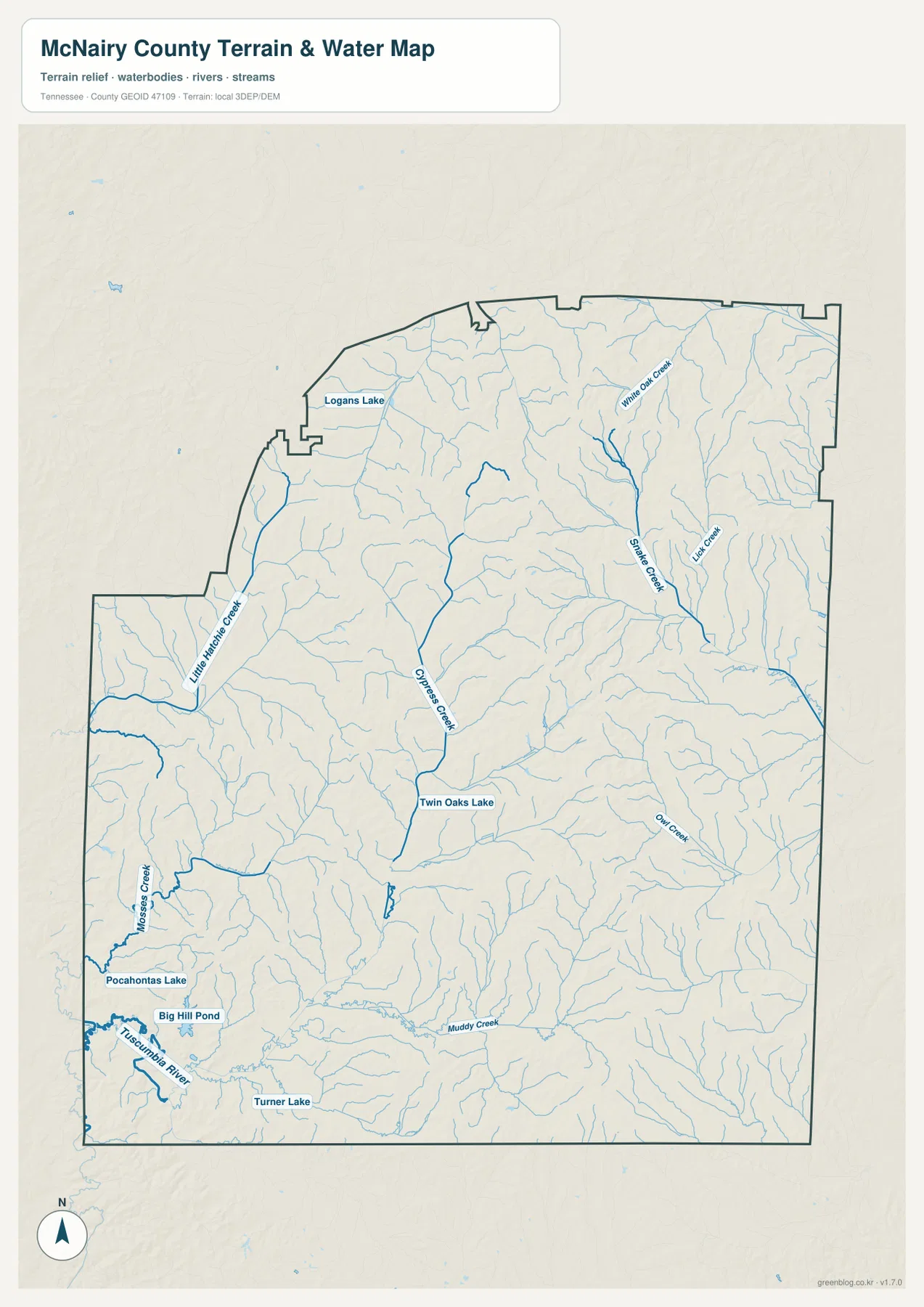
The southwest has a different appearance from the northeast. Moses Creek runs along the western side, and Pocahontas Lake, Big Hill Pond, and the Tuscumbia River are grouped in the lower-left part of the map. Turner Lake lies farther south, while Muddy Creek crosses the southern interior. This cluster of named water bodies makes the southwest especially easy to recognize when comparing the water and elevation views.
Other features fill in the middle and northern parts of the county. Twin Oaks Lake sits near the central corridor, Logans Lake is in the northwest, and Owl Creek is marked on the eastern side. These names should be used as geographic reference points rather than as claims about current water level, flood risk, boating access, or shoreline ownership. The map shows where the features are, not their live operating or hazard conditions.
For a classroom or report, the water map works best beside the road map. A reader can locate Selmer and the main highways on the county view, then switch to the water layer to see which valleys and creeks occupy the same part of the county. That comparison is more informative than treating every blue line as an isolated name.
The six-city index shows a dispersed settlement pattern
The city-distribution map simplifies the county and highlights six ranked places. Its index lists Selmer at 4,488, Adamsville at 2,278, Eastview at 767, Finger at 669, Bethel Springs at 664, and Michie at 558. Selmer is clearly the largest of the six, but the location of the other five is just as useful: they are spread toward the east, north, and south rather than forming a continuous built-up belt.
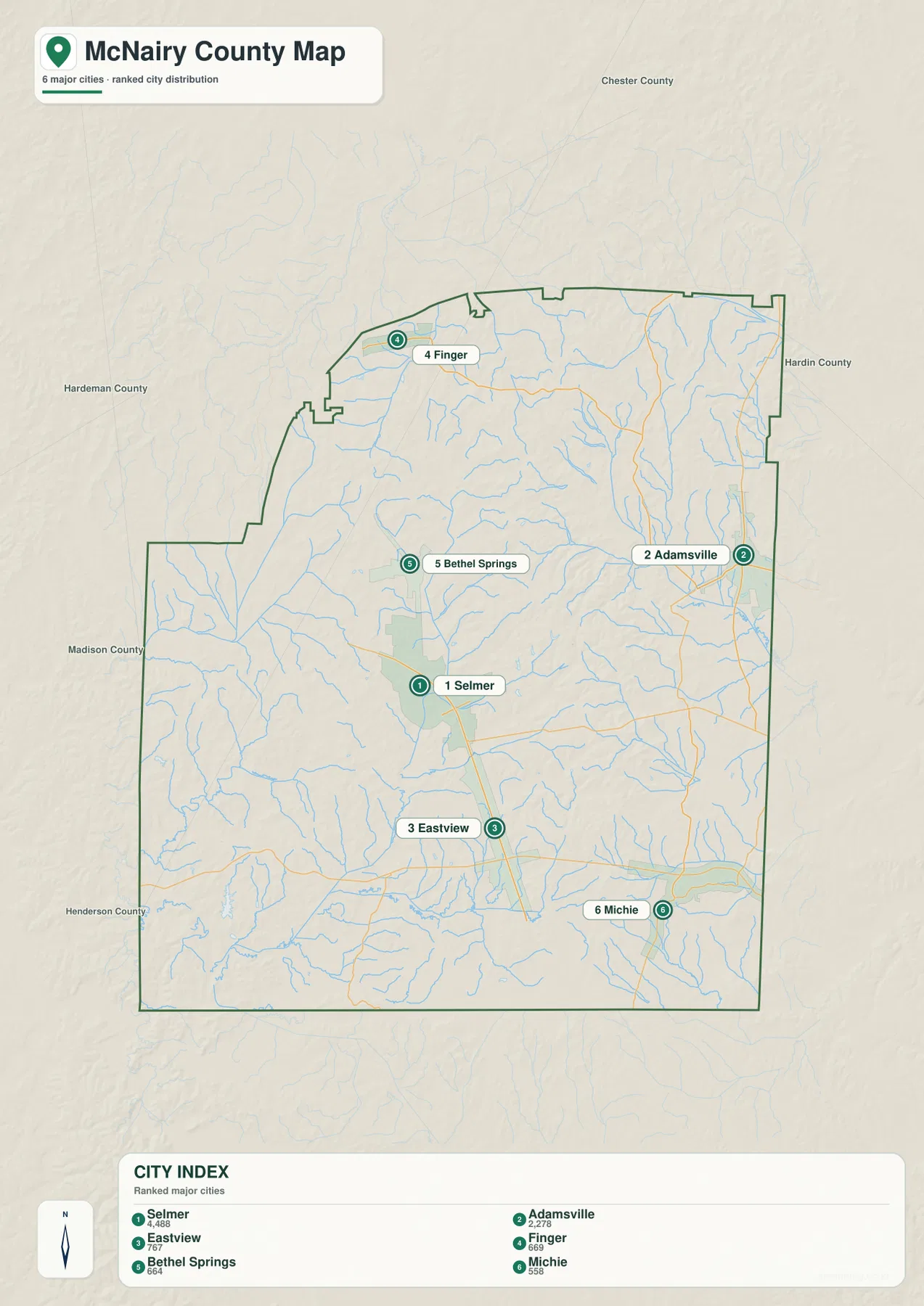
Adamsville is the strongest eastern center on the map. Finger marks the northern end, while Bethel Springs lies closer to Selmer. Eastview extends the central settlement corridor southward, and Michie sits well to the southeast. Because the map emphasizes rank and location rather than every named community, places such as Ramer, Guys, Stantonville, and Chewalla are better found on the county reference map.
This distinction is useful when choosing an illustration. The city map is cleaner when the goal is to explain where the main settlements are relative to one another. The county map is better when the same places need to be tied to specific roads and the county boundary. Using each image for the question it answers avoids turning one map into an overloaded collection of labels.
Elevation ranges from 111 to 208 meters across a broken hill-and-valley surface
The elevation map reports an actual range of about 111 to 208 meters, with a mean near 147 meters. That is a moderate countywide range, yet the shaded relief reveals many short ridges and branching low valleys. Brown and tan ridges are especially noticeable through the central and north-central interior, while green corridors trace lower ground between them. Another group of higher hills appears in the southeastern part of the county.
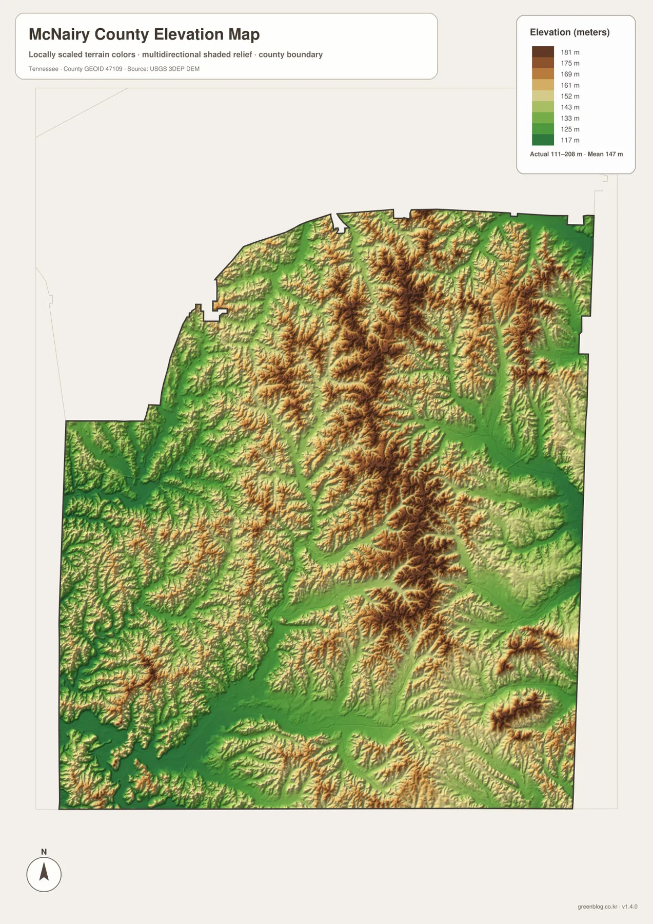
The low corridors become easier to interpret when the elevation view is compared with the water map. Long green bands line up with several creek valleys, including parts of the Little Hatchie and Cypress systems. Around Big Hill Pond and the Tuscumbia River in the southwest, lower terrain broadens before giving way to smaller hills. The terrain therefore helps explain why the water network branches so extensively across the county.
This is a generalized county-scale elevation surface, not a parcel survey or engineering product. It is appropriate for comparing the relative height of ridges and valleys, preparing a geography lesson, or adding terrain context to a map presentation. Exact site elevation, slope, and construction decisions require a more detailed authoritative dataset.
The road map also becomes easier to read after looking at the relief. Major corridors tend to use the broader low routes between hillier areas, while smaller roads spread into the side valleys. The map set does not claim that terrain alone determines every road location, but the visual relationship is useful for understanding why the network is irregular rather than a simple grid.
Choose the file that matches the question you need to answer
For a general location reference, start with the county map because it combines Selmer, outer communities, roads, and the boundary. Use the city view when the settlement ranking and geographic spread are the main topic. The water view is the better choice for Little Hatchie Creek, Cypress Creek, Big Hill Pond, or the Tuscumbia River, while the elevation image adds the ridge-and-valley background that is absent from the other sheets.
The supplied county data also gives a useful sense of scale. The 2020 census count is 25,866, and the July 2025 estimate is 26,236. Gazetteer figures list about 562.8 square miles of land and 0.8 square miles of water. Those countywide numbers do not describe the size of Selmer or Adamsville on the map, but they help place the settlement and terrain views in a broader geographic context.
The body images are WebP previews for convenient page viewing. The download archive contains the matching high-resolution JPG files for the county, city, water, and elevation maps. They can be printed at A3 size, placed in reports or presentations, or kept as separate layers of reference so that roads, settlements, waterways, and relief do not compete for space on one image.
Frequently Asked Questions
Why is Selmer the best starting point on the McNairy County map?
Selmer is the county seat and sits close to the intersection of the county’s most obvious east-west and north-south travel patterns. From Selmer, US 64 leads toward Adamsville to the east, while Bethel Springs and Finger lie to the north and Eastview lies to the south. Starting there makes it easier to place both the major roads and the outer communities.
Where should I look for Big Hill Pond and the Little Hatchie Creek system?
Big Hill Pond is shown in the southwest near Pocahontas Lake and the Tuscumbia River, while Little Hatchie Creek follows the western side farther north. The water map is the clearest sheet for these features because it also labels Moses Creek, Cypress Creek, Twin Oaks Lake, and several eastern creeks. It should not be used as a flood-stage or boating-conditions map.
What does the 111–208 meter elevation range tell me?
It describes the actual countywide range used by the supplied elevation map, with a mean near 147 meters. The shaded surface makes higher ridges and lower creek valleys easy to compare, but it is generalized for county-scale viewing. Parcel-level elevations, engineering slopes, and survey decisions require more detailed source data.
Map File Information
The ZIP contains the McNairy County reference, city-distribution, water, and elevation maps as high-resolution JPG files prepared for A3 use.
- Included Files: County map, city-distribution map, water map, elevation map
Related Maps
- Alamo to Gadsden: A Crockett County Tennessee Map
- Altamont, Monteagle, and Plateau Valleys — Grundy County Tennessee Map
- Around Chattanooga: Hamilton County Tennessee Map
Sources and References
- Tennessee State Library and Archives: McNairy County fact sheet
- Tennessee Department of Transportation: McNairy County road reference
- U.S. Census Bureau QuickFacts: McNairy County
- U.S. Census Bureau TIGER/Line boundary data
- USGS National Hydrography
- USGS 3D Elevation Program
Green Map creates custom-edited map images using open geographic data sources such as geoBoundaries, Natural Earth, OpenStreetMap, and government open data. These maps are edited visual materials, not raw data files, and are provided for education, documents, presentations, and graphic reference.