You can download four high-resolution A3 JPG maps of Martin County, Texas, in one ZIP directly from this page. The package includes a general county map, a ranked city map, a terrain-and-water map, and an elevation map. Together they show Stanton, Ackerly, roads marked 87, 176, 137, 20, 214, and 349, named water features including Alkali Lake and Sulphur Springs Draw, and an actual elevation range of about 750 to 906 meters.
Stanton is the easiest place to begin because it sits in the south-central part of the county where several important road references come together. Route 137 runs north from the Stanton area, while Route 214 approaches from the southwest. Roads 87 and 176 cross the middle of the county farther north, Route 349 follows the western side, and Route 20 is labeled near the eastern boundary. Ackerly lies at the northeastern edge, creating a long north-south contrast with Stanton that is especially clear on the simplified city map.
Table of Contents
Stanton anchors the southern road network
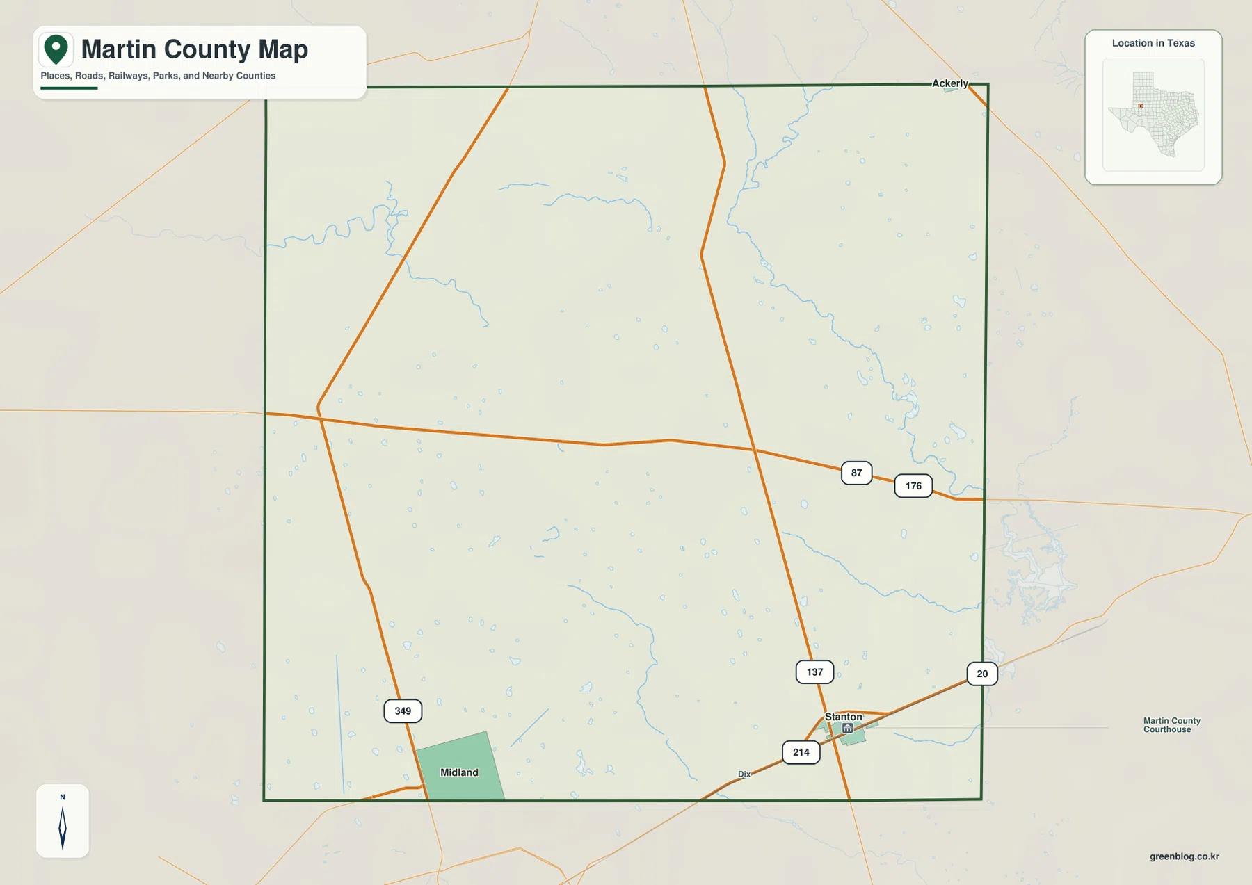
The general map gives Stanton the strongest settlement label inside Martin County. The town is shown close to the southern side with a courthouse symbol nearby. Route 137 runs through the area and continues north, while Route 214 approaches from the southwest. These two road labels make Stanton easy to locate even before smaller geographic details are considered.
North of Stanton, roads 87 and 176 cross the central portion of the county on an east-west line. They provide a useful middle reference between the southern county seat and Ackerly in the northeast. Route 349 is labeled on the western side, while Route 20 appears near the eastern boundary. Because Martin County has few large settlement labels on this map, the numbered roads are unusually important for understanding where a feature sits inside the county.
Ackerly is marked at the northeastern edge rather than near the county center. The gap between Ackerly and Stanton makes the county’s vertical scale immediately visible. Midland is labeled outside the southwestern side as a regional reference, but it is not treated here as a Martin County community. The map therefore reads less like a chain of towns and more like a broad rural area organized around a small number of settlements and long road corridors.
The city index makes the Stanton–Ackerly separation easy to see
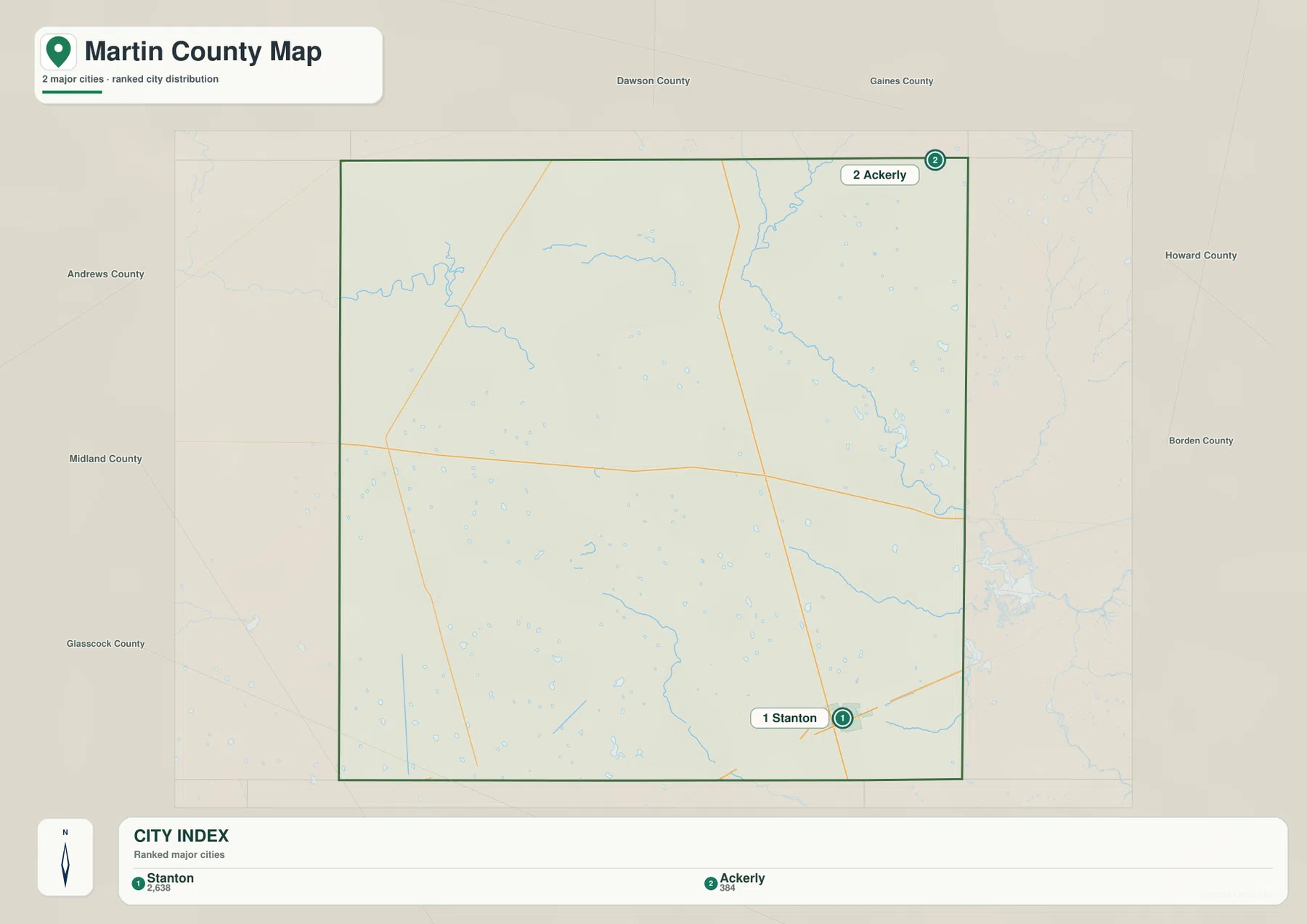
The city map ranks Stanton first and Ackerly second. The lower index also prints the values 2,638 and 384 beside the two names. The supplied image does not identify a year for those numbers, so this article treats them only as values shown on the map rather than presenting them as confirmed current population counts.
The two markers occupy very different parts of the county. Stanton is near the south-central edge, while Ackerly is at the northeast corner. Removing most road and place labels makes the large space between them more obvious. The general map then adds the missing detail: Route 137 and the east-west 87/176 corridor provide some of the main references across that open interior.
Dawson and Gaines counties are labeled north of Martin County, Andrews and Midland counties to the west, Howard and Borden counties to the east, and Glasscock County toward the southwest. These surrounding names help with regional orientation. The city map itself, however, is most useful for the simple contrast between the southern Stanton area and the northeastern Ackerly marker.
Alkali Lake and Sulphur Springs Draw provide the clearest named water references
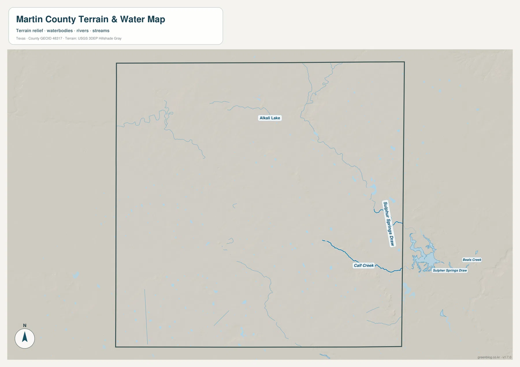
The terrain-and-water map brings forward features that are easy to overlook on the road map. Alkali Lake is labeled in the northern interior, surrounded by smaller pale-blue water marks and thin drainage lines. With the highway layer removed, the scattered water features across the central and western parts of the county become easier to compare.
Sulphur Springs Draw is the strongest named drainage on the eastern side. It follows a mostly north-south course before bending through the lower eastern portion. Calf Creek approaches from the west and joins the same low corridor, while Beals Creek is labeled farther east beyond the county boundary. These names provide direct landmarks for the deeper terrain visible on the elevation map.
A long winding drainage is also visible across the northwest, while smaller unnamed water bodies and channels are scattered through the interior. The supplied image does not label every one of those features, so this article does not assign names that are not visible. The important contrast is geographic: the east contains a more pronounced connected drainage corridor, while much of the western half shows smaller, more isolated water marks.
This layer is intended for geographic reference. It can be used to locate Alkali Lake, Sulphur Springs Draw, Calf Creek, Beals Creek, and visible channels relative to the county boundary, but it is not a flood-hazard map, legal water-boundary map, parcel map, or navigation chart. For road numbers and town locations, match the same area back to the general map.
The broad western upland drops sharply toward lower eastern terrain
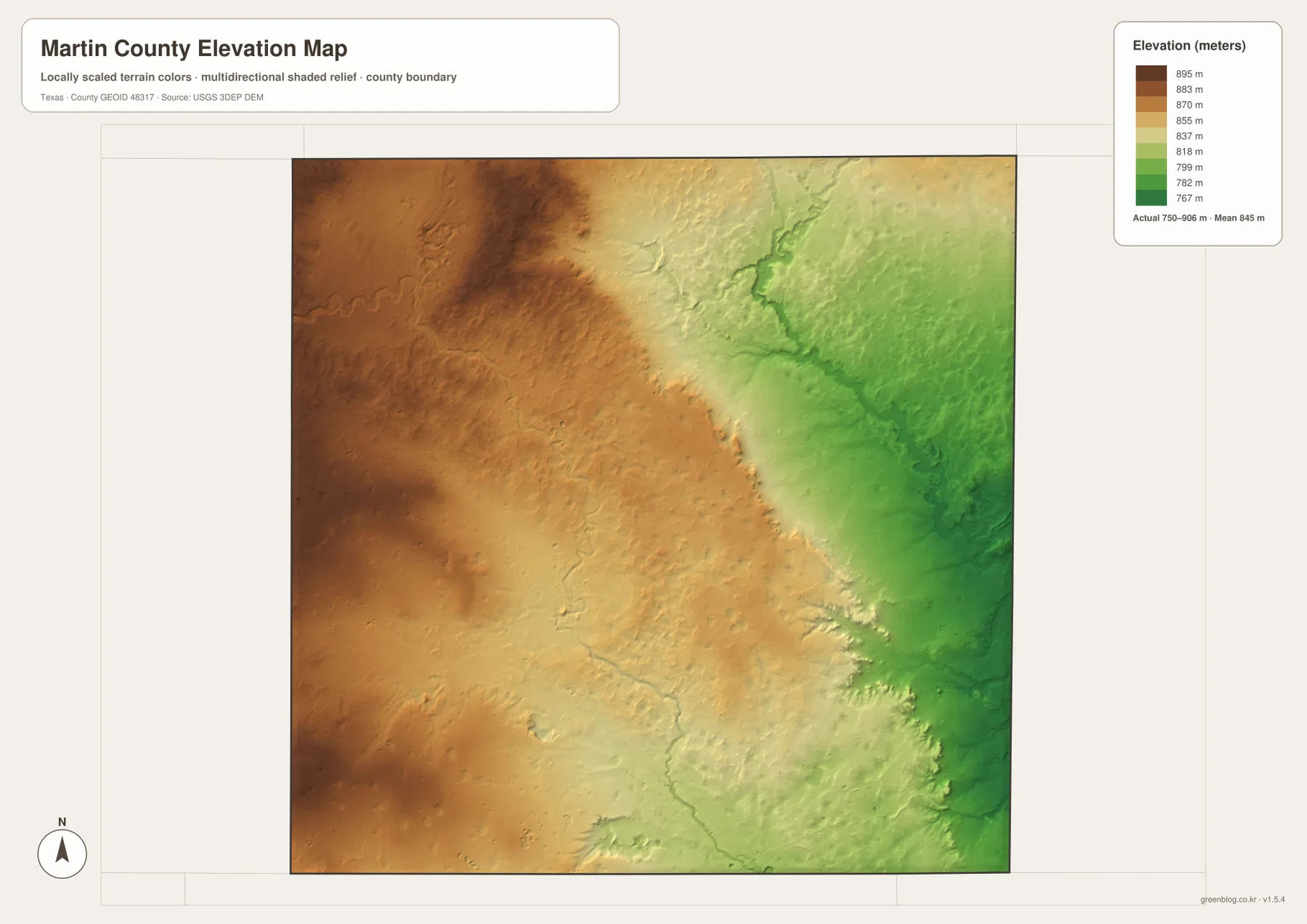
The elevation map reports an actual range of about 750 to 906 meters and a mean elevation of about 845 meters. Dark browns cover much of the west and northwest, showing the county’s higher ground. Colors transition through tan and yellow across the middle and become green over the eastern side, where the lowest broad terrain is concentrated.
The most striking feature is not simply a gentle west-to-east slope. Across the central-eastern part of the county, the map shows a long zone where elevation falls more quickly. East of that break, valleys are more deeply cut and branching drainage becomes much more visible. The northeastern watercourse and the Sulphur Springs Draw–Calf Creek area occupy some of those lower corridors.
The difference between the displayed minimum and maximum elevation is about 156 meters. That range does not indicate a high mountain landscape, but it produces a strong contrast between the broad western surface and the lower, more dissected east. Stanton lies near the southern part of the transition area, while Ackerly is close to the northeastern edge where lower terrain and drainage become more apparent.
The elevation image is best used for relative terrain comparison rather than survey-grade or engineering-grade measurement. It is especially helpful when paired with the water map because the named draws and creeks occupy many of the lowest green corridors. When paired with the road map, it shows why a county that looks simple in highway form has a much more varied physical surface.
Following the county east from Stanton connects the road and terrain views
Begin at Stanton on the general map and trace Route 137 north toward the 87 and 176 corridor. The road view is broad and relatively uncluttered. On the water map, moving farther east brings Sulphur Springs Draw and Calf Creek into view. The elevation map shows the same direction changing from tan higher ground to greener lower terrain, making the eastward drop much easier to understand.
Ackerly provides a second comparison point. On the city map it is simply the small northeastern marker, but the other layers show a different setting from Stanton. Nearby drainage is more pronounced, and the elevation surface is generally lower than much of the western county. The contrast between the two communities is therefore not only about distance; they also sit near different parts of the county’s larger relief pattern.
Use the ranked city map when the Stanton–Ackerly separation is the main question, the general map when numbered roads matter, the terrain-and-water map for named draws, creeks, and Alkali Lake, and the elevation map for the high-west/low-east contrast. Small road labels and drainage names are often easier to inspect in the downloadable high-resolution JPG files than in the browser previews.
Frequently Asked Questions
Which communities are ranked on the Martin County city map?
The map ranks Stanton first and Ackerly second. Stanton is near the south-central edge, while Ackerly sits at the northeastern boundary. The index also prints 2,638 and 384, but no year is shown, so this article does not present those values as confirmed current population counts.
Which named water features are easiest to identify?
Alkali Lake is labeled in the northern interior, while Sulphur Springs Draw is the strongest named eastern drainage. Calf Creek approaches that lower corridor from the west, and Beals Creek is labeled beyond the eastern county boundary.
What elevation range is shown for Martin County?
The supplied elevation map reports an actual range of about 750 to 906 meters and a mean of about 845 meters. The west and northwest are generally higher, while the eastern side contains lower and more deeply cut drainage terrain.
Sources and Reference Data
- U.S. Census Bureau TIGER/Line Shapefiles — official county-boundary and road geometry for geographic reference.
- USGS National Hydrography — official resources for lakes, draws, creeks, and other water features.
- USGS 3D Elevation Program — official elevation resources used for terrain information.
- USGS The National Map Viewer — an official viewer for comparing geographic layers.
Map File Information
Download four high-resolution A3 JPG maps of Martin County, Texas, in one ZIP file.
- Included Files: county map, ranked city map, terrain and water map, elevation map
- File Type: JPG
Related Maps
- Andrews County Texas map
- Terry County Texas map
- Yoakum County Texas map
- Reagan County Texas map
- Sterling County Texas map
Green Map creates custom-edited map images using open geographic data sources such as geoBoundaries, Natural Earth, OpenStreetMap, and government open data.
These maps are edited visual materials, not raw data files, and are provided for education, documents, presentations, and graphic reference.