This page uses Plains as the central reference for a Yoakum County Map, then follows route 214 south toward Denver City and compares that simple two-city pattern with Sulphur Springs Draw and the county’s west-to-east elevation change. Download the high-resolution A3 JPG map ZIP from the box below when you need printable or editable files; it contains separate county-reference, ranked-city, terrain-and-water, and elevation maps.
Yoakum County is sparse on the settlement map. Plains sits near the middle, Denver City is close to the southern edge, and most of the land between and around them contains far fewer place labels. The road map is dominated by long straight segments, but the terrain layers reveal more variation than the simple grid suggests. Higher land occupies the west and northwest, lower terrain spreads across the east and southeast, and Sulphur Springs Draw follows one of the clearest lower corridors through the county.
Table of Contents
Plains is the central road reference, with Denver City to the south
Plains is the easiest place to locate first on the county reference map. Route 214 runs south from the Plains area toward Denver City and provides the clearest north-south relationship between the two main settlements. Around Plains, route shields 380, 220, and 225 provide additional local references, while route 82 approaches from the southwest side.
Denver City lies near the southern county boundary along the same route 214 direction. Route markers 83 and 390 appear around the southern side, while the southeastern road network includes 14, 213, and 330. Away from the two cities, settlement labels become scarce, so long road segments and shallow drainage lines become the most useful clues for orientation.
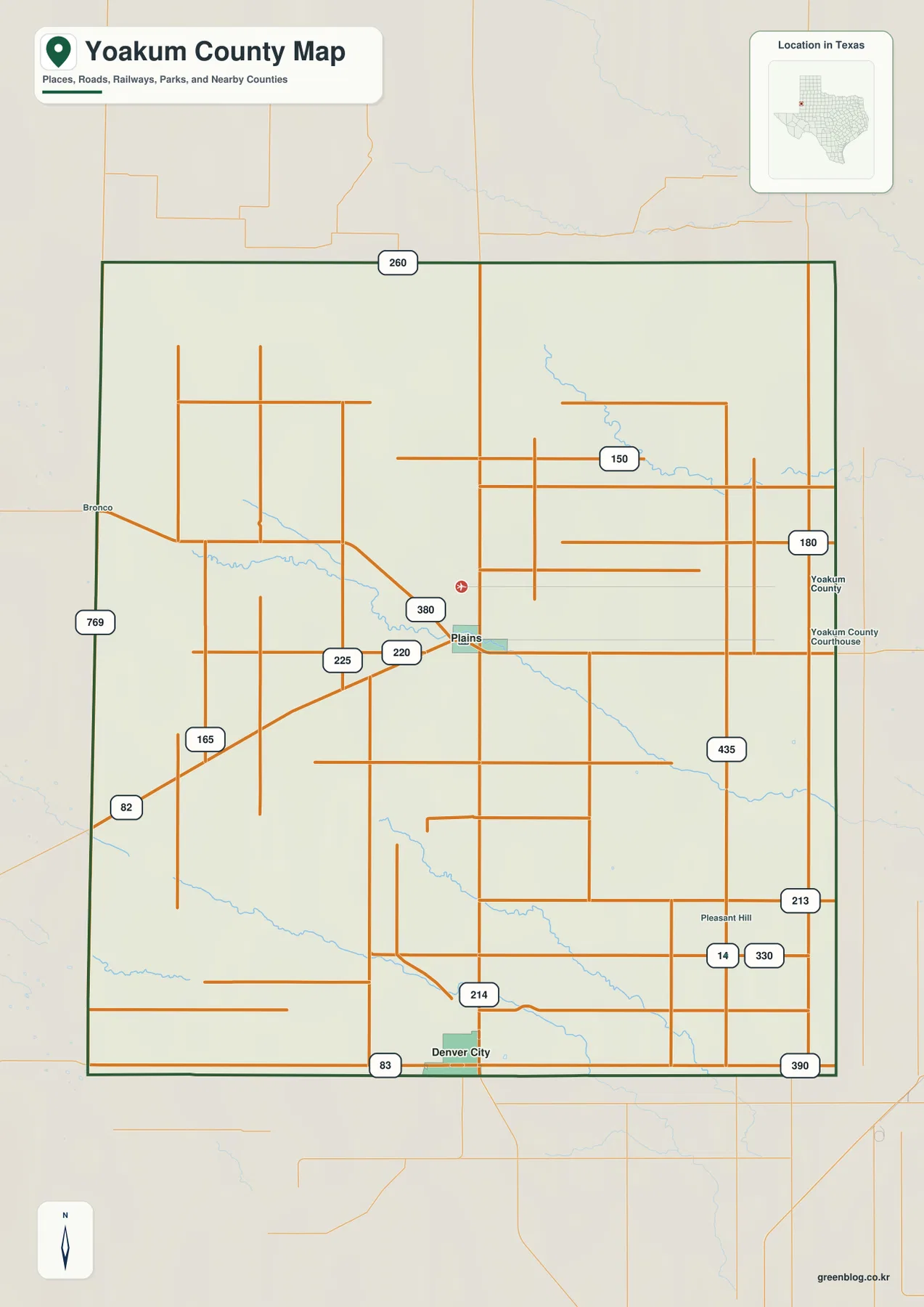
East of Plains, route 150 and route 180 follow long straight alignments, and route 435 appears farther southeast. Small blue channels cross some of these road grids, but named surface-water features are limited. The full reference map therefore works best when Plains and Denver City are used as the first anchors, followed by the major road directions and the few visible drainage corridors.
Denver City ranks first at 4,368, with Plains second at 1,235
The ranked-city layer strips the county down to two major mapped places. Denver City is number 1 near the southern edge, while Plains is number 2 near the center. With most road labels removed, the view makes the large amount of open space surrounding both communities especially clear.
The CITY INDEX prints map values of 4,368 for Denver City and 1,235 for Plains. Those figures explain the ranking and relative symbol sizes used in the supplied graphic and should be treated as map values rather than guaranteed current population estimates. For geographic reading, the important point is that Denver City is the larger southern settlement while Plains remains the central reference for the county.
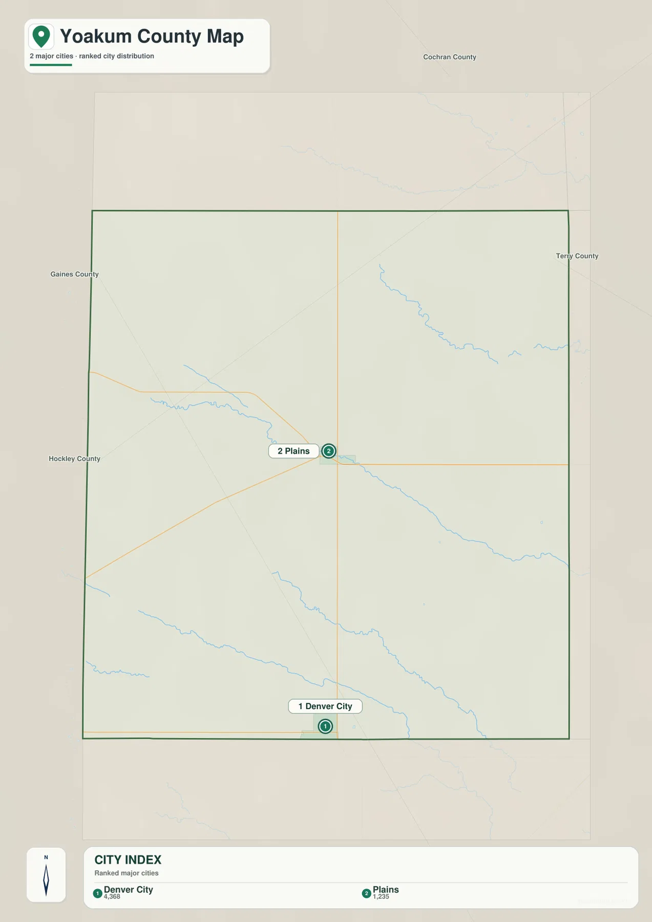
The city layer also shows why route 214 is such a useful orientation line. Plains and Denver City sit in a clear north-south relationship, while the broad eastern and western areas contain no competing ranked-city symbols. That simplicity makes it easier to connect the settlement map with the drainage and elevation layers.
Sulphur Springs Draw is the clearest named water feature
The terrain-and-water map labels Sulphur Springs Draw as the main named drainage feature. It curves from the west-central interior toward the east-southeast and reaches the eastern county edge. Several additional blue channels appear in the north and south, but the supplied map does not label them with river, creek, or lake names.
That limited labeling is important. An unlabeled blue channel should not be assigned a name simply because a regional drainage feature is known from another source. This article therefore uses Sulphur Springs Draw as the verified water reference and describes the remaining channels only by their visible locations and directions.
The north-eastern channel descends through the upper half of the county, while two long shallow drainages cross the southern half in roughly parallel directions. None forms a large lake or dominant river corridor. Compared with counties that have extensive named hydrography, Yoakum County’s supplied water layer is notable for sparse surface-water detail and one especially clear draw.
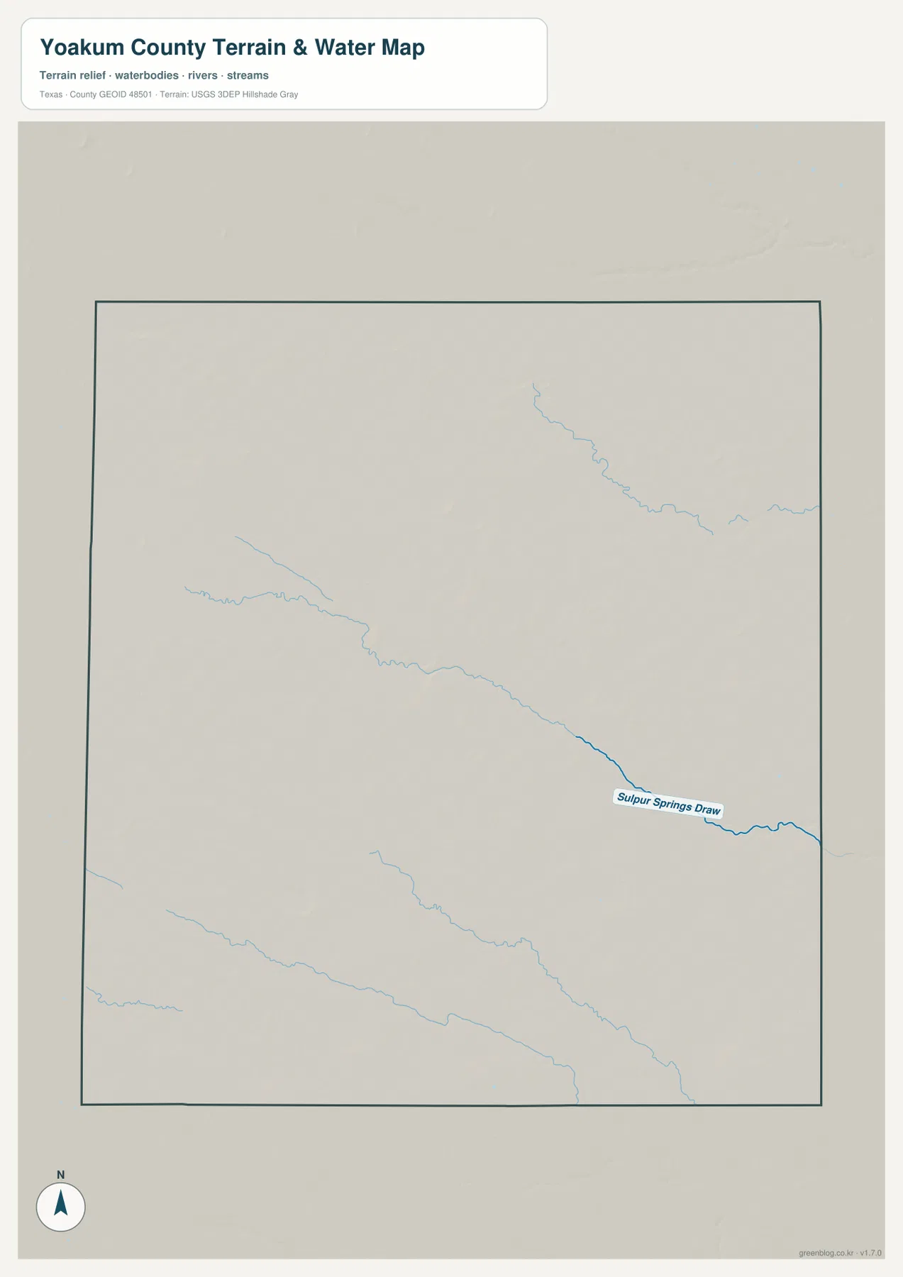
This layer is intended for geographic reference rather than flood-risk analysis, groundwater assessment, water depth, parcel boundaries, or current channel-management decisions. Its main value here is to show where Sulphur Springs Draw crosses the county and how the few other mapped channels occupy lower terrain.
Elevation falls from 1,187-meter western ground toward the east and southeast
The elevation map reports an actual range of about 1,036 to 1,187 meters and a mean elevation of 1,114 meters. The darkest brown high ground occupies much of the west and northwest, while the central area shifts through tan and yellow-green. Broad green lower terrain dominates the east and southeast.
Sulphur Springs Draw creates a clear lower corridor across the middle of the map. The other visible channels also follow green depressions within the broader slope. Although the county shows a strong west-to-east decrease in elevation, the surface is not perfectly smooth; small depressions, shallow ridges, and subtle relief changes remain visible across the High Plains surface.
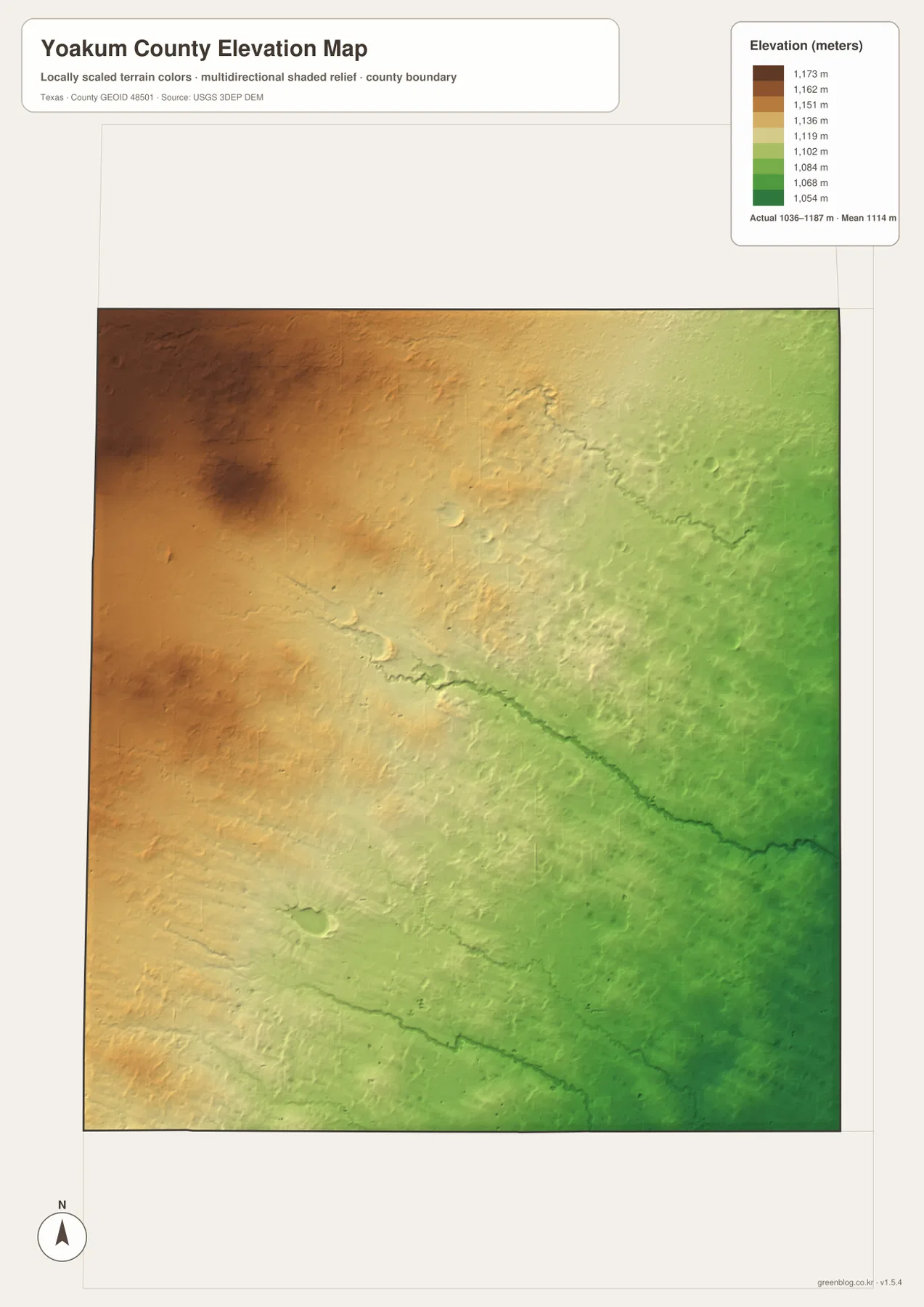
This countywide elevation surface is designed for broad terrain comparison rather than parcel surveying, engineering, or construction design. It is useful for seeing why the western side stands higher, how Sulphur Springs Draw occupies a lower path, and where the surface drops toward the eastern and southeastern edges. Exact elevation at a specific site should be checked with detailed source data or a local survey.
Choose the layer by whether roads, two-city spacing, drainage, or relief matters most
Use the county reference map when Plains, Denver City, route 214, and the wider road network need to appear together. The ranked-city view is cleaner for comparing the two main settlements. The terrain-and-water layer is the best place to locate Sulphur Springs Draw and the few additional channels, while the elevation map makes the higher west and lower east easiest to compare.
The downloadable ZIP contains four separate high-resolution A3 JPG files for Yoakum County: county reference, ranked city, terrain and water, and elevation. You can inspect the lighter WebP versions in the article first and then use the larger JPG files for printing, classroom material, presentations, or an editable local-reference document.
Frequently Asked Questions
Where is Denver City compared with Plains?
Denver City is south of Plains on the supplied maps. Route 214 provides the clearest north-south road reference between the two communities.
What is the clearest named water feature in Yoakum County?
Sulphur Springs Draw is the main named drainage feature on the supplied terrain-and-water map. It crosses the central part of the county toward the east and also appears as a lower corridor on the elevation layer.
What elevation range is shown for Yoakum County?
The supplied elevation map states an actual range of about 1,036 to 1,187 meters and a mean elevation of 1,114 meters. The west and northwest are higher, while the east and southeast are lower.
Map File Information
The ZIP contains the four Yoakum County maps in high-resolution A3 JPG format.
- Included Versions: County reference, ranked city, terrain and water, elevation
- Included Files: 4 A3 JPG maps
Related Maps
Sources and data references
Roads, settlement locations, and the Yoakum County boundary can be cross-checked with the U.S. Census Bureau TIGER/Line Shapefiles. Sulphur Springs Draw and the other visible drainage features can be compared with USGS National Hydrography, while terrain height data are available through the USGS 3D Elevation Program. City index values, route references, named drainage, and the 1,036–1,187 meter elevation range described above are based on the Yoakum County maps supplied in this package.
Green Map creates custom-edited map images using open geographic data sources such as geoBoundaries, Natural Earth, OpenStreetMap, and government open data.
These maps are edited visual materials, not raw data files, and are provided for education, documents, presentations, and graphic reference.