If you need a Young County Map for printing, a presentation, classroom work, or offline reference, you can download the high-resolution A3 JPG map set from this page as one ZIP file. The maps show Graham, Olney, Newcastle, and Loving together with major roads, the Brazos River system, local lakes and creeks, and the county’s changes in elevation. Graham provides the clearest starting point for orientation, while the other communities show how settlement is spread across different parts of Young County.
The maps are most useful when viewed together. The general map shows where roads and communities sit inside the county boundary. The city map simplifies the relationship between Graham, Olney, and Newcastle. The water map shifts attention to the Brazos system, local creeks, and several lakes, while the elevation map shows that Young County is not a uniformly flat surface. By moving between these views, a reader can understand both the human geography and the terrain without relying on a long list of place names.
Table of Contents
Young County at a glance from Graham
Graham appears in the southeastern part of the county map and works well as the starting point for orientation. Olney is well to the north, Newcastle lies northwest of Graham, and Loving is farther to the northeast. This arrangement immediately shows why a single centered dot would not explain the county very well. Each community marks a different portion of Young County, and the roads between them make the overall layout easier to understand. The county map also includes smaller streams and the surrounding road network, so it is useful for seeing how developed places fit into a more heavily dissected rural landscape.
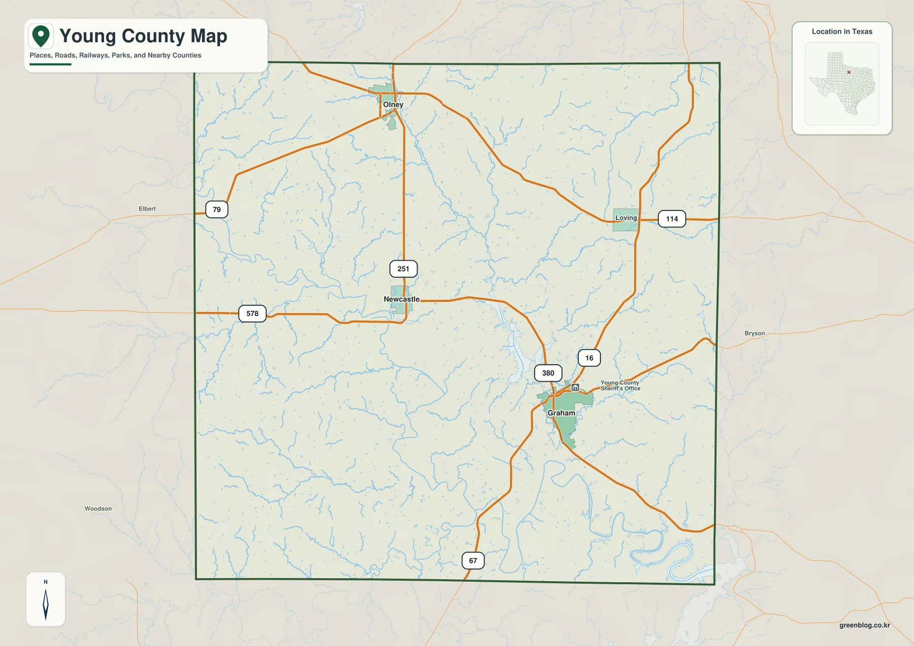
The road pattern is especially clear around Graham. U.S. 380 crosses the city and continues across the county, while State Highway 16 runs through Graham on a north-south line. Other numbered routes appear toward Olney, Loving, the western side of the county, and the southern edge. The map includes 79, 114, 251, 578, and 67 in addition to U.S. 380 and Highway 16. These labels make the page useful for regional orientation because they show not only where a town sits, but also which direction a traveler would generally follow to reach another part of the county.
How Graham, Olney, and Newcastle relate
The city-connections map removes much of the background detail and focuses on three communities. Graham is marked as the hub, with Olney about 21 miles away by the map’s direct-distance label and Newcastle about 12 miles away. Olney lies north of Graham, while Newcastle is northwest of the county seat. Those different directions matter: they show that the two smaller communities do not form a single corridor extending from Graham. Instead, they represent separate parts of the county, which is helpful when explaining local geography to someone who has never visited the area.
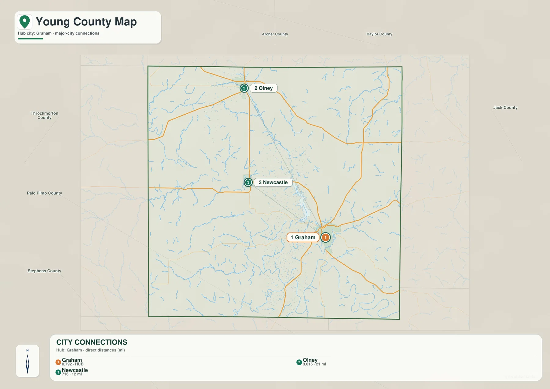
Names of neighboring counties are also placed around the outside of the city map. That extra context helps with questions that go beyond the county line, such as which side of Young County faces another county or how a route continues after leaving the mapped area. The boundary is clear enough to keep the reader oriented, but the road lines do not stop visually at the edge, so the map still conveys regional continuity. For a presentation or report, this is a useful middle ground between a detailed highway map and a bare county-outline graphic.
Roads that organize travel across the county
Graham has the densest road junction on the map. U.S. 380 provides the most obvious east-west connection through the city, and State Highway 16 gives a strong north-south route. A road numbered 67 approaches from the south, while other routes branch toward the north and east. Olney is served by the northward network that includes 251, and Loving sits near 114 on the eastern side. On the west, 79 and 578 help define additional approaches. The result is a map in which the county seat is important, but several roads also link the outer communities directly to neighboring areas.
This makes the general map useful for more than locating towns. It can answer simple orientation questions such as whether Olney and Newcastle are on the same side of Graham, where Loving sits relative to U.S. 380, or which major numbered road reaches the southern part of the county. It is not intended to replace turn-by-turn navigation, and road conditions can change, but it works well as a stable reference for the county’s larger travel pattern. Teachers, writers, and local-history researchers can also use the road network to explain why different communities occupy distinct parts of Young County.
The Brazos system, creeks, and local lakes
The terrain-and-water map changes the emphasis completely. Thick blue lines identify the Brazos River and the Clear Fork Brazos River in the southern portion of the mapped area, while a dense network of smaller tributaries spreads across the county. Labeled examples include Salt Creek, Little Salt Creek, Brushy Creek, Briar Creek, Flint Creek, Fish Creek, and Willow Pond Creek. Seeing these channels together makes it clear that Young County contains many branching drainages rather than only one prominent river corridor. The smaller creeks are particularly useful for understanding how water reaches the larger Brazos system.
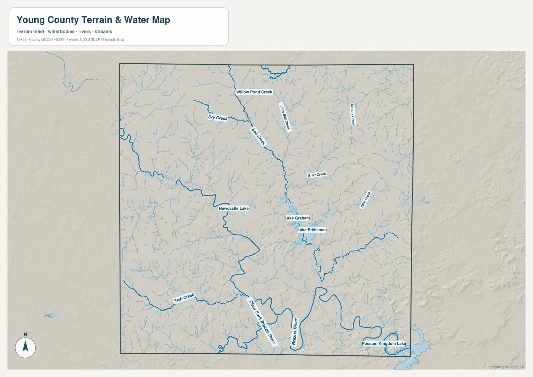
Several lakes provide additional landmarks. Lake Graham and Lake Eddleman appear close together near Graham, Newcastle Lake is farther to the west near Newcastle, and Possum Kingdom Lake reaches the southeastern edge of the mapped area. These water bodies are useful reference points because they connect familiar place names to the drainage network. Lake Graham and Lake Eddleman help orient the area around the county seat, while Possum Kingdom Lake is tied visually to the larger Brazos corridor. The map is best used for geographic context rather than boating or fishing regulations, but it gives a clear picture of where the major named waters sit.
The water map also reveals why road and city maps alone tell only part of the story. Numerous creeks run between the communities, and the larger river channels occupy low corridors that are not obvious on the road map. A reader comparing the two can see that the county’s travel routes and settlements exist within a landscape cut by many small drainages. This is helpful for general environmental context, historical research, or any project that needs to explain where Graham and the surrounding communities sit in relation to the Brazos watershed.
Elevation from river valleys to higher ridges
The elevation map shows an actual mapped range of roughly 303 to 459 meters, with a mean value of about 355 meters. Greens represent the lower ground, while tan and brown areas mark higher terrain. The contrast is strong enough to show that Young County is made up of river valleys, rolling uplands, and repeated ridges rather than a smooth plain. Lower zones follow the major drainage corridors in the southern and central portions of the map, while higher ground appears around several outer and interstream areas.
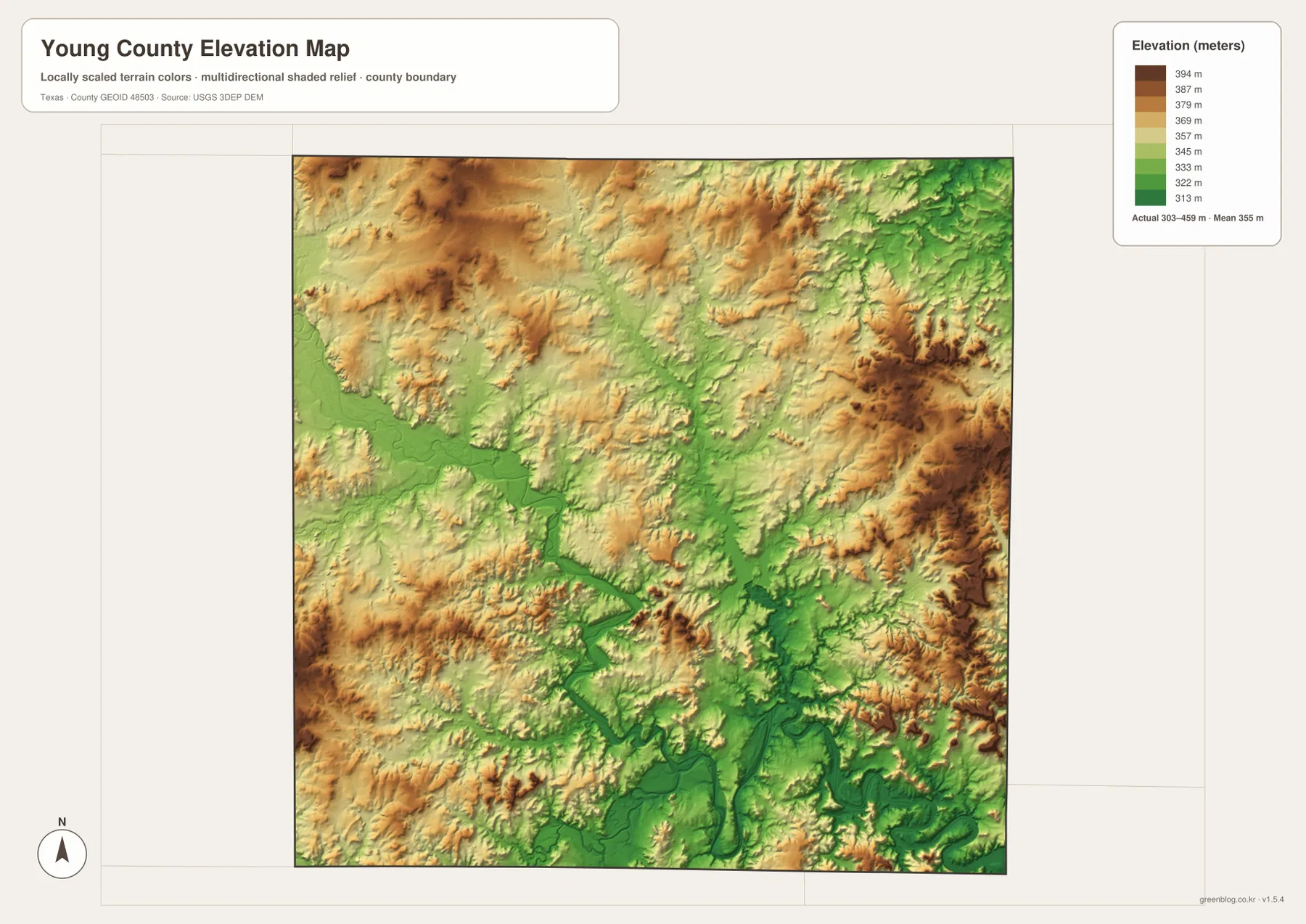
When this image is compared with the water map, the relationship between topography and drainage becomes easier to see. The Brazos River and its major tributaries occupy lower green corridors, and higher ridges rise between many of the drainage branches. The map does not provide a detailed contour survey for a specific parcel, so it should not be used for engineering or property-level elevation decisions. Its strength is broader: it quickly shows which parts of the county are relatively low, where the terrain rises, and why the river network follows the routes it does.
Choosing the best map for your purpose
For a first look at Young County, start with the general county map. It combines the boundary, Graham, Olney, Newcastle, Loving, numbered highways, and many streams in one view. If the main question is how the larger communities relate to Graham, the city-connections map is cleaner because it reduces the amount of background information and emphasizes direction and distance. The terrain-and-water map is the better choice for the Brazos River, named creeks, and lakes. The elevation map is most useful when the subject is relief, river valleys, or the difference between lower and higher terrain.
Using two maps together can often explain the county better than using one alone. A classroom lesson might pair the county map with the elevation map to show where towns and highways sit in relation to the terrain. A water-focused report could use the county map first, then the terrain-and-water map to highlight Lake Graham, Lake Eddleman, Newcastle Lake, Possum Kingdom Lake, and the Brazos system. For print layouts or image editing, the downloadable JPG files are more convenient than copying the web previews because they are supplied as high-resolution A3 map files.
Frequently Asked Questions
Where is Graham on the Young County map?
Graham appears in the southeastern part of the county and is the main road hub on the map. U.S. 380 and State Highway 16 pass through the city, while Olney lies to the north and Newcastle to the northwest. Using Graham as the reference point makes the positions of the other mapped communities easier to understand.
Which rivers and lakes are shown in Young County?
The water map labels the Brazos River, Clear Fork Brazos River, several named creeks, Lake Graham, Lake Eddleman, Newcastle Lake, and Possum Kingdom Lake. The smaller creeks branch across the county and connect visually with the larger river system, making the map useful for understanding regional drainage.
What elevation range does the Young County elevation map show?
The map shows an actual elevation range of about 303 to 459 meters and a mean of roughly 355 meters. Lower green areas generally follow major drainage corridors, while tan and brown areas identify higher ridges and uplands. It is intended for county-scale comparison rather than parcel-level surveying.
Sources and reference data
The article is based on the supplied Young County map assets and the features visible in those maps. For official background on boundary, hydrography, and elevation datasets used in U.S. mapping, the following federal sources provide the relevant data frameworks.
- Young County, Texas official website – official county information and county-seat reference for Graham
- Handbook of Texas: Young County – background on the county’s location and regional history
- U.S. Census Bureau TIGER/Line Shapefiles – official geographic files for boundaries, roads, and related features
- USGS National Hydrography – federal hydrography information for rivers, streams, and water bodies
- USGS 3D Elevation Program – official U.S. elevation data and terrain resources
Map File Information
The ZIP contains high-resolution A3 JPG versions of the Young County general map, city map, terrain-and-water map, and elevation map. They are suitable for printing, document layouts, presentations, offline reference, and image editing.
- File Type: ZIP containing four JPG files
Related Maps
Green Map creates custom-edited map images using open geographic data sources such as geoBoundaries, Natural Earth, OpenStreetMap, and government open data.
These maps are edited visual materials, not raw data files, and are provided for education, documents, presentations, and graphic reference.