Putnam County sits in central Georgia around Eatonton, where several major highways meet before the county opens toward large reservoirs and river valleys on the east and south. This page combines a county map, a ranked city map, a water map, and an elevation map so you can compare roads, settlement, drainage, and terrain without treating them as separate subjects. Four high-resolution A3 JPG maps are available together in one ZIP from the map file box near the top of the page, while the WebP images below provide lighter previews for quick reference.
Table of Contents
Eatonton at the center of Putnam County’s road network
The general county map makes Eatonton the easiest place to use as an orientation point. Routes 24, 129, and 441 run through or near the city on a north–south path, while Route 16 heads east across the county. Route 142 approaches the western side, and Routes 44 and 212 are labeled in the southern and southwestern part of the map. Seen together, these roads form a clear hub-and-spoke pattern around Eatonton rather than a county dominated by one single cross-county highway.
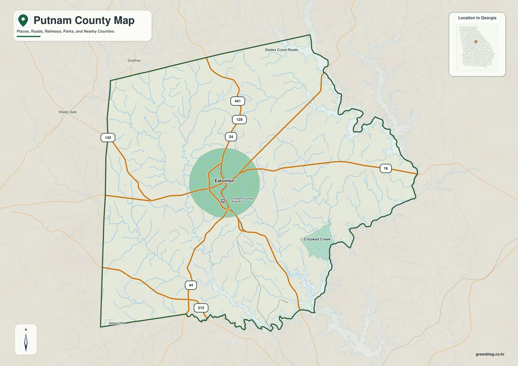
The outline of the county is also worth noticing. The western edge is comparatively straight, while the eastern and southern sides are much more irregular. That irregularity becomes easier to understand when the water map is viewed later: reservoirs, river channels, and narrow inlets help shape much of the boundary on those sides. Smaller labels such as Glades Cross-Roads in the north and Crooked Creek in the southeast add useful local reference points without turning the map into a street-level directory.
This map is best used for county-scale orientation. It shows where the main roads and selected places sit in relation to the county line, but it does not attempt to show every local road, parcel, subdivision, or service address. For a reader coming from another part of Georgia, the combination of the county outline and highway numbers provides enough structure to understand how Eatonton connects to the rest of Putnam County.
A city map with one dominant center: Eatonton
The ranked city map lists only one major city: Eatonton. Its marker sits near the middle of the county, slightly toward the west, and the city index at the bottom identifies Eatonton as the single ranked urban center in this dataset. That makes the map unusually simple compared with counties that contain several incorporated cities of similar prominence. Instead of asking which towns form a chain or cluster, the more useful question here is how the rest of the county is arranged around Eatonton.
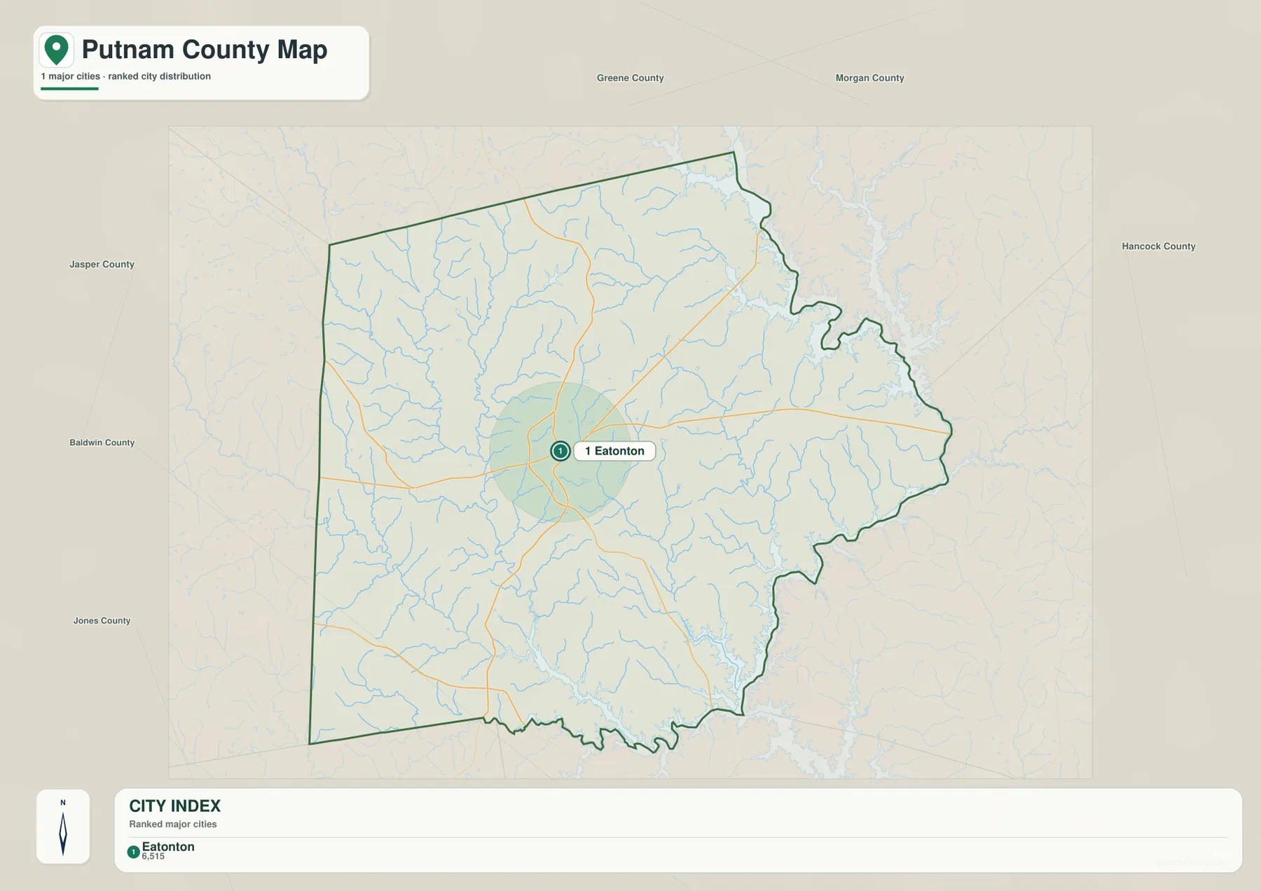
The surrounding county names provide additional orientation. Greene, Morgan, Hancock, Baldwin, Jones, and Jasper Counties are labeled outside the Putnam boundary, showing how Putnam fits into the central Georgia county pattern. The city map also keeps the road network and drainage in the background, so Eatonton can be understood not as an isolated dot but as a place connected to the western land boundary and to lake country farther east.
Eatonton is also the county seat, which helps explain why it is the strongest civic reference point on the map. Existing county background material notes Putnam County’s literary history and the importance of the Lake Oconee area, but the city map itself stays focused on settlement location. Readers looking for neighborhoods, unincorporated communities, or detailed municipal limits would need a more specialized local map.
Lake Oconee, Lake Sinclair, and the creeks that feed the river system
Water is the strongest natural feature on the eastern and southern sides of Putnam County. Lake Oconee occupies a broad, highly indented area along the northeast, while Lake Sinclair appears along the southern edge. Between them, the Oconee River is labeled in the southeast. The reservoir shorelines create long fingers and coves that are barely visible on the road map but become a defining part of the county’s shape on the terrain-and-water map.
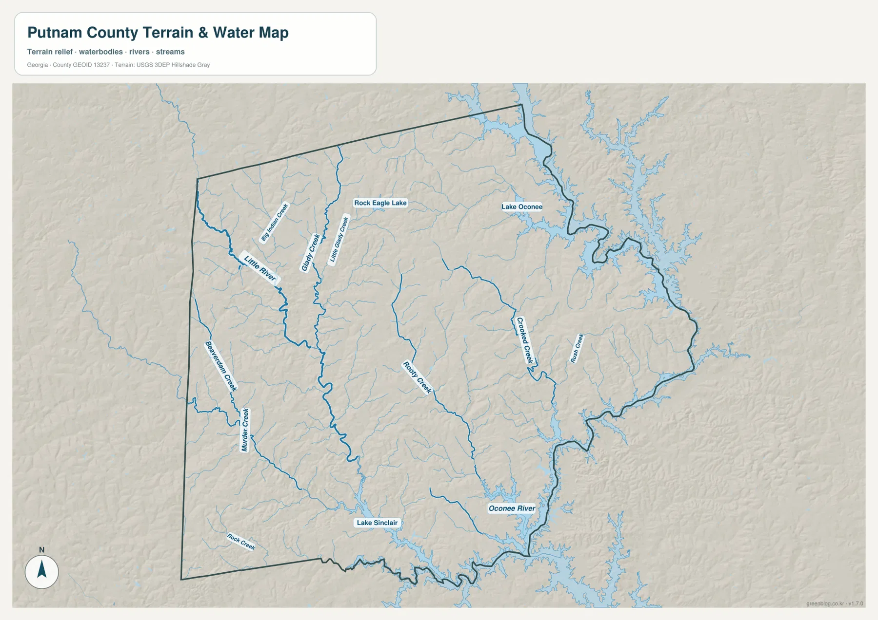
The northwest contains another important drainage line: the Little River. Big Indian Creek, Long Dry Creek, and Little Glady Creek are labeled nearby, while Rooty Creek runs through the central part of the county. Crooked Creek and Rush Creek appear farther east. In the southwest, Beaverdam Creek, Murder Creek, and Rock Creek are shown, and Rock Eagle Lake is labeled in the northern interior. These names demonstrate how many smaller channels cut across the county before joining larger rivers or reservoirs.
Looking at the drainage this way is useful because Putnam County is not organized around a single river corridor. Several creek systems descend through rolling ground and eventually connect with the larger lake-and-river system on the east and south. The map is not a flood map and does not provide water depth, boat access, or property-level shoreline information. Its strength is the county-wide view: it shows where water is concentrated and how the named creeks relate to the major reservoirs.
Rolling uplands north and west, lower valleys toward the Oconee
The elevation map shows an actual range of about 103 to 212 meters, with a mean elevation of 148 meters. Browns and tans mark higher ground across much of the north, north-central area, and parts of the west. Greens identify lower terrain, especially along the southeastern river corridor, reservoir margins, and narrow creek valleys. The county is not mountainous, but the shaded relief reveals a dense pattern of ridges separated by stream-cut hollows.
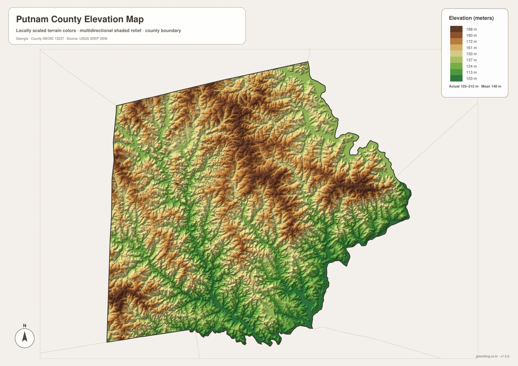
The terrain becomes more informative when compared with the water map. Long green bands often follow the same paths as Little River, Rooty Creek, Crooked Creek, and the Oconee River because stream valleys occupy the lower parts of the landscape. Higher colors sit between those drainages on the intervening ridges. This relationship explains why the shaded surface looks finely divided even though the total elevation range is modest.
For general planning or classroom geography, the elevation map is useful for recognizing broad terrain differences. It should not be treated as a survey, engineering surface, or trail-grade map. The color scale and shaded relief are designed to show relative high and low areas across the county, not precise elevation at an individual building or parcel.
What the four maps reveal when read together
Putnam County becomes much easier to understand when roads, settlement, water, and relief are compared on the same page. Eatonton anchors the interior road network. Route 16 leads east toward lake country, while Routes 24, 129, and 441 provide the strongest north–south references around the county seat. Meanwhile, the largest bodies of water and the lowest terrain collect mainly on the eastern and southern sides, where the county boundary becomes more irregular.
This contrast is especially useful for readers who know one local name but not the county as a whole. Someone familiar with Lake Oconee can use the maps to see that the reservoir lies northeast of Eatonton and connects to a much larger drainage system. Someone starting with Eatonton can follow the highways outward and then switch to the water and elevation maps to see why the eastern edge has a different physical character from the interior uplands.
Each map also serves a different practical need without requiring a technical GIS workflow. The county map is quickest for highways and boundaries, the city map clarifies Eatonton’s role, the water map is best for lakes and named creeks, and the elevation map separates higher ridges from lower valleys. For a report or presentation, choosing the map that matches the subject usually communicates more clearly than trying to place every layer on one image.
Eatonton and lake country in the county’s broader setting
Existing county background material identifies Eatonton as the county seat and notes that Putnam County was established in 1807. It also connects the county with literary history and the Lake Oconee area. Those subjects help explain why Eatonton and the reservoir country are familiar names, but the maps on this page are designed first as geographic references. They show where those places sit, which roads connect them, and how rivers and terrain shape the space between them.
That distinction matters when using the files. A visitor guide might focus on attractions, lodging, marinas, or historic sites; a parcel map would focus on ownership lines; a flood map would show hazard zones. The four county maps here instead provide a consistent county-scale base for location, settlement, water, and elevation. They are most useful when the goal is to understand the physical arrangement of Putnam County before moving to a more specialized source.
Frequently Asked Questions
What is the main city and county seat shown on the Putnam County maps?
Eatonton is the county seat and the only major city ranked on the city-distribution map included in this package. It also sits near the center of the main highway network shown on the general county map.
Where are Lake Oconee and Lake Sinclair in relation to Putnam County?
Lake Oconee is shown along the northeastern side of the county, while Lake Sinclair lies along the southern edge. The Oconee River is labeled between the larger reservoir areas in the southeast.
What is included in the downloadable ZIP?
The ZIP contains four high-resolution A3 JPG files: a county map, city map, water map, and elevation map. The images displayed in the article are WebP previews intended for faster webpage loading.
Map File Information
The download package contains four high-resolution A3 JPG maps of Putnam County: the county map, city map, water map, and elevation map. The page uses WebP previews for faster viewing, while the ZIP provides the larger JPG files for printing or offline reference.
- Included Files: County map, city map, water map, elevation map
Related Maps
Sources and References
The following sources provide official geographic data and background information used to check Putnam County boundaries, water features, elevation, and local context.
- U.S. Census Bureau TIGER/Line Shapefiles – county boundary and transportation reference data
- USGS National Hydrography – rivers, streams, lakes, and related hydrography
- USGS 3D Elevation Program – elevation and terrain data
- U.S. Census Bureau QuickFacts – Putnam County, Georgia
- The New Georgia Encyclopedia – Putnam County – county history and local background
Green Map creates custom-edited map images using open geographic data sources such as geoBoundaries, Natural Earth, OpenStreetMap, and government open data. These maps are edited visual materials, not raw data files, and are provided for education, documents, presentations, and graphic reference.