Decatur County sits in the far southwest corner of Georgia, where Bainbridge, the Flint River, major highways, and the Florida state line provide the clearest reference points. This page brings those features together in four complementary views: a county and road map, a city-connections map, a detailed water map, and an elevation map. The on-page images are WEBP previews, while a single ZIP download provides all four original A3 high-resolution JPG files for saving or printing.
Bainbridge is the easiest place to begin. Brinson lies to the northwest, Climax is east of the county seat, and Attapulgus is southeast toward Florida. The Flint River crosses the county and widens toward Lake Seminole in the southwest, so roads and waterways point in different but equally useful directions. Looking at the four maps together makes the county easier to understand than treating the city labels, river system, and terrain as separate facts.
Table of Contents
Where Decatur County Sits in Southwest Georgia
Decatur County borders Seminole County on the west and Grady County on the east. Miller, Baker, and Mitchell counties form the northern side, while the southern edge meets Gadsden County, Florida. That position makes the county both a southwest Georgia locality and part of a wider cross-state travel area reaching toward Tallahassee, north Florida, and southeast Alabama.
Bainbridge is the county seat and by far the largest incorporated place. The source material for the existing page lists four incorporated cities: Bainbridge, Attapulgus, Brinson, and Climax. Census figures carried in the package report 29,367 residents in 2020 and a July 1, 2025 estimate of 29,432. With 597.24 square miles of land, the county is spacious relative to its population, and the maps show how a substantial share of settlement and road activity is concentrated around Bainbridge.
| State | Georgia |
|---|---|
| County | Decatur County |
| County seat | Bainbridge |
| Created | 1823 |
| Incorporated cities | Bainbridge, Attapulgus, Brinson, Climax |
| 2020 population | 29,367 |
| 2025 population estimate | 29,432 |
| 2020 land area | 597.24 square miles |
| FIPS code | 13087 |
| Download | Four A3 high-resolution JPG maps in one ZIP |
Roads, County Boundary, and the Bainbridge Hub
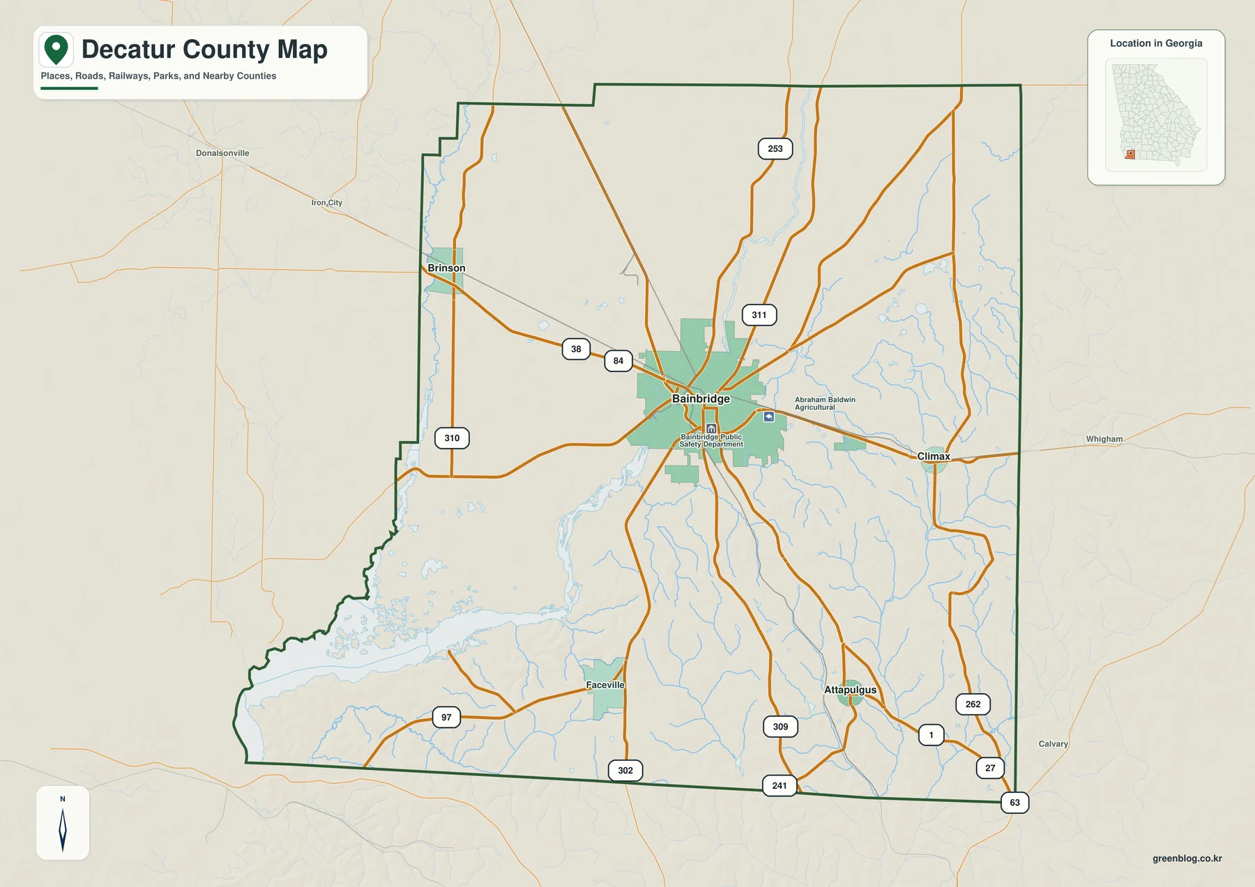
The general county map makes Bainbridge stand out because several routes converge near the city and cross the Flint River. US 84 runs across the county from the Brinson side through Bainbridge toward Climax. US 27 leaves Bainbridge toward Attapulgus and the Florida line. Additional route numbers visible on the map include 38, 97, 241, 253, 262, 302, 309, 310, and 311, giving readers more reference points than a simple outline map.
Bainbridge occupies a south-central position rather than the geographic center of every county feature. Brinson is near the northwestern side, Climax marks the eastern side, and Attapulgus sits well to the southeast. Faceville is also labeled in the southern half, and a dense web of small streams appears east and southeast of Bainbridge. The map is useful for orientation, but it is not a parcel map, a legal municipal-boundary map, or a substitute for current turn-by-turn road information.
City Connections from Bainbridge
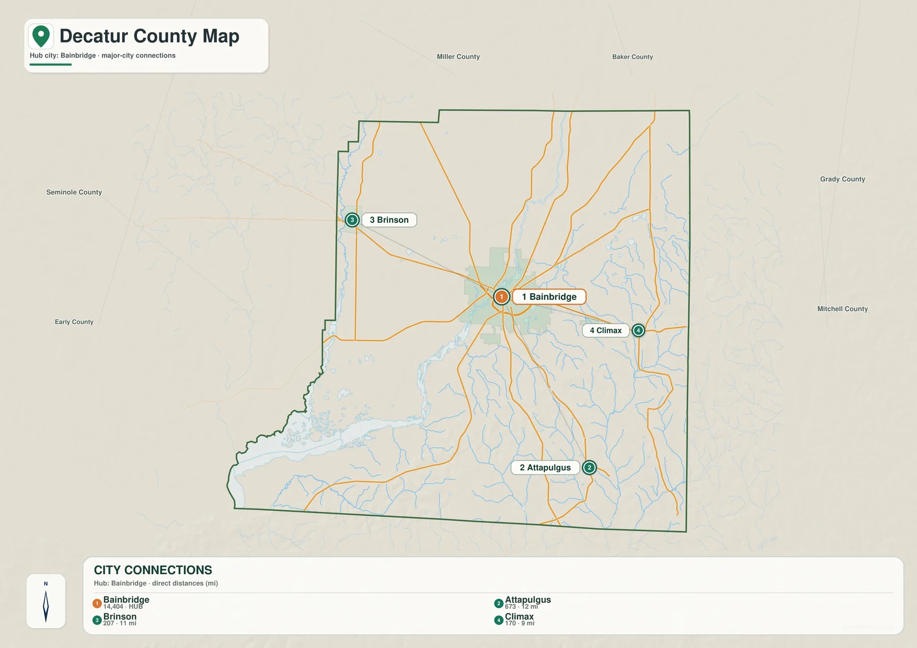
The city-connections map simplifies the county to one hub and three incorporated places. Bainbridge is the orange central marker, Brinson is northwest, Climax is east, and Attapulgus is southeast. This layout is especially helpful when the reader wants to understand direction before looking at a more detailed road or water map.
Distances in the city panel are straight-line distances, not driving distances. They measure direct separation between the city points, so they should not be used to estimate a road trip without checking the actual route. Bridges, road bends, junctions, and the limited places where a driver can cross the Flint River can make the real trip longer than the connector value suggests.
The difference in municipal scale is substantial. The source package lists 2020 populations of 14,468 for Bainbridge, 454 for Attapulgus, 276 for Climax, and 217 for Brinson. Bainbridge therefore functions as the dominant civic and commercial center, while the three smaller cities help define separate corners and travel corridors of the county.
Flint River, Lake Seminole, and the Smaller Waterways
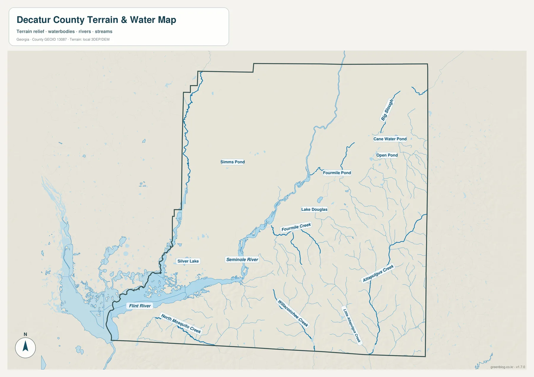
The water map shifts attention away from highways and makes the drainage network much more visible. The Flint River comes down through the county and broadens toward the southwest. Near that lower part of the county, the map labels Seminole River and shows the much wider water area associated with Lake Seminole. Silver Lake also stands out in the southwest interior, while Lake Douglas and several smaller named ponds appear farther east and north.
Named waters on the map include Fourmile Creek, Attapulgus Creek, Willacoochee Creek, Little Attapulgus Creek, and North Mosquito Creek. Ponds labeled Simms Pond, Fourmile Pond, Cane Water Pond, and Open Pond add smaller reference points. The southeastern side contains many short tributaries, so the water map explains why the ordinary county map appears finely lined in that part of Decatur County.
Lake Seminole extends beyond Decatur County and belongs to a larger Georgia–Florida border landscape. Material preserved in the package cites the U.S. Army Corps of Engineers description of a roughly 37,500-acre reservoir with 376 miles of shoreline. The Flint and Chattahoochee rivers meet in the reservoir, and water below Jim Woodruff Dam becomes the Apalachicola River. These facts are useful for regional context, but this map should not be used for boating channels, current water depth, flood risk, or launch decisions.
Elevation from River Lowlands to the Higher Southeast
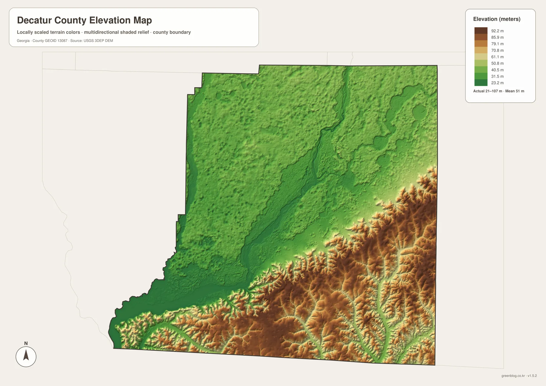
Decatur County is not a mountain county, yet the elevation map shows meaningful local differences. The legend on the supplied preview reports an actual range of about 21 to 107 meters and a mean near 51 meters. Greens dominate the central, northern, and western portions, while the river corridor and the Lake Seminole side are among the lower-looking areas.
A different pattern appears across the southeast and parts of the eastern side, where tan and brown colors mark higher ground. Short ridges and narrow valleys are more visible there than around the broad Flint River lowlands. The contrast is useful because the road map alone does not show why small creeks branch so densely through the southeastern part of the county.
The elevation surface is generalized for county-scale viewing and is based on the USGS 3DEP source identified in the map package. It can show relative highs and lows, but it is not survey-grade elevation for a building site, drainage design, or engineering work. For those tasks, use a current site-specific elevation or survey source.
Why the River and Roads Matter to the County
Georgia created Decatur County in 1823 and named it for naval officer Stephen Decatur. Bainbridge, chosen as the county seat the following year, was named for naval commander William Bainbridge. The similar naval associations can make the two names sound connected, but they honor different people.
The Flint River has long influenced the county’s transportation story. The background material in the package describes nineteenth-century steamboat traffic and landings that handled cotton, timber, and naval stores. Modern Bainbridge still faces the river through its Boat Basin and inland-port facilities. On the map, the city’s location makes sense: major roads meet near a river crossing, while the waterway continues southwest toward a large reservoir.
The 2022 comprehensive plan cited in the supplied material describes roughly 255,000 acres of forest across the county, including large concentrations on both sides of the Flint. Agriculture and forestry occupy broad rural areas around comparatively compact municipalities. This helps explain why the county map shows a strong Bainbridge road cluster surrounded by large stretches with few city labels.
Southern Decatur County also includes the 9,200-acre Silver Lake Wildlife Management Area, with a 350-acre lake, smaller ponds, wetlands, and longleaf-pine habitat. The Attapulgus area has another distinctive feature: deposits of fuller’s earth, an absorbent clay associated with local mineral production. Northwest of Bainbridge, the county airport, industrial park, and a county-owned rail spur add transportation and employment infrastructure outside the downtown core.
Choosing the Right Map for a Project
Use the county overview when the main question is where Bainbridge and the smaller cities sit relative to roads and county edges. Move to the city-connections map when direction and direct separation between the four incorporated places matter more than road detail. The water map is better for named rivers, creeks, lakes, and ponds, while the elevation map explains the broad difference between river lowlands and the higher southeastern terrain.
For a classroom handout, local-history page, or travel-planning reference, combining two maps is often clearer than forcing all information onto one image. A road-and-city discussion works well with the county and city maps. A river or natural-resources discussion is easier to follow with the water and elevation maps together. The maps are designed for geographic orientation and visual comparison rather than legal, engineering, navigation, or emergency decisions.
- Trace US 84 through Brinson, Bainbridge, and Climax.
- Compare the US 27 direction from Bainbridge toward Attapulgus and Florida.
- Follow the Flint River past Bainbridge toward the broad Lake Seminole water area.
- Locate Silver Lake and the named creeks and ponds on the water map.
- Compare lower river terrain with the higher, more textured southeastern part of the elevation map.
The downloadable archive contains four separate A3 high-resolution JPG files: the county overview, city connections, waterways, and elevation. They are provided together in one ZIP so the full set can be saved at once and individual maps can then be selected for printing, teaching, reports, or personal reference.
Frequently Asked Questions
Are Bainbridge, Attapulgus, Brinson, and Climax all incorporated cities?
Yes. The county material supplied for this rewrite identifies all four as incorporated places. The map markers do not draw the exact legal municipal limits, so a boundary-sensitive task should still use an official municipal or county boundary dataset.
Is all of Lake Seminole inside Decatur County?
No. Decatur County reaches the Lake Seminole area in the southwest, but the reservoir extends beyond the county and across the wider Georgia–Florida border region. The water map is intended to show the county’s relationship to the lake, not the complete reservoir jurisdiction.
Can the connector distances or elevation colors be treated as field measurements?
No. The city connectors are straight-line distances between mapped city points, and the elevation layer is a generalized county-scale surface. Use current road routing for travel distance and site-specific survey or engineering data when exact elevation is required.
Map File Information
Get the Decatur County A3 map files
- Included Files: 4 high-resolution A3 JPG map files shown in this article
- File Type: JPG files in a ZIP archive
- Intended Use: Printing, education, presentations, and map-based projects
Related Maps
- A Clinch County Map
- A Columbia County Georgia Map
- Adel and Little River on the Cook County Georgia Map
Sources and References
County statistics and general background can be checked through the U.S. Census Bureau QuickFacts page and the Decatur County official website. For county history and local context, see the New Georgia Encyclopedia and the Georgia DCA Decatur County Comprehensive Plan. Current reservoir information is available from the U.S. Army Corps of Engineers Lake Seminole page, and wildlife-area details are available from Georgia DNR Silver Lake WMA.
Green Map creates custom-edited map images using open geographic data sources such as geoBoundaries, Natural Earth, OpenStreetMap, and government open data. These maps are edited visual materials, not raw data files, and are provided for education, documents, presentations, and graphic reference.