Cook County sits in south Georgia with Adel at the center of a compact chain of towns that follows Interstate 75 and U.S. 41. Lenox and Sparks lie to the north, Cecil is to the south, and a network of creeks and ponds spreads away from that highway corridor toward the Little River and other drainage areas. This page separates those features into county, city, water, and elevation views. For larger use, you can download four high-resolution A3 JPG maps together in one ZIP rather than relying only on the WebP previews shown in the article.
The four-map set is useful because Cook County changes character depending on what you are trying to locate. Roads make the county look strongly north–south, but the water map reveals Brushy Creek, New River, Bear Creek, Morrison Creek, the Little River, and many small ponds running in different directions. The elevation map adds another layer, showing a relatively high northern area and lower ground along the southern and western drainage corridors. Reading those pieces together gives a clearer picture of a county that can look deceptively simple on a basic road map.
Table of Contents
Adel at the center of the I-75 and U.S. 41 road pattern
The county map makes Adel the easiest reference point. Sparks sits just to the north, Lenox farther north, and Cecil south of Adel near the county line. Interstate 75 and U.S. 41/Georgia 7 run through the same broad north–south corridor, so the four incorporated municipalities appear in a nearly linear sequence. Georgia 37 crosses the county east–west at Adel, while Georgia 76 reaches toward the southwest. The courthouse and sheriff’s office are also labeled around Adel, reinforcing its administrative role.
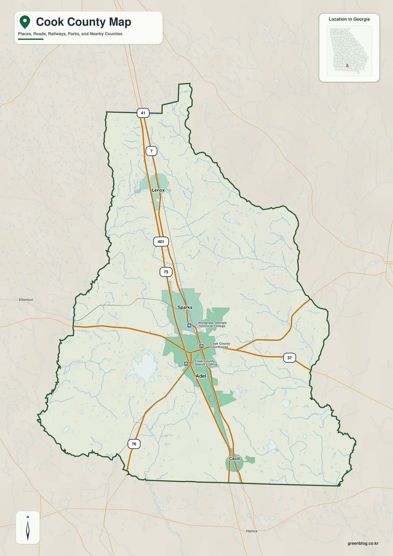
This alignment has practical and historical meaning. The current interstate is the strongest regional route, but the towns were not created by I-75. The verified history preserved in the package notes that Adel grew at a railroad junction and incorporated in 1889, while Cecil, Lenox, and Sparks developed around Georgia Southern railway stops near the turn of the twentieth century. The modern highway therefore follows a settlement corridor whose basic north–south organization is older than the freeway.
Cook County’s July 1, 2025 population estimate is 18,232 in the existing Census material. The 2010 census counted 17,212 people and the 2020 census 17,229, so long-term growth was limited before the more recent increase. The estimates base indicates a 5.8 percent gain from 2020 to 2025. This is not a county dominated by one very large city; a small population is distributed among Adel, the other municipalities, highway development, farms, and rural areas.
The same Census source gives a 2020 land area of 228.45 square miles and a 2020 population density of 75.4 people per square mile. Those countywide figures are useful when interpreting the large open spaces on the map. The built-up areas around Adel and the interstate are more concentrated than the county average, while much of the surrounding land remains rural. The map should therefore be read as a county reference rather than a street-level measure of development intensity.
How Adel, Sparks, Lenox, and Cecil are arranged
The city map uses Adel as the hub and makes the relative size of the four incorporated municipalities easy to compare. Its City Connections panel lists Adel at 5,641, Sparks at 2,056, Lenox at 713, and Cecil at 486. Adel clearly has the largest population in this city layer, with Sparks second and the two smaller towns at the north and south ends of the corridor. These are the values used for the map, so readers who need a newer estimate should check the current Census release.
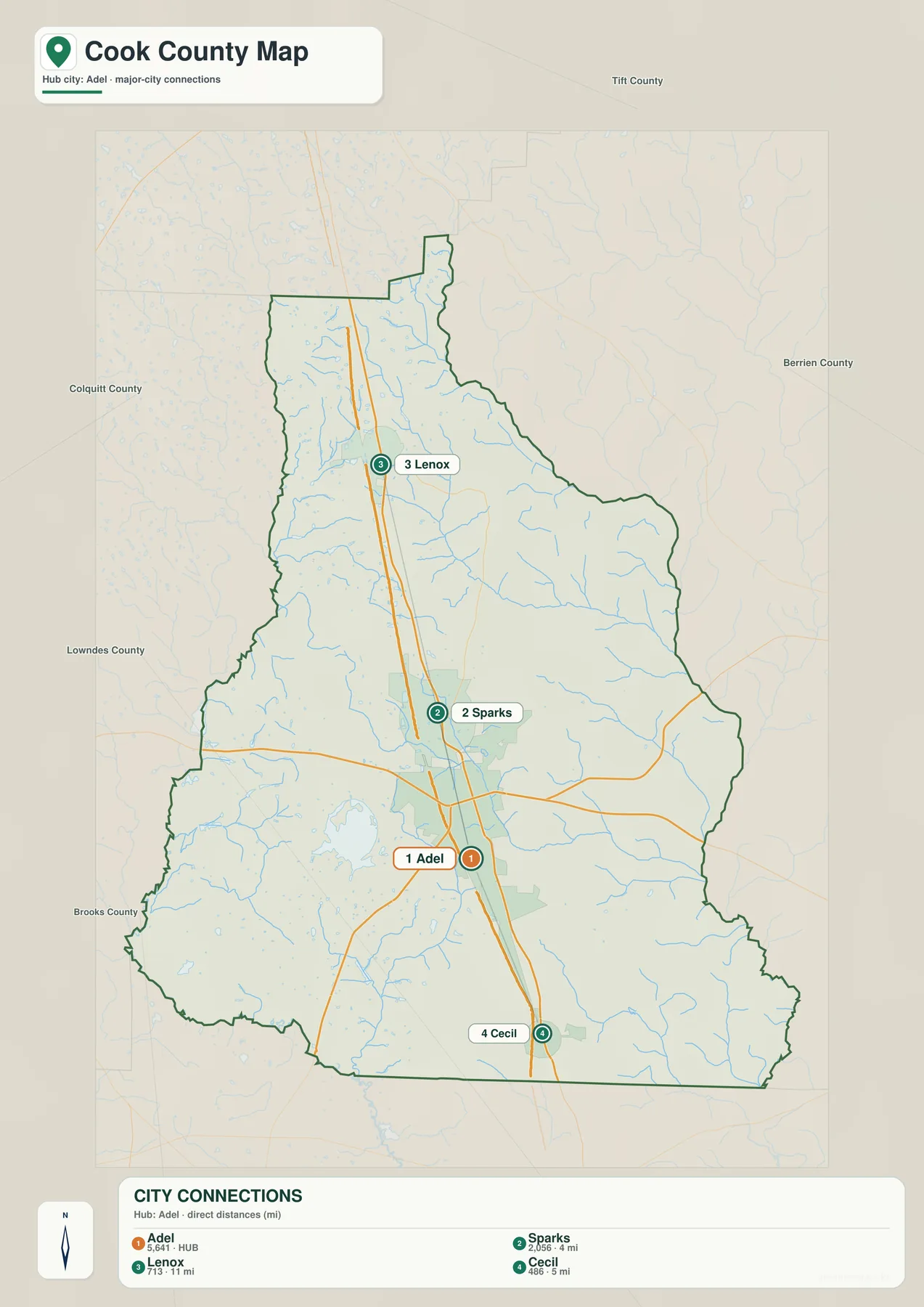
From north to south, the order is Lenox, Sparks, Adel, and Cecil. That simple sequence is one of the most useful facts to take from the map because it works well for classroom geography, county orientation, and trip planning at a broad scale. The map also labels neighboring Tift, Berrien, Colquitt, Lowndes, and Brooks counties, helping place Cook County within the larger south Georgia region.
Adel is more than the largest of the four city labels. As the county seat, it contains the county courthouse and other public services, and the map also shows the Wiregrass Georgia Technical College Cook Campus between Adel and Sparks. Those locations help explain why the central interstate corridor carries a mix of local government, education, retail, lodging, food service, and regional travel functions rather than serving only through traffic.
The package’s verified planning material covers Cook County together with Adel, Cecil, Lenox, and Sparks. Looking at the four municipalities as one county system is useful because transportation, economic development, housing, utilities, and public facilities cross city limits. The map shows where the towns sit, but the planning record provides the institutional context for why a small county often has to coordinate services across municipal boundaries.
Little River, Brushy Creek, New River, and the county’s smaller waters
The water map changes the visual emphasis completely. The Little River runs along part of Cook County’s western side and forms a natural boundary near Colquitt and Brooks counties. Existing USGS material in the package records a 577-square-mile drainage area at the Little River station near Adel. That is larger than Cook County itself, which means river conditions can respond to rainfall well upstream of the county line.
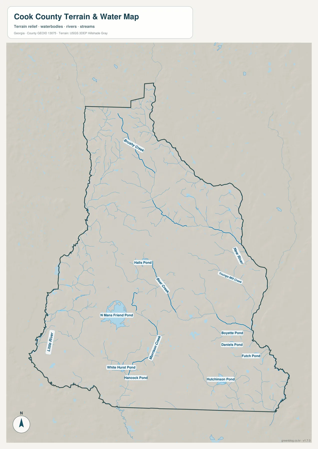
Several named streams stand out away from the western boundary. Brushy Creek crosses the northern part of the county, New River is prominent on the east, and Youngs Mill Creek joins the eastern drainage network. Bear Creek and Morrison Creek are labeled farther south and through the central-southern area. The map also identifies Halls Pond, North Mans Friend Pond, White Hurst Pond, Hancock Pond, Boyette Pond, Daniels Pond, Futch Pond, and Hutchinson Pond. Those smaller waters are easy to miss on a road-focused map but are an important part of the county’s rural landscape.
The earlier verified article explains the broader drainage divide in simple terms: much of the area west of I-75 drains toward the Little River, while the eastern side belongs to the Withlacoochee River watershed. The Little River later joins the Withlacoochee, which continues toward the Suwannee River and the Gulf of Mexico. The county’s relief is gentle, so the divide is not marked by a dramatic mountain ridge; it is expressed through subtle changes in slope and the direction of small tributaries.
Reed Bingham State Park adds a useful real-world example along the western side. The park straddles Cook and Colquitt counties beside the Little River. The source material in the package describes a 375-acre lake and roughly three river miles within the park, as well as bottomlands that can be periodically flooded. The water map is useful for geographic context, but it is not a flood map, parcel survey, boating chart, or real-time river-condition product. FEMA, county GIS, Georgia DNR, and USGS should be used when those specific questions matter.
A gentle elevation range with higher ground in the north
Cook County does not have mountains or deep canyons, yet the elevation map shows that the terrain is not perfectly flat. Higher brown and orange colors are most extensive in the north and northwest. Lower green ground becomes more common along the western Little River side, the southern boundary, and the creek valleys that cut through the county. The central area around Adel and Sparks lies between those extremes.
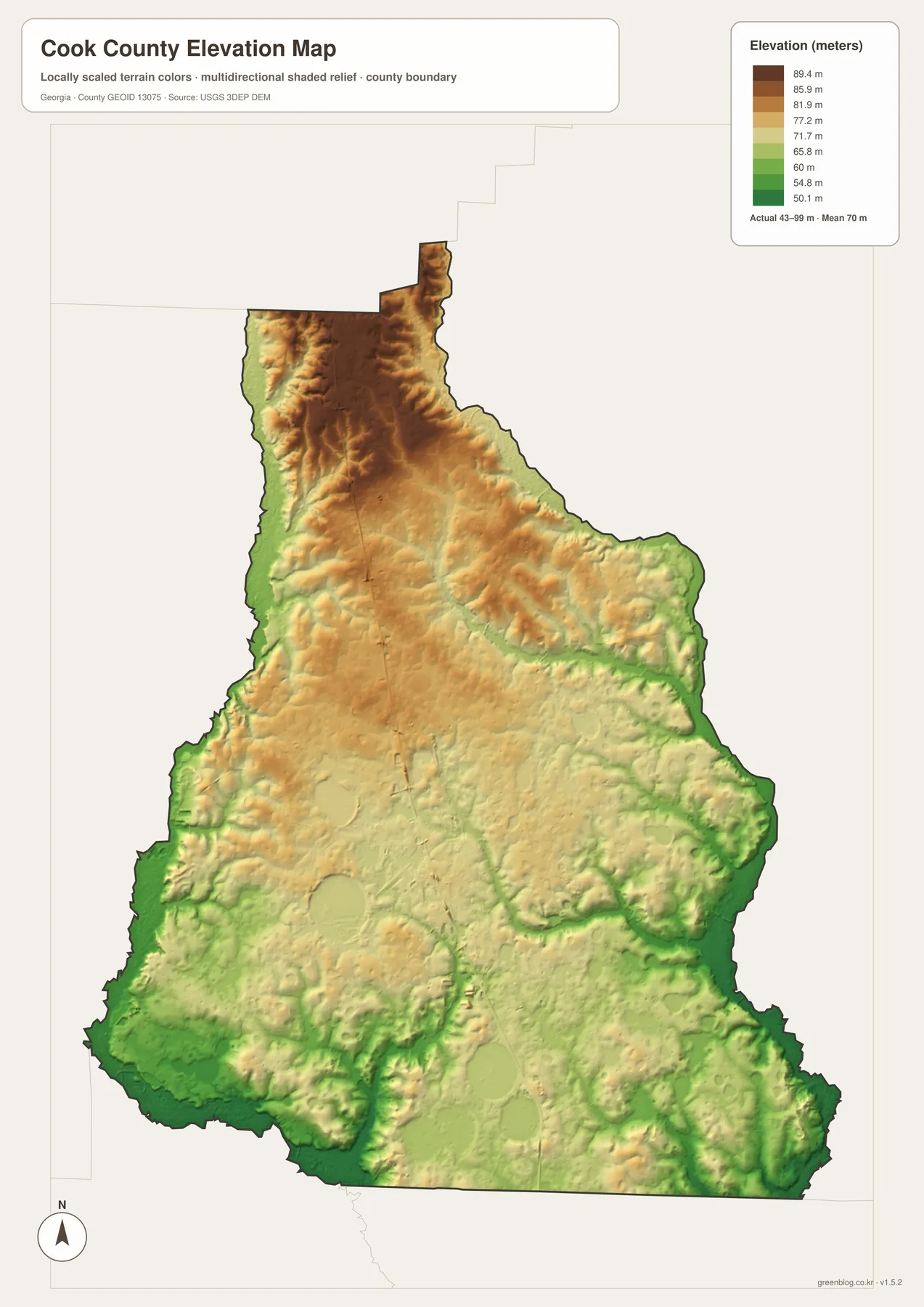
The supplied elevation legend reports an actual range of about 43 to 99 meters, with a mean near 70 meters. Those values are useful for countywide comparison, not as survey-grade elevations for a specific property. If a project requires exact ground height for construction, drainage, engineering, or property work, use the source USGS 3D Elevation Program data or a professional survey rather than reading a single color from this generalized map.
Putting the water and elevation maps side by side makes the relationship between terrain and drainage clearer. The lowest green corridors commonly follow the Little River and smaller streams, while the northern half contains more separated ridges and shallow valleys. The differences are modest by mountain-region standards, but they are enough to organize local drainage and to explain why streams branch through areas that otherwise appear nearly level.
Adel and Sparks sit in the broad middle part of the relief surface. Cecil lies closer to lower southern drainage ground, while the Lenox side reaches toward the higher north. This does not mean every point in those towns has the same elevation, and the map cannot predict flood risk or road grade. It is best used to see the general pattern before consulting more detailed elevation or hazard data.
Agriculture, county history, and the landscape beyond the interstate
Cook County’s rural landscape is closely tied to agriculture. The 2022 Census of Agriculture counted 210 farms and 77,736 acres of farmland, with $129.878 million in products sold. Crop sales represented 49 percent of the total and livestock, poultry, and related products 51 percent. Cotton covered 17,457 acres and peanuts 11,140 acres in the source material, showing why open fields are such an important part of the county landscape while also making clear that farming is not limited to one crop.
Highway-oriented services and other industries broaden the economy around that agricultural base. Adel and the I-75 exits support lodging, food service, retail, manufacturing, and distribution. Census material in the package gives an average commute of 25.6 minutes for workers in 2020–2024. That figure does not identify individual destinations, but it supports the idea that the county’s daily labor market extends beyond its small municipal centers toward larger south Georgia employment areas.
Cook County was created from Berrien County in 1918 as Georgia’s 155th county and named for Philip Cook, a soldier, attorney, and member of Congress. The 1939 courthouse in Adel remains an important landmark of county government. These facts add historical depth to the road map: the current interstate is a modern layer on a settlement pattern shaped earlier by railroads, farming, and small-town government.
Frequently Asked Questions
What is the order of the four mapped municipalities?
From north to south, the sequence is Lenox, Sparks, Adel, and Cecil. Actual driving routes depend on the local road network, so the downloadable county image should be paired with current navigation data.
Which county contains Reed Bingham State Park?
The park spans Cook and Colquitt counties along the Little River. Its lake, river corridor, and trails are best understood in relation to that shared western boundary.
Can the JPG determine parcel lines or flood risk?
No. The download is a general county-and-place reference, not a legal survey or Flood Insurance Rate Map. Use county GIS and recorded documents for parcels, and current FEMA and local water resources for flood analysis.
What is the north-to-south order of Cook County’s four incorporated towns?
From north to south, the order is Lenox, Sparks, Adel, and Cecil. Interstate 75 and U.S. 41 follow the same broad corridor, which makes the sequence easy to recognize on the county and city maps.
Is Reed Bingham State Park entirely inside Cook County?
No. The verified source material places the park across Cook and Colquitt counties along the Little River. Its lake and river setting make the western county boundary especially useful to view on the water map.
Can I use the 43–99 meter elevation range as an exact property elevation?
No. The range describes the generalized countywide map surface. Survey, engineering, construction, or drainage work should use detailed USGS elevation data or a professional site survey.
What files are included in the Cook County download ZIP?
The ZIP contains four original high-resolution A3 JPG files: county, city, water, and elevation maps. The WebP images embedded in the article are smaller previews for fast viewing.
Map File Information
Cook County Map Files
- Included Files: 4 high-resolution A3 JPG maps: county, city, water, and elevation
- File Type: JPG files in a ZIP archive
- Intended Use: Printing, education, presentations, and map-based projects
Related Maps
- A Clinch County Map
- A Columbia County Georgia Map
- Athens and the Oconee Rivers on the Clarke County Georgia Map
Sources and References
Population, land area, agriculture, and local history follow the verified material preserved in the package. Water and terrain descriptions use the supplied map previews together with official source links. Check the responsible agency for the newest statistics or legal boundaries.
- U.S. Census Bureau QuickFacts: Cook County, Georgia
- New Georgia Encyclopedia: Cook County profile and history
- Georgia Department of Community Affairs: Cook County and cities comprehensive plan
- USDA 2022 Census of Agriculture Cook County profile
- Georgia DNR: Reed Bingham paddling information
- U.S. Geological Survey: Little River station inventory
Green Map creates custom-edited map images using open geographic data sources such as geoBoundaries, Natural Earth, OpenStreetMap, and government open data. These maps are edited visual materials, not raw data files, and are provided for education, documents, presentations, and graphic reference.