Washington County occupies the heart of northwest Arkansas, where Fayetteville and Springdale form the largest urban concentration and the landscape rises sharply into the Boston Mountains toward the south. Prairie Grove and Lincoln sit to the west, Elkins is to the east, and West Fork and Winslow mark the transition into rougher mountain terrain. The county is not a single flat urban area: developed northern corridors, river valleys, and high southern ridges all appear within the same boundary.
Download the original high-resolution A3 JPG files from this Washington County Arkansas Map set in one ZIP near the end of the page. The package includes the county reference map, ranked city view, terrain-and-water map, and elevation map. Start with Fayetteville and Springdale for the road and settlement pattern, then use the water and elevation views to follow the White River headwaters, the Illinois River, and the high Boston Mountain country south of the urban area.
Table of Contents
Fayetteville and Springdale form the county’s strongest urban corridor
Fayetteville is the county seat, and Washington County’s courthouse and major administrative offices are located there. On the reference map, Fayetteville appears near the north-central part of the county with a dense network of roads and developed areas. Springdale continues the urban pattern immediately to the north, while Johnson, Tontitown, and Elm Springs occupy nearby parts of the same broad corridor.
West of Fayetteville, Farmington leads toward Prairie Grove, and Lincoln lies farther southwest. Goshen and Elkins provide eastern reference points. South of Fayetteville, Greenland, West Fork, and Winslow follow a much narrower development pattern through increasingly rugged terrain. This change in settlement density is one of the clearest differences between the northern half of Washington County and the Boston Mountain area to the south.
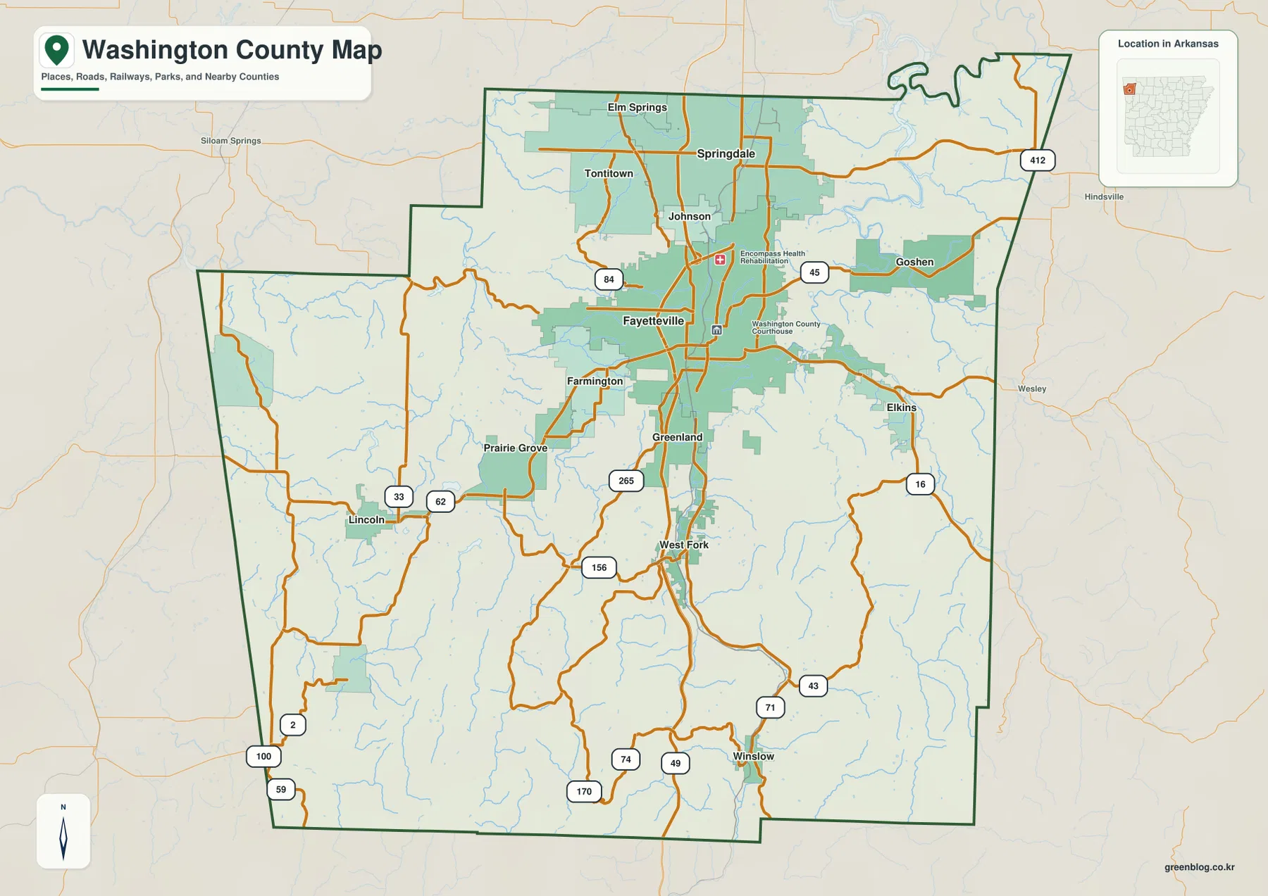
U.S. Highway 71 is a useful north–south guide. The Encyclopedia of Arkansas describes the highway descending through the Boston Mountains into Winslow, then continuing through West Fork and Greenland toward Fayetteville. The supplied map shows the same sequence clearly. Comparing that route with the elevation image explains why the southern road corridor is narrower and more winding than the street network around Fayetteville and Springdale.
The ranked city view makes the northern concentration easy to see
The city map highlights six major places and removes much of the detail found on the county reference map. Fayetteville is listed first, Springdale second, and Farmington third. Prairie Grove, Tontitown, and Elkins complete the ranked set. Four of those places are close to the Fayetteville–Springdale area, while Prairie Grove and Elkins sit farther west and east.
The population values printed on the supplied graphic are best treated as comparison figures within the image rather than as current Census estimates. The map’s main strength is positional. It shows the size and location of the principal communities without requiring the reader to sort through every road, facility, and small place label on the general map.
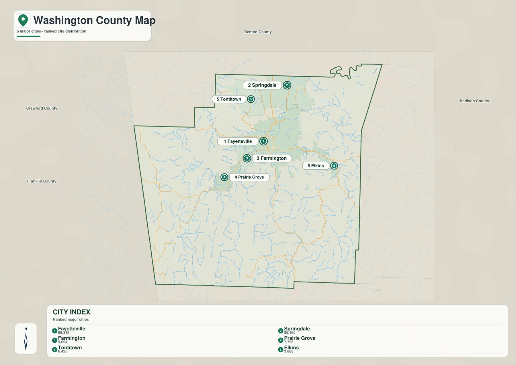
The simplified city view is not a complete list of communities. The county reference map also includes Greenland, West Fork, Winslow, Lincoln, Johnson, Goshen, and other smaller places. Use the ranked graphic when you want a quick picture of the largest centers, and return to the county map when local roads and smaller communities matter.
White River headwaters cut through the eastern and central valleys
The White River is one of the most important waterways shown in Washington County. The Encyclopedia of Arkansas notes that the river begins in the Boston Mountains of northwestern Arkansas, flows toward the Fayetteville area, and then turns north. On the terrain-and-water map, the White River follows the eastern and northeastern side of the county while a network of forks and smaller streams drains the higher interior.
The West Fork White River is prominent through the central and southern portion of the map, bending north from the mountain country. The Middle Fork White River occupies a separate valley farther east. These streams do not cross the high ridges directly; they follow lower corridors between them. The terrain shading makes that relationship particularly easy to see in the southern half of the county.
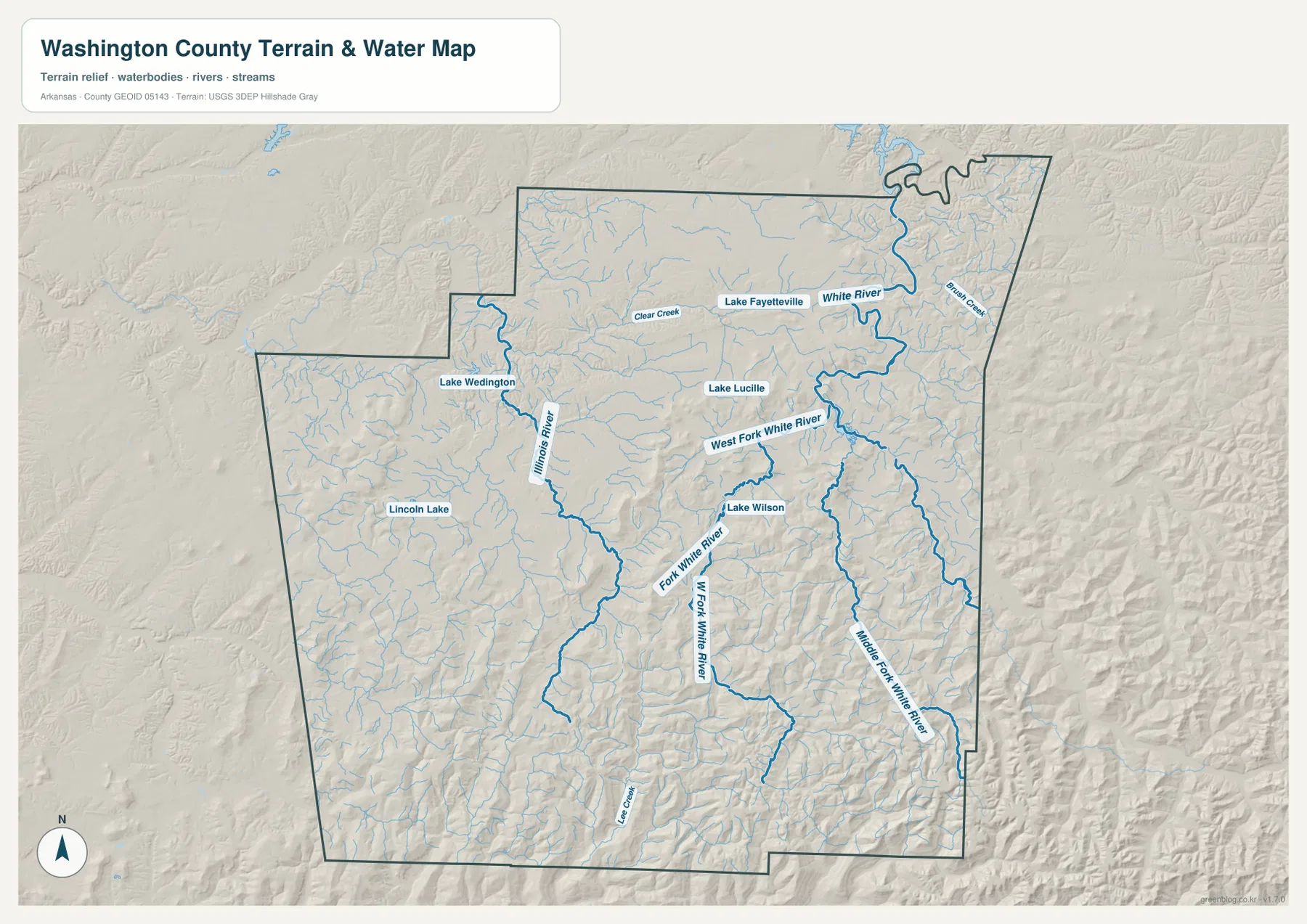
The western side has a different drainage reference: the Illinois River runs through the western interior. Lake Wedington and Lincoln Lake are also visible in that half of the county. Near the northern urban area, Lake Fayetteville and Lake Lucille provide recognizable water landmarks, while Lake Wilson appears closer to the central mountain transition. Together, these features show that Washington County drains in more than one direction.
This map is intended for county-scale water and terrain reference. It does not replace flood-hazard mapping, parcel surveys, water-quality reports, or navigation information. When a decision involves legal boundaries, current hazards, or safe water access, use current specialized information from the responsible agency.
The Boston Mountains rise sharply across the southern part of the county
The elevation map shows an actual Washington County range of about 279 to 726 meters, with a mean near 428 meters. The highest tan and brown terrain covers much of the south and southeast, where closely spaced ridges and valleys form the Boston Mountain landscape. North toward Fayetteville and Springdale, the colors become greener and the land generally opens into broader, lower surfaces.
Winslow is one of the clearest examples of a community set within this rugged southern terrain. Highway 71 passes through the mountain corridor before reaching West Fork, Greenland, and Fayetteville. The Encyclopedia of Arkansas describes the Boston Mountains as rugged highland terrain where transportation historically followed narrow, winding routes. That description fits the strong relief visible on the supplied elevation map.
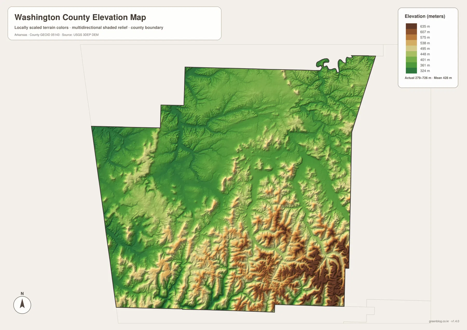
The western Prairie Grove and Lincoln area is lower than the strongest southeastern ridges but still contains rolling terrain and numerous creek valleys. The Illinois River occupies lower ground through that part of the county. Moving southeast, ridges become taller and more closely packed. The difference between the open northern development corridor and the rugged southern mountains becomes much clearer when the county and elevation maps are viewed together.
The elevation colors are designed for broad terrain comparison, not property-level measurement. They are useful for seeing where Washington County is higher or lower, but they should not be used for construction, drainage design, exact slope calculations, or parcel elevations. Detailed USGS 3D Elevation Program data or professional measurements are appropriate when precision is required.
Use Fayetteville to divide the urban north from the mountain south
A practical way to read the county is to locate Fayetteville first, then identify Springdale immediately to the north. Johnson, Tontitown, and Elm Springs help show how the northern development spreads beyond those two cities. From Fayetteville, move west to Farmington and Prairie Grove to understand the broader western valley-and-prairie side of the county.
Next, move south through Greenland, West Fork, and Winslow. The road map becomes less dense while the elevation map shows progressively stronger relief. The West Fork White River and its tributaries occupy lower valleys through this mountain terrain. Looking at the road, water, and elevation views in the same sequence makes the transition far easier to understand than memorizing road numbers alone.
For the east, Goshen and Elkins are useful place markers, while the White River system provides the main water reference. On the west, Prairie Grove and Lincoln can be paired with the Illinois River and Lake Wedington. Building the map around a few recognizable towns and waterways makes the large county much easier to navigate visually.
Choose the map according to the information you need
The county reference map is the best starting point for towns, roads, nearby counties, waterways, and the boundary. The ranked city map is cleaner when you only need to compare the principal population centers. The terrain-and-water image is better for the White River forks, Illinois River, and lake locations, while the elevation map provides the clearest picture of the Boston Mountains and the lower northern urban corridor.
Two maps together can be especially useful for a lesson or regional presentation. Pair the county and city views to show how Fayetteville and Springdale dominate the northern settlement pattern. Pair the county and elevation views for Winslow and West Fork to explain how Highway 71 passes through the mountain terrain. Pair the water and elevation maps when discussing the White River headwaters and the valleys between high southern ridges.
Each downloadable JPG measures 3638 × 2572 pixels and is suitable for A3 landscape printing, zooming into labels, or placing a map in a report or classroom handout. Keep the original aspect ratio when resizing so roads, streams, and the county outline are not stretched. Printer margins vary, so a test print is useful before producing multiple copies.
Frequently Asked Questions
What is the county seat of Washington County, Arkansas?
Fayetteville is the county seat. The Washington County Courthouse and major county offices are located there, and the reference map shows Fayetteville as the largest developed area near the center of the northern urban corridor.
How is the White River connected to Washington County?
The White River begins in the Boston Mountains of northwestern Arkansas and flows toward the Fayetteville area before turning north. The supplied water map also shows the West Fork and Middle Fork, which occupy major valleys through the county.
Why is southern Washington County much higher on the elevation map?
The southern part of the county extends into the rugged Boston Mountains. The supplied elevation map shows an overall range of about 279 to 726 meters, with the strongest high-elevation colors concentrated in the south and southeast around deeply cut ridges and valleys.
Map File Information
The ZIP contains the original Washington County reference, city, terrain-and-water, and elevation maps as high-resolution JPG files.
- Included Files: County reference map, city map, terrain-and-water map, elevation map
- Printable Size: 3638 × 2572 pixels each
- File Type: Four high-resolution JPG files in one ZIP archive
Related Maps
Sources and References
- Washington County, Arkansas – Official Government Website – County government and administrative information based in Fayetteville.
- Encyclopedia of Arkansas – Washington County – County history and regional background for Fayetteville, Springdale, and the Boston Mountain area.
- Encyclopedia of Arkansas – White River – Background on the White River headwaters in the Boston Mountains and its course through the Fayetteville area.
- USGS National Hydrography – Official information about U.S. rivers, streams, lakes, and hydrographic data.
- USGS 3D Elevation Program – Official elevation and terrain data information.
Green Map creates custom-edited map images using open geographic data sources such as geoBoundaries, Natural Earth, OpenStreetMap, and government open data.
These maps are edited visual materials, not raw data files, and are provided for education, documents, presentations, and graphic reference.