Saline County sits southwest of Little Rock, but its map changes character quickly as you move away from the eastern cities. Benton and Bryant form the most obvious urban corridor, with Interstate 30 carrying traffic toward the Little Rock side of the county. Farther west and northwest, city labels thin out and the ground rises into long Ouachita ridges cut by narrow valleys. Between those two settings, several upper branches of the Saline River descend toward lower central and southern ground.
This page brings those features together with a general county map, a city map, a terrain-and-water map, and an elevation map. You can use the WebP images for a quick look on screen, then download the four full-resolution A3 JPG originals in one ZIP from the file box below. The originals are better suited to printing, classroom handouts, reports, and large presentation slides because each image is 3638 × 2572 pixels.
The Encyclopedia of Arkansas describes Saline County as an 1835 county that spans noticeably different terrain, from mountainous country in the northwest to lower land toward the southeast. Its Saline River entry also connects the river to the Ouachita Mountains and the several forks that come together in this county. Those broad descriptions match the supplied maps well: the highest ridges occupy the northwest, while the river branches move toward lower central valleys before the main river leaves the county to the south.
Table of Contents
Benton and Bryant anchor the eastern side of the county
Benton is the easiest place to use as an orientation point. The Saline County Courthouse is marked there, and Bryant lies immediately to the east along the same developed belt. Alexander and Shannon Hills sit closer to the Pulaski County line, while Bauxite is southeast of Benton and Haskell is to the southwest. The pattern is not evenly spread across the county. Most of the clearly labeled communities occupy the eastern half, while the long northwestern extension contains far fewer urban labels.
The road network reinforces that contrast. Interstate 30 approaches from the southwest near Haskell, passes Benton and Bryant, and continues toward Little Rock. Arkansas 5 reaches west from the Benton area, while routes 9 and 298 extend into hillier central and northern sections. Routes 35 and 67 serve the southern side, and the 530 corridor appears near the eastern edge. Around Benton the routes converge and branch in several directions; in the higher northwest, the network is visibly more widely spaced.
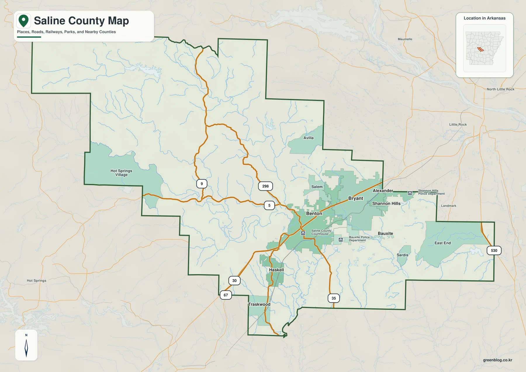
The county boundary adds another useful clue. Saline County stretches a long way toward Garland and Perry counties in the northwest, while its eastern side presses toward Pulaski County and the Little Rock metropolitan area. Hot Spring County lies to the southwest and Grant County continues along the southern side. Seen in that wider setting, Saline County occupies a transition zone between the more urban Little Rock-facing corridor and the rougher Ouachita country toward Hot Springs and the northwest.
The city index makes the eastern cluster easy to compare
The city map strips away much of the road detail and ranks six major cities. Benton is listed at 36,595 and Bryant at 21,504, making them the two largest places on this particular map. Shannon Hills and Haskell are each a little above 4,000, followed by Alexander at 3,587 and Bauxite at 846. These are values printed on the supplied city image, not a substitute for the latest Census estimate, but they make the relative size of the mapped centers immediately clear.
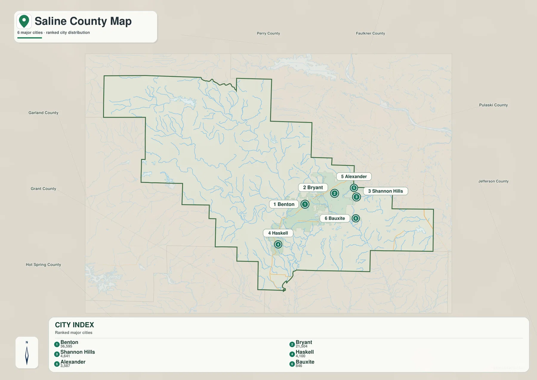
The placement of those six points is as useful as the numbers. Benton and Bryant sit close together, Alexander and Shannon Hills lie farther east toward Pulaski County, and Haskell and Bauxite sit on opposite sides of Benton to the southwest and southeast. There is no comparable group of ranked cities in the long northwestern upland. That makes the city map a simple way to see how strongly the county’s main population centers favor the I-30 side rather than the mountain interior.
Four Saline River headwaters descend from the uplands
The terrain-and-water map shifts attention away from roads and toward the drainage network. North Fork Saline River occupies the northern side, while Alum Fork and Middle Fork descend through the western half and South Fork runs farther south. These named branches do not remain separate all the way across the county. They approach one another on lower central and southern ground and feed the main Saline River before it continues beyond the county line.
Several lakes and creeks help with orientation. Lake Winona sits in the high northwest, and Lake Norrell lies farther east near the northern drainage. Hurricane Creek crosses the eastern side toward the southeast, with Hurricane Lake and Ferguson Lake shown nearby. Lake Maumelle is visible outside the northern boundary and provides a useful regional landmark, but the most important internal water story is the way several upland forks descend and combine into the Saline River system.
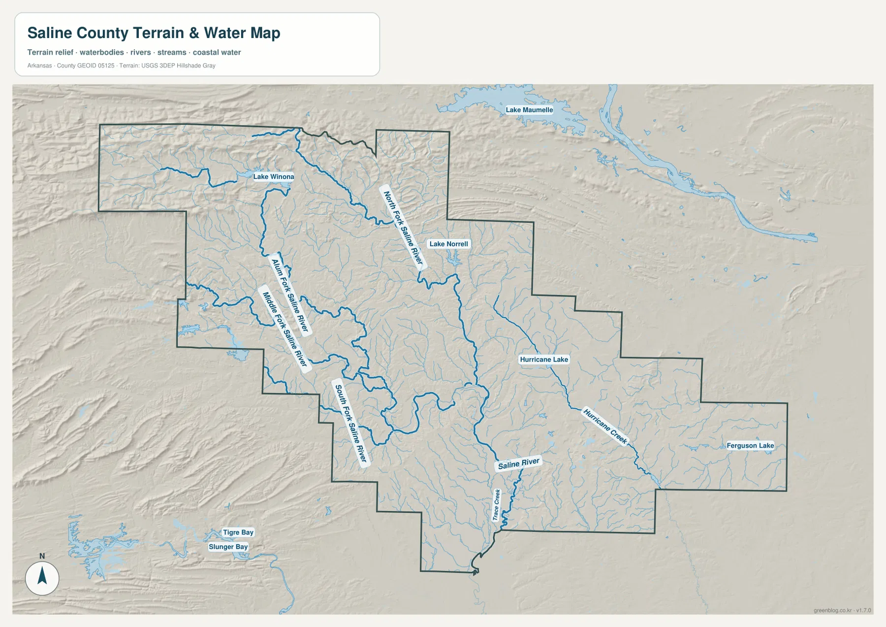
The shaded relief behind the blue water lines explains why the rivers follow these routes. Headwaters occupy narrow valleys between higher ridges, then the channels widen and converge as the terrain becomes lower. This map is intended for geographic reference, not for flood-zone decisions, navigation, water-quality judgments, or property work. Those tasks require current specialized data from the responsible agency.
Elevation climbs sharply toward the northwest
The elevation map shows the county’s physical contrast more directly than any of the other views. Its legend reports an actual range of about 69 to 544 meters and a mean near 160 meters. Most of the east, center, and south is green, indicating lower ground, while the far northwest changes to yellow, orange, and brown. Long ridges and deeply cut valleys are especially clear in that upper-left portion of the county.
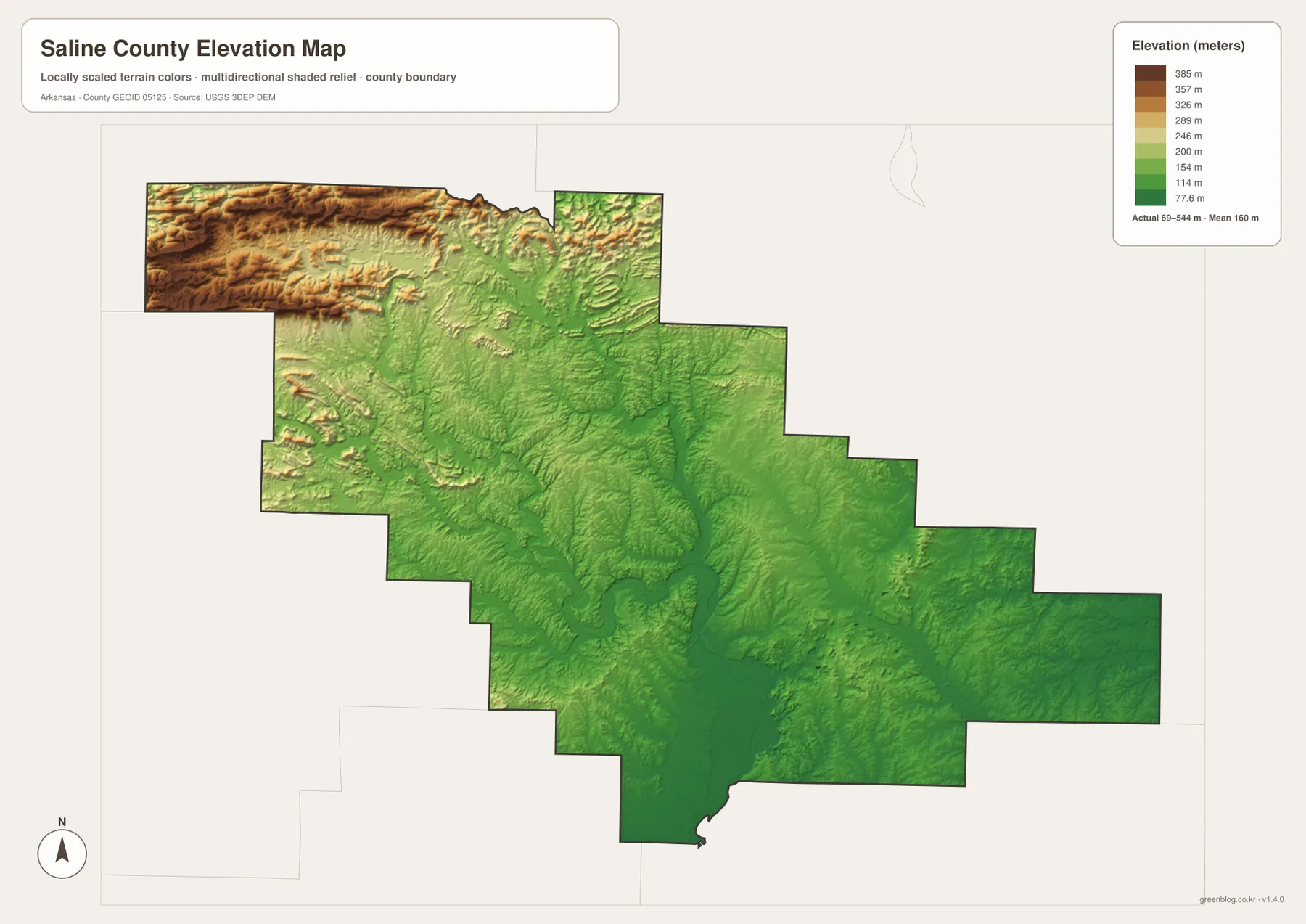
The change in relief also helps explain the water map. Lake Winona and several upper river branches lie among the higher ridges, whereas the central Saline River corridor cuts through greener, lower terrain. Moving southeast toward the Benton–Bryant side, the surface is generally lower and less rugged than the northwest extension. The county is therefore not simply a flat suburban area or a mountain county; both landscapes are present within the same boundary.
Use the elevation colors for broad comparison only. They are useful for showing where the highest and lowest parts of the county are located, but they do not provide survey-grade heights for a parcel, a road profile, construction work, or drainage design. Exact work should rely on detailed USGS 3DEP products and professional field surveying when appropriate.
Benton is a practical starting point for reading the whole county
If you are unfamiliar with Saline County, start at Benton and move outward. Bryant is east along the I-30 corridor, Haskell is southwest, and Bauxite is southeast. Continuing west brings fewer city labels and more broken terrain, while the long northwestern arm reaches the highest ridges on the elevation map. Looking south from the same reference point, the Saline River forks draw together and the main river exits the county.
This approach also keeps the county from being reduced to its relationship with Little Rock. The eastern communities are clearly tied to the metropolitan side, but a large portion of Saline County is made up of hills, ridges, lakes, and headwater valleys. The general map is strongest for roads and settlement, while the water and elevation views reveal the much less urban landscape to the west and northwest.
Choose the map based on the detail you need
For a road-and-location overview, use the general county map to find Benton, Bryant, nearby communities, highways, and the county outline. The city map is cleaner when the task is to compare the six ranked places without the extra road labels. The terrain-and-water map is the better choice for the Saline River forks, Lake Winona, Lake Norrell, and Hurricane Creek, while the elevation map makes the northwest highlands and lower central valleys easiest to explain.
When printing or placing a map in a large document, use the downloadable originals rather than enlarging the on-page WebP previews. Each JPG is 3638 × 2572 pixels and prepared at A3 proportions. A road or city presentation may use the general and city views together, while a lesson about headwaters and terrain can pair the water and elevation images without forcing every label onto one page.
Frequently Asked Questions
Where is the county seat of Saline County?
Benton is the county seat. On the general map it lies in the east-central developed area near Interstate 30, with Bryant immediately to the east, Haskell to the southwest, and Bauxite to the southeast. The Saline County Courthouse is also marked in Benton.
How do the Saline River forks fit together inside the county?
North Fork, Alum Fork, Middle Fork, and South Fork descend from higher northern and western terrain. They move toward lower central and southern valleys, where the channels draw together and feed the main Saline River. Viewing the water and elevation maps side by side makes that downhill relationship especially clear.
Can the 69–544 meter elevation range be used for property surveying?
No. The range is useful for countywide comparison, such as distinguishing the high northwestern ridges from the lower central and southeastern valleys. It is not precise enough for parcel elevations, construction, road engineering, or drainage design. Use detailed USGS elevation data and professional surveying for exact measurements.
Map File Information
The ZIP contains the original JPG versions of the Saline County general, city, terrain-and-water, and elevation maps.
- Included Files: County, city, terrain-and-water, and elevation maps
Related Maps
Sources and References
- Encyclopedia of Arkansas – Saline County – Background on the county’s creation, Benton, and the contrast between the mountainous northwest and lower southeastern terrain.
- Encyclopedia of Arkansas – Saline River – Reference information on the Ouachita headwaters and the forks that converge in Saline County.
- U.S. Census Bureau TIGER/Line Shapefiles – Official geographic reference for county boundaries and transportation features.
- USGS National Hydrography – Official hydrography reference for rivers, streams, and water features.
- USGS 3D Elevation Program – Source information for detailed U.S. elevation data and 3DEP products.
Green Map creates custom-edited map images using open geographic data sources such as geoBoundaries, Natural Earth, OpenStreetMap, and government open data.
These maps are edited visual materials, not raw data files, and are provided for education, documents, presentations, and graphic reference.