Scott County, Arkansas is a mountain county built around long Ouachita ridges and the valleys between them. Waldron sits near the center of the county and is the easiest reference point on the maps because U.S. 71 and several state highways meet there. Mansfield appears near the northern county line, while Boles and Blue Ball sit farther from the main center. If you need the original files rather than the browser previews, the four high-resolution A3 JPG maps on this page can be downloaded together in a ZIP from the map file box below.
The road pattern, river network, and elevation all tell the same story in different ways. Roads spread outward from Waldron through lower corridors, the Poteau River system follows broad valleys, and long ridges separate those valleys from the Petit Jean and Fourche La Fave drainage areas. The supplied maps therefore work best as a group: one shows county boundaries and roads, another simplifies the major city pattern, a third combines terrain and water, and the elevation view makes the repeated high and low bands easy to compare.
The Encyclopedia of Arkansas describes Scott County as part of the Ouachita Mountain region in west-central Arkansas and identifies Waldron as the county seat. It also notes that a portion of Mansfield lies within the county. Those facts are easy to connect to the maps. Waldron occupies a broad central valley, Mansfield is tucked against the northern edge, and much of the rest of the county is dominated by forested ridges, narrow stream courses, and widely spaced roads.
Table of Contents
Use Waldron to orient the road network and county boundary
Begin with the county reference map and find Waldron near the middle. The Scott County Courthouse is labeled there, and U.S. 71 passes north-south through the same area. Arkansas highways 80 and 248 extend across the central part of the county, while routes 250 and 343 lead toward the southern and southeastern interior. Because several roads meet in one place, Waldron works as a practical anchor when you switch to the water and elevation maps later.
Mansfield lies close to the northern boundary, where U.S. 71 and state routes 23 and 378 connect the county with Sebastian County. Logan County is to the northeast and Yell County is along the eastern side. Polk and Montgomery counties border the mountainous country to the west and southwest. The outline is not a simple rectangle; it steps around several corners, especially in the north and south, so keeping the county boundary visible helps when a road or stream continues beyond Scott County.
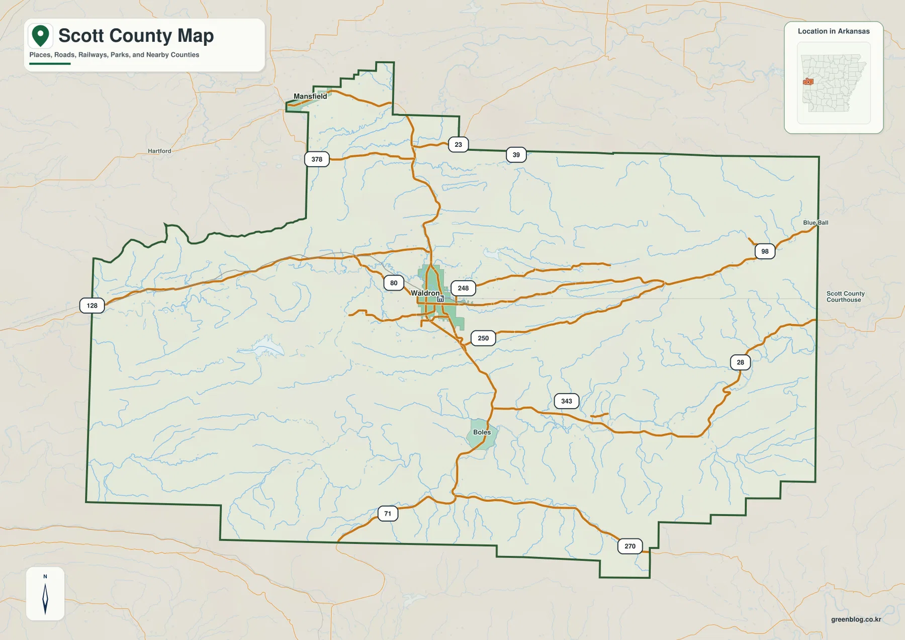
This map is the best starting point when you need local context rather than only physical geography. Boles appears south of Waldron, and Blue Ball is shown toward the eastern edge, giving you extra place references beyond the two largest city markers. It is also useful for seeing which road leaves Waldron in a particular direction. The map does not show current traffic, closures, or travel times, so it should be paired with current navigation information for an actual trip.
Waldron and Mansfield sit in very different parts of the county
The city map strips away most of the road labels and emphasizes the two major city markers included in this package. Waldron is ranked first and sits in the central valley, while Mansfield is ranked second near the northern edge. The large gap between them is important. Scott County does not have a dense chain of major towns stretching across the whole county; the main settlements are separated by broad areas of mountain and valley terrain.
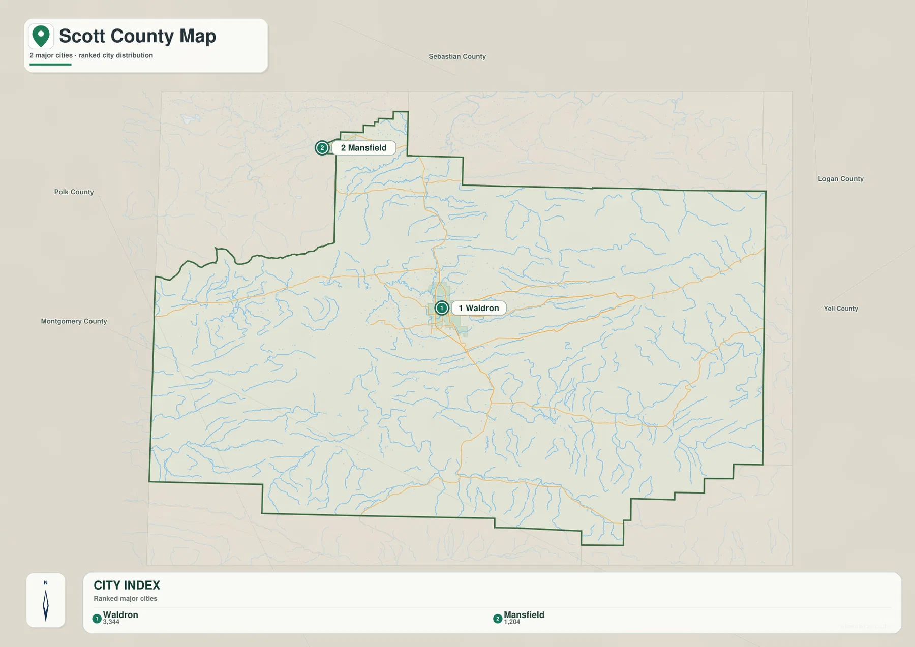
The rank values shown on the map are best treated as a snapshot for comparison, not as a substitute for current Census estimates. If you need updated population figures, check the U.S. Census Bureau. For map reading, the important information is location: Waldron stands out as the principal central settlement, while Mansfield occupies a separate position at the county’s northern edge. That simple pattern can be easier to explain on a classroom slide than the more detailed road map.
When smaller communities matter, return to the county reference map. It adds Boles, Blue Ball, and the roads that link those places to Waldron and the county boundary. Using the two maps together lets you choose how much detail to show. The city map keeps attention on the main population centers; the reference map is better for local roads, county edges, and a broader set of place names.
The Poteau system occupies one set of valleys while other rivers follow separate corridors
The terrain-and-water map reveals how strongly the stream network is controlled by the mountain relief. The Poteau River crosses the central and western part of the county, while the East Fork Poteau River approaches through a separate valley from the east. Farther north, the Petit Jean River follows another low corridor. In the southern half, the Fourche La Fave River winds through a different valley system. These rivers are not simply spread across one broad plain; ridges separate them into distinct drainage corridors.
Smaller features add useful detail. Lake Waldron is labeled northwest of the county seat, and Lake Hinkle lies farther west. The Black Fork Poteau River occupies the southwestern side, while Jones Creek, Dutch Creek, Ross Creek, and Mill Creek show how smaller streams descend from the ridges toward larger valleys. Following those tributaries helps explain why the landscape is cut into many narrow drainage lines even where only a few towns or major roads are labeled.
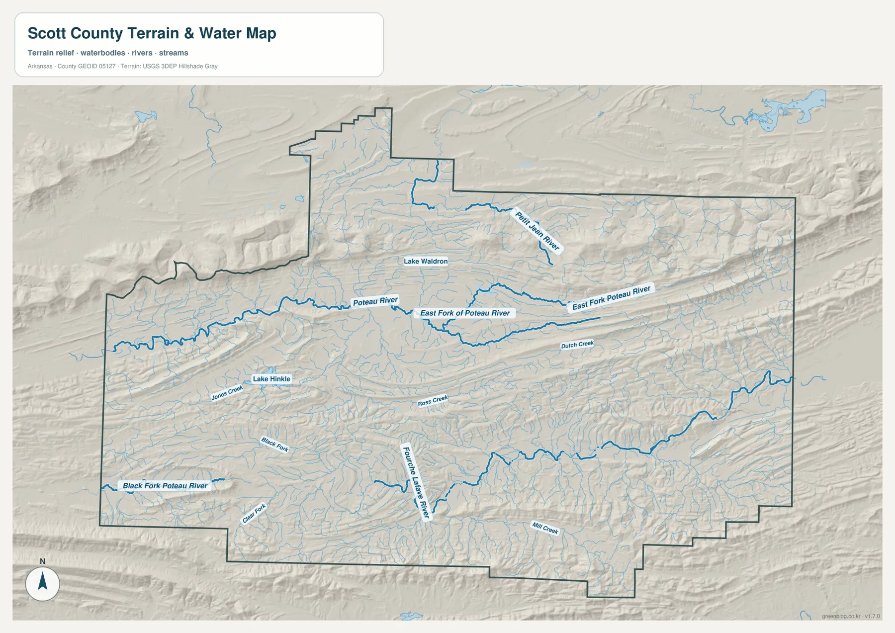
Waldron makes more sense when this map is compared with the road map. The town occupies relatively open, lower ground within a broad valley rather than a ridge crest. Several roads can therefore approach the same central area without crossing the highest terrain. This map is intended for general river and terrain reference. It should not be used as a flood-hazard map, water-quality assessment, property boundary source, or navigation chart.
Repeated Ouachita ridges create long bands of high and low ground
Scott County’s elevation pattern is distinctive because there is no single smooth slope from one side of the county to the other. Long ridges repeat across the map, often in roughly east-west bands, with lower valleys running between them. Higher brown and tan terrain is prominent in the east and northeast and appears again along several southern ridges. Lower green areas form elongated corridors through the center and west, including the valley around Waldron and parts of the Poteau River drainage.
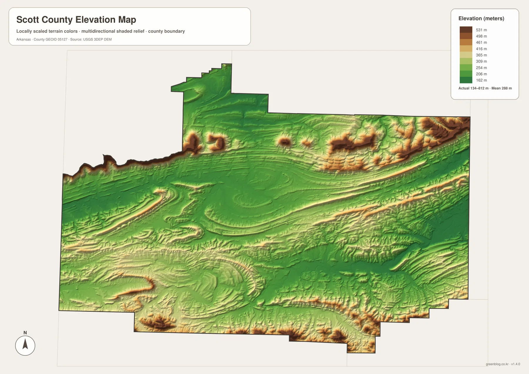
The map note gives an approximate county elevation range of 134 to 812 meters and a mean near 288 meters. Those numbers summarize county-scale relief. The locally scaled colors are designed to make higher ridges and lower valleys easy to compare, not to provide a surveyed elevation for a particular parcel or road grade. For engineering, construction, or property-level measurements, use detailed USGS 3DEP products and appropriate professional survey data.
Pairing the elevation map with the water map makes the relationship between landform and drainage easy to see. The Poteau and Fourche La Fave river corridors occupy lower bands, while the intervening ridges separate one valley system from another. That repeated ridge-and-valley form is more useful for understanding Scott County than a simple statement that the county is mountainous. It also explains why roads and settlements tend to favor the broader low corridors rather than the steepest parts of the county.
Choose the map that matches the question you need to answer
The county reference map is the strongest choice for roads, boundaries, and smaller named places. Use the city map when a clean comparison of Waldron and Mansfield is more important than local road detail. The terrain-and-water view is better for explaining rivers, lakes, tributaries, and the valleys between ridges. The elevation map works best when the goal is to show the contrast between long high ridges and the lower corridors occupied by roads and streams.
The WebP images on the page are browser-friendly previews. For printing, zooming, classroom materials, reports, or presentation slides, use the downloadable originals. Each JPG is 3638 by 2572 pixels in an A3 landscape proportion. The ZIP combines the county reference map, city map, terrain-and-water map, and elevation map so the full-resolution files can be saved together.
Frequently Asked Questions
What is the county seat of Scott County, Arkansas?
Waldron is the county seat. It appears near the middle of the county on the reference map, with the courthouse, U.S. 71, and several state highways clustered around the same central valley.
Do the Poteau River and Fourche La Fave River use the same valley?
No. The Poteau River system occupies central and western valleys, while the Fourche La Fave River follows a separate corridor farther south. The elevation map shows ridges between those drainage areas, making the separation easier to see.
Can the 134–812 meter elevation range be used for a property survey?
No. It is a county-scale summary that helps compare broad high and low areas. It does not provide a surveyed elevation for a specific parcel, road, or building site. Detailed USGS elevation products and a professional survey are appropriate when precise measurements are required.
Map File Information
Download the four original high-resolution A3 JPG maps for Scott County in one ZIP archive.
- Included Files: County reference, city, terrain-and-water, and elevation maps
- Printable Size: 3638 × 2572 pixels each
- File Type: Four JPG files in one ZIP archive
Related Maps
Sources and References
- Encyclopedia of Arkansas – Scott County – Background on county geography, Waldron, Mansfield, and the major river valleys.
- U.S. Census Bureau QuickFacts – Scott County, Arkansas – Official county population and demographic statistics.
- USDA Forest Service – Ouachita National Forest – Information about the Ouachita National Forest and the Waldron-area ranger district.
- USGS National Hydrography – Official U.S. hydrography information for rivers, streams, and waterbodies.
- USGS 3D Elevation Program – Official elevation data and 3DEP product information.
Green Map creates custom-edited map images using open geographic data sources such as geoBoundaries, Natural Earth, OpenStreetMap, and government open data.
These maps are edited visual materials, not raw data files, and are provided for education, documents, presentations, and graphic reference.