Searcy County sits in the Ozark country of north-central Arkansas, where small communities occupy narrow valleys and the Buffalo River bends through the northern part of the county. Marshall is the county seat and the clearest road hub on the map, while Leslie lies to the southeast and Gilbert, St. Joe, and Pindall form a looser chain toward the northwest. The county is mountainous enough that roads, streams, and settlements make more sense when they are viewed together rather than as separate features.
The downloadable set on this page includes four original high-resolution A3 JPG maps in one ZIP archive: a county reference map, a city-connections map, a terrain-and-water map, and an elevation map. The reference map is the quickest choice for roads and places, while the water and elevation views are better for understanding the Buffalo River valley, southern ridges, and the many smaller creeks that cut through the county.
Table of Contents
Marshall anchors a road network spread across mountain valleys
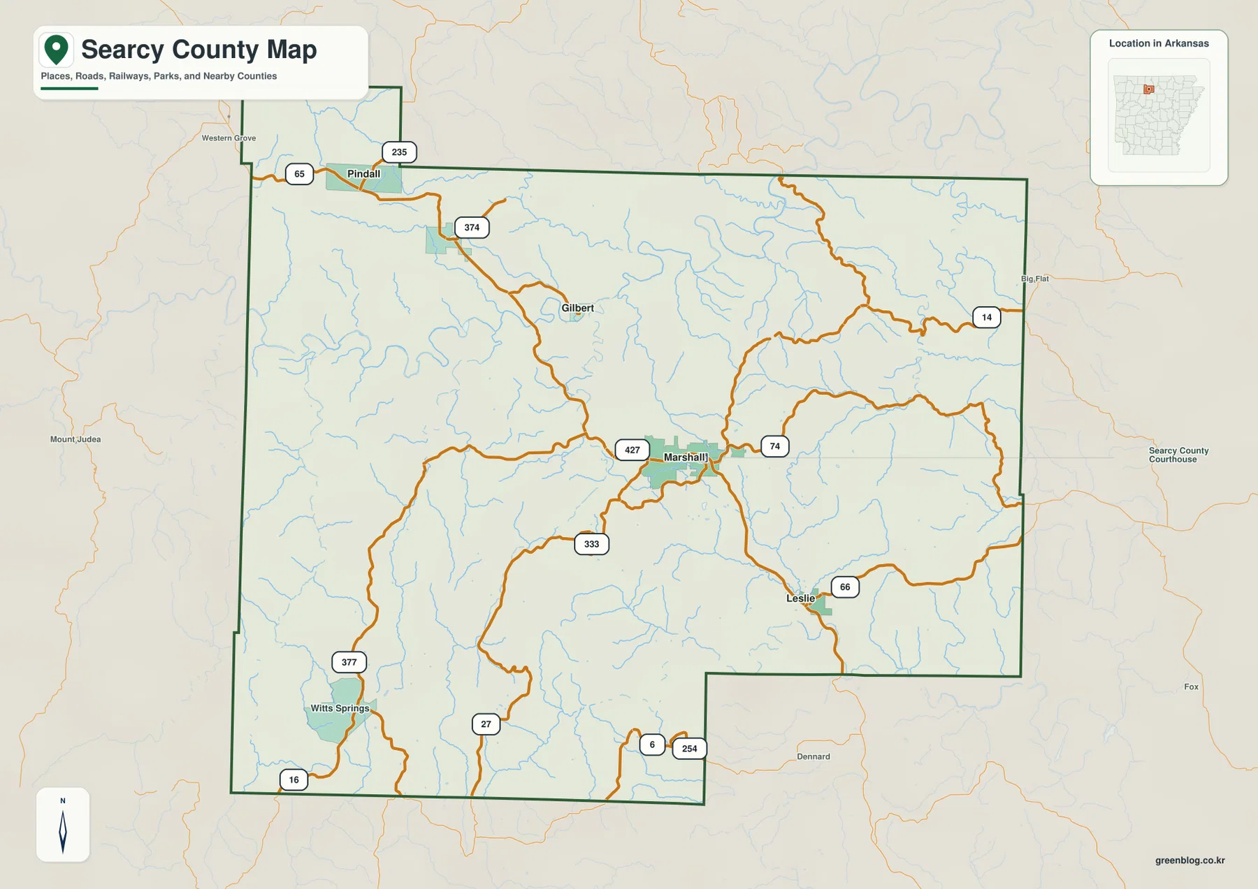
Marshall occupies a central position and is the easiest place to use as an orientation point. Highways 27, 74, 333, and 427 meet or pass close to the city, sending traffic toward different parts of the county. Leslie sits southeast of Marshall along the Route 74 and Route 66 area, while Witts Springs is much farther southwest. To the northwest, the settlement pattern stretches through Gilbert and St. Joe toward Pindall near the US 65 corridor.
The county boundary is also irregular rather than rectangular. A small northwestern extension reaches toward Pindall, while the southeastern side steps inward before continuing east. Neighboring counties shown around the map include Marion and Baxter to the north, Newton and Van Buren to the west, Pope to the south, and Stone and Boone on the eastern side. That context is useful when a road or stream continues beyond Searcy County and disappears from the local map.
The city pattern runs from Leslie southeast of Marshall to Pindall in the northwest
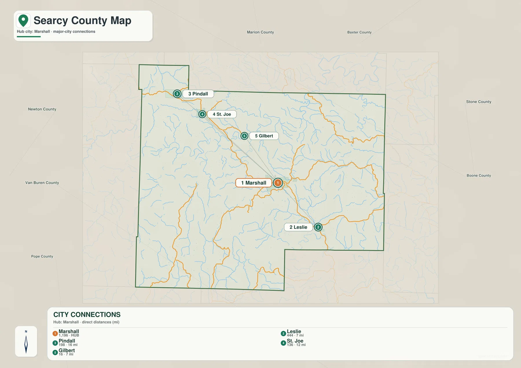
The city-connections map uses Marshall as its hub. Leslie is the nearest of the highlighted communities to the southeast, while Gilbert, St. Joe, and Pindall line up progressively farther to the northwest. This creates a diagonal settlement pattern across the county rather than a tight cluster of towns around one urban center. The map is especially helpful for readers who want to know which direction to travel before looking at individual road turns.
The connector labels are straight-line distances, not driving distances. Roads in Searcy County have to follow valleys, cross ridges, and wind around steep ground, so an actual trip can be longer than the line printed between two places. Witts Springs is visible on the county reference map but is not one of the main connectors in this city diagram, which is another reason to use the two maps together instead of treating either one as a complete transportation map.
Buffalo River curves through the northern valleys
The Buffalo River is the dominant water feature in the northern half of Searcy County. On the terrain-and-water map it makes broad bends through low valleys instead of cutting a straight east-west line. Mill Creek, Tomahawk Creek, and Dry Creek approach the river from the northwestern uplands, while other tributaries enter from the hills farther east. The river’s shape is one of the clearest clues that the landscape is deeply dissected by ridges and valleys.
South of the Buffalo, the drainage network becomes a dense mesh of smaller streams. Bear Creek and Forest Creek cross the middle and southern portions of the county, Big Creek and Long Creek appear toward the east, and Richland Creek, Calf Creek, and Granny Creek drain parts of the southwest. Along the southern side, the Middle Fork Little Red River forms another important corridor. These channels occupy lower ground between the ridges and help explain why roads often bend in similar directions.
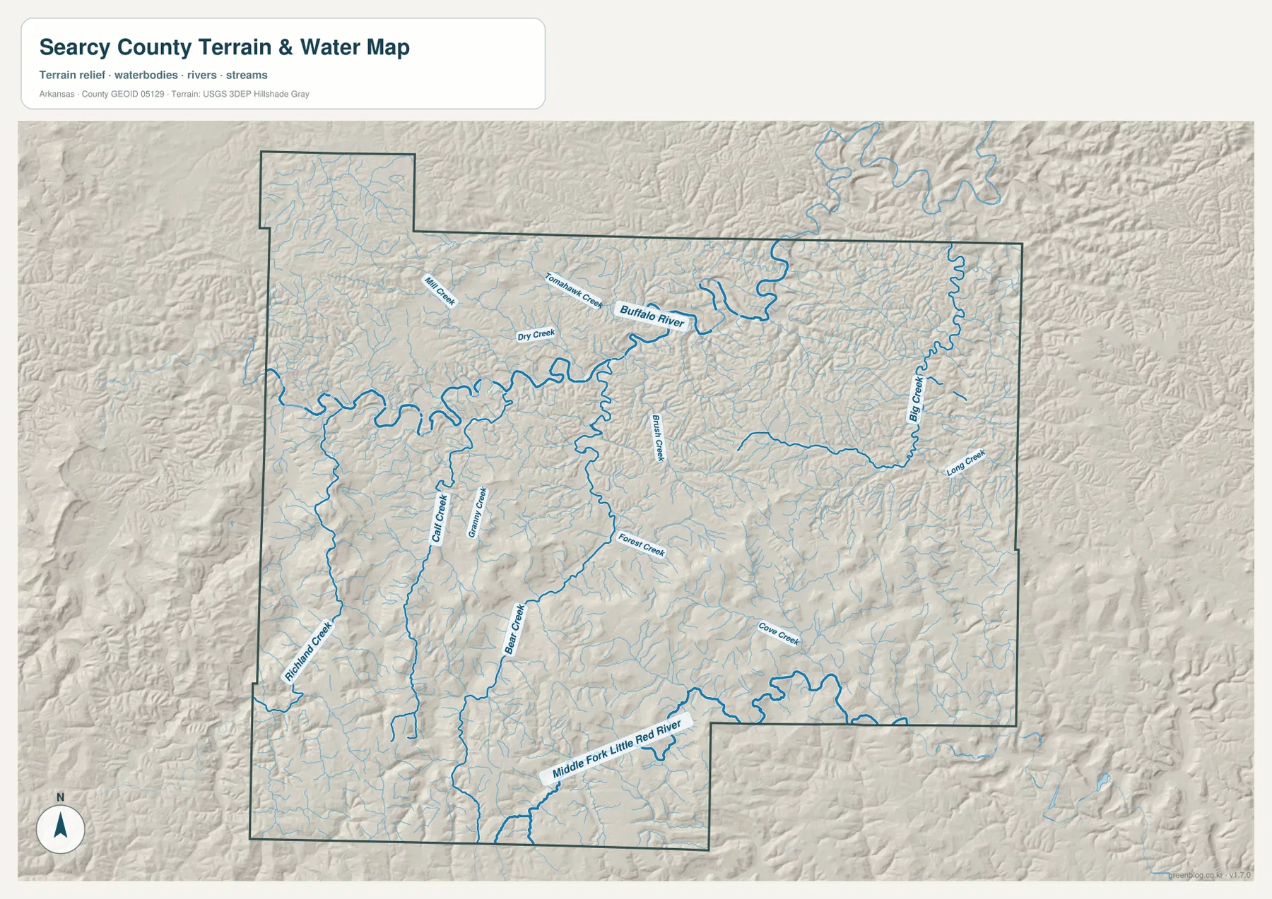
This is a geographic water-reference map, not a floodplain, parcel, legal-boundary, or navigation chart. It works well for identifying the relative position of streams and valleys, but current flood hazards, access rules, and boating conditions should be checked with the appropriate official agency before a trip or property decision.
Higher southern ridges contrast with the Buffalo River corridor
The elevation map gives Searcy County a very different appearance from the road map. The mapped elevation surface has an actual range of roughly 140 to 670 meters and a mean near 355 meters. Brown and tan areas mark higher ground, which is especially prominent across the south and southwest, while the lower Buffalo River corridor forms a long green band through the northern half of the county. Numerous narrow valleys branch away from the main river and cut into the surrounding uplands.
Marshall lies in rolling middle-elevation terrain rather than on the highest southern ridges. Moving south and southwest brings more frequent high crests and sharper relief, while areas near the Buffalo River drop into lower valley floors. This contrast helps explain both the winding road network and the dispersed settlement pattern. A place that looks close on a simple county outline can be separated from another community by a ridge system that makes the real route less direct.
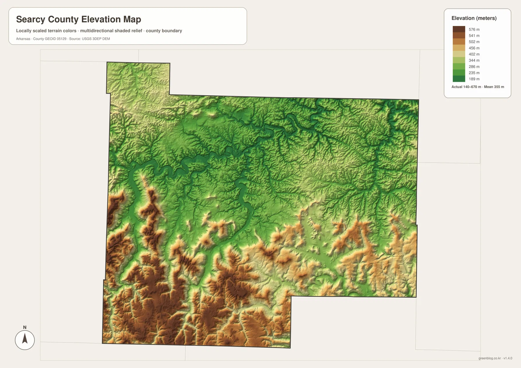
The elevation surface is generalized for county-scale comparison. It should not be treated as survey-grade or engineering-grade elevation for a building site, road project, or property boundary. Those uses require more precise site-specific measurements.
US 65 and the Marshall roads connect the county to Buffalo River country
US 65 appears near Pindall in the northwestern part of the county, while Marshall is served by a set of state highways that spread in several directions. Route 74 carries the map eastward from Marshall and toward Leslie, Route 27 reaches south, and smaller numbered routes connect communities and valleys that are away from the main highway. Witts Springs in the southwest is reached through another branch of this network rather than through the northwestern US 65 corridor.
Searcy County’s official website describes the county as a place where the Ozark Mountains and local communities meet. The National Park Service places the Tyler Bend visitor center about eight miles north of Marshall on Highway 65, which shows why Marshall is a practical orientation point for visitors heading toward Buffalo National River. On a trip-planning map, finding Marshall first makes it easier to understand whether the next destination lies toward the river, Leslie, the northwestern communities, or the higher country to the south.
Match the map to the question you need to answer
For a first look at Searcy County, start with the county reference map. It combines community names, numbered roads, streams, and the boundary in one view, making it the best general orientation sheet. Move to the city-connections map when the main question is how Marshall relates to Leslie, Gilbert, St. Joe, or Pindall. Because its lines show direct distances, it is best used for comparison rather than turn-by-turn travel.
The terrain-and-water map is the better choice for Buffalo River, creek valleys, and the southern drainage system. The elevation map adds another layer by separating high ridges from low valleys at a glance. For a classroom lesson or a county profile, pairing the reference map with either the water or elevation map can show not only where a place is, but also why its roads and streams follow the shapes they do.
Important limits when using the maps
Each map emphasizes a different part of the county. The road-and-place map is intentionally busier, while the terrain-and-water view reduces transportation detail so streams and relief are easier to see. The elevation layer summarizes county-scale height differences and the city diagram simplifies selected place-to-place relationships. None of them is meant to replace every specialized government map for navigation, property research, engineering, or hazard planning.
For ordinary reference, however, the four views work well together. A reader can locate Marshall on the reference map, see the Buffalo River north of it, compare nearby communities in the city diagram, and then use elevation shading to understand the ridges between those places. That sequence gives a more complete picture of Searcy County than a boundary outline alone.
Frequently Asked Questions
What is the main town to use for orientation in Searcy County?
Marshall is the county seat and the most useful orientation point on these maps. Several numbered highways meet around it, with Leslie to the southeast and Gilbert, St. Joe, and Pindall extending toward the northwest.
Where does the Buffalo River run through Searcy County?
The Buffalo River curves through the northern half of the county. Marshall lies south of the river, while the Gilbert and St. Joe area is closer to the river corridor in the northwestern part of the county.
Can the elevation map be used for construction measurements?
No. It is a county-scale reference that shows broad differences between ridges and valleys. Construction, surveying, and engineering work require more precise site-specific elevation measurements.
Map File Information
The ZIP contains four original high-resolution JPG maps for Searcy County: the county reference, city connections, terrain and water, and elevation views.
- Included Files: County reference, city connections, terrain and water, and elevation maps
- Printable Size: A3 landscape
Related Maps
Sources and References
- Searcy County official website – county government and local overview
- National Park Service: Buffalo National River – visitor and Tyler Bend information
- U.S. Census Bureau TIGER/Line – geographic boundary and transportation reference data
- USGS National Hydrography – river and stream reference data
- USGS 3D Elevation Program – elevation and terrain data
Green Map creates custom-edited map images using open geographic data sources such as geoBoundaries, Natural Earth, OpenStreetMap, and government open data.
These maps are edited visual materials, not raw data files, and are provided for education, documents, presentations, and graphic reference.