Grenada County sits in north-central Mississippi where a major highway corridor and a large reservoir share the same county. The city of Grenada is the clear transportation and settlement center, with I-55 and U.S. 51 running north to south, while Grenada Lake spreads across a large part of the eastern side. The maps on this page make it easy to compare roads, the city pattern, waterways, and terrain, and the matching high-resolution A3 JPG files are available as a downloadable ZIP for printing or reuse.
The county changes noticeably from west to east. Broad low ground occupies much of the western side, the Yalobusha River crosses toward Grenada Lake, and hillier terrain appears around the northern, eastern, and southeastern edges. That combination makes the county more varied than a single road map suggests. Looking at the four supplied map themes together shows how Grenada, the reservoir, tributary valleys, and higher ridges fit into one compact area.
Table of Contents
Grenada is the road hub between I-55 and the lake
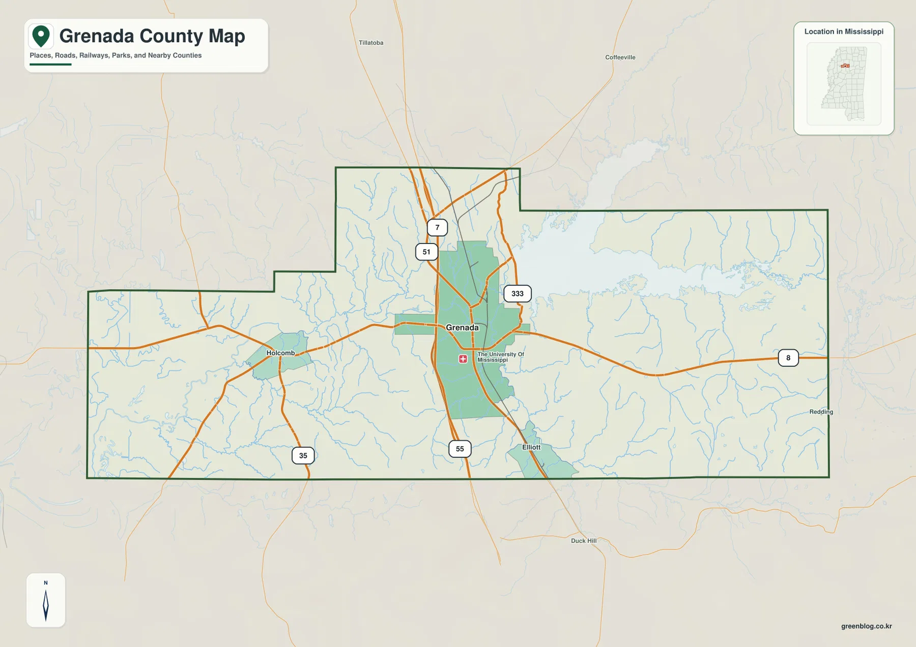
The county map places Grenada near the center of the road network. I-55 and U.S. 51 run through the city on a north-south line, while Mississippi Highway 8 crosses from the Holcomb side through Grenada and continues east toward Grenada Lake. Mississippi 7 enters from the north, Mississippi 333 is marked near the city, and Mississippi 35 appears farther southwest. These routes make Grenada much easier to locate than the smaller place labels around the county.
The county outline is irregular rather than rectangular. A northern section projects upward, and the eastern half widens around the reservoir. Holcomb helps mark the western side, while Elliott appears south of Grenada. The map also labels Yalobusha County to the north, Calhoun and Webster counties to the east, Tallahatchie and Leflore counties to the west, and Carroll and Montgomery counties to the south. Those neighboring labels are useful when the goal is to understand where a road leaves Grenada County rather than simply finding the city itself.
The city index shows one dominant urban center
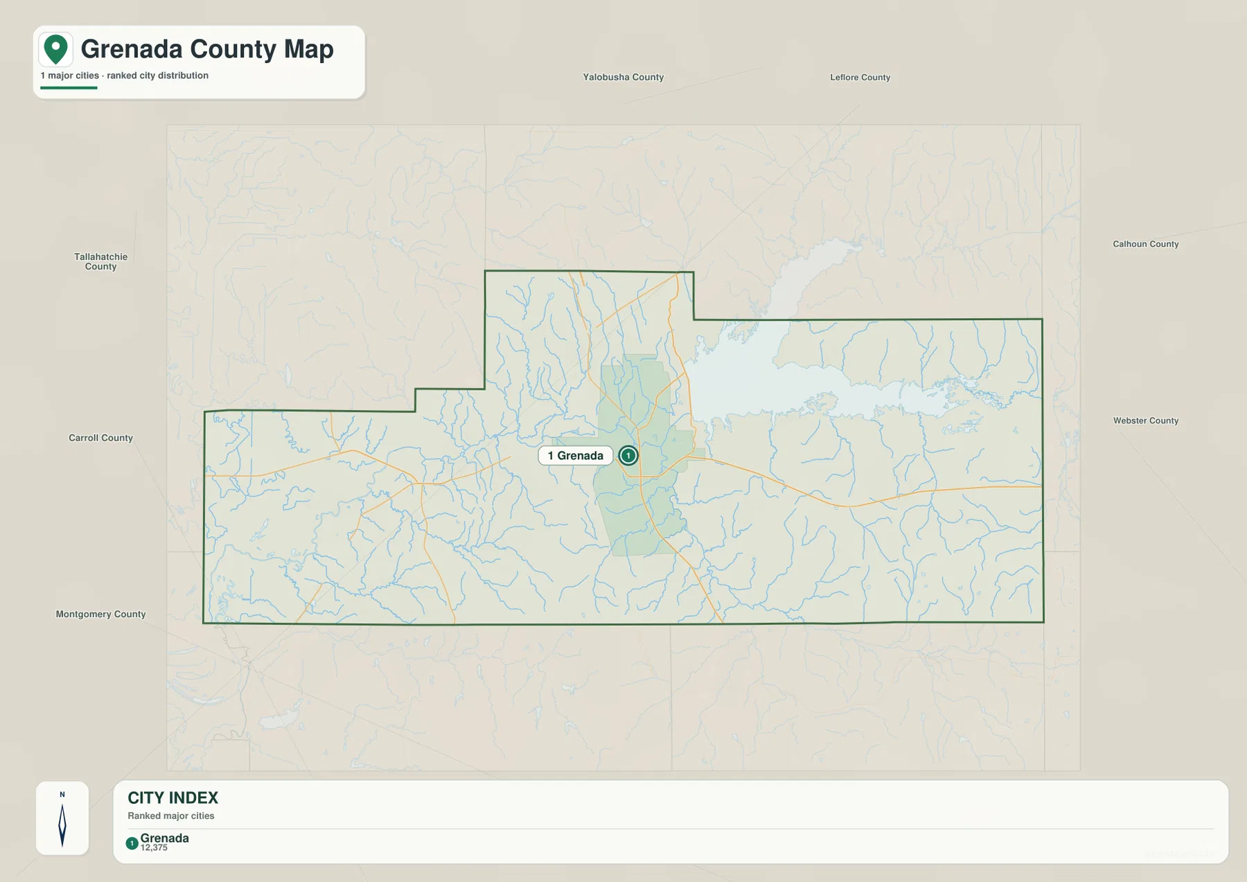
The city map is unusually simple: Grenada is the only place shown in the ranked major-city index. The label at the bottom lists Grenada with a value of 12,375. Because the map does not state the year for that city-index number, it is best treated as the value printed on this map rather than as a current population estimate. The important visual point is that the county does not show several similarly ranked cities competing for attention.
Grenada is positioned slightly east of the county’s midpoint, close to the highway corridor and immediately west of the reservoir area. The surrounding county labels help show how central that location is for regional travel: Yalobusha County lies north, Calhoun and Webster are to the east, and Carroll and Montgomery are to the south. For a presentation that only needs the location of the principal city, this map is much cleaner than the full county map. For route planning or road context, the county map provides the missing detail.
Grenada Lake reshapes the eastern half of the county
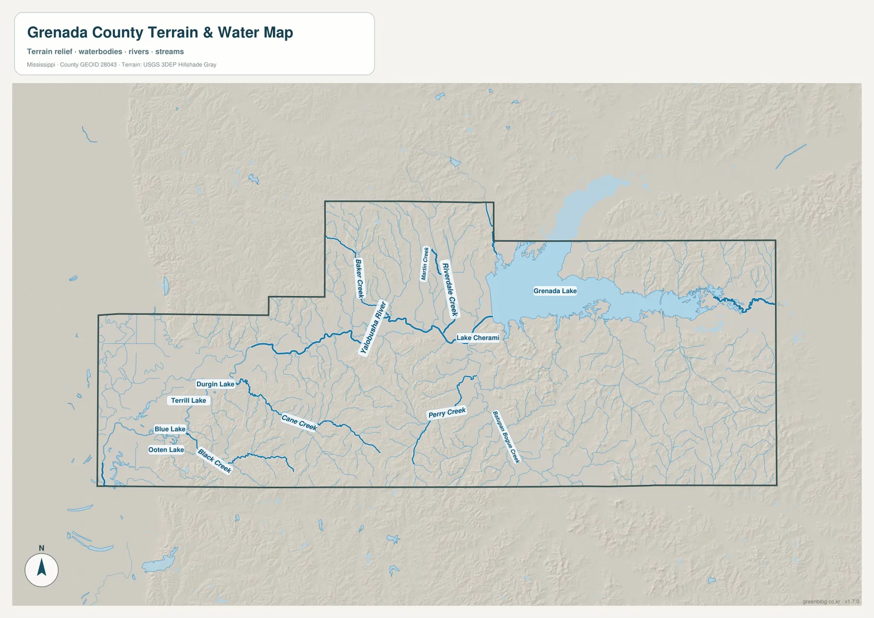
The water map is dominated by Grenada Lake, which occupies a broad area in the east and narrows into branching arms around surrounding hills. The Yalobusha River approaches the reservoir from the west, and several smaller streams feed the same low ground. Baker Creek and Riverside Creek are labeled north of the river corridor, while Lake Cherami sits close to the western side of Grenada Lake. The dense network of unnamed tributaries around the reservoir makes the eastern county look very different from the simpler highway pattern on the county map.
Smaller lakes and creeks are especially visible in the west. Durgin Lake, Terrill Lake, Blue Lake, and Ooten Lake appear within a relatively compact area, with Cane Creek and Black Creek crossing the surrounding lowlands. Perry Creek is labeled farther south-central. This is a reference map for the position of rivers, lakes, and streams; it is not a flood-risk map, legal shoreline survey, or navigation chart. Anyone making a property, engineering, or safety decision should use the relevant official product for that purpose.
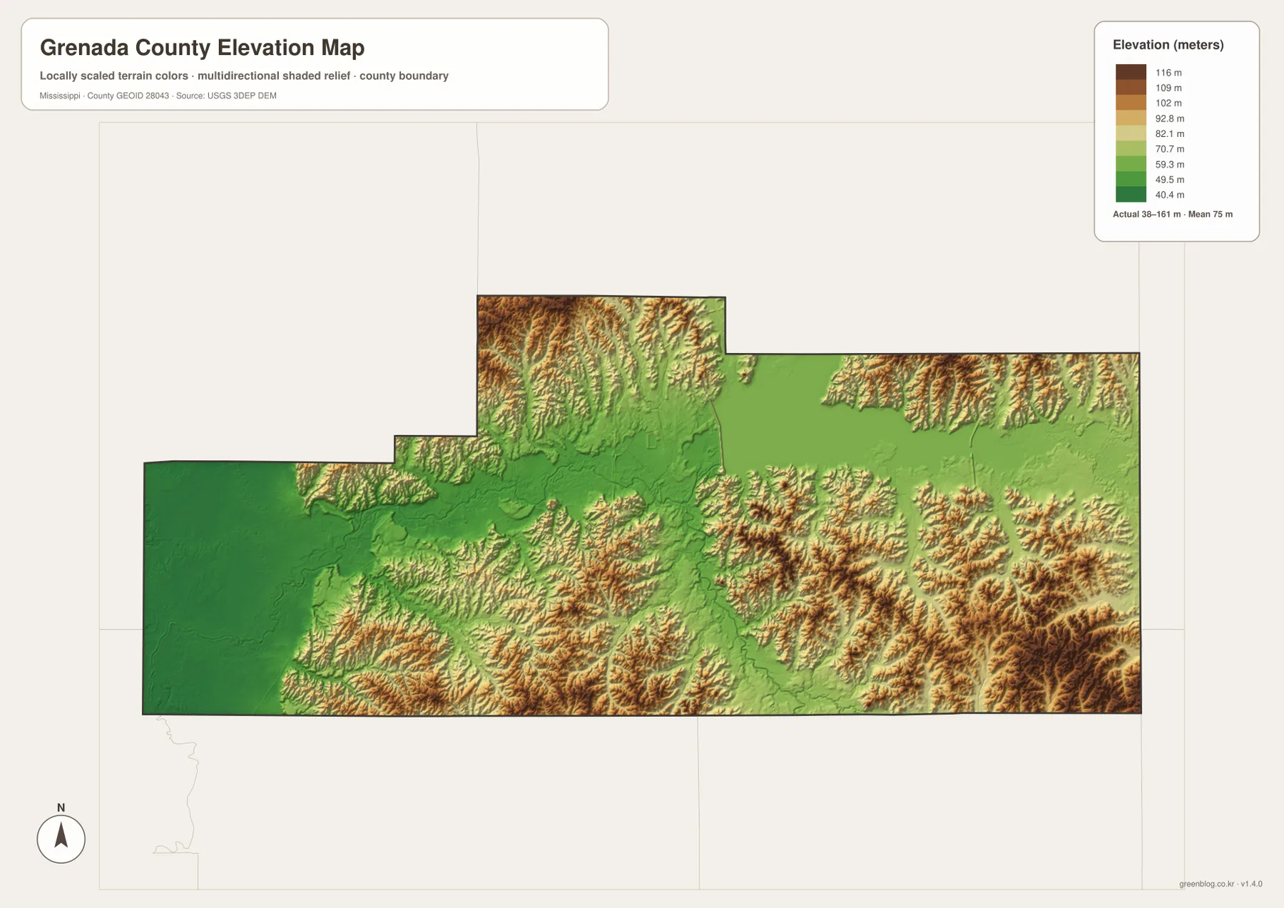
Elevation rises from western lowlands into broken hill country
The elevation map gives an actual county range of about 38 to 161 meters, with a mean elevation of 75 meters. Dark green covers much of the western side and the main river valley, identifying the lowest broad areas. Higher colors become more common toward the north, around the eastern side of Grenada Lake, and across the southeast. The result is a county where a low central and western corridor is bordered by more dissected hills.
The contrast is particularly clear south and southeast of the reservoir, where narrow valleys cut between closely spaced ridges. The difference between the displayed low and high values exceeds 120 meters, but the map is intended for county-scale terrain reference rather than parcel-level surveying. It is useful for comparing relative height and understanding why streams occupy certain valleys; construction design, drainage calculations, and precise site elevations require more detailed data.
County figures add context to the map
- County seat: Grenada
- FIPS code: 28043
- 2020 Census population: 21,629
- July 2025 population estimate: 20,868
- 2025 Gazetteer land area: 422.113 square miles
- 2025 Gazetteer water area: 27.291 square miles
- Density using 2020 population and 2025 land area: about 51.2 people per square mile
The 2020 Census count and the July 2025 estimate refer to different dates, so they should not be treated as measurements from the same year. The water-area figure is also notable because Grenada Lake occupies such a conspicuous share of the map. Combined with the city index, these numbers reinforce a simple geographic picture: one principal urban center sits beside a large reservoir within a county that extends from low western ground into hillier eastern terrain.
Choose the file that matches the question
Use the county map when you need I-55, U.S. 51, Mississippi 8, the county boundary, or nearby place labels. The city map is better when a clean graphic showing Grenada as the principal city is enough. For Grenada Lake, the Yalobusha River, western lakes, and tributaries, the water map carries much more detail. The elevation map is the better choice for explaining where the county is low and where the hills become more pronounced.
The maps can also be combined without repeating the same information. A road-focused report can use the county map first and add the water map only when the reservoir or river corridor matters. A terrain lesson can pair the water and elevation maps to show how lower valleys line up with streams. The on-page WebP images are convenient for viewing, while the downloadable JPG files are intended for larger print, editing, and presentation use.
Frequently Asked Questions
Where is Grenada Lake in relation to the city of Grenada?
Grenada Lake lies east and northeast of the city. Mississippi Highway 8 provides a clear eastward reference on the county map, while the water map shows the lake together with the Yalobusha River and nearby Lake Cherami.
Why does the city map show only Grenada as a ranked major city?
The supplied city map uses a ranked major-city index and lists only Grenada. That does not mean there are no smaller communities in the county; it means Grenada is the only place selected by the map’s major-city ranking.
Which parts of Grenada County are lowest and highest on the elevation map?
The broad western side and main river corridor are the lowest areas, while more elevated and broken hills appear around the northern, eastern, and southeastern parts of the county. The displayed range is about 38 to 161 meters, with a mean of 75 meters.
Map File Information
The county, city, water, and elevation maps shown above are packaged as high-resolution A3 JPG files. Download the ZIP when you need the original images for printing, documents, classroom material, or presentations.
- Included Files: county map, city map, water map, elevation map
- File Type: JPG
Related Maps
Sources and References
- U.S. Census Bureau Grenada County QuickFacts
- U.S. Census Bureau Gazetteer Files
- Mississippi Department of Transportation official highway map
- U.S. Army Corps of Engineers Grenada Lake
- USGS National Hydrography
- USGS 3D Elevation Program
Green Map creates custom-edited map images using open geographic data sources such as geoBoundaries, Natural Earth, OpenStreetMap, and government open data. These maps are edited visual materials, not raw data files, and are provided for education, documents, presentations, and graphic reference.