Greene County in southeastern Mississippi is easiest to understand by starting with Leakesville, then widening the view toward McLain, the Alabama side of the county, and the many streams that cut through the interior. The map set on this page shows roads, the two ranked city labels, named water features, and elevation. Matching high-resolution A3 JPG files are also available in one ZIP for download.
This is not a county where a dense chain of towns fills the map. Leakesville stands out as the main reference point, McLain sits well to the west, and much of the space between them is crossed by creeks and local roads. The elevation map adds another layer: the county is not mountainous, yet stream valleys and surrounding hills repeatedly rise and fall across a range of roughly 12 to 115 meters.
Table of Contents
Leakesville organizes a road network that spreads in several directions
On the county map, Leakesville is the clearest place to begin. MS 57 runs north from the area, MS 63 approaches from the west and southwest, and other state routes branch toward the eastern side. US 98 lies along the southern edge of the county, creating a major east-west reference near McLain and Leaf. Farther north, MS 42 crosses the upper part of the county and gives the map a second broad east-west route.
McLain helps define the western side of Greene County, while the State Line label near the east side makes the Mississippi–Alabama edge easy to recognize. MS 198 and MS 594 add local connections in the lower half of the map. Because the road system is spread over a large rural area, it is more useful to compare the direction of these routes from Leakesville than to expect a tightly connected urban grid.
The city index emphasizes two places with very different sizes
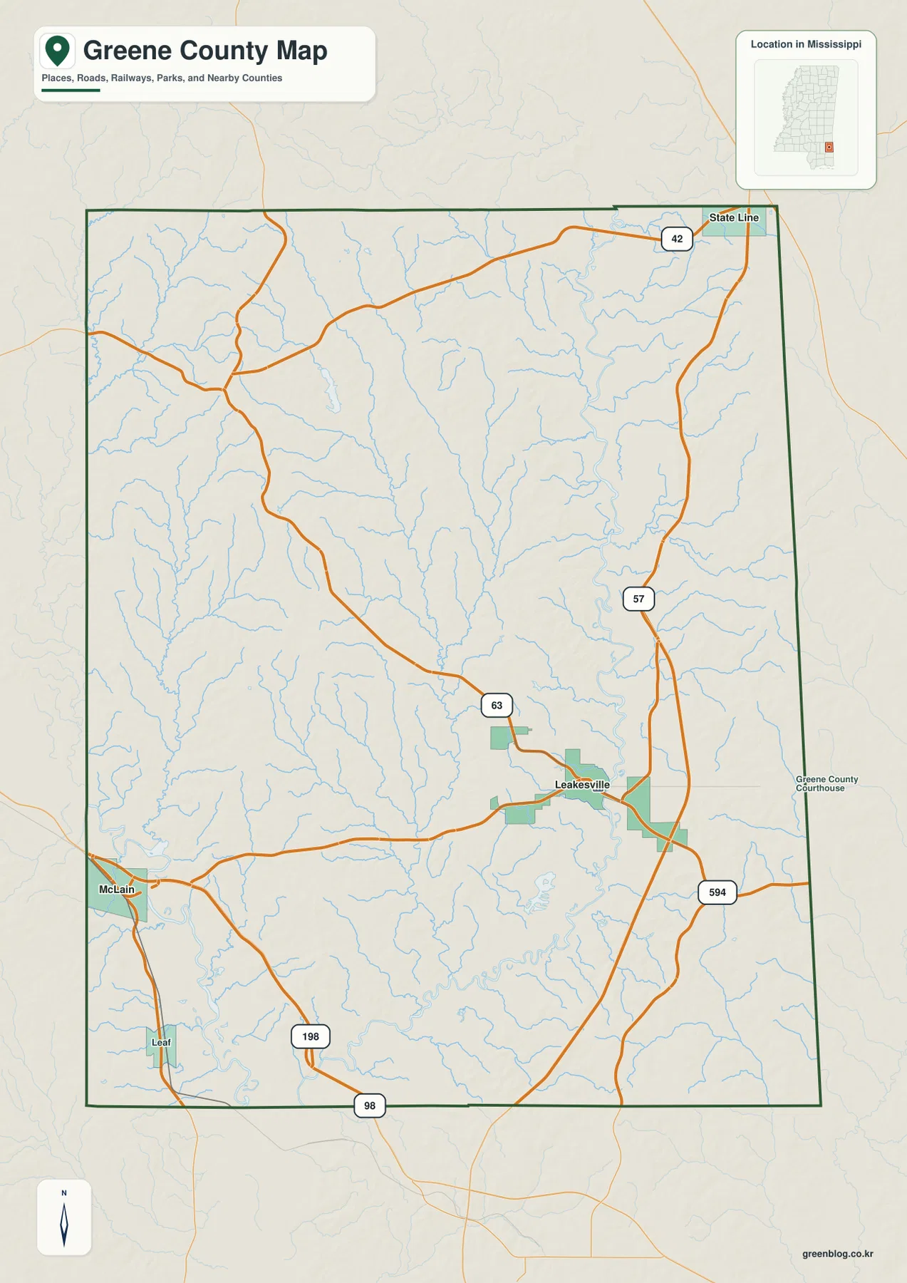
The city map deliberately keeps the settlement labels simple. It ranks Leakesville first and McLain second, with the index showing 4,959 for Leakesville and 416 for McLain. The map itself does not print a year beside those figures, so they are best treated as the values used for this city index rather than as a dated population claim.
Their positions matter as much as the numbers. Leakesville lies in the eastern half of the county, while McLain sits close to the western boundary. The large space between them is filled by branching waterways and a relatively light road network. Wayne County is labeled to the north, Perry County to the west, and George County along the lower western and southern side, giving useful context for trips that continue beyond Greene County.
Leaf River is only one part of a dense creek-and-lake network
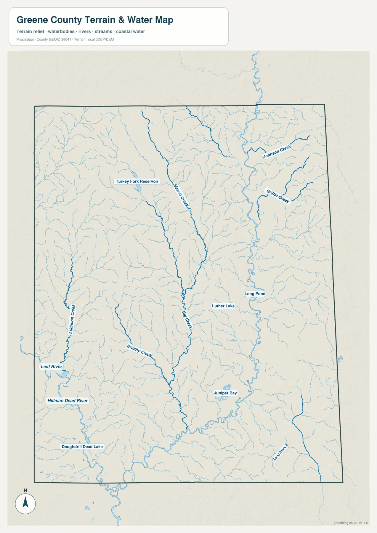
The terrain and water map is much busier than the city map because small waterways appear across nearly the entire county. Leaf River is labeled on the western side. Allison Creek and Bushy Creek feed that side of the drainage, while Mason Creek and Big Creek run through the interior. Johnson Creek and Griffin Creek stand out farther east. Numerous unnamed tributaries fill the spaces between the labeled channels.
Several named water bodies add useful landmarks. Turkey Fork Reservoir appears in the northwestern quarter, while Luther Lake and Long Pond sit farther east. Juniper Bay is labeled in the southern half, and the southwest includes Hillman Dead River and Daughdrill Dead Lake. These features are especially helpful when a road name alone is not enough to place a rural location within the county.
The pattern also explains why the county map contains so many pale blue lines even where towns are absent. Greene County is crossed by a large number of small valleys. For outdoor orientation or general geographic study, a creek or small lake may be a more reliable local reference than a distant municipality. The water map should not be used as a flood, navigation, or property-boundary map, but it is useful for understanding how the county is divided by drainage features.
Elevation ranges from about 12 to 115 meters, with valleys cutting between low hills
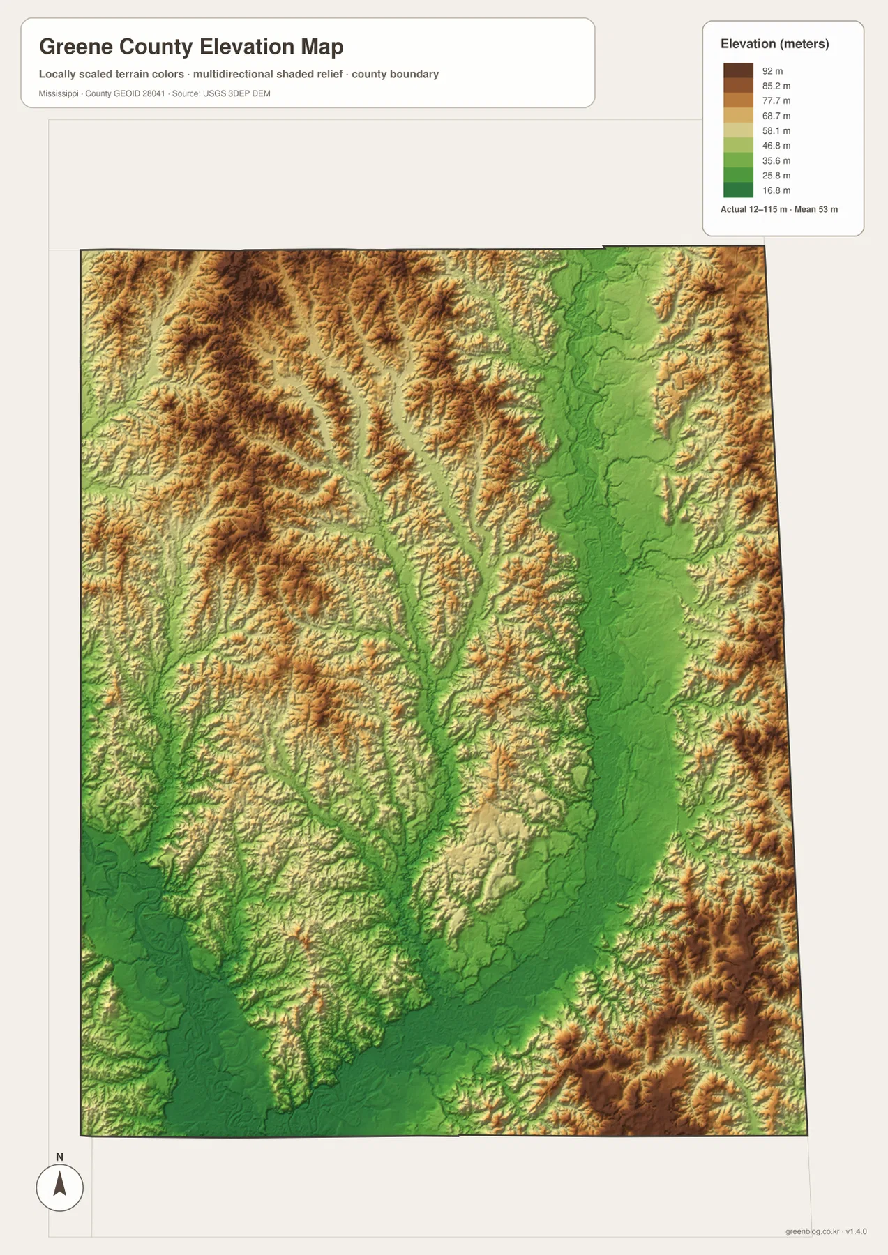
The elevation map reports an actual range of about 12 to 115 meters and a mean elevation of 53 meters. Green areas follow lower ground, especially broad valley floors and stream corridors. Tan and brown areas mark higher ridges and hills. The northwestern part of the county contains many closely spaced ridges, while lower green corridors extend through the center and eastern side.
A difference of roughly one hundred meters from low to high does not make Greene County a mountain landscape, but it is enough to create repeated local relief. Narrow creek valleys separate higher ground, and the shaded surface shows many short ridges rather than one dominant high range. When the elevation map is compared with the water map, many of the lowest bands line up with the same drainage corridors.
This is useful when a visitor wants to understand why two nearby points can sit on different terrain even though the county as a whole is relatively low. It also helps distinguish the broad lower areas from the more dissected hill country. The map is intended for geographic reference, not engineering, surveying, or site-level elevation decisions.
County statistics fit the widely spaced settlement pattern
- County seat: Leakesville
- FIPS code: 28041
- 2020 census population: 13,530
- July 2025 population estimate: 13,707
- 2025 Gazetteer land area: 712.738 square miles
- 2025 Gazetteer water area: 5.958 square miles
- Density using the 2020 count and 2025 land area: about 19.0 residents per square mile
The 2020 census count and the July 2025 estimate refer to different dates and should not be treated as a single-year growth calculation. The more useful map connection is scale: more than 700 square miles of land are shared by a relatively small population. That helps explain why the city map has only two ranked places and why so much of the county map is occupied by roads, forested-looking background, and streams rather than continuous development.
Choose the file by the question you need to answer
Use the county map when the main goal is to locate Leakesville, McLain, the Alabama side, or the major routes. The city map is cleaner when only the ranked settlement locations matter. The water map is the better choice for Leaf River, named creeks, lakes, and reservoirs. The elevation map adds the low-valley and hill contrast that is hard to infer from roads alone.
For a presentation, a report, or a printed reference sheet, it is usually better to start with the county map and add one specialized map only where it contributes new information. A water feature discussion does not need the elevation map unless relief matters, and a simple route explanation does not need every creek label. This keeps the page readable while still making the complete set available when more context is needed.
Frequently Asked Questions
How can I tell Leakesville and McLain apart on the maps?
Leakesville is in the eastern half of Greene County and sits where several state routes come together. McLain is much farther west near the county boundary. The city map isolates both places, while the county map adds US 98, MS 63, MS 198, and other routes for orientation.
Which water features are labeled besides Leaf River?
The water map labels Mason Creek, Big Creek, Johnson Creek, Griffin Creek, Allison Creek, and Bushy Creek, along with Turkey Fork Reservoir, Luther Lake, Long Pond, Juniper Bay, and other smaller features. These names help locate rural areas that are far from the two ranked cities.
What does the elevation map show about Greene County?
It shows an actual elevation range of about 12 to 115 meters with a mean of 53 meters. Lower green corridors follow stream valleys, while higher tan and brown areas form ridges and hills between them. The map is useful for broad terrain comparison rather than survey-grade measurement.
Map File Information
The ZIP contains the Greene County county map, city map, water map, and elevation map as high-resolution JPG files matching the previews on this page.
- Included Files: County map, city map, water map, elevation map
Related Maps
Sources and References
- U.S. Census Bureau QuickFacts for Greene County
- U.S. Census Bureau Gazetteer Files
- Mississippi Department of Transportation official highway map
- USGS National Hydrography
- USGS 3D Elevation Program
Green Map creates custom-edited map images using open geographic data sources such as geoBoundaries, Natural Earth, OpenStreetMap, and government open data.
These maps are edited visual materials, not raw data files, and are provided for education, documents, presentations, and graphic reference.