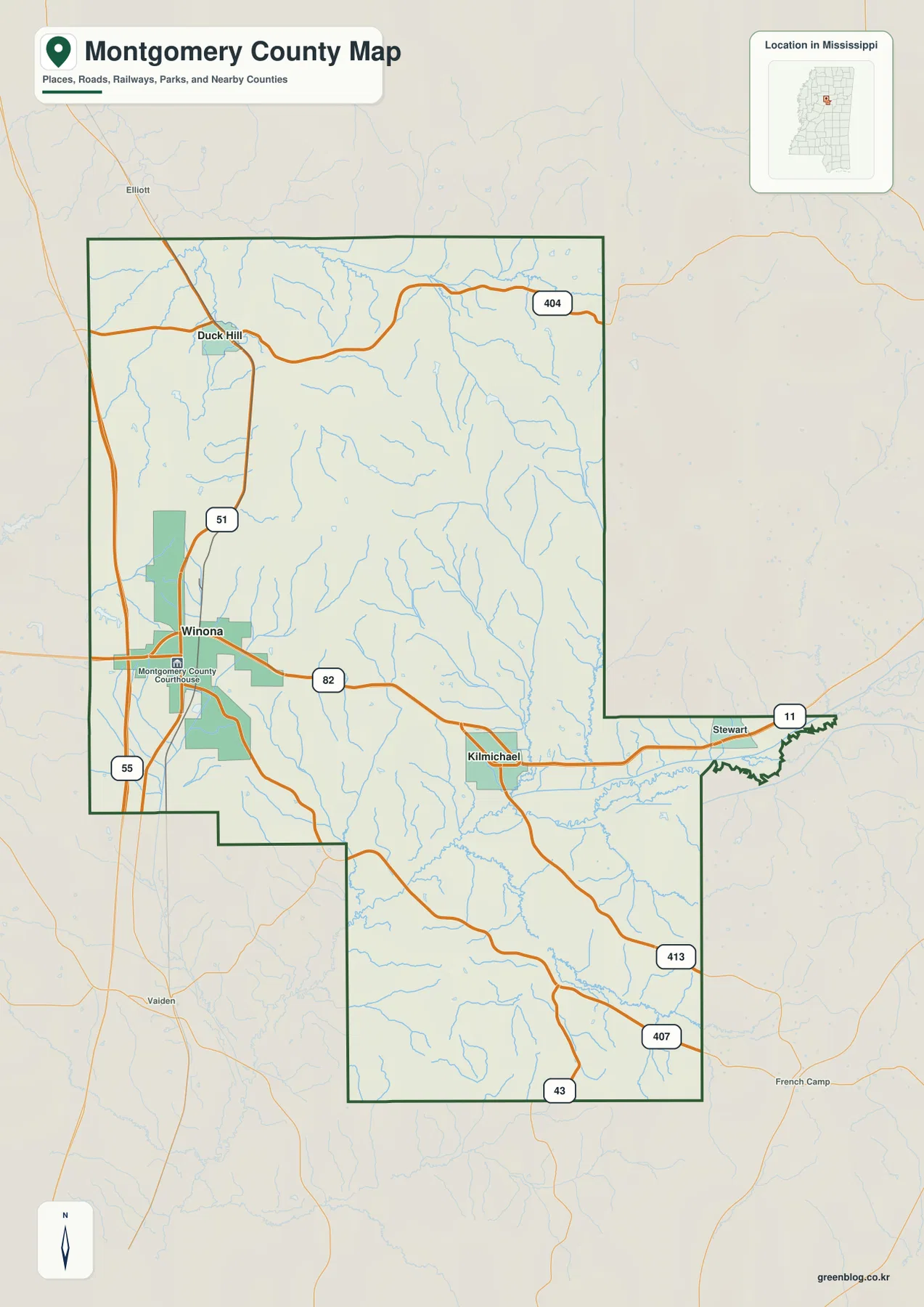
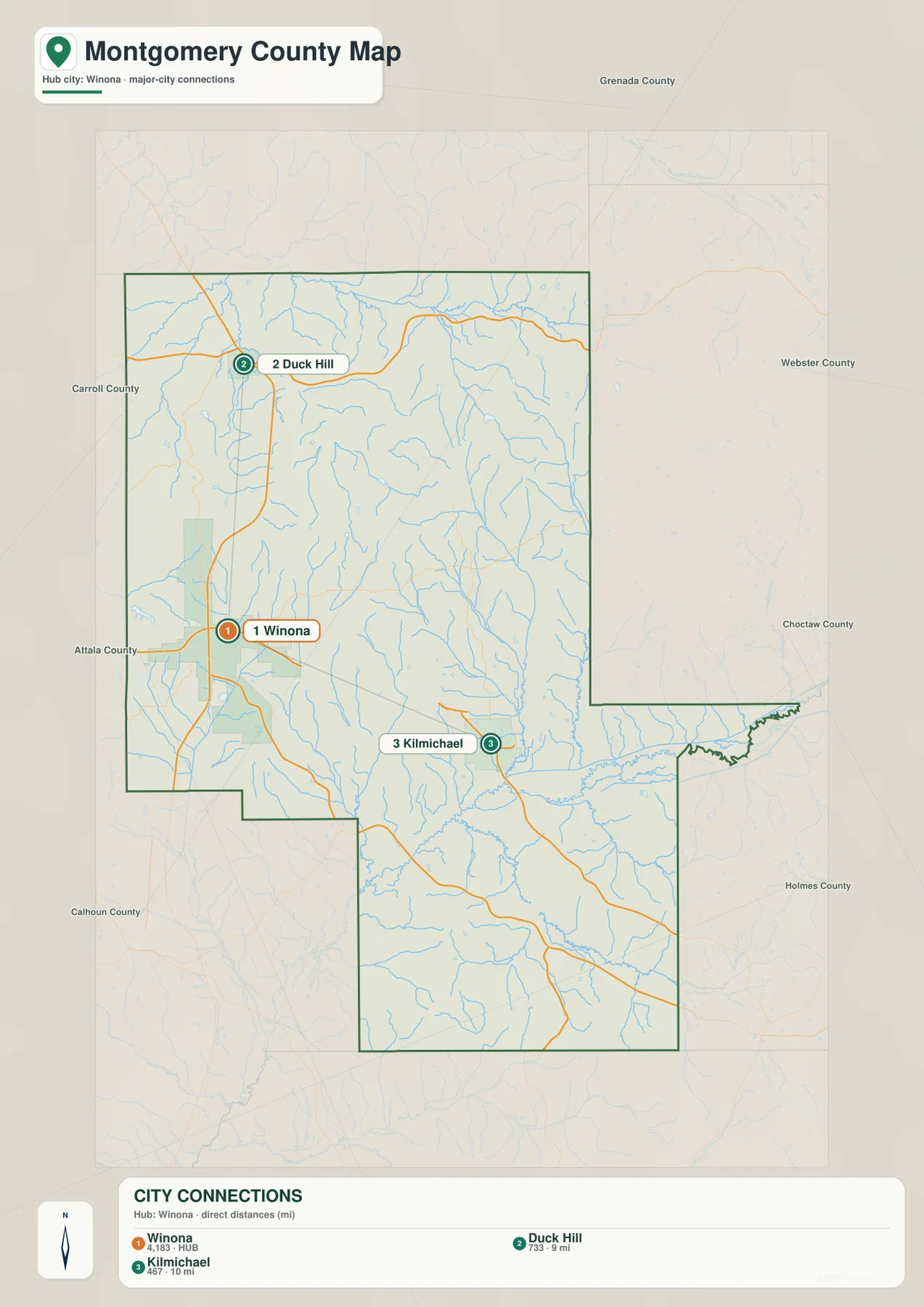
Montgomery County, Mississippi is easiest to understand from Winona, where the county’s main east-west and north-south routes come together. The maps on this page show the county boundary and roads, the relative positions of Winona, Duck Hill, and Kilmichael, named waterways feeding the Big Black River, and a hill-and-valley elevation surface. The same four maps are also available as high-resolution A3 JPG files in a downloadable ZIP.
This is not a county with one huge lake or a single flat landscape. US 82 crosses through Winona toward Kilmichael, US 51 runs north toward Duck Hill, and I-55 stays close to the western side of the county. Away from those corridors, many small creeks cut through a strongly dissected hill country. The elevation map gives an actual range of about 62 to 180 meters, while the water map shows how lower valleys lead toward the Big Black River system in the southeastern part of the county.
Table of Contents
Start with Winona at the county’s main crossroads
Winona is the county seat and the clearest orientation point on the general county map. US 82 passes east-west through the city, while US 51 provides the north-south route toward Duck Hill. I-55 runs close to the western edge, giving the Winona area a direct connection to a much larger north-south corridor. Once those three routes are located, the rest of Montgomery County becomes easier to place.
The northern part of the map also shows MS 404 near Duck Hill. Farther south and east, state routes such as MS 407, MS 413, and MS 43 follow the long lower portion of the county, while US 82 continues across the county toward Kilmichael. A short eastern extension includes the MS 11 corridor. The map is designed for county-scale orientation rather than every local road, so these larger numbered routes are the most useful references for matching communities to the county boundary.
County facts that help put the maps in scale
| Item | Value |
|---|---|
| County | Montgomery County, Mississippi; FIPS 28097 |
| County seat | Winona |
| 2020 census population | 9,822 |
| July 2025 population estimate | 9,354 |
| 2025 Gazetteer area | 406.981 sq mi land; 0.908 sq mi water |
| Density using 2020 population and 2025 land area | About 24.1 residents per sq mi |
| City-map references | Winona, Duck Hill, Kilmichael |
| Elevation-map range | About 62–180 m; mean about 113 m |
The population figures come from different reference dates, so they should not be treated as one same-year dataset. The 2020 census is a decennial count, while the July 2025 figure is a later estimate. The density value is likewise a county-wide average based on land area; it does not mean settlement is spread evenly. On the maps, Winona is the most prominent built-up reference, while broad areas east and south of the city are occupied by smaller communities, wooded ridges, creek valleys, and rural roads.
Duck Hill and Kilmichael sit on different sides of the Winona hub
The city-connections map reduces the county to three labeled community references. Winona is marked as the hub. Duck Hill lies to the north at about 9 miles in straight-line distance, while Kilmichael lies roughly 10 miles from Winona toward the east-southeast. Those figures are direct map distances rather than driving mileage, so a road trip can be longer depending on the route used.
The map’s city index also displays values of 4,183 for Winona, 733 for Duck Hill, and 467 for Kilmichael. They are best treated as the city-level comparison values printed on this map, not as substitutes for the county-wide population figure above. Their geographic positions are the more important part of the graphic: Duck Hill helps anchor the US 51 corridor north of Winona, whereas Kilmichael provides the key town reference along US 82 on the eastern side.
Creeks and small lakes lead toward the Big Black River system
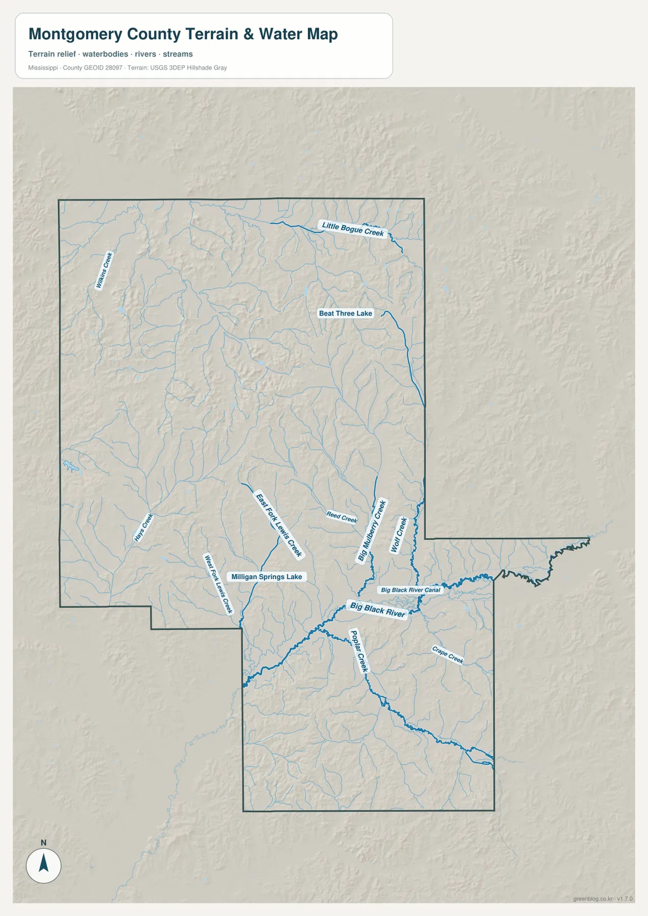
The terrain-and-water map shifts attention away from highways and toward the drainage network. The Big Black River is the most prominent named channel in the southeastern half of the county, with the Big Black River Canal running nearby. Poplar Creek joins the same general low corridor from the south, and Wolf Creek is labeled farther east. Numerous smaller tributaries fill the spaces between the ridges, showing why the county map contains so many blue lines even though large open-water areas are limited.
Two named lakes stand out at this scale. Beat Three Lake appears in the northeastern part of the mapped county, while Milligan Springs Lake is shown closer to the southwest side of the Big Black River corridor. Little Bogue Creek is labeled in the north, and Reed Creek is among the smaller streams identified near the central-eastern drainage. Together, these features describe a landscape of many creek valleys and small water bodies rather than a reservoir-dominated county.
This water map is a location reference, not a flood-hazard, parcel-boundary, or navigation map. Its best use is to identify named rivers, creeks, and lakes and then compare them with the road and elevation maps. A creek that is hard to follow on the general county map becomes much easier to trace here, and the same corridor can then be checked against the lower green areas on the elevation surface.
A 62–180 meter range reveals a closely spaced hill-and-valley landscape
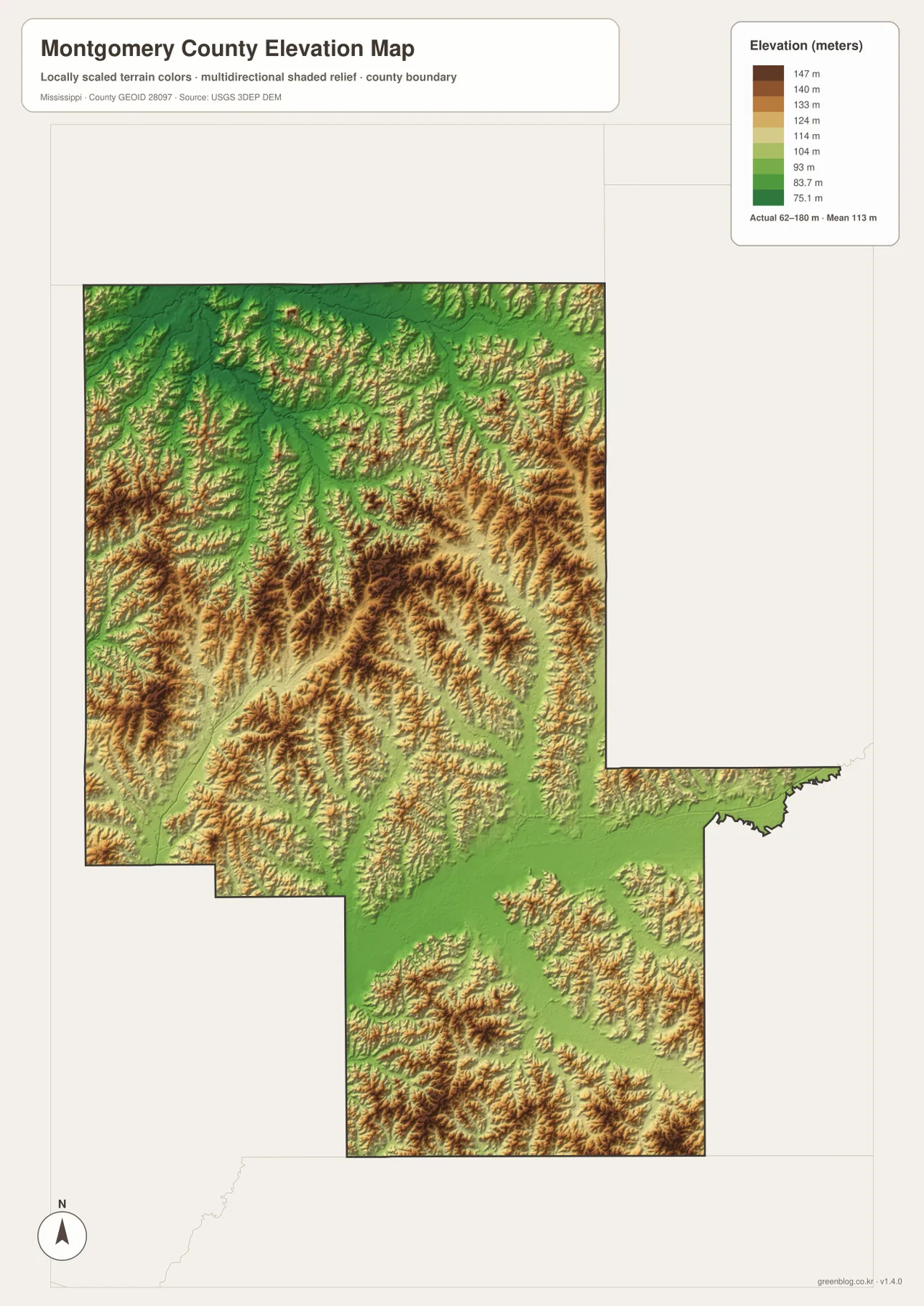
The elevation map reports an actual county range of about 62 to 180 meters and a mean of about 113 meters. Montgomery County is not mountainous, but the relief image is far from uniform. Brown and tan ridges are repeatedly cut by green valleys, producing a textured surface across the northern, central, and southern parts of the county. The short spacing between ridges and valleys is more informative here than the absolute maximum elevation.
Lower green corridors often line up with the drainage seen on the water map, including the broader Big Black River corridor in the lower half of the county. Higher ridges occupy the ground between those channels. Because the pattern occurs in many directions, it would be misleading to describe Montgomery County simply as high on one side and low on the other; the map instead shows a repeated network of uplands separated by creek valleys.
The elevation surface is generalized for county-scale reading. It should not be used as survey-grade elevation for construction, property work, or engineering. Roads and towns are not labeled on this image, so the safest way to compare relief with a place such as Winona or Kilmichael is to locate the community on the general map first and then match the county outline and nearby drainage on the elevation map.
Use each map for a different part of the same location question
For basic orientation, start with the county map and find Winona, US 82, US 51, and I-55. If the question is simply whether Duck Hill or Kilmichael lies in a particular direction from Winona, the city map is faster and also gives the straight-line spacing. When a creek or lake name matters, switch to the water map. The elevation map is most useful after those locations are known, because it explains whether the surrounding ground lies along a lower valley or on higher rolling terrain.
Cross-checking the maps is especially helpful in a county with many small drainage lines. A location east of Winona can first be placed along US 82, then matched with nearby waterways, and finally compared with the local relief. The same method works in the southern extension of the county, where state routes, the Big Black River system, and numerous creek valleys overlap. None of the individual maps tries to answer every question; together they give a clearer county-scale picture without crowding one image with too many labels.
Frequently Asked Questions
Why is Winona the best starting point on the Montgomery County map?
Winona is the county seat and sits where the main east-west US 82 corridor meets the county’s strongest north-south road references, US 51 and nearby I-55. Finding Winona first makes Duck Hill, Kilmichael, and the outer portions of the county much easier to orient.
What is the most prominent water feature on the supplied water map?
The Big Black River is the strongest named channel in the southeastern half of the map, and the Big Black River Canal is shown nearby. Beat Three Lake and Milligan Springs Lake are also labeled, but the county is characterized more by a network of creeks and small water bodies than by one large reservoir.
Can the elevation map be used for engineering or property measurements?
No. It is a county-scale reference surface that shows an actual mapped range of about 62 to 180 meters and a mean near 113 meters. Survey, construction, or parcel-level elevation work requires the original elevation datasets and appropriate professional measurements.
Sources and Reference Data
- U.S. Census Bureau QuickFacts – Montgomery County, Mississippi
- U.S. Census Bureau Gazetteer Files
- Mississippi Department of Transportation official highway map
- USGS National Hydrography
- USGS 3D Elevation Program
Map File Information
The download ZIP contains the Montgomery County county map, city-connections map, terrain-and-water map, and elevation map as four high-resolution JPG files. They are larger than the WebP page previews and are suitable for A3-proportion printing, documents, classroom material, and personal editing.
- Included Files: county map, city map, water map, elevation map
- File Type: ZIP containing 4 JPG files
Related Maps
Green Map creates custom-edited map images using open geographic data sources such as geoBoundaries, Natural Earth, OpenStreetMap, and government open data. These maps are edited visual materials, not raw data files, and are provided for education, documents, presentations, and graphic reference.