This Neshoba County Map page includes a downloadable ZIP of four high-resolution A3 JPG files, so the county, city, water, and elevation maps can be saved for printing, editing, or presentation work. The WebP previews on the page make it easy to check the layout before downloading: Philadelphia anchors the road network near the center, the city view simplifies the surrounding county context, the water map brings the Pearl River system forward, and the elevation map shows where the eastern and southeastern hills rise above lower valleys.
Philadelphia is the clearest orientation point, but it is only part of the county story. The general map also labels Union near the southern edge and shows community references such as Pearl River, Tucker, and Bogue Chitto. Farther north and east, the water map reveals a dense network of creeks feeding or crossing the upper Pearl River area, while the elevation view shows stronger relief along the eastern and southeastern side of the county. Looking at the maps together helps separate three things that can be easy to mix up: where people and roads are concentrated, where named streams run, and where the ground is relatively high or low.
Table of Contents
Start with Philadelphia and the county road pattern
The county map places Philadelphia close to the center and makes it the easiest reference for reading the rest of Neshoba County. Several numbered routes converge in or near the city, including the map references for MS 15, MS 16, MS 19, and MS 21. Union appears near the southern boundary, so a reader can quickly understand the north-south relationship between the county seat and the southern part of the county. Other numbered roads branch east and west from the central area, giving the map a spoke-like appearance without requiring the reader to trace every minor road.
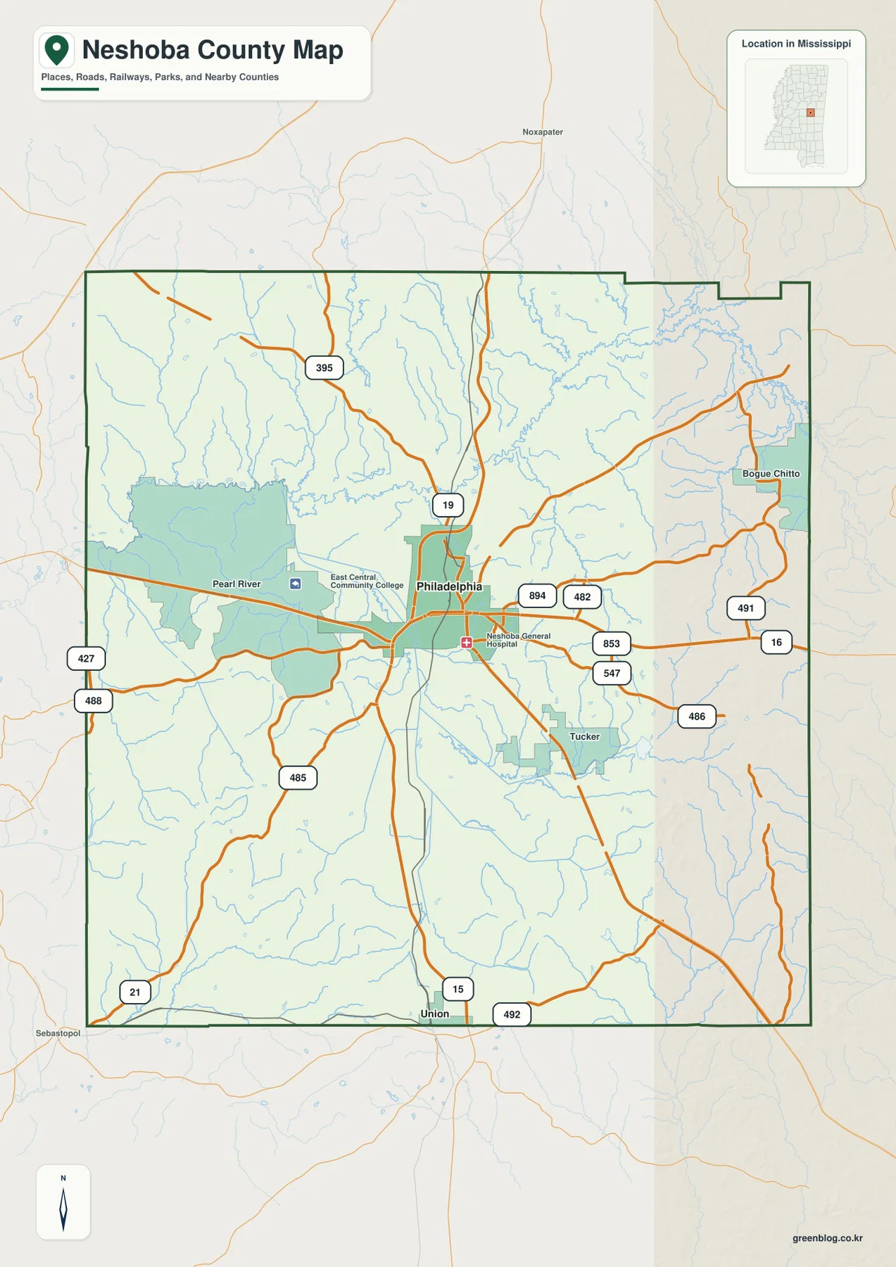
Community labels add another layer to the road map. Pearl River is shown west of Philadelphia, Tucker is southeast of the city, and Bogue Chitto appears in the northeastern part of the county. Those labels are useful for geographic orientation, especially when discussing communities associated with the Mississippi Band of Choctaw Indians, but the shaded areas on a general reference map should not be treated as precise legal or trust-land boundaries. The existing county material specifically warns that detailed tribal jurisdiction is simplified. For legal land status or jurisdiction, an official tribal or government boundary source is the appropriate reference.
The background beyond the county boundary is also helpful when the goal is regional orientation. Noxapater is labeled north of the county, while Sebastopol appears beyond the southwestern side. These outside references show that the map is not intended to make Neshoba County look isolated from the surrounding road system. For a close county-level reading, however, the dark boundary line is the key: features inside it belong to the Neshoba County map frame, while faint roads and places outside it are included mainly to show direction and continuity.
The city index highlights one dominant urban center
The city-focused map removes much of the road detail and ranks only Philadelphia as a major city. Its City Index displays Philadelphia with a value of 6,996. That figure should be read as the value used by this map’s city-ranking dataset rather than as a substitute for the county population or for every other population statistic on the page. The important visual point is that Philadelphia stands out as the primary urban center in the supplied city view, while smaller places and communities are better located on the general county map.
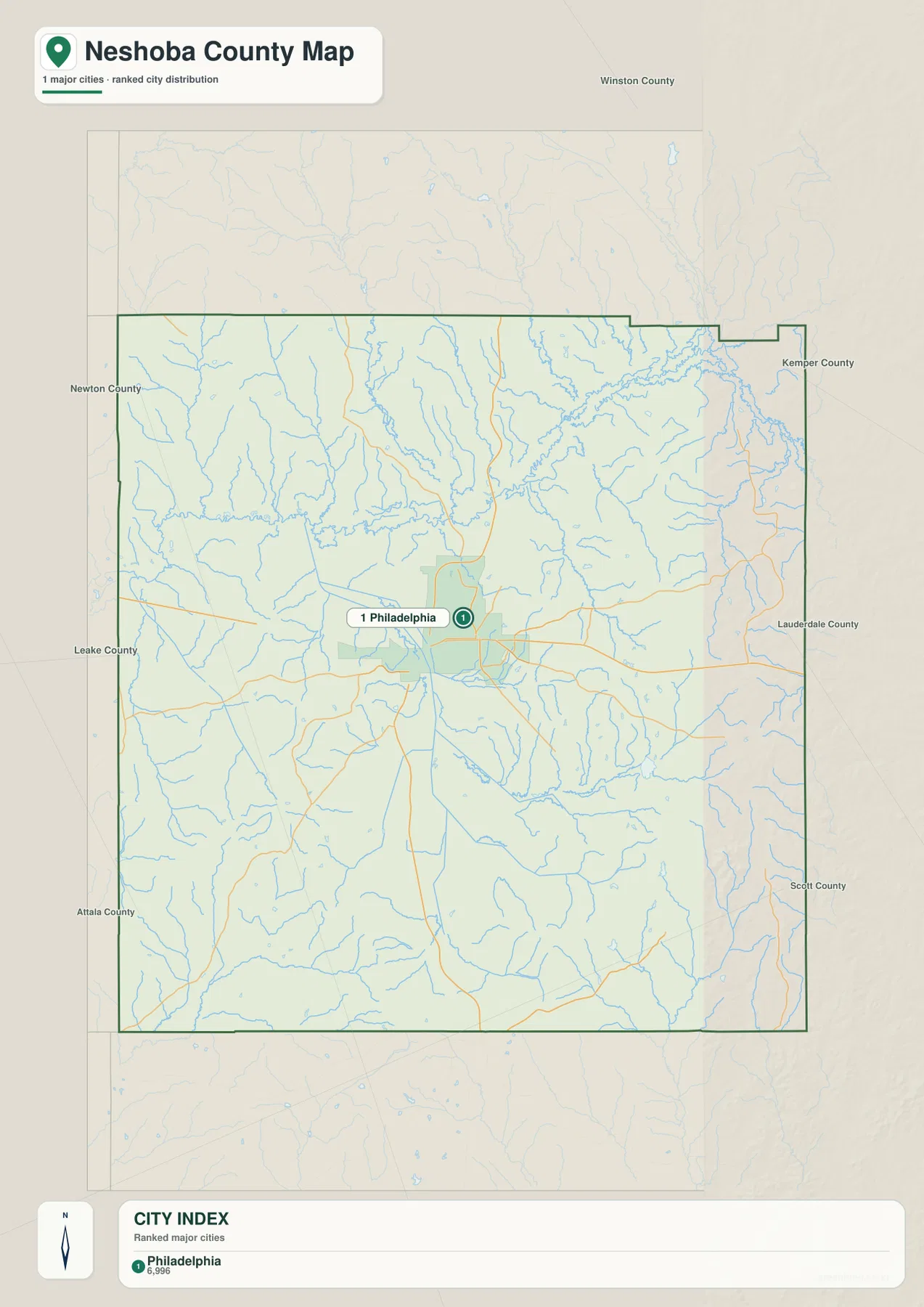
The surrounding county names make this stripped-down view especially useful. Winston, Kemper, Lauderdale, Scott, Attala, Leake, and Newton counties are all labeled around the frame, allowing readers to place Neshoba County within east-central Mississippi without first studying a statewide map. Because the city layer is deliberately simple, it works well as a second step after the road map: first identify Philadelphia and the main approach roads, then use the city view to see how the county fits among its neighbors.
Philadelphia’s central position also matches the broader context described in the existing material. It is the county seat and the place where courthouse, commercial, health-care, and local-service functions are concentrated. Nearby Choctaw communities have their own cultural, governmental, and economic importance, including major Mississippi Band of Choctaw Indians functions in the Pearl River area. A city ranking therefore should not be read as a ranking of cultural or governmental importance; it is simply one way of showing urban concentration.
Pearl River, creeks, and small lakes define the northern water map
The terrain-and-water map changes the emphasis completely. The Pearl River is one of the strongest labeled features across the northern part of the county, and a web of smaller streams reaches toward it from several directions. Bogue Chitto Creek is prominent in the northeast, Owl Creek runs along the eastern side, and Ocobla Creek extends southward from the larger northern drainage. Hurricane Creek is also labeled north of the river corridor. The fine blue lines between these named waterways show how many smaller tributaries are present even when they are not individually labeled.
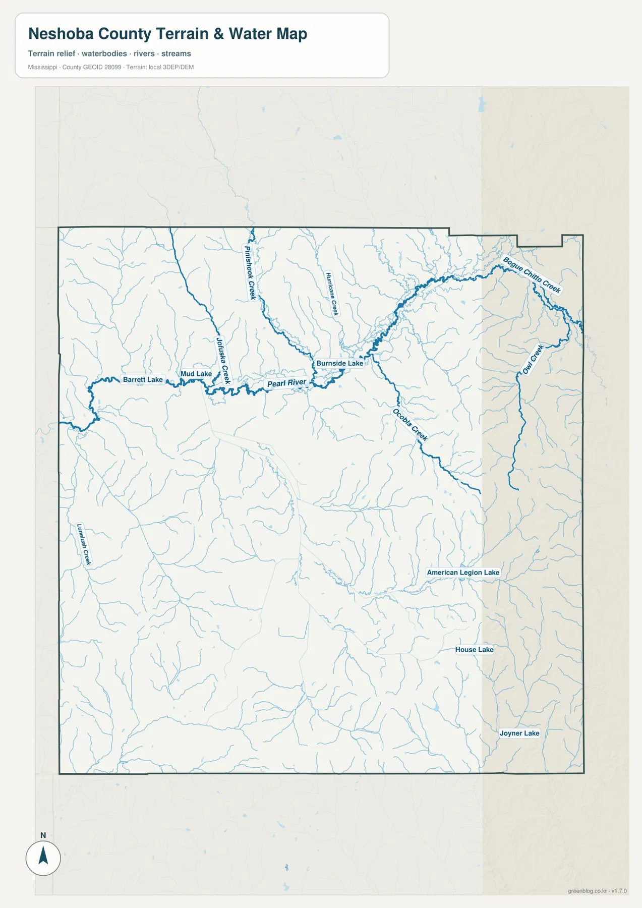
Several small lakes provide useful landmarks. Barrett Lake and Mud Lake are labeled near the western Pearl River section, while Burnside Lake appears farther east along the same broad northern water network. In the southeastern half of the county, American Legion Lake, House Lake, and Joyner Lake are marked as smaller isolated water bodies. No single lake dominates the county map. Instead, the visual character comes from many creeks, branches, and small lakes spread across a rolling landscape.
This map is best used as a water-reference layer, not as a flood-hazard or navigation chart. It does not provide flood zones, water depth, navigability, parcel ownership, or legal access. It is also important to distinguish the natural Pearl River from the Pearl River community name that appears in the general map context. When the question is about a stream, follow the blue water lines and water labels; when the question is about a community, return to the road and place-name map. That simple distinction prevents one of the most common sources of confusion on this page.
Higher ridges stand out along the eastern and southern terrain
The elevation map uses locally scaled terrain colors and shaded relief rather than road labels. Its legend shows an actual elevation range of roughly 109 to 217 meters, with a mean of 144 meters. Greens represent the lower parts of the local range, while yellow, tan, and brown mark progressively higher ground. This makes the broad contrast easy to see even before individual ridges and valleys are examined.
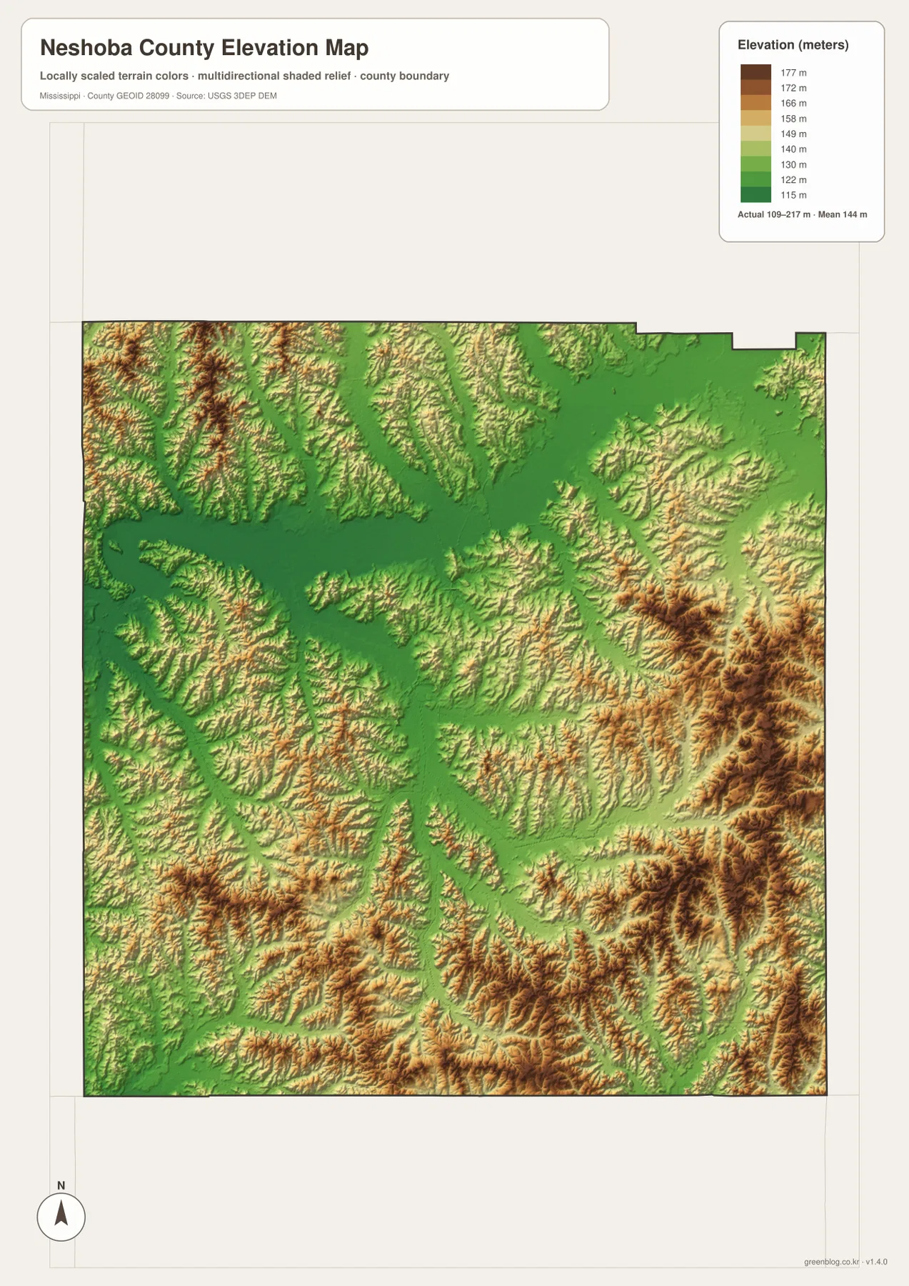
The strongest brown relief appears along the eastern side and becomes especially pronounced in the southeast. Elevated ridges also occur in the south and southwest, but the county is not a simple tilted surface that rises continuously in one direction. Lower green corridors cut between the hills, particularly through the central and northern areas. Those low corridors line up conceptually with the stream-rich landscape seen on the water map, where tributaries occupy the valleys between higher ground.
Comparing the two layers is more informative than reading the elevation colors alone. The water map shows where named streams and small tributaries concentrate, while the elevation map explains the broader terrain around those channels. This does not turn the elevation image into an engineering or survey product. The surface is generalized for regional viewing, so exact site elevations, construction grades, property drainage, or boundary decisions require dedicated source data. For a county overview, however, it clearly shows why Neshoba County has a rolling rather than flat appearance.
Population and area figures add scale to the map
The existing county material records a 2020 census population of 29,087 and a July 2025 population estimate of 28,732. These values come from different reference dates and should not be treated as two measurements taken under identical conditions. They are most useful here as context for the settlement pattern: the county contains one clearly dominant city in the supplied city index, yet a substantial share of residents live outside that one urban marker in smaller communities and rural areas.
| Item | Value used in the package |
|---|---|
| County | Neshoba County, Mississippi; FIPS 28099 |
| County seat | Philadelphia |
| 2020 census population | 29,087 |
| July 2025 population estimate | 28,732 |
| 2025 Gazetteer land area | 570.134 square miles |
| 2025 Gazetteer water area | 1.479 square miles |
| Elevation legend | about 109–217 m; mean 144 m |
The 2025 Gazetteer values list 570.134 square miles of land and 1.479 square miles of water. Combining the 2020 population with that land-area figure gives a countywide average of about 51 residents per square mile. It is only an average across the whole land area. It should not be read as evidence that Philadelphia neighborhoods, Choctaw communities, farms, wooded areas, and creek valleys all have similar settlement density.
The maps help explain why a single density value cannot describe the county very well. Roads and services are concentrated around Philadelphia, while the water and elevation layers show extensive terrain outside the urban center. The general map also identifies several community areas that are not represented as ranked cities. Reading the statistics alongside the maps therefore gives a more realistic picture than using the population table by itself.
Choose the map layer that matches the question
For basic orientation, begin with the county map. It is the best choice for explaining where Philadelphia and Union sit, which major numbered routes cross the county, and where community labels such as Pearl River, Tucker, and Bogue Chitto appear. If the task is to show Neshoba County among its neighbors with minimal visual clutter, the city map is cleaner because it emphasizes Philadelphia and the surrounding county names instead of filling the page with route numbers.
Use the water map when the subject is the Pearl River system, named creeks, or small lakes. It is much easier to follow Bogue Chitto Creek, Owl Creek, Ocobla Creek, and the small-lake labels there than on the general road view. Use the elevation map when the main point is the contrast between lower valleys and the higher eastern or southeastern hills. The four views describe the same county, but they answer different practical questions without forcing every label onto one crowded image.
For print use, the road map benefits from being kept close to its original size because it contains many route numbers and small labels. The water map also has numerous fine tributary lines, so aggressive downscaling can make the smallest channels harder to see. The elevation map depends on its color ramp to distinguish local height differences and is best kept in color. These are practical presentation considerations rather than restrictions on reuse; the main goal is to preserve the information each layer was designed to show.
What these maps should not be used to decide
The county and city maps are reference maps, not parcel or legal-boundary documents. They are useful for place relationships, road orientation, nearby counties, and the general position of labeled communities. They do not establish property ownership, municipal annexation details, tribal trust status, or jurisdiction. This matters in Neshoba County because several Choctaw community names appear near Philadelphia and because a shaded reference area can look more precise than it actually is.
The water layer has similar limits. A blue line confirms that a mapped stream is present in the reference dataset, but it does not show flood probability, seasonal flow, water quality, boat access, or safe crossing locations. The elevation layer is also generalized and should not be used for construction grades, site drainage, or survey work. Official hydrography, elevation, transportation, census, and tribal sources are linked below for readers who need more specialized information.
Finally, the city index should not be mistaken for a complete settlement list. Philadelphia is the only ranked major city in that particular map view, yet the general county map includes Union and multiple community labels. Choosing the correct layer is therefore part of reading the page accurately. A simple city map may be better for statewide orientation, while the richer county map is better for local roads and place names.
Frequently Asked Questions
Does Pearl River refer to both a river and a community in Neshoba County?
Yes. The water map uses Pearl River for the natural river system, while the general county context also uses Pearl River as a community name associated with the Mississippi Band of Choctaw Indians. Check the map type and the symbol or label around the name before assuming which meaning is intended.
Why is Philadelphia the only major city shown in the City Index?
The supplied city map uses a ranked major-city view and lists Philadelphia alone, with a displayed value of 6,996. That does not mean Union or other communities are absent from Neshoba County. Use the general county map when you need a broader set of local place names and roads.
Where does the elevation map show the strongest relief?
The eastern and southeastern parts of the county contain the broadest areas of tan and brown relief, indicating higher ground within the map’s local range. The legend spans about 109 to 217 meters with a mean of 144 meters. Central and northern green corridors are generally lower and often coincide with the valley-rich terrain visible on the water map.
Sources and reference data
These official sources provide supporting population, area, transportation, hydrography, elevation, and Choctaw information for the county context used on this page.
- U.S. Census Bureau QuickFacts for Neshoba County
- U.S. Census Bureau Gazetteer Files
- Mississippi Department of Transportation official highway map
- USGS National Hydrography
- USGS 3D Elevation Program
- Mississippi Band of Choctaw Indians
Map File Information
Download the map files associated with this page for reference, printing, and compatible visual projects.
- Included Files: 4 high-resolution A3 JPG maps described on this page
- File Type: JPG files in a ZIP archive
- Intended Use: Printing, education, presentations, and map-based projects
Related Maps
Green Map creates custom-edited map images using open geographic data sources such as geoBoundaries, Natural Earth, OpenStreetMap, and government open data. These maps are edited visual materials, not raw data files, and are provided for education, documents, presentations, and graphic reference.