Alcorn County occupies the northeastern corner of Mississippi, with Corinth serving as the main city and county seat near the Tennessee line. The maps on this page show much more than the county outline: US 45 and US 72 meet near Corinth, Farmington, Glen, Kossuth, and Rienzi provide useful reference points in different directions, and a dense network of creeks crosses the interior. A separate elevation view reveals lower central ground between higher ridges on the western and eastern sides. For printing, classroom work, presentations, or local reference, a downloadable ZIP contains four high-resolution A3-format JPG maps matching the subjects shown here.
The county is compact enough that its main places are easy to compare on one page, yet the terrain is more varied than a simple road map suggests. Corinth sits close to the northern part of the county, major highways spread out from the city, and small waterways divide the surrounding countryside into many shallow valleys. Looking at the general map first and then moving to the city, water, and elevation views makes it easier to understand how settlement, transportation, and terrain fit together without turning the page into a technical GIS report.
Table of Contents
Corinth gives Alcorn County an easy starting point
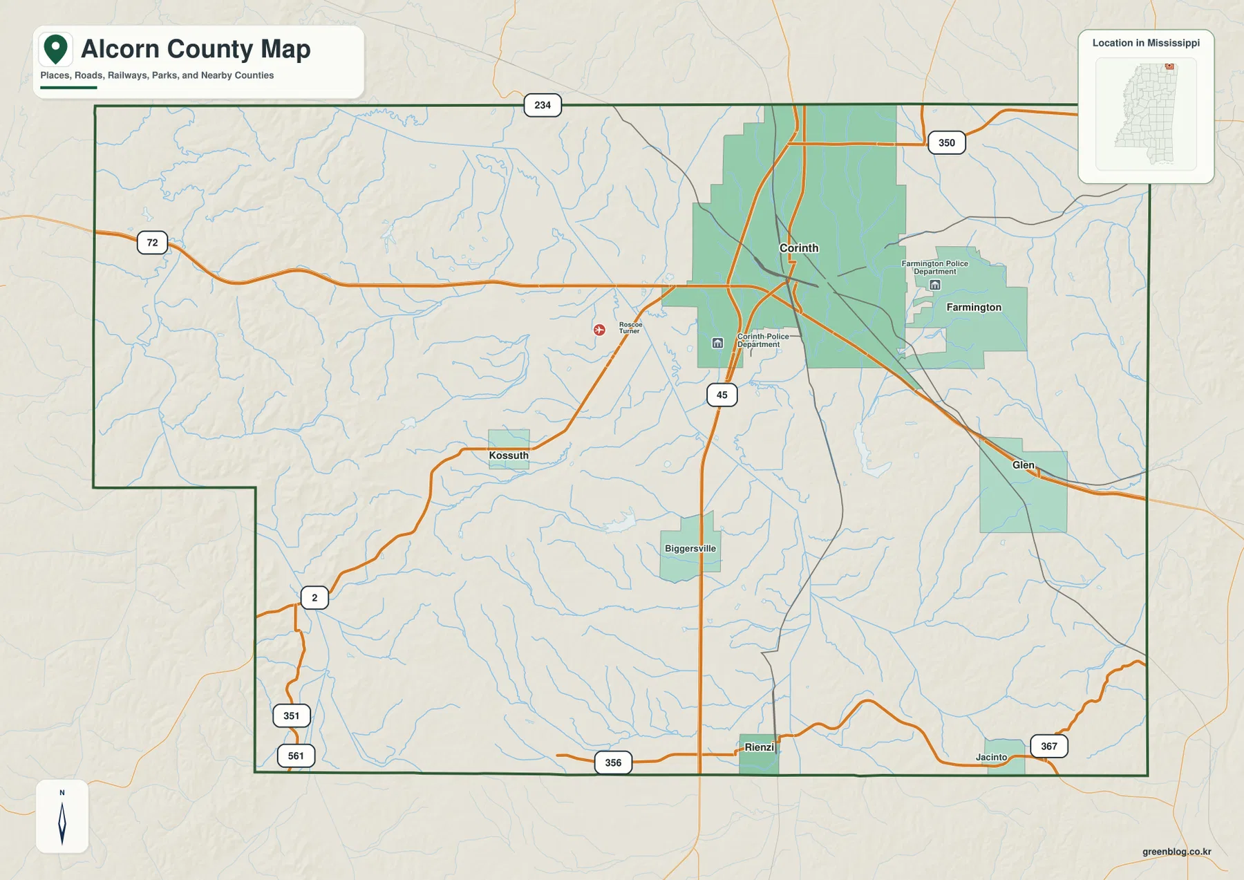
For a first look at Alcorn County, Corinth is the most practical place to begin. It appears in the northern part of the county, slightly east of center, where highways and rail lines converge. Farmington lies just to the east of Corinth, while Glen is farther southeast. Kossuth provides a western reference and Rienzi marks the southern part of the county. Because those places are spread in different directions, they quickly establish the county’s scale and make the irregular outline easier to follow.
The surrounding counties add another layer of orientation. Tippah County is shown to the west, Prentiss County to the southwest, and Tishomingo County to the east. The northern boundary is the Tennessee state line, placing Corinth much closer to an interstate border than many Mississippi county seats. The southwestern edge also has a noticeable step in the boundary rather than forming a simple rectangle. These details make the general map useful when a reader needs to explain where Alcorn County sits before discussing individual roads or towns.
US 45 and US 72 organize the main road pattern
The road network becomes much easier to follow once the two U.S. highways are identified. US 45 runs generally north–south through Corinth and continues toward the southern county line. US 72 crosses the northern half of the county from west to east and passes through the Corinth area before continuing beyond the county. Their meeting near the county’s largest city creates a clear transportation reference that is visible even before the smaller state routes are considered.
Other roads help connect the outer parts of the county. MS 2 approaches Kossuth from the southwest, Route 356 is labeled along the southern edge, and Route 367 appears toward the southeast. The purpose of the map is not to replace a turn-by-turn road atlas, but these routes are enough to show how the western and southern communities connect back toward Corinth. They also make it clear that the county’s road pattern is not a uniform grid; roads bend around valleys and follow the rolling terrain.
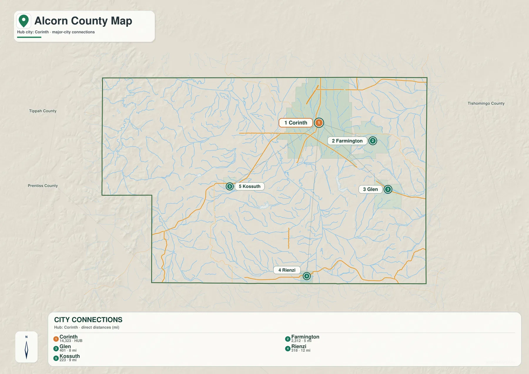
The city map removes much of the extra detail and emphasizes the relationship among five named places. Farmington is about 5 miles from Corinth by the direct-distance measure shown on the map, Glen about 8 miles, Kossuth about 9 miles, and Rienzi about 12 miles. The exact road distance will be longer in many cases, but the direct measurements are useful for comparing location. Farmington sits east of the hub, Glen southeast, Kossuth west, and Rienzi south, giving the reader four different directional anchors around Corinth.
Rail lines on the general map also explain why Corinth has long stood out. The city grew around a railroad junction in the nineteenth century and became strategically important during the Civil War. Modern roads should not be treated as a direct copy of that historic rail pattern, but the map still shows the same broad geographic advantage: major routes come together near Corinth instead of being spread evenly through the county. That combination makes the map especially useful for local history pages that need present-day geographic context.
Creeks and small lakes divide the interior into many valleys
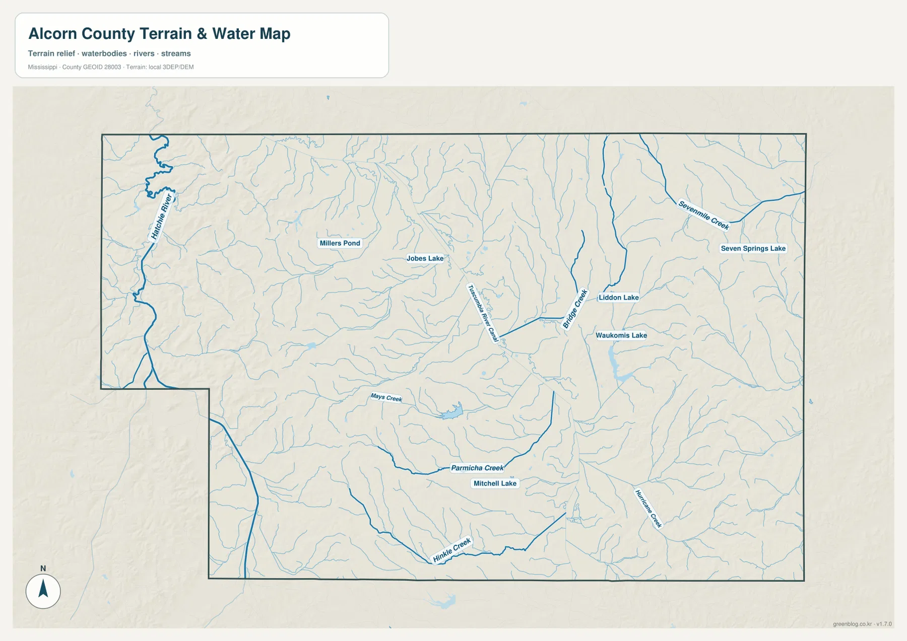
The water map changes the emphasis from roads to the county’s dense drainage network. Rather than one large lake dominating the landscape, many small streams branch through the interior. The Hatchie River is labeled along the western side, Sevenmile Creek appears in the northeast, and Bridge Creek runs through the east-central area. Farther south, Parmichie Creek and Hinkle Creek provide longer named references. Numerous thinner tributaries fill the spaces between them, showing why the countryside contains so many small valleys and ridges.
Several named lakes and ponds are also visible. Millers Pond and Jobes Lake are in the northern half of the county, while Seven Springs Lake, Liddon Lake, and Waukomis Lake appear farther east. Mitchell Lake is marked in the southern half near Parmichie Creek. These water bodies are useful landmarks, but the map does not provide depth, shoreline access, fishing rules, or water-quality information. Readers planning recreation should treat this page as a location reference and use the appropriate managing agency for current conditions or access rules.
The strongest benefit of the water map comes from comparing it with the terrain view. Many creeks occupy the lower spaces between ridges, so the branching blue lines correspond closely with the valleys visible in shaded relief. That relationship is easy to see in the center and eastern part of the county, where several waterways run through long, narrow low areas. The map is not a flood-hazard product, however, and it should not be used to determine whether a property or road is inside a floodplain.
Lower central ground sits between higher western and eastern ridges
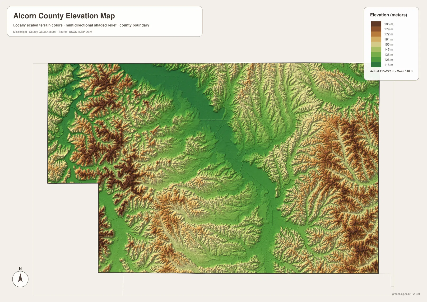
The elevation map shows an actual county range of about 115 to 222 meters, with a mean elevation near 148 meters. Darker greens identify lower ground and yellows to browns mark higher areas. A broad lower corridor runs through much of the central part of the county, while the western and eastern margins contain more closely spaced ridges and higher terrain. The result is a landscape of rolling uplands rather than a flat plain or a single continuous mountain ridge.
The western side contains repeated short ridges, especially toward the northwest and southwest. Similar dissected terrain appears in the east and southeast, where narrow valleys cut between higher slopes. In the middle of the county, lower and gentler ground forms a noticeable contrast. This pattern helps explain why the water map contains so many branching streams: water follows the lower valleys between the ridges rather than crossing the highest ground.
The colors are scaled to make differences inside Alcorn County easy to see, so they should not be compared directly with the color palette on an elevation map for another county. The numeric legend is the better guide when an exact range matters. This map is suitable for general geographic explanation, classroom use, and broad terrain comparison, but it is not a substitute for survey-grade elevation, engineering measurements, or trail-level slope information.
Population and area add useful scale to the map
Alcorn County recorded 34,740 residents in the 2020 census, while the July 2025 population estimate is 34,569. Those figures come from different reference dates and should not be read as if they were two measurements taken under identical conditions. The maps also make an important point that a countywide population number cannot show by itself: people are not spread evenly across the landscape. Corinth is the dominant urban area, while smaller communities and rural land occupy the surrounding valleys and uplands.
- County: Alcorn County, Mississippi / FIPS 28003
- County seat: Corinth
- 2020 census population: 34,740
- July 2025 population estimate: 34,569
- 2025 Gazetteer area: 400.047 square miles of land and 1.314 square miles of water
- 2020 population divided by land area: about 86.8 residents per square mile
With roughly 400 square miles of land, the county is small enough for Corinth and the other named communities to fit comfortably on one regional map, yet there is still substantial rural space between them. The average figure of about 86.8 residents per square mile is a mathematical countywide value, not a description of every neighborhood or farm. Pairing the statistics with the city map gives a more realistic sense of settlement because the concentration around Corinth is visible instead of being hidden inside one average.
Choose the map according to the question you need to answer
The general county map is the best starting point when several kinds of information need to appear together. It combines the county outline with Corinth, smaller communities, important highways, rail lines, waterways, and neighboring counties. For a presentation about where Alcorn County is located or how Corinth connects to the rest of northeastern Mississippi, this is usually the most efficient single image.
The city map is cleaner when the main goal is to compare Corinth with Farmington, Glen, Kossuth, and Rienzi. The water map is more useful for finding named creeks, lakes, ponds, and the Hatchie River. The elevation map should be used when the explanation depends on the contrast between the lower central valleys and the higher rolling ground along the sides of the county. Using the specialized view avoids crowding one map with information that belongs to a different question.
- General county map: location, highways, railways, settlements, and neighboring counties
- City map: directions and direct-distance comparison from Corinth to four nearby communities
- Water map: named rivers, creeks, lakes, ponds, and the dense drainage network
- Elevation map: the 115–222 m terrain range and the contrast between valleys and higher ridges
The in-page WebP images are convenient for quick viewing, while the JPG files in the ZIP are better when the map needs to be printed or inserted at a larger size. The archive contains only the four map types described on this page; it does not include parcel boundaries, land-cover classes, flood zones, or other specialized datasets. For decisions that require legal, engineering, emergency-management, or property-level accuracy, use the relevant official source rather than treating these overview maps as a substitute.
Frequently Asked Questions
Where is Corinth within Alcorn County?
Corinth is in the northern part of the county, slightly east of center, near the meeting of US 45 and US 72. Farmington lies to the east, Kossuth to the west, Glen to the southeast, and Rienzi to the south, so Corinth works well as the main reference point for the rest of the map.
Which map is best for finding Alcorn County creeks and lakes?
Use the water map. It labels features such as the Hatchie River, Sevenmile Creek, Bridge Creek, Parmichie Creek, Liddon Lake, Waukomis Lake, Seven Springs Lake, and Mitchell Lake while also showing the many smaller tributaries that cross the county.
Is Alcorn County mostly flat?
No. The supplied elevation map shows an actual range of roughly 115 to 222 meters. Lower ground is most noticeable through the central part of the county, while higher rolling ridges are more common along the western and eastern sides.
Map File Information
The WebP images on the page are optimized for viewing. The ZIP below contains the matching high-resolution JPG files for larger displays, printing, and reuse.
- Printable Size: 3638 × 2572 px for each map
- File Type: ZIP containing 4 JPG files
Related Maps
Sources and references
Population and area figures come from U.S. Census Bureau resources. The road, county-history, hydrography, and elevation references below provide additional authoritative context for the geographic features discussed on this page.
- U.S. Census Bureau QuickFacts – Alcorn County
- U.S. Census Bureau Gazetteer Files
- Mississippi Encyclopedia – Alcorn County
- Mississippi Department of Transportation official highway map
- USGS National Hydrography
- USGS 3D Elevation Program
Green Map creates custom-edited map images using open geographic data sources such as geoBoundaries, Natural Earth, OpenStreetMap, and government open data. These maps are edited visual materials, not raw data files, and are provided for education, documents, presentations, and graphic reference.