Adams County sits in southwest Mississippi with Natchez close to the Mississippi River on the county’s western side. Its outline is unusually easy to recognize because the river boundary bends repeatedly, while the eastern side reaches into higher, more dissected ground. The maps on this page let you compare that shape with the county’s main roads, the concentration of settlement around Natchez, named creeks and lakes, and the sharp elevation contrast between the river edge and the interior. A downloadable ZIP with four high-resolution A3-format JPG maps is also provided below for printing or reuse.
The most useful way to approach Adams County is to think of it as a river county with two very different landscapes. Low ground follows the Mississippi and its broad bends on the west. Moving east, the surface becomes progressively rougher, with narrow valleys and ridges packed much more tightly together. Natchez occupies the transition near the river rather than the geometric center of the county, and the highway pattern radiating from the city reinforces its role as the principal local reference point.
Table of Contents
A county boundary shaped by the Mississippi River
The western edge of Adams County is not a straight surveyed line. It follows large river bends that push the county boundary outward and then back toward the interior, producing several long lobes and narrow connections. The southwestern portion is especially distinctive, with an elongated bend that reaches well beyond the more regular eastern side. Those curves matter when reading the map because places that look far west of Natchez are still part of the same county outline. By comparison, much of the eastern boundary is straighter, although the southern and northeastern edges remain irregular where the county meets neighboring jurisdictions and natural features.
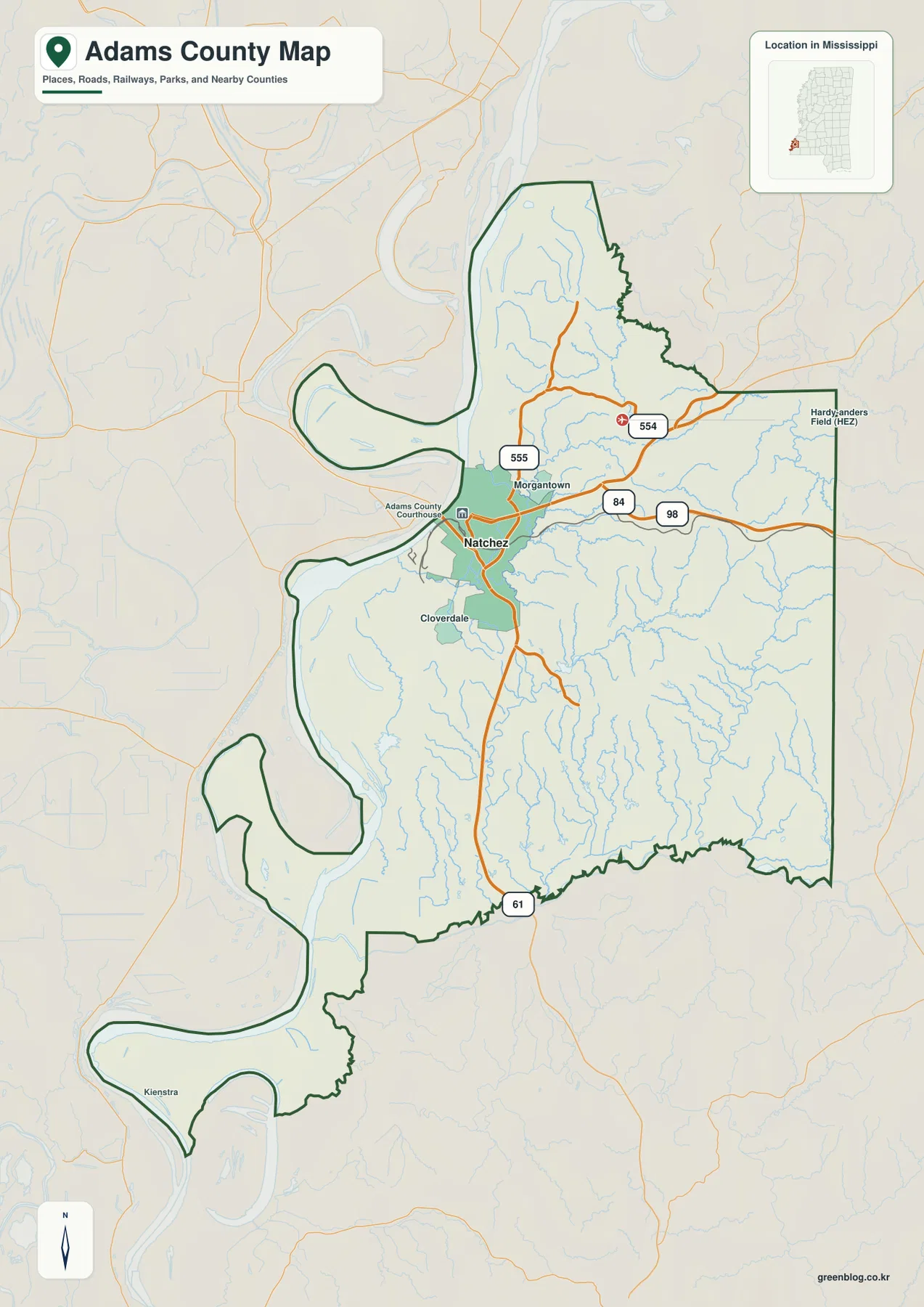
Natchez is the dominant place name near the west-central edge. Morgantown appears just to the north, Cloverdale lies south of Natchez, and Kienstra is labeled farther down in the southwestern river-bend area. Hardy-Anders Field (HEZ) is marked near the northeastern side. These labels make the county easier to orient than a blank boundary map because they provide recognizable points across several parts of the outline. The map is best used for general location, not for parcel ownership, precise legal boundaries, or turn-by-turn navigation.
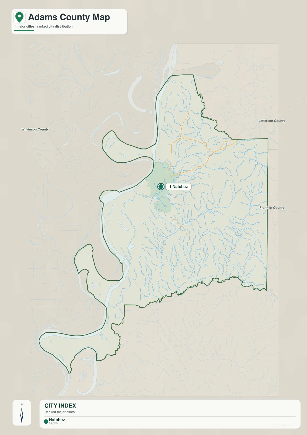
The city-oriented map also places Jefferson County to the northeast, Franklin County to the east, and Wilkinson County to the west of the displayed county area. Across the Mississippi River, the broader regional context continues into Louisiana. That river crossing is important to the identity of Natchez, but the county itself remains on the Mississippi side of the state line. Keeping the river and neighboring counties visible prevents a common map-reading mistake: assuming that every patch of land inside a river bend belongs to the same state or county.
Natchez stands out as the county’s main urban reference
The city index is intentionally simple. Natchez is the one major city listed, with a displayed population of 14,192, and no second city competes with it visually on the county map. That does not mean the remainder of Adams County is empty. It means the settlement pattern is strongly concentrated around one recognizable urban center while much of the inland county is represented by smaller communities, roads, wooded terrain, and drainage features rather than large city labels. For anyone trying to understand where local activity is focused, that contrast is more informative than a long list of minor place names.
The road network explains why Natchez functions as such a useful anchor. US 61 passes north and south through the city and continues toward the county’s southern boundary. US 84 and US 98 head east from the Natchez area and provide a clear visual route into the interior. North of the city, Mississippi 554 crosses east-west, while 555 links the Morgantown area with roads approaching Natchez from the north. The map does not replace current driving directions, but it does show how the major routes converge near the river city before separating toward other parts of southwest Mississippi.
That pattern also explains why Natchez appears off-center on the page. A county seat does not have to sit in the middle of its boundary. Here, the river edge, the historic concentration of settlement, and the highway network all pull the visual focus westward. If you are preparing a regional presentation, a school handout, or a simple locator image, tracing US 61 first and then following US 84 and US 98 eastward is an efficient way to introduce the county without overwhelming the reader with smaller roads.
Creeks, lakes, and the river connect the interior to the west
The terrain-and-water map reveals far more blue linework than the general reference map. The Mississippi River dominates the western side, but Adams County also contains a dense network of smaller drainage channels. St. Catherine Creek is labeled in the north-central interior, Fair Creek and White’s Creek appear farther south, Smith Creek runs near the southeastern part of the county, and Sandy Creek is shown along the eastern side. These named streams sit within many smaller tributaries, making the interior look finely divided compared with the broad river corridor.
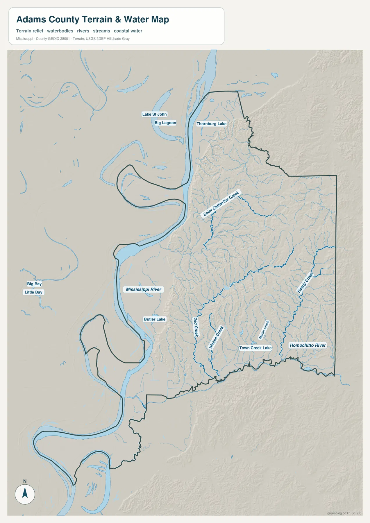
Several named water bodies help break up the larger pattern. Lake St John and Big Lagoon are visible near the northern river area, Thornburg Lake is labeled near the northern part of the county, Butler Lake lies nearer the west-central river corridor, and Town Creek Lake appears farther inland toward the south. The southern edge is also associated with the Homochitto River, a much larger watercourse than the small creeks farther north. Taken together, the labels show that Adams County is not simply a strip beside one major river; its interior is crossed by numerous smaller channels that connect higher ground with lower areas to the west and south.
This water map should be read as a geographic reference rather than a flood-hazard product. It does not show expected water depth, flood frequency, levee performance, navigability, or property-level risk. For those questions, a dedicated official flood or water-management source is necessary. Its value here is different: it lets a reader see where named streams are located, how tightly drainage lines fill the eastern terrain, and how the Mississippi River frames the western side of the county.
Low river ground gives way to a much higher eastern interior
The elevation map provides the clearest visual explanation for the county’s landscape. Dark green dominates the river bends and much of the western low ground. Toward the center, the surface changes through lighter greens and yellows, and the eastern half contains broad areas of tan and brown where the terrain is higher. The relief shading also shows many narrow valleys cut into the eastern uplands. The map legend gives an actual elevation span of about 11 to 134 meters and a mean elevation of roughly 54 meters, so the contrast is not merely a color effect.
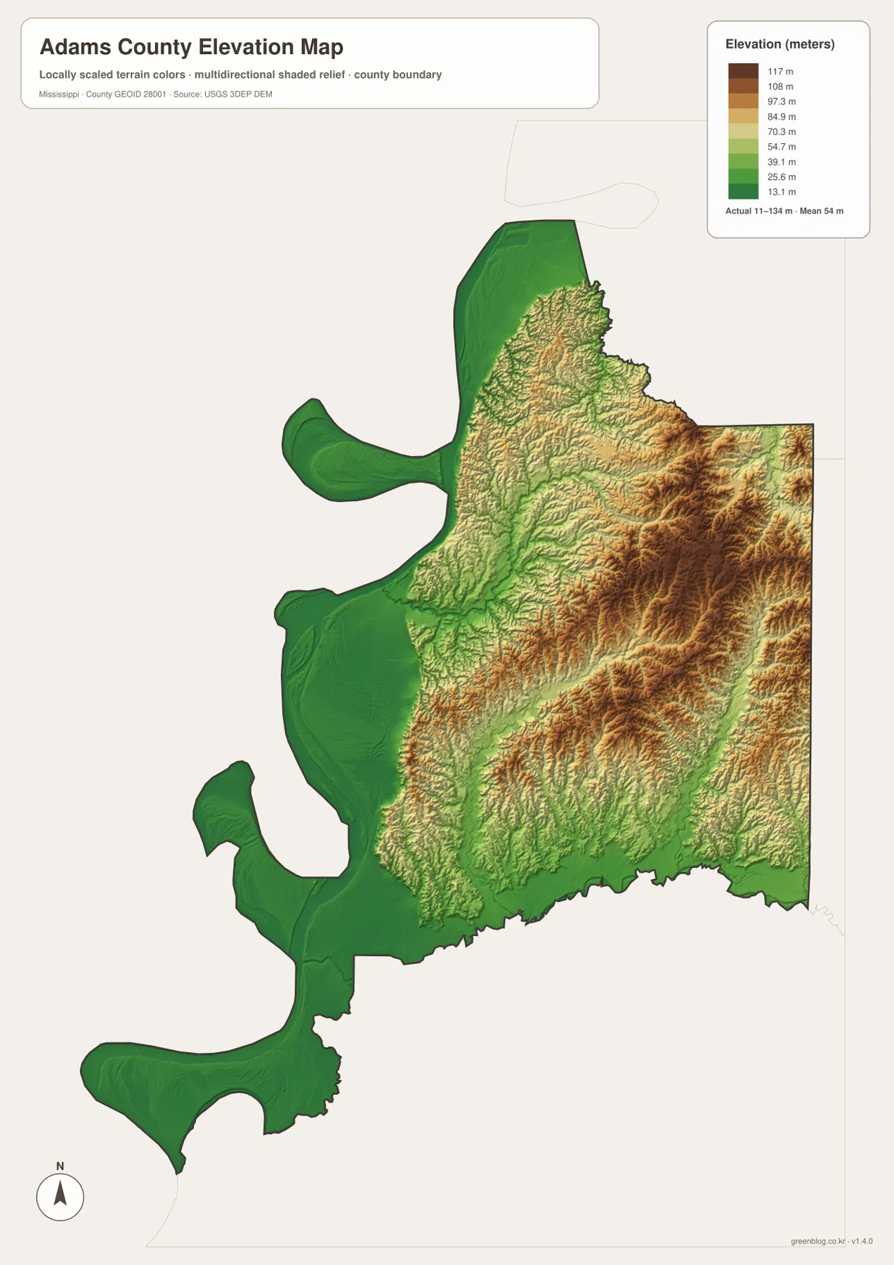
Natchez sits near the river but is associated with bluff country rather than the flattest part of the floodplain. The broader map makes that relationship easier to understand: the river corridor is low, yet higher land approaches close to the city before becoming even more pronounced farther east. This is one reason a simple road map can hide an important part of the local geography. Two locations may look close in straight-line distance while the terrain between them changes quickly through slopes, ridges, and creek valleys.
Comparing the water and elevation maps is especially useful in eastern Adams County. The higher brown and tan terrain is cut by many branching blue drainage lines, while the western green areas are broader and smoother. This combination gives the county a strong east-to-west transition from dissected upland to lower river country. The elevation surface is generalized for county-scale viewing, however, and should not be treated as survey-grade information for construction, engineering, or a specific property.
Population and area make more sense beside the maps
- County seat: Natchez
- FIPS code: 28001
- 2020 census population: 29,538
- July 2025 population estimate: 30,061
- 2025 Gazetteer area: 462.344 square miles of land and 25.202 square miles of water
- Density using the 2020 population and land area: about 63.9 residents per square mile
These values do not all describe the same date. The 2020 figure is a decennial census count, while the July 2025 number is a later population estimate. The Gazetteer separates land from water, which is especially useful in a county where a major river and several water bodies occupy a visible part of the mapped area. The density figure is an average across the entire land area. It should not be interpreted as a uniform settlement pattern, because the city map clearly shows a much stronger concentration around Natchez than across the large eastern and southern sections of the county.
Choosing the map that fits the question
For a quick county overview, start with the general map because it combines the boundary, Natchez, several local place names, and the major highways. Use the city map when the main question is where the county’s dominant urban center sits in relation to the surrounding area. The terrain-and-water map is better when you need named creeks, lakes, and the Mississippi River to be prominent. The elevation map is the most useful choice for explaining why the eastern interior looks more rugged and why the river side appears much lower.
Those differences also matter when the maps are reused in documents. A history or travel handout centered on Natchez will usually benefit from the general map first, with the water map added if the Mississippi River is part of the story. A physical-geography lesson can pair the water and elevation maps to show how tributaries cut through higher ground before reaching lower areas. If the goal is actual travel planning, flood assessment, engineering, or property research, use these maps only for orientation and consult the current specialized source for the decision itself.
Frequently Asked Questions
Why is Natchez so close to the western edge of Adams County?
Natchez developed beside the Mississippi River and the bluff country above it, so the county seat is naturally positioned near the western side rather than near the center of the county outline. Adams County extends much farther east into higher terrain. The road map also shows that US 61, US 84, and US 98 converge around Natchez, reinforcing the city’s importance even though it is off-center geographically.
What becomes clearer when the water and elevation maps are compared?
The comparison shows a strong relationship between the rougher eastern uplands and the dense network of small creeks. Branching drainage lines cut through the higher terrain, while the western side becomes lower and broader near the Mississippi River. This is useful for understanding the county’s physical shape, but the maps are not substitutes for flood modeling or surveyed elevation at a specific location.
What is included in the downloadable map ZIP?
The ZIP contains four high-resolution JPG files matching the maps shown on the page: the county reference map, the Natchez-focused city map, the terrain-and-water map, and the elevation map. The JPG versions are intended for users who need larger files for printing, presentations, or document layout rather than the smaller WebP previews used in the article.
Map File Information
The page previews use WebP images for faster viewing. The download ZIP contains the matching high-resolution JPG originals for the Adams County reference map, city map, terrain-and-water map, and elevation map, making it the better choice for printing or placing the maps in another document.
- Included Files: county map, city map, terrain-and-water map, elevation map
- File Type: ZIP containing four JPG files
Related Maps
Sources and references
Population and area values were checked against U.S. Census Bureau resources, while the supplied maps and Mississippi reference sources were used for local place, road, river, and county context.
- U.S. Census Bureau QuickFacts – Adams County, Mississippi
- U.S. Census Bureau Gazetteer Files
- Mississippi Encyclopedia – Adams County
- Mississippi Department of Transportation official highway map
Green Map creates custom-edited map images using open geographic data sources such as geoBoundaries, Natural Earth, OpenStreetMap, and government open data. These maps are edited visual materials, not raw data files, and are provided for education, documents, presentations, and graphic reference.