This Sumter County South Carolina Map set is organized around the details that are easiest to verify in the supplied maps: the road network centered on Sumter, the relative positions of Mayesville and Pinewood, and the waterways that run from the Little River-Lake Marion side of the county to the Pocotaligo and Black rivers farther east. The page uses WebP previews for quick viewing, and the matching high-resolution A3 JPG files are available together in a ZIP download for printing, reports, or classroom materials.
The general county map is the most detailed view for roads and community labels. The city-connection map removes much of that detail and uses Sumter as the hub for Mayesville and Pinewood. The terrain-and-water map changes the emphasis again, making rivers, creeks, lakes, ponds, and low-relief terrain easier to follow. Taken together, the three views explain the county more clearly than the older outline-only presentation because the central urban area, the southern reach toward Pinewood, and the long eastern section are visibly different.
Table of Contents
Sumter is the road hub between US 76, US 378, Route 15, and US 521
The county map makes Sumter the obvious starting point. Routes 76 and 378 enter the central area from the west near Stateburg, while 441 and 15 approach from the north and northwest through the Dalzell side of the county. South of Sumter, 521 continues toward the Pinewood area. East Sumter sits on the opposite side of the central road network, where routes 53 and 95 help organize the transition into the long eastern section.
Farther east, 527 connects the Mayesville area with roads running southeast across the county. Routes 341 and 403 are visible near the northeastern end, and Shiloh provides a useful place label inside that extension. The southwest has a different pattern: Wedgefield and Cane Savannah lie below the 76-378 corridor, while Pinewood is shown near 120 and 261. These route labels make it possible to move from the dense Sumter center into the outer parts of the county without relying on a single county outline.
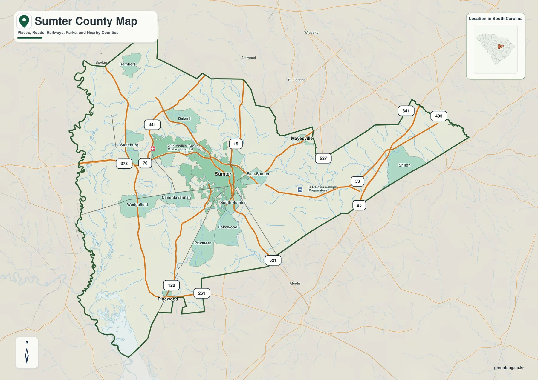
The map also labels Rembert, Boykin, Dalzell, Stateburg, East Sumter, South Sumter, Lakewood, Privateer, and other communities or local place areas. They are useful because they show how the Sumter urban center gives way to more widely spaced places in every direction. Rembert and Boykin are northwest of Sumter, Stateburg and Wedgefield are to the west, and Lakewood and Privateer lie on the southern side before the county reaches Pinewood. East of Sumter, the labeled roads and streams spread over a much larger open area.
Mayesville lies northeast of the hub while Pinewood anchors the south
The city-connection map is deliberately simple. Sumter is the hub, Mayesville is marked northeast of it, and Pinewood appears far to the south. The legend gives a direct distance of about 9 miles from Sumter to Mayesville and about 14 miles from Sumter to Pinewood. These are straight-line distances, not driving distances, so they should be used for orientation rather than trip planning.
The surrounding county names provide useful regional context. Lee and Kershaw counties are shown across the north, Florence and Williamsburg are on the eastern side, Clarendon is to the west, and Richland and Calhoun appear along the western-southwestern side. This makes the city map useful for two different questions at once: where Mayesville and Pinewood sit relative to Sumter, and where Sumter County sits among its neighboring counties.
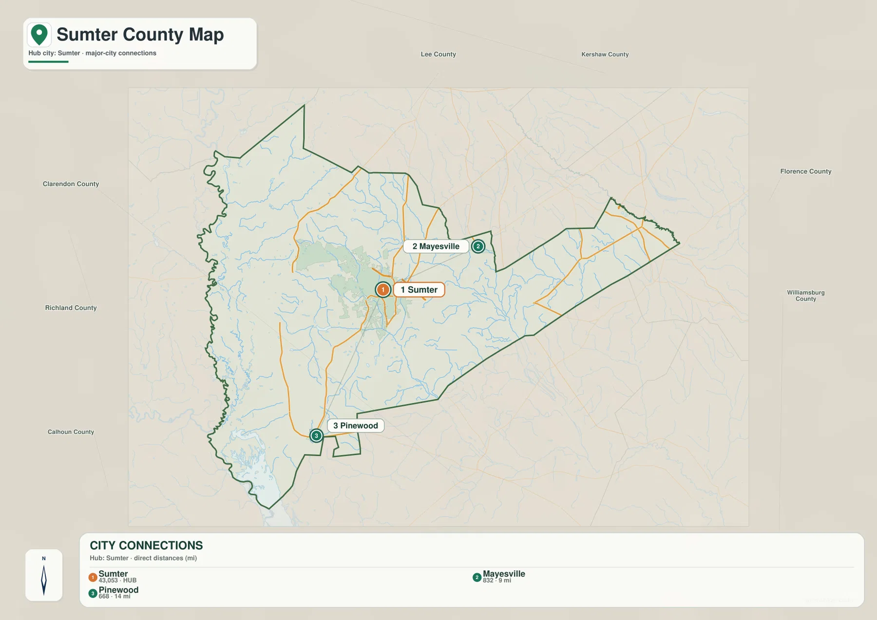
The city map works best as the first step when the question is simply where a place lies. After identifying Mayesville northeast of Sumter, the county map can add Route 527 and nearby roads. After locating Pinewood to the south, the county map adds 521, 120, and 261. Separating those tasks keeps the city view readable and prevents a straight-line distance label from being mistaken for a road itinerary.
Little River and Lake Marion define the southwestern water landscape
The terrain-and-water map is most visually dramatic in the southwest. Little River follows the western side of the county and continues toward the broad water of Lake Marion at the southern edge. On the general map this area competes with road and place labels, but the water map makes the branching channels and the large lake boundary much easier to see.
Beech Creek is also labeled in the western interior, and many small tributaries feed the larger waterways. The density of blue stream lines gives the southwest a very different appearance from the Sumter road center. Lake Marion is the largest named water reference on the supplied map, so it is especially useful for locating the county’s southern end and for understanding the area southwest of Pinewood.
Pocotaligo River and Black River organize the center and east
Pocotaligo River is labeled as a strong south-flowing channel through the south-central part of the county. Numerous smaller streams join or run near it, making it an important reference when looking east and south of Sumter. Farther east, Black River forms another clear north-south water line. The space between the Pocotaligo and Black rivers contains many smaller tributaries, so the eastern half is not a blank extension even though it has fewer major place labels than central Sumter.
Rocky Bluff Swamp is labeled near the Black River side, adding a wetland feature that looks different from a conventional river channel. For a quick overview, the major sequence is easy to remember: Little River and Lake Marion in the southwest, Pocotaligo River through the south-central area, and Black River farther east. Smaller creeks, ponds, and lakes can then be added when a more detailed local reference is needed.
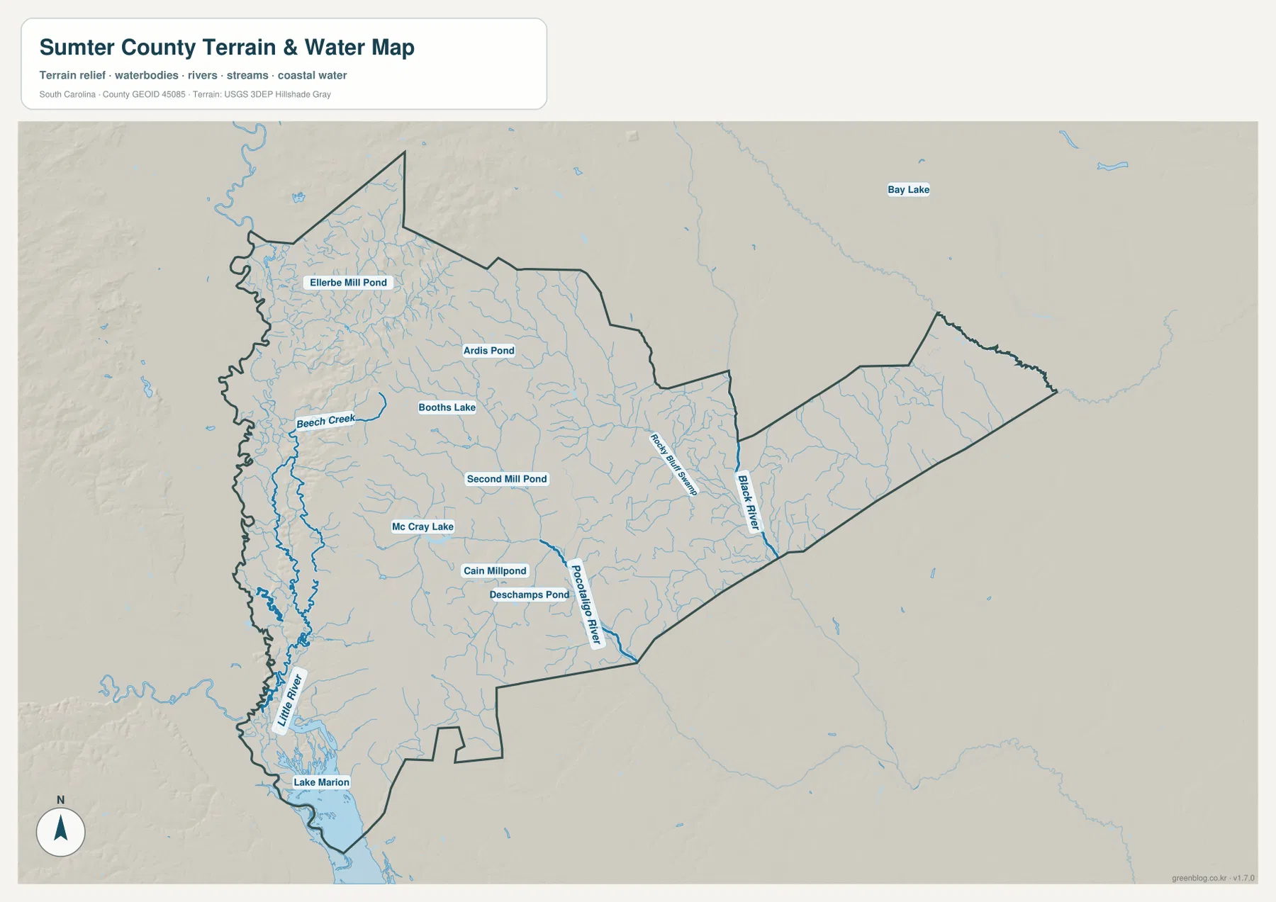
Named ponds and small lakes fill in the interior between the larger rivers
The water map includes several smaller named water bodies that help with local orientation. Ellerbe Mill Pond is shown in the northwest, with Ardis Pond and Booths Lake farther southeast. Second Mill Pond and Mc Cray Lake appear closer to the middle of the county, while Cain Millpond and Deschamps Pond are farther south. These labels provide useful internal landmarks in areas where the road map may have fewer large town names.
The shaded terrain is comparatively subdued rather than mountainous. Its main value is to give the stream lines and low-relief surface some visual depth, not to provide precise elevation readings. The western side contains a dense network of small tributaries, while the east becomes easier to recognize from the Black River corridor. Exact spot elevations would require dedicated elevation data rather than this shaded-relief preview.
Start with the hub, add the roads, then switch to water when needed
A practical way to use the set is to begin with the city-connection map if the question is about Mayesville or Pinewood. Once the broad direction is clear, move to the general map for routes 527, 15, 521, 120, 261, 76, and 378. For the Sumter urban area itself, the general map is often the fastest choice because so many roads and nearby place labels converge around the center.
When the question involves rivers, lakes, or terrain, finish with the water map. The southwest is anchored by Little River and Lake Marion, the south-central area by Pocotaligo River, and the east by Black River. The WebP images on the page are intended for quick screen viewing; for printing or larger layouts, use the A3 JPG originals in the ZIP download below.
These maps are general geographic references rather than live-navigation, legal-boundary, parcel, flood-risk, or survey products. The city-connection distances are straight-line measurements, road conditions can change, and the terrain shading does not provide exact spot elevations. Use current authoritative sources whenever a decision depends on those details.
Frequently Asked Questions
Are the Mayesville and Pinewood distances driving distances?
No. The city-connection map shows Mayesville at about 9 miles and Pinewood at about 14 miles from the Sumter hub, but the legend identifies those values as direct distances. Actual road distance and travel time will depend on the route used.
Which map is best for Lake Marion and Black River?
Use the terrain-and-water map. Lake Marion is shown along the county’s southwestern end, while Black River is labeled in the eastern part. Little River, Pocotaligo River, Beech Creek, Rocky Bluff Swamp, and several ponds are visible there as well.
What files are included in the downloadable ZIP?
The ZIP contains three high-resolution A3 JPG files corresponding to the previews on the page: the general county map, the city-connection map, and the terrain-and-water map. The WebP versions in the article are lighter files for browser viewing.
Map File Information
Download the Sumter County road map, city-connection map, and terrain-and-water map together as high-resolution A3 JPG files.
- Included Files: 3 JPG maps
Related Maps
Sources and Reference Data
- U.S. Census Bureau TIGER/Line Shapefiles: county boundaries, roads, and geographic reference data
- USGS National Hydrography: rivers, streams, lakes, ponds, and hydrographic reference data
- USGS 3D Elevation Program: terrain and elevation reference data
- South Carolina Association of Counties: county administrative reference information
Green Map creates custom-edited map images using open geographic data sources such as geoBoundaries, Natural Earth, OpenStreetMap, and government open data.
These maps are edited visual materials, not raw data files, and are provided for education, documents, presentations, and graphic reference.