Abbeville County sits in western South Carolina, where a compact group of small towns is tied together by a road network that converges on Abbeville and by a dense system of creeks and rivers. This page uses the supplied Abbeville County Map set to show three different parts of that geography: the county boundary with roads and places, the relative position of nearby towns, and the terrain-and-water network built around the Little River. The WebP images are intended for quick viewing on the page, while matching high-resolution A3 JPG files are available in a ZIP for printing or closer inspection.
The maps are most useful when read together rather than treated as interchangeable versions of the same graphic. On the county map, Abbeville stands out as the place where several numbered routes meet. The city-connections map strips away much of that detail and makes the relationship between Abbeville, Due West, Donalds, Calhoun Falls, and Lowndesville easier to compare. The terrain-and-water map changes the emphasis again: roads recede, while the Little River, Rocky River, Long Cane Creek, named tributaries, small lakes, and the rolling relief become the main features.
Only features that are visible on the supplied maps are described here. The road map is not a turn-by-turn navigation product, the city distances are straight-line measurements rather than driving mileage, and the water map is not a flood-risk or property-boundary map. Keeping those limits clear makes it easier to choose the right file for a report, classroom activity, regional comparison, or printed reference.
Table of Contents
Abbeville as the road hub inside the county outline
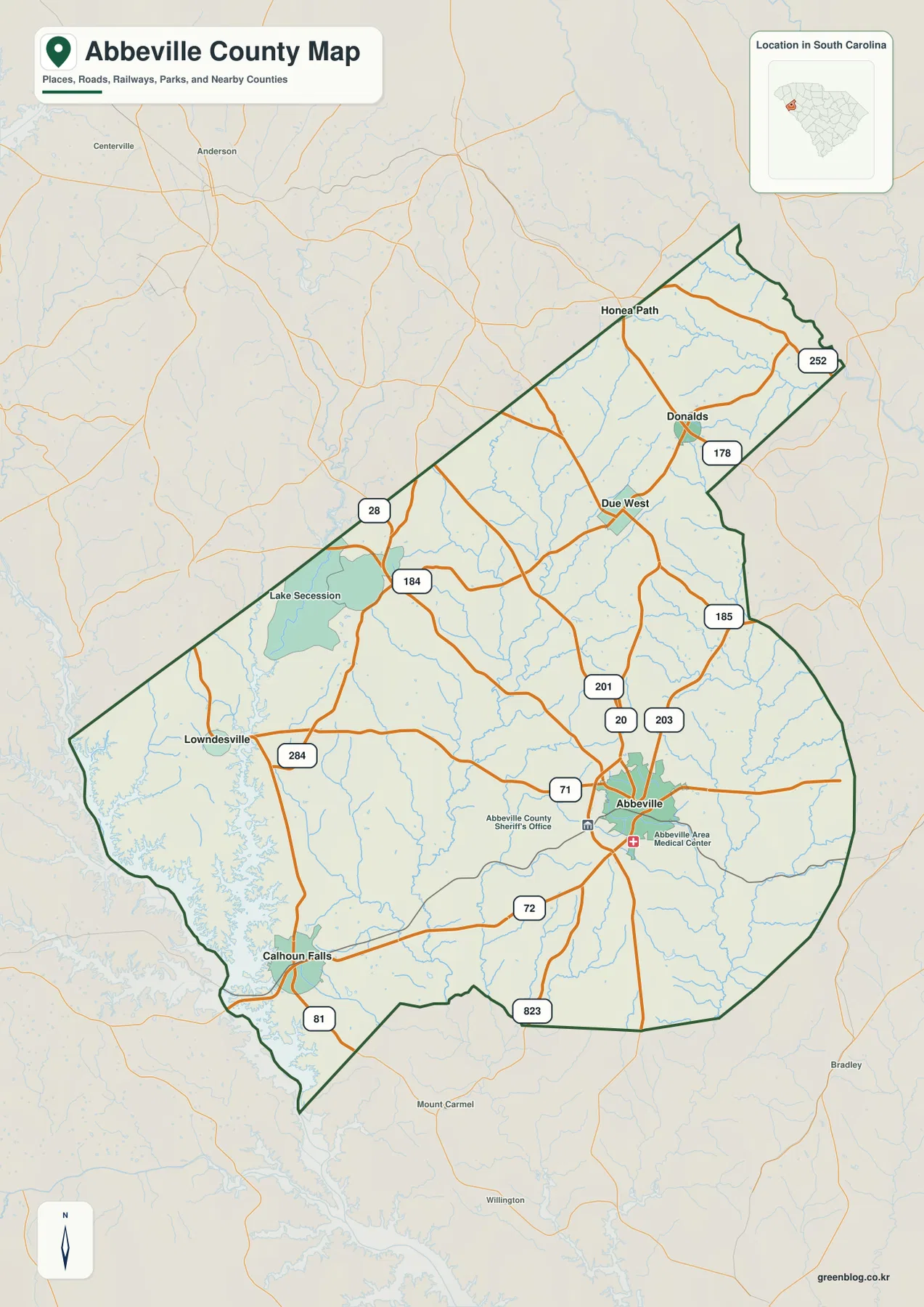
The general county map places Abbeville in the southeastern half of the county and shows several numbered roads converging around it. Routes labeled 20, 71, 72, 201, 203, and 823 are all visible near the city. Farther north, the network reaches Due West and Donalds, with 178, 185, and 252 appearing in the northeastern part of the county. Toward the west and southwest, the map shows 184, 284, and 81 along with roads leading toward Lowndesville and Calhoun Falls. This arrangement gives the county a noticeably distributed settlement pattern: the main named places are separated from one another rather than forming a single continuous urban area.
Lake Secession is one of the clearest water features on this map. It lies in the northwestern interior of the county, where its irregular shoreline contrasts with the more linear road network. Small streams are also visible across the map, but the purpose of this view is to keep roads, settlements, and the county boundary readable at the same time. For that reason, it works well as an orientation map before moving to the more detailed terrain-and-water view.
The Abbeville County Sheriff’s Office and Abbeville Area Medical Center are marked close to the Abbeville label. Those points help locate the developed center, but the map is more useful for understanding county-wide relationships than for locating individual services. To the north, Due West and Donalds create a second cluster of labels, while Lowndesville and Calhoun Falls anchor the western and southwestern side. Honea Path appears near the northern edge, providing another useful reference close to the county boundary.
Town positions and straight-line distances from Abbeville
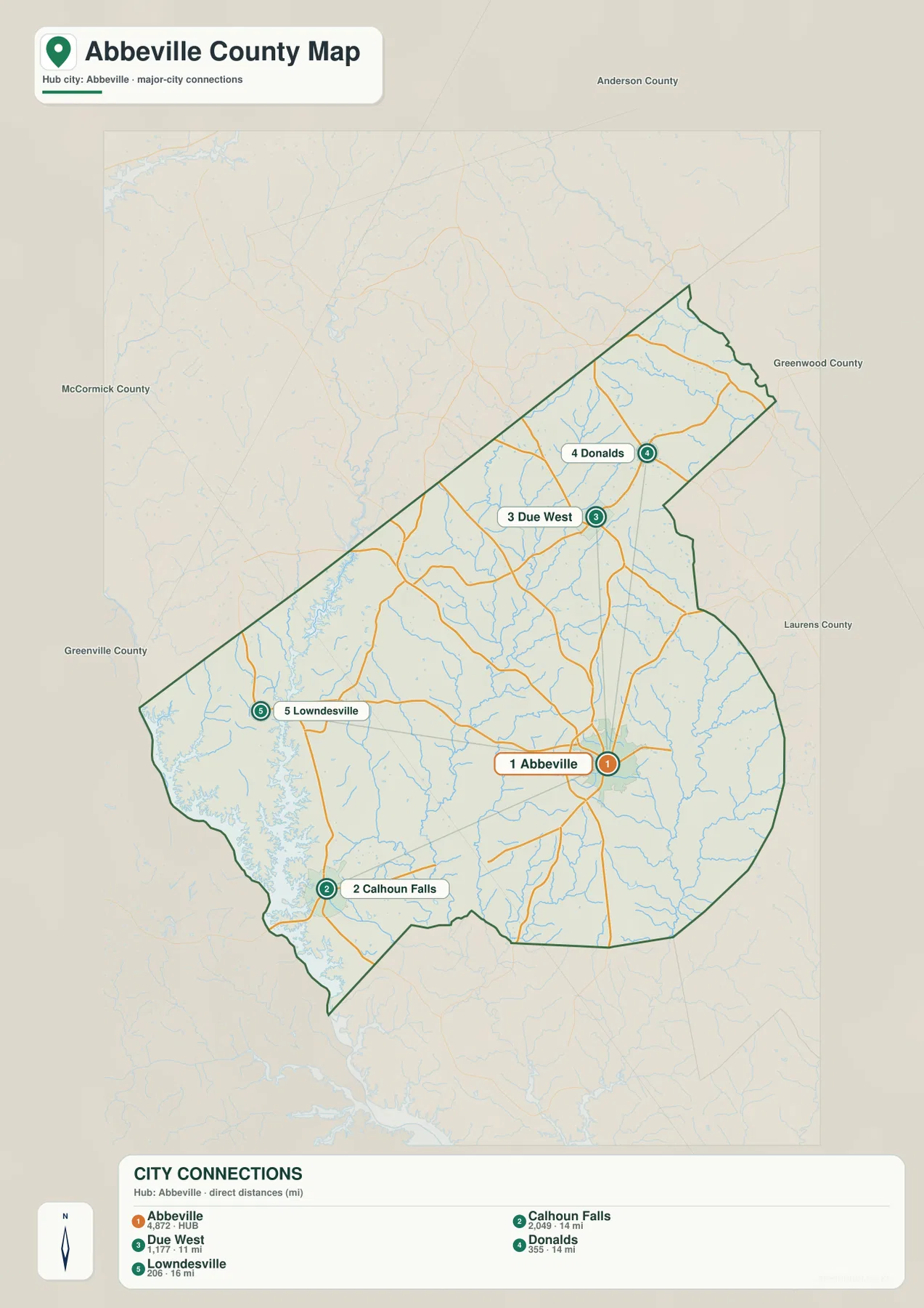
The city-connections map uses Abbeville as the hub and gives a simpler picture of where the other labeled towns sit. Due West is shown about 11 miles from Abbeville by straight-line distance. Donalds and Calhoun Falls are each about 14 miles away, although they are in very different directions: Donalds lies to the north while Calhoun Falls is southwest of Abbeville. Lowndesville is shown roughly 16 miles from the hub on the western side of the county. The distance labels make the county scale easier to understand without requiring a detailed street network.
| Hub | Abbeville |
|---|---|
| Due West | about 11 mi · straight-line |
| Donalds | about 14 mi · straight-line |
| Calhoun Falls | about 14 mi · straight-line |
| Lowndesville | about 16 mi · straight-line |
These values should not be read as driving mileage. Roads bend around waterways and follow different corridors, so a road trip between the same two places can be longer than the connector shown here. The map answers a more basic geographic question: how far apart are the named towns in direct distance, and in which direction do they sit from Abbeville? That makes it useful when someone wants a quick county-level comparison without the visual clutter of every road and local street.
The layout also highlights the fact that Abbeville is not centered geometrically within the county. Due West and Donalds extend the settlement pattern northward, while Lowndesville and Calhoun Falls pull it west and southwest. Calhoun Falls is especially distinct because it sits close to the broad water area along the southwestern side of the county. In contrast, the northern towns lie among a denser web of small streams and roads. Those differences are easier to notice in the map than in a list of town names.
For a classroom or presentation, this view can be paired with the general county map to explain two separate ideas without mixing them together. The first map shows the actual road network and boundary; the city-connections map shows relative spacing. A reader can quickly see why two towns with similar straight-line distances from Abbeville can occupy very different parts of the county and have different road approaches.
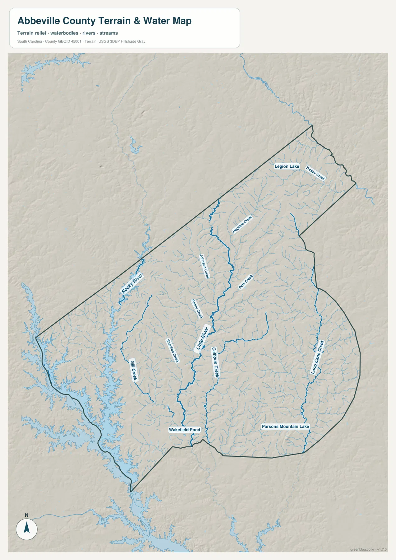
Little River, Rocky River, and a dense creek network
The terrain-and-water map reveals a different structure beneath the road network. The Little River is the most prominent named watercourse through the center of the county. Johnson Creek, Penny Creek, Park Creek, and Calhoun Creek join or approach the central river system from different sides. On the western side, Rocky River and Gill Creek stand out, while Long Cane Creek traces a long course near the eastern edge. In the northeast, Turkey Creek and Legion Lake provide two additional named water features.
The Little River is not drawn as a single straight channel. It bends through the middle of the county and receives numerous smaller tributaries, which gives the central area a branching appearance. Rocky River and the western creeks form another visible group of channels, especially toward the large, irregular water area beyond the southwestern boundary. Because that larger water body is not named on the supplied image, this article does not assign it a name. The map itself is enough to show that Calhoun Falls and the southwestern corner are much closer to broad open water than the northeastern towns are.
Wakefield Pond is labeled near the southern part of the Little River system, and Parsons Mountain Lake appears farther east. Around both, fine blue tributary lines follow the lower parts of the shaded terrain. The hillshade does not provide survey-grade elevations, but it does make the local relief visible: ridges and shallow valleys repeat across the county rather than forming a broad, uniformly flat plain. This is the kind of rolling Piedmont landscape where even small streams can define noticeable local valleys.
The water map should be used as a hydrographic and terrain reference, not as a flood map. A creek shown near a road or settlement does not by itself indicate that the location is flood-prone. Flood risk requires separate official flood information and site-specific conditions. For understanding which named streams cross the county, how tributaries feed the Little River, and where small lakes sit relative to the county outline, however, this view is more informative than the road-focused map.
What becomes clearer when the three map views are compared
Each supplied map answers a different practical question about Abbeville County. If the task is to locate towns, numbered roads, Lake Secession, and the county outline in one view, the general county map is the best starting point. If the task is to compare the position of smaller towns from Abbeville without getting distracted by the full road network, the city-connections view is faster. If rivers, creeks, lakes, and the shape of the terrain matter most, the terrain-and-water map puts those features first.
Calhoun Falls is a good example of why this separation matters. On the county map, the town is easy to place near roads 72 and 81 in the southwest. On the city-connections map, the main fact is its roughly 14-mile straight-line distance from Abbeville. On the water map, the surrounding setting changes again, because the southwestern edge is dominated by a broad water surface and branching tributaries. One place therefore has three useful geographic descriptions: road position, relative distance, and water-setting context.
Due West and Donalds tell a different story. The county map links them to the northern road network, while the connector map makes their northward relationship to Abbeville obvious. In the water view, that part of the county is crossed by smaller creeks, including Johnson Creek, Hogskin Creek, and Park Creek in the broader northern and central area. The contrast between these towns and Calhoun Falls helps explain why a single all-purpose map would be harder to read than separate files with different priorities.
Lake Secession provides another useful comparison. Its name and shoreline are easy to spot on the general map because the lake is shown alongside the road network and nearby place labels. The water map, by contrast, gives more visual weight to the Little River and its tributaries. Neither map is “better” in a general sense; the useful choice depends on whether the reader needs settlement-and-road context or a clearer picture of waterways and relief.
Choosing a file for print, reports, or closer map reading
The WebP images on this page are optimized for convenient viewing in a browser. When small tributaries, road labels, or town names need to remain legible after enlargement, the JPG files in the download archive are the better choice. Each JPG is prepared at 2572 by 3638 pixels, an A3-oriented size that provides more room for fine labels than the page preview. The terrain-and-water map benefits most from the extra resolution because it contains many thin stream lines.
For a county overview, use the general map when roads and named places need to appear together. Use the city-connections map when a document needs a simple explanation of how Due West, Donalds, Calhoun Falls, and Lowndesville relate to Abbeville. Use the terrain-and-water map when the subject is the Little River network, Rocky River, Long Cane Creek, lakes, ponds, or the rolling relief. Choosing one focused map usually communicates more clearly than shrinking several complex layers into the same image.
The files are reference maps rather than legal or engineering products. They should not replace parcel records, survey plats, emergency routing, flood-hazard determinations, or field measurements. Within their intended scope, they are useful for county comparison, educational material, local geography notes, presentations, and printable map collections because the same county can be shown with different amounts of road, settlement, and water detail.
Frequently Asked Questions
Is the 14-mile Abbeville–Calhoun Falls distance a driving distance?
No. The city-connections map labels a straight-line distance of about 14 miles between Abbeville and Calhoun Falls. Actual driving mileage depends on the road used and the exact start and end points, so a navigation service should be used for travel planning.
Which file is best for seeing the Little River and Long Cane Creek?
Use the terrain-and-water map. It emphasizes the Little River through the middle of the county and also labels Long Cane Creek, Rocky River, Johnson Creek, Park Creek, Calhoun Creek, and several other water features. The general county map is better when roads and towns are the priority.
Can I see Lake Secession and the Calhoun Falls area in the same map set?
Yes. Lake Secession is clearly labeled on the general county map, while Calhoun Falls is shown in the southwest on both the county map and the city-connections map. The terrain-and-water view adds the nearby river and tributary setting, so the three files complement one another without duplicating exactly the same information.
Map File Information
The ZIP contains the county map, city-connections map, and terrain-and-water map as high-resolution A3 JPG files. Use the JPG versions when you need more detail for printing, a report, or a larger on-screen view than the WebP previews.
- Included Files: county map, city-connections map, terrain-and-water map
- Printable Size: 2572 × 3638 px each
- File Type: ZIP with 3 high-resolution JPG images
Related Maps
Sources
The article description is based primarily on the supplied Abbeville County map images. The following official resources are useful for checking the underlying county-boundary, hydrography, and terrain data represented in this type of map.
- South Carolina Association of Counties – County Information: county reference information
- U.S. Census Bureau TIGER/Line Shapefiles: county boundaries, roads, and geographic reference data
- USGS National Hydrography: rivers, streams, lakes, and other hydrographic data
- USGS 3D Elevation Program: elevation and terrain data used for shaded-relief context
Green Map creates custom-edited map images using open geographic data sources such as geoBoundaries, Natural Earth, OpenStreetMap, and government open data.
These maps are edited visual materials, not raw data files, and are provided for education, documents, presentations, and graphic reference.