This Allendale County Map is built for more than a quick boundary check. The county map shows how Allendale, Fairfax, Sycamore, and Ulmer sit among numbered routes; the city map strips the view down so those four places can be compared without distraction; and the terrain-and-water map brings the Coosawhatchie River, Salkehatchie River, named creeks, and a surprising number of ponds into focus. Matching A3 high-resolution JPG files are available in the download ZIP on this page.
The three views are especially useful together because Allendale County does not read the same way from roads as it does from water. Allendale occupies the central part of the county and serves as the clearest orientation point. Fairfax lies southeast of it, while Sycamore and Ulmer sit farther northeast. Once those places are located, routes 278, 301, 321, 641, 125, and 3 help explain movement through the county. Switch to the water map, however, and the center of attention shifts to river and creek lines crossing broad, gently shaded terrain.
Table of Contents
Allendale as the center of the road picture
The main county map makes Allendale the easiest place to find. Its label sits near the middle of the outline beside the Allendale County Sheriff’s Office marker, and several orange road lines converge in the same general area. Fairfax appears to the southeast, close to the county’s eastern side. Sycamore is northeast of Allendale, and Ulmer is farther north near the upper-right edge. This arrangement gives the county a clear central-to-northeastern chain of named places rather than one compact cluster.
Route numbers add a second layer of orientation. The line marked 278 passes through the Allendale area on an east-west course. Route 301 runs through the northeastern part of the county near Ulmer and Sycamore, while 321 descends through the Sycamore–Fairfax side. Route 641 links the central and northeastern area, 125 crosses the upper-left portion, and route 3 appears in the south. You do not need a full street map to see that the road network is spread across several different directions rather than following a single corridor.
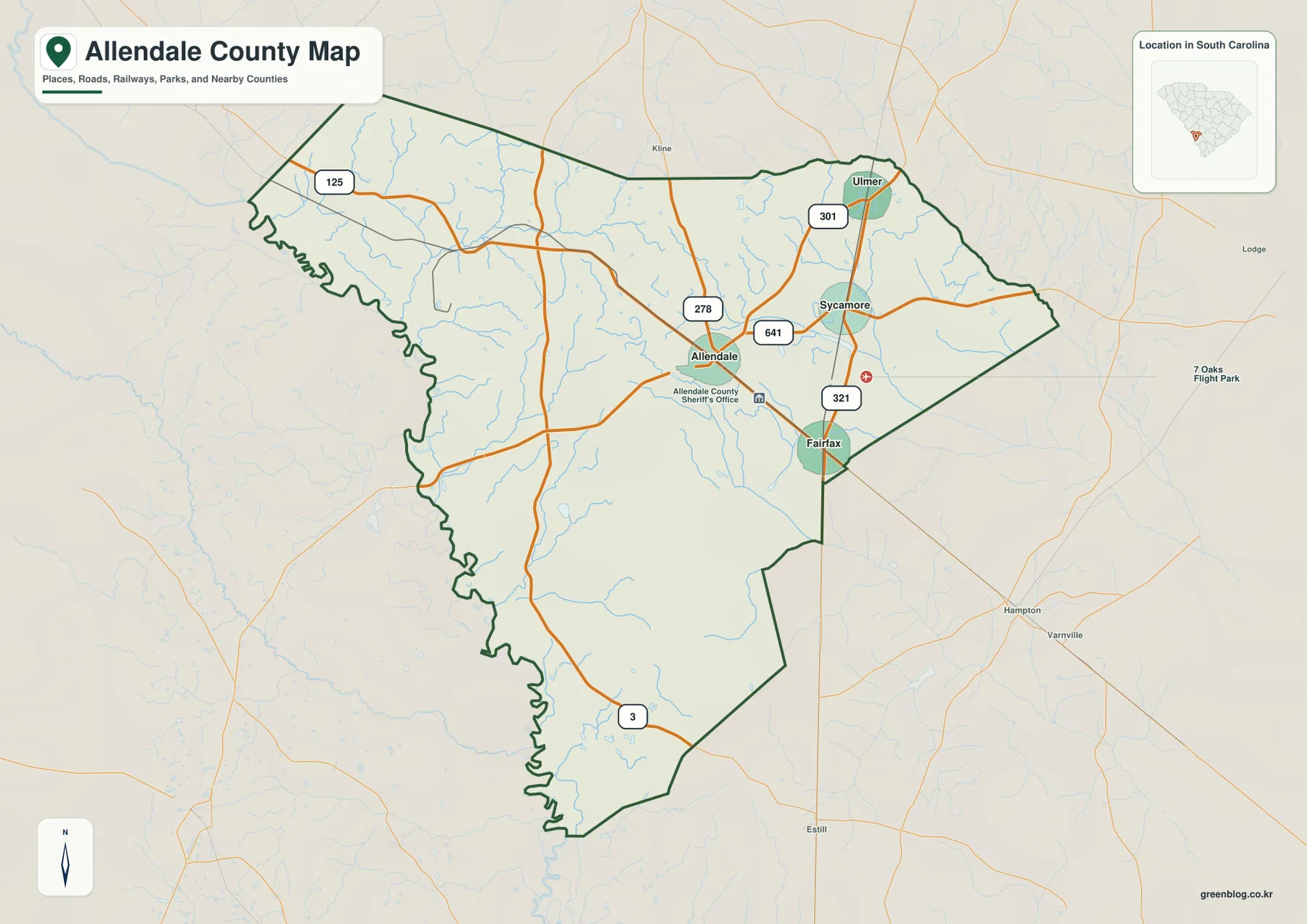
The outline itself is worth noticing. The western side is deeply irregular and remains sinuous for a long distance toward the south, while much of the eastern and southeastern boundary is made of straighter segments and sharper turns. The county narrows toward its southern tip, but the northern half opens more broadly, especially around the Ulmer side. That combination of a winding west edge, a wider north, and a tapered south makes Allendale County recognizable even before individual place names are read.
The four-place pattern from Allendale to Ulmer
The city map removes most of the detail and ranks four labeled places: Allendale first, Fairfax second, Ulmer third, and Sycamore fourth. Allendale remains near the middle of the county. Fairfax is lower and farther east, Ulmer is close to the northeastern edge, and Sycamore falls between the central and northeastern group. The map’s city index also displays the figures 2,653 for Allendale, 1,935 for Fairfax, 190 for Ulmer, and 68 for Sycamore. Here they are best treated as the values shown by the supplied map rather than as a substitute for a current demographic table.
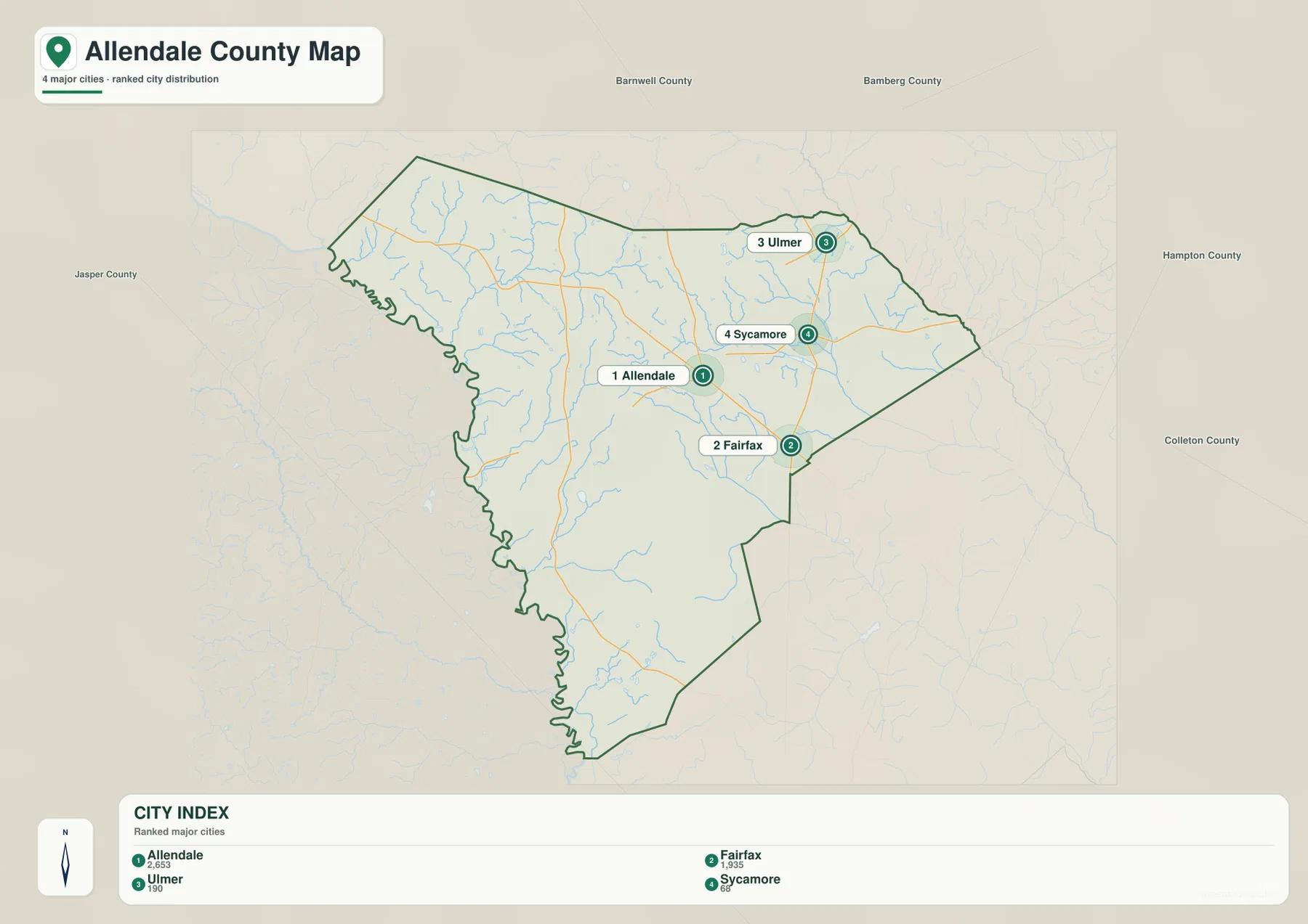
Labels outside the county provide a wider South Carolina reference field. Barnwell County and Bamberg County appear above the map, Hampton County and Colleton County to the right, and Jasper County to the left. Those labels are useful for orientation without turning the city map into a dense boundary diagram. They also make the position of the four internal places easier to describe: Ulmer and Sycamore are on the northern and northeastern side of the county, Fairfax is toward the southeast, and Allendale occupies the central reference position.
A county crossed by named rivers, creeks, and ponds
The terrain-and-water map changes the story completely. The Coosawhatchie River runs through the central-to-southeastern part of the county, while the Salkehatchie River is prominent on the eastern side. Jackson Creek lies between and near these larger waterways. In the northwest, Lower Three Runs Creek and Miller Creek stand out; farther west and southwest, Brier Creek and Gulf Creek add separate drainage lines. The result is a map with named water features in several parts of the county instead of one dominant river confined to a single edge.
The smaller water bodies are just as distinctive. Browns Pond, Myers Pond, Furse Pond, and Terry Pond are grouped in the northwestern area. Tutens Millpond appears east of the county center, Harters Pond lies farther south along the central water network, and Bull Pond is marked in the southwest. Because these names are spread across different parts of the county, they serve as useful landmarks when the road labels are not the main focus.
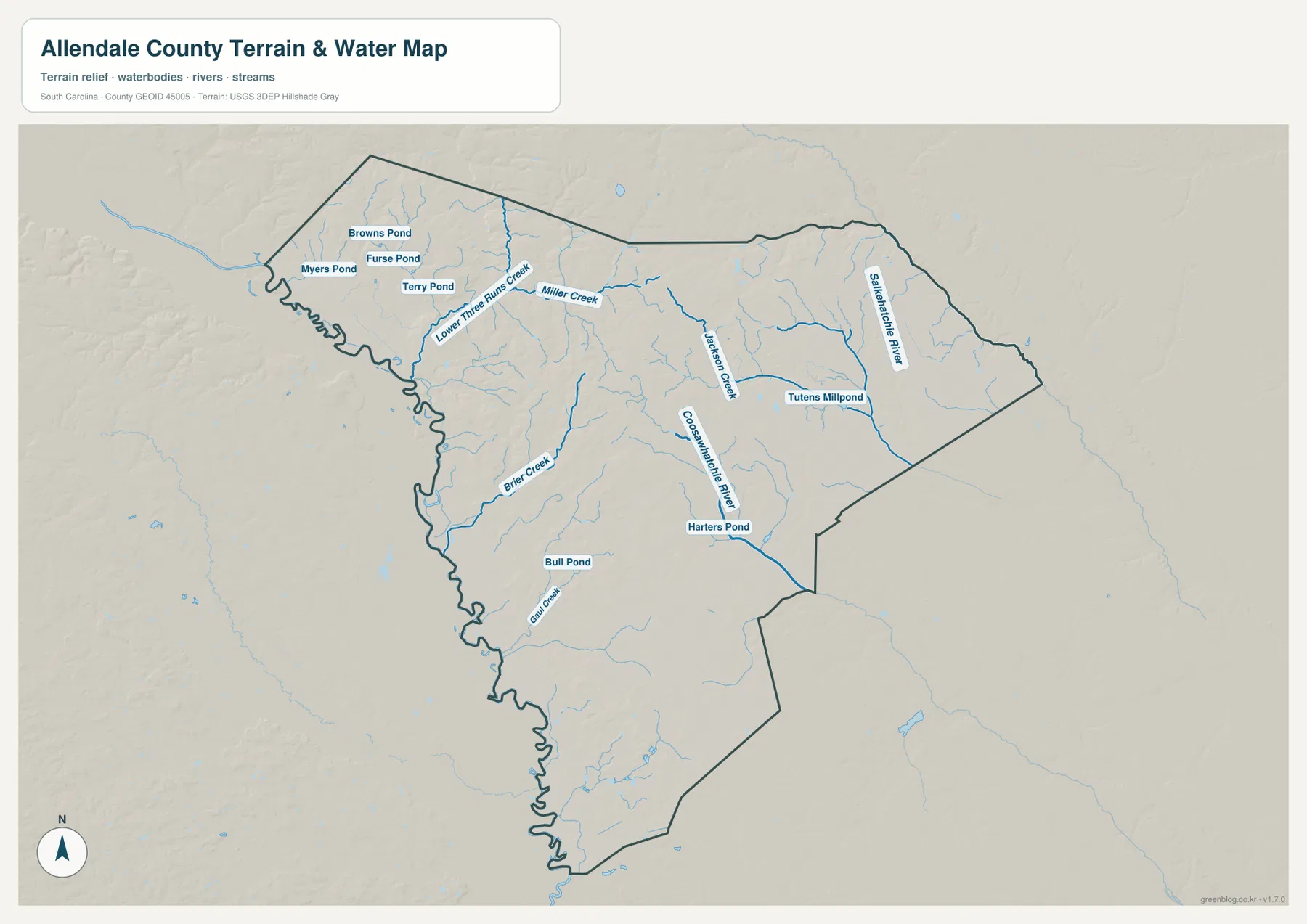
The shaded background is relatively subdued, so the water network is more visually important than dramatic elevation changes. Instead of looking for steep mountain relief, it is more useful to follow how creeks lead toward the larger river lines and how those channels relate to the county boundary. The contrast is particularly clear between the irregular western edge, the central Coosawhatchie River corridor, and the Salkehatchie River near the east. This is the kind of physical detail that the road-oriented county map cannot show on its own.
Which map view works best for your task?
For a general county reference, start with the county map. It combines the boundary, four named places, major route numbers, and a small South Carolina locator. It works well when you need to explain where Allendale County sits and how its central and northeastern places connect. If the goal is to compare settlement positions without road clutter, the city map is faster to read because it gives Allendale, Fairfax, Ulmer, and Sycamore clear rank markers.
The water map is the better choice for physical geography. It is the only view in this package where the Coosawhatchie River, Salkehatchie River, Lower Three Runs Creek, Jackson Creek, Brier Creek, Miller Creek, Gulf Creek, and named ponds can be read directly. Using the three files separately keeps each image legible. A presentation can use the city map for place distribution, a local-reference handout can use the county map for roads, and an environmental or geography lesson can use the water map without forcing all of those labels onto one crowded graphic.
County reference facts to read beside the maps
| State | South Carolina |
|---|---|
| County | Allendale County |
| County seat | Allendale |
| Founded | 1919 |
| Existing SCAC reference population | 8,039 |
| Land area | 408 sq mi |
| Places labeled in the city map | Allendale, Fairfax, Ulmer, Sycamore |
The administrative and size figures above are retained from the existing SCAC-based material supplied in this rewrite package. They work best as background for the maps rather than as the main subject. What the graphics add is the internal arrangement: Allendale near the center, Fairfax toward the southeast, Ulmer and Sycamore in the northeast, a long irregular western side, and a network of named waterways that is much more detailed than the previous boundary-only article suggested.
Details worth checking when you zoom in
- Central Allendale: several numbered roads converge around the county’s main orientation point.
- Fairfax side: Fairfax lies near the southeastern boundary and close to the north-south route marked 321.
- Northeast: Sycamore and Ulmer sit relatively close together, with route 301 running through this part of the county.
- Northwest water features: Lower Three Runs Creek sits near a cluster of Browns, Myers, Furse, and Terry ponds.
- Central and eastern waterways: the Coosawhatchie and Salkehatchie river lines create a different set of reference points from the roads.
- Southwest: Gulf Creek and Bull Pond appear near the county’s narrowing southern half.
These details also make the Allendale County page less interchangeable with other county-map pages. The map has its own combination of four ranked places, a road network centered on Allendale, a sharply winding western edge, and named waterways spread from the pond-rich northwest to the river corridors in the center and east. If you are comparing several South Carolina counties at the same print size, those are the features that help identify this one quickly.
Frequently Asked Questions
How can I tell Allendale and Fairfax apart on the map?
Allendale is near the center of the county where several road lines converge and the sheriff’s office marker appears. Fairfax is southeast of Allendale, close to the county edge and the route marked 321. The city map reinforces the distinction by ranking Allendale first and Fairfax second.
Which named waterways are easiest to find in Allendale County?
The terrain-and-water map prominently labels the Coosawhatchie River and Salkehatchie River. It also labels Lower Three Runs Creek, Brier Creek, Jackson Creek, Miller Creek, and Gulf Creek, along with several ponds and Tutens Millpond. These names provide useful reference points across the northwest, center, east, and southwest portions of the county.
Can I download a larger Allendale County map for printing?
Yes. The images in the article are web previews, while the ZIP contains separate 3638 × 2572-pixel A3 JPG files for the county map, city map, and terrain-and-water map. Use the JPG files when you need a larger print or a high-resolution image for a document.
Map File Information
The download ZIP contains high-resolution A3 JPG versions of all three maps shown on this page. Each file is separate, so you can use the county, city, or terrain-and-water view on its own for printing, documents, classroom materials, or comparison work.
- Included Files: 3 high-resolution A3 JPG map files shown in this article
- File Type: JPG files in a ZIP archive
- Intended Use: Printing, education, presentations, and map-based projects
Related Maps
Sources and Reference Data
- South Carolina Association of Counties – County Information: county seat, area, and existing county reference figures
- U.S. Census Bureau TIGER/Line Shapefiles: county boundary and road reference data
- USGS National Hydrography: river, creek, and waterbody reference data
- USGS 3D Elevation Program: elevation and shaded-relief reference data
- South Carolina Geological Survey: regional geology and physical-geography references
Green Map creates custom-edited map images using open geographic data sources such as geoBoundaries, Natural Earth, OpenStreetMap, and government open data.
These maps are edited visual materials, not raw data files, and are provided for education, documents, presentations, and graphic reference.