Burleson County sits in east-central Texas between the Austin side of the state and the Bryan–College Station area. This page provides a Burleson County Map you can view online and download as high-resolution A3 JPG files in a ZIP for printing, classroom use, or offline reference. Caldwell is the most useful starting point because State Highways 21 and 36 meet there, while Somerville lies to the south and Snook is farther east toward the Brazos River side of the county. Once those three places are fixed in your mind, the roads radiating from Caldwell, the higher western ground, and the lower Brazos basin along the east become much easier to place.
The page separates the county into four views instead of forcing every detail onto one sheet. The general county map keeps towns, roads, rail lines, streams, and nearby places together. The city map simplifies the settlement pattern around Caldwell, Somerville, and Snook. The water map brings the Brazos River, Old River, and interior creeks forward, while the elevation map removes most labels so that the west-to-east change in relief is easy to see. The downloadable files match these four subjects, so you can choose the version that fits the task without enlarging a browser preview.
The strongest local contrast is not between a dense urban core and an empty rural fringe. Instead, Burleson County has several small communities separated by large areas of open countryside, with two major highways crossing at Caldwell and a much wetter, lower landscape along the eastern side. Lake Somerville adds another geographic reference to the south, where the Yegua Creek system reaches the reservoir. Reading the maps together helps distinguish the county’s civic center, its scattered towns, its drainage network, and its higher western terrain without treating them as the same kind of information.
Table of Contents
Caldwell at the crossing of Highways 21 and 36
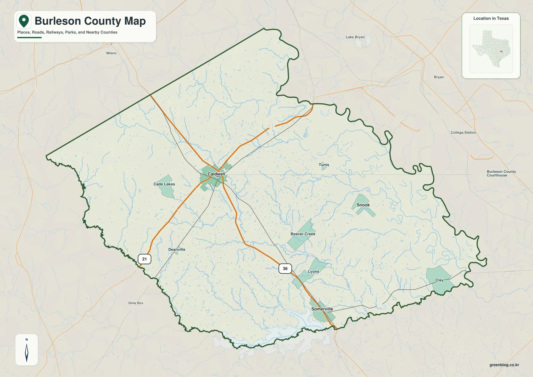
Caldwell appears slightly north of the visual center of the county and acts as the clearest road reference. The Handbook of Texas identifies it as the county seat and notes that State Highway 36 is the main north–south route while State Highway 21 crosses the county east to west. That relationship is visible on the map: Highway 21 continues toward the Bryan and College Station side of the region, and Highway 36 runs south through the county toward Somerville. When you are trying to orient a printed map, finding this intersection first prevents the smaller county roads from becoming a wall of similar-looking lines.
The outer labels give the county a useful frame. Milam County and Robertson County are to the north, Lee County is to the west, Washington County is along the south, and Brazos County lies to the east. Bryan and College Station appear outside the Burleson boundary, which helps show why the eastern side of the county feels closely connected to the larger Brazos County population center even though it remains a separate jurisdiction. The map is especially useful for this kind of regional orientation because the neighboring labels remain visible instead of cropping the image exactly at the county line.
Inside the boundary, the map marks more than the three best-known towns. Lyons, Deanville, Tunis, Clay, and the Beaver Creek area provide smaller reference points for rural parts of the county. Lyons sits near the Highway 36 corridor between Caldwell and Somerville, while Clay is near the southeastern side closer to the Brazos River. Deanville gives the western half of the county a named point that is useful when comparing roads with the higher terrain shown later on the elevation map. These smaller labels matter because Burleson County does not have a continuous built-up area connecting its communities.
Somerville and Snook show how widely the towns are spread
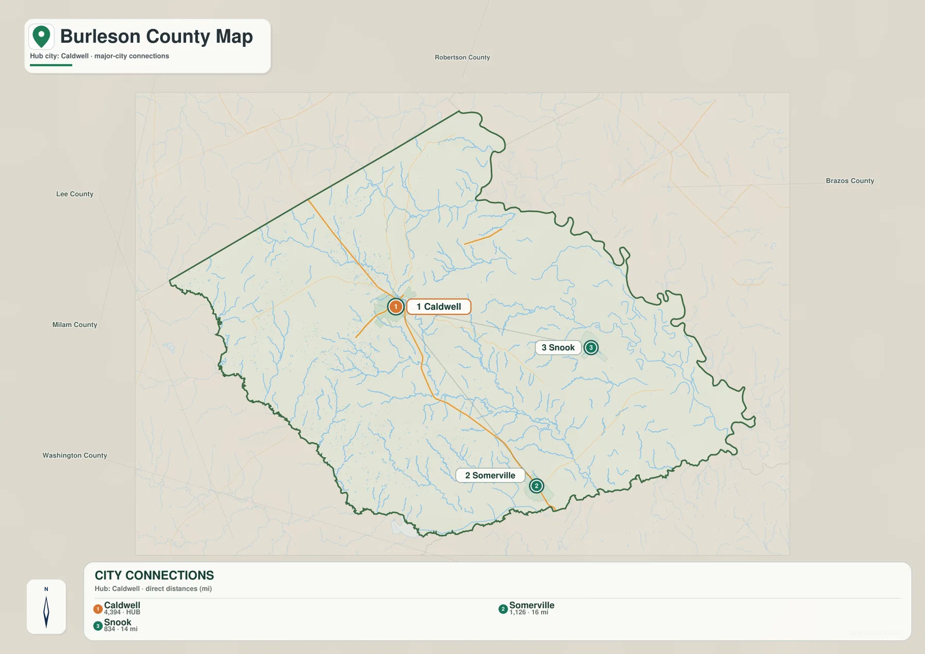
The city map strips away many secondary labels and makes the three main reference towns much more obvious. Its distance guide places Somerville about 16 miles from Caldwell and Snook about 14 miles from Caldwell by direct distance. Those figures are not driving directions, but they show the basic geometry well: Somerville and Snook are not on the same corridor, and a trip between them does not simply pass along one straight county spine. Caldwell is the central hub, Somerville anchors the southern part of the map, and Snook provides an eastern reference nearer the Brazos side.
This simplified view is useful when the purpose is to explain where people and services are concentrated rather than to inspect every creek or local road. Highway 36 creates the clearest Caldwell-to-Somerville connection, while the eastward road network from Caldwell and the surrounding county roads lead toward Snook and eventually the Bryan–College Station side. The map also makes the empty distance between communities visible. That spacing is important in a largely rural county because a place that looks close on a statewide map may still be separated from the next town by many miles of farms, ranches, wooded tracts, and local roads.
For route planning, use the city map to choose the correct general direction and then switch back to the county map for the actual network. If your destination is west of Caldwell near Deanville, the three-city diagram alone is too simple. If the goal is only to show a class where Somerville and Snook sit relative to the county seat, however, the simplified map is clearer than a busier road sheet. The two maps are intentionally different: one establishes the town pattern quickly, and the other supplies the detail needed after that pattern is understood.
The Brazos River edge and the county’s interior creeks
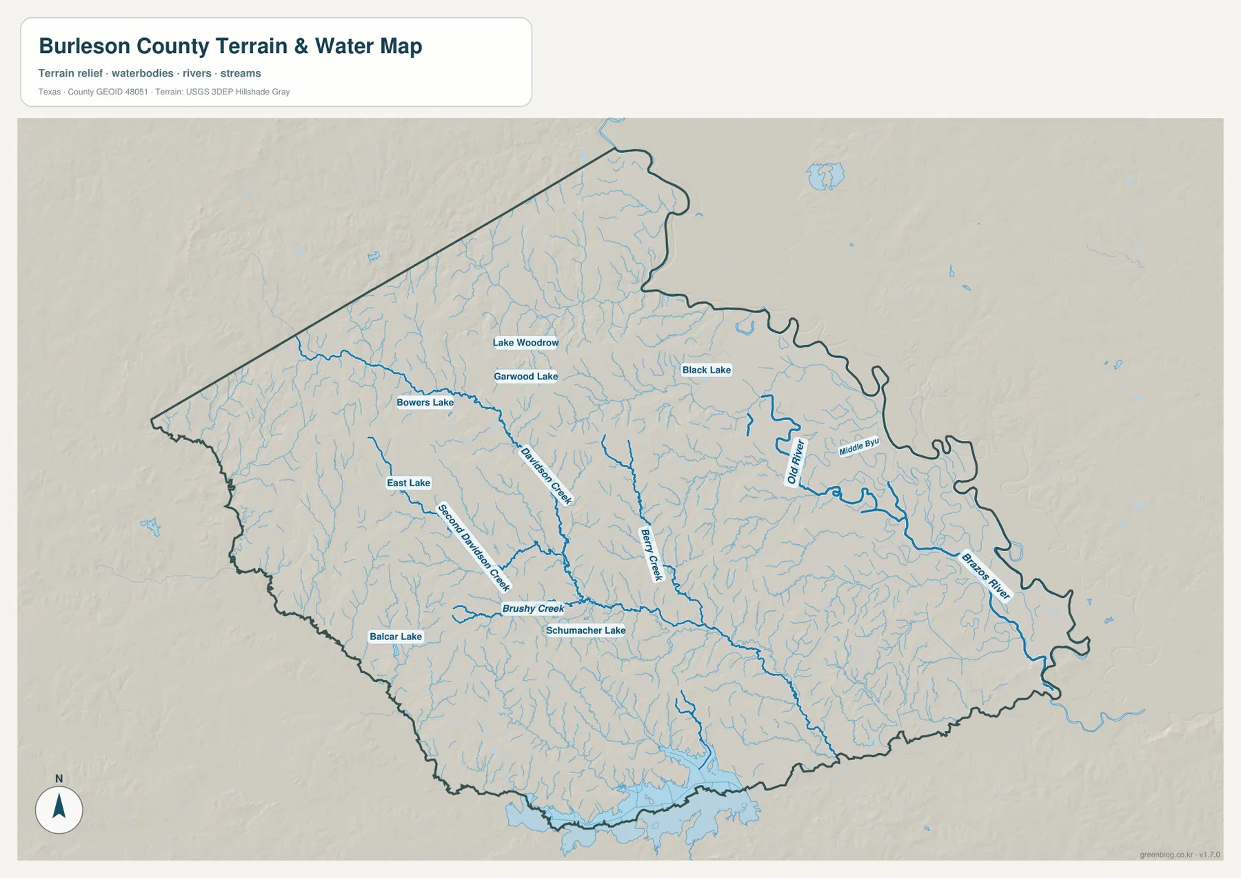
On the water map, the Brazos River forms the dominant line along the eastern side. Old River runs roughly parallel to it farther west, and a dense network of smaller streams drains the interior. Davidson Creek and Second Davidson Creek are easy to follow in the western and central area, while Berry Creek and Brushy Creek stand out farther south. This view explains why the pale blue stream lines seen on the county map are not random decoration. They form a connected drainage network that becomes much easier to trace when roads and town labels are reduced.
Several smaller named water bodies also appear, including Bowers Lake, Lake Woodrow, Garwood Lake, Black Lake, East Lake, Balcar Lake, and Schumacher Lake. None of these should be mistaken for a county-wide lake comparable in scale to Lake Somerville. Their value on this map is local: a small lake can help identify a rural location that would otherwise be surrounded by similar roads and creek branches. Black Lake, for example, gives the northeastern interior a clear label near the Old River system, while Balcar Lake and Schumacher Lake provide references in the southwestern half.
Lake Somerville belongs to a different scale of reference. The U.S. Army Corps of Engineers places Somerville Lake on Yegua Creek in the southern part of Burleson County and the northern part of Washington County, with upper reaches extending toward Lee County. The county water sheet emphasizes the interior drainage rather than turning the reservoir into the only subject, so it is best to use the lake as southern context. Find the town of Somerville on the city or county map, then look south toward the Yegua Creek system to understand how the reservoir relates to the county boundary.
Higher western uplands descend toward the eastern lowlands
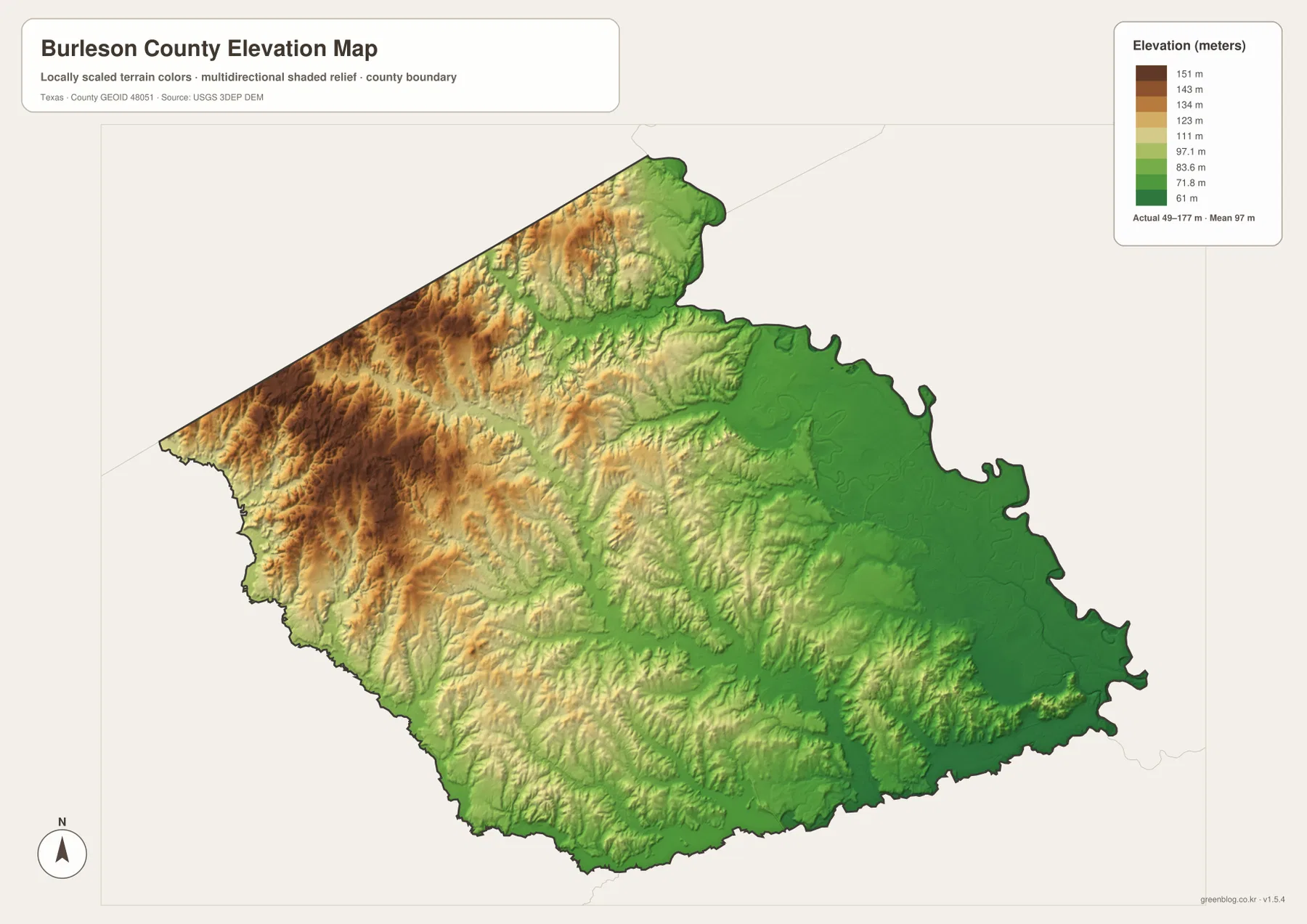
The elevation map has one of the clearest visual messages in the set. Its locally scaled data show an actual range of about 49 to 177 meters, with a mean near 97 meters. Brown and tan tones dominate much of the western and northwestern side, where narrow ridges and shallow valleys create a rougher surface. Greens become broader toward the east, especially near the Brazos side, indicating lower terrain. The county is not mountainous, but the difference is large enough to change how the landscape looks and how small streams descend across the interior.
The pattern agrees with the broader geographic description of Burleson County as rolling or hilly across much of the uplands and much flatter in the Brazos alluvial valley. The map makes that general statement specific. A viewer can point to the higher western corner, follow the gradual transition through the center, and then see the lower eastern band without needing contour-line experience. That is why this version works well for readers who want a quick terrain comparison rather than a technical topographic analysis.
Pairing this sheet with the water map is especially revealing. Many small creeks begin or pass through the more varied western and central terrain before joining larger channels farther east or south. The low eastern corridor also helps explain why the Brazos River and Old River occupy such a prominent part of the water map. If you are comparing two locations, identify them first on the county map and then transfer their positions to the elevation sheet. That keeps the colors tied to real towns and roads instead of leaving them as an abstract gradient.
Lake Somerville changes the southern geographic context
Somerville the town and Lake Somerville the reservoir are close enough in name to be confused, but they are not the same location. The Army Corps of Engineers describes the lake as lying south of Somerville on Yegua Creek. It spans the southern part of Burleson County and the northern part of Washington County, and its upper reaches extend westward toward Lee County. This matters when using a county map because a label for Somerville does not mark the center of the reservoir itself. The town should be treated as the nearby settlement reference, while the lake occupies a broader water area along the southern county context.
The reservoir also helps explain why Yegua Creek is more than a small local stream name. It is part of the drainage system that reaches the Brazos River, and the lake was built for flood-control and water-management purposes as well as recreation. A county overview does not need boat ramps, campsite locations, or current park operations to show this relationship. Those details change and belong on agency recreation pages. For geographic use, the important point is that the southern edge of Burleson County connects to a major reservoir system rather than ending in an isolated straight line.
If your main interest is Lake Somerville recreation, use the official Corps or Texas Parks and Wildlife information after locating the reservoir in the county context. If your interest is the county itself, keep the reservoir in proportion with the rest of the map. Caldwell remains the road and government reference, the Brazos dominates the eastern drainage, and the western uplands remain a separate terrain feature. The lake is important, but it is one part of a county whose geography is spread across several distinct zones.
Moving between the four maps without losing your place
A practical way to use the set is to follow one location through all four views. Start with Snook on the city map. Move to the county map and note its position east of Caldwell, then open the water map and look at the nearby Old River and Brazos River network. Finally, transfer the same eastern area to the elevation map and see how much lower it is than the western side. One place has now connected settlement, roads, water, and terrain without requiring every layer to be crowded into one image.
The same method works in the opposite direction with Deanville or another western location. The county sheet provides the name and road context, while the elevation sheet shows why that part of Burleson County has a rougher appearance. For Somerville, the city map gives the direction from Caldwell, the county map supplies the Highway 36 corridor, and the broader water context explains the nearby Yegua Creek and Lake Somerville system. The repeated county outline makes it possible to switch maps while keeping north, south, east, and west consistent.
This also helps when a map is being used in a report or classroom. A general map is best when the question is “where is it?” A water map is better for “what drains through it?” and the elevation sheet is better for “which side is higher?” The city map answers a narrower question about the spacing of the main settlements. Choosing one map for one question keeps the page readable, while using two complementary maps can show a relationship that would be difficult to explain in a single crowded graphic.
Choosing a file for print, study, or regional comparison
For a printed county overview, the general map is usually the best first page because it includes the largest mix of labels. If the assignment focuses on settlement, add the city map rather than enlarging the town labels manually. If the subject is drainage or the Brazos basin, the water map offers clearer creek names and small lakes. For terrain comparison, use the elevation map in color, because its meaning depends on the contrast between the higher browns and tans in the west and the lower greens in the east.
The web images are sized for comfortable viewing in a browser, while the downloadable JPG files are intended for situations where more pixels are useful. That difference matters on A3 paper, where small labels can become difficult to read if a web preview is stretched beyond its intended size. Keep the full map in frame when placing it in a slide or document so the county boundary and north arrow remain visible. Cropping tightly around Caldwell may remove the eastern river edge or the western uplands that make the county’s geography distinctive.
These maps should be treated as geographic reference graphics rather than turn-by-turn navigation charts. Roads can change, local access can be restricted, and recreation facilities around Lake Somerville may have their own current rules. For current travel decisions, pair the map with an up-to-date road or agency source. For county orientation, education, regional comparison, and a clean printable view of towns, water, and relief, the four-file set gives a consistent base at the same county scale.
Frequently Asked Questions
Where should I start when reading a Burleson County map?
Start with Caldwell, where State Highways 21 and 36 meet. From there, locate Somerville to the south and Snook to the east, then add the Brazos River along the eastern side. Once those references are fixed, the smaller roads, creeks, and rural communities are much easier to place.
Are Somerville and Lake Somerville shown at the same location?
No. Somerville is the town, while Lake Somerville is a reservoir on Yegua Creek south of the town. The reservoir extends across the Burleson–Washington County area, with upper reaches toward Lee County, so the town label should not be used as a substitute for the lake’s full footprint.
Which map best shows the Brazos River side of the county?
Use the water map first because it emphasizes the Brazos River, Old River, and the network of interior creeks. Then compare the same eastern area on the elevation map to see its lower terrain, and return to the county map if you also need nearby towns and major roads.
Sources and reference material
The map set is designed for visual reference. For county history, official water information, boundaries, hydrography, and elevation data, the following sources provide useful supporting detail and more specialized records.
- Handbook of Texas – Burleson County — county location, Caldwell, Highways 21 and 36, the Brazos River, Yegua Creek, and regional terrain.
- U.S. Army Corps of Engineers – Somerville Lake Information — official location and watershed context for Lake Somerville and Yegua Creek.
- USGS The National Map Viewer — official map layers for place names, terrain, hydrography, and other geographic features.
- U.S. Census Bureau TIGER/Line Shapefiles — authoritative boundary and transportation framework data.
- USGS National Hydrography — federal reference information for rivers, streams, and other surface-water features.
- USGS 3D Elevation Program — official information about national elevation data used for terrain products.
Map File Information
The ZIP contains high-resolution A3 JPG versions of the county, city, water, and elevation maps. Use the web images for quick reference, then open the full-size files when you need a cleaner print, classroom handout, or detailed local comparison.
- File Type: JPG
Related Maps
- Robertson County Texas map
- Washington County Texas map
- Bastrop County Texas map
- Williamson County Texas map
- Walker County Texas map
Green Map creates custom-edited map images using open geographic data sources such as geoBoundaries, Natural Earth, OpenStreetMap, and government open data.
These maps are edited visual materials, not raw data files, and are provided for education, documents, presentations, and graphic reference.