This Anderson County South Carolina Map page lets you see the county’s main places, road pattern, and water features, then download matching high-resolution A3 JPG files in one ZIP. Anderson is the strongest central reference on the general map, while Belton, Williamston, Piedmont, Powdersville, Pendleton, Honea Path, Starr, and Iva help show how settlements spread across the county. The terrain-and-water view changes the emphasis completely, with Hartwell Lake on the west and the Saluda River along the eastern side.
The supplied files work best as a set because each one removes some detail and highlights something else. The county map is the quickest way to follow numbered roads and named communities. The ranked city map compares six places without the heavier road background. The water map brings reservoirs, creeks, lakes, rivers, and shaded relief forward, making it much easier to distinguish the lake-dominated western edge from the river-marked eastern side. The article below stays with features actually visible in those files rather than adding street-level or parcel-level claims.
Table of Contents
Roads radiate around Anderson while the county reaches northeast and south
Anderson sits near the middle of the general county map and is surrounded by several of the strongest route lines. The shields for 24, 81, and 178 are close to the city, so Anderson becomes the natural starting point when you want to trace movement across the county. East and northeast of it, Belton, Williamston, Piedmont, and Powdersville create a sequence of named places that can be followed with routes 76, 252, 8, and 29. The map therefore has a denser band of labels in the central-to-northeastern half than at the far southern tip.
The western and southern references are more spread out. Pendleton is toward the northwest side, Centerville is west of Anderson, and Starr and Iva sit in the southern half. Honea Path appears near the southeastern edge. Additional shields such as 85, 88, 182, 187, 184, 185, 20, 28, and 413 show that the county is crossed by routes running in several directions rather than by one single line. This is enough for county-scale orientation, though the image is not intended to replace a detailed street map.
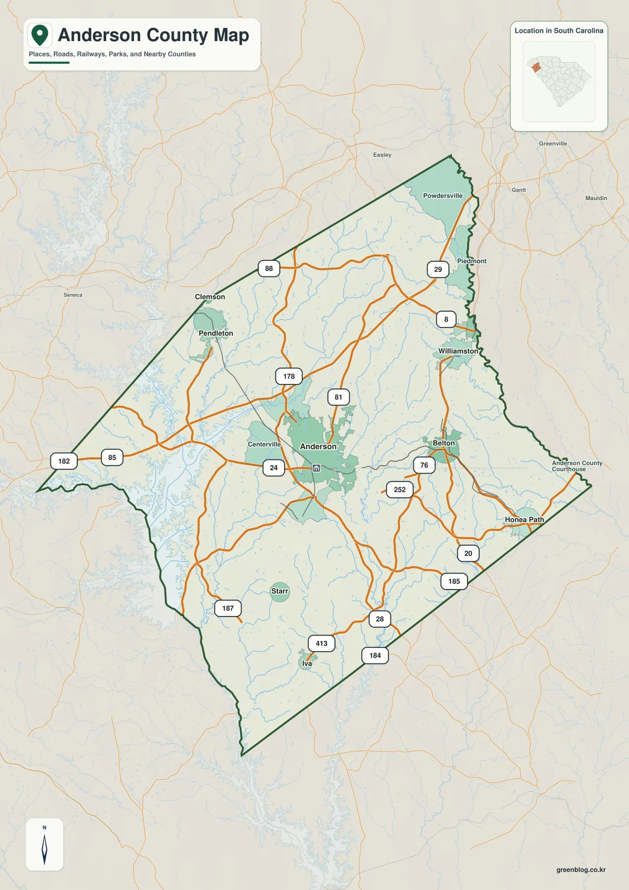
The outline itself gives the page another visual clue. The county is broad across the north and northeast, more irregular along the water-heavy western side, and narrower toward the south. A small state locator in the map places Anderson County in the northwestern part of South Carolina. When the outline, routes, and place names are read together, the county looks less like a simple compact block and more like a long area linking the Hartwell side to a chain of communities toward the northeast and southeast.
Six ranked places reveal a strong center and several smaller outer references
The city map simplifies the picture to six labeled places. Anderson is ranked first and occupies the central position. Belton is second and lies southeast of Anderson, while Williamston is third on the eastern side. Honea Path is fourth near the southeastern edge, Pendleton is fifth toward the northwest, and Pelzer is sixth near the northeastern boundary. That distribution is useful because the six markers are not packed into one cluster: they stretch from Pendleton across Anderson to the eastern and southeastern side of the county.
| Map rank | Place | Value printed on the map |
|---|---|---|
| 1 | Anderson | 30,051 |
| 2 | Belton | 4,458 |
| 3 | Williamston | 4,170 |
| 4 | Honea Path | 3,739 |
| 5 | Pendleton | 3,594 |
| 6 | Pelzer | 1,722 |
Those figures are reproduced from the supplied city map; they are not presented here as newly calculated current population estimates. For the purpose of reading the graphic, the more important point is the difference in scale between Anderson and the other five labels, plus the directional spread of the markers. Belton, Williamston, and Honea Path occupy the eastern half, Pendleton sits on the opposite side, and Pelzer gives the northeast another reference point. If you need the latest demographic numbers, an official statistical source should be checked separately.
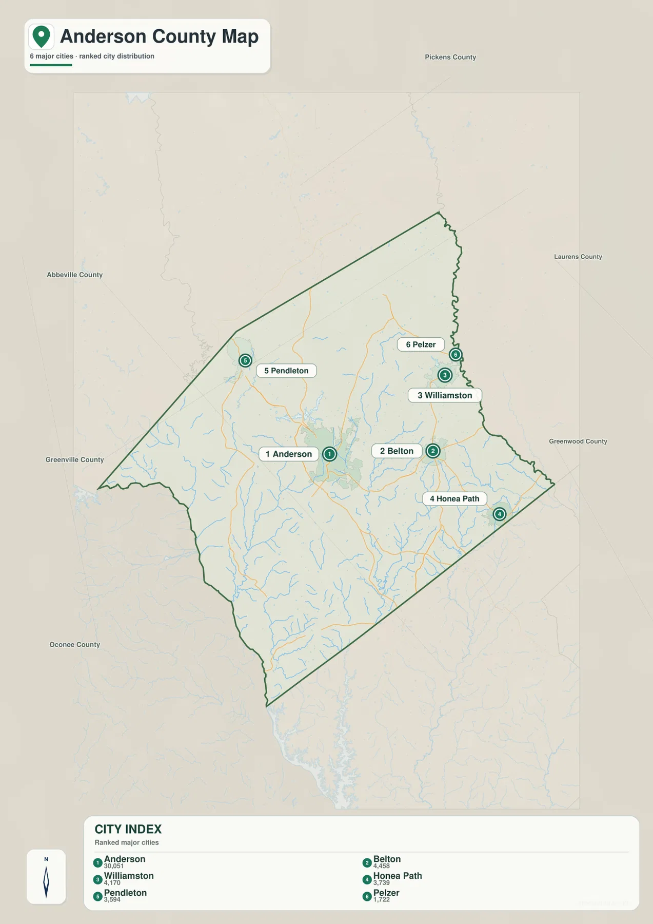
The surrounding county names printed outside the outline provide additional orientation, but this guide does not use them to invent boundary details that are not shown clearly. The city view is most useful for its internal pattern: Anderson in the center, Pendleton toward the northwest, Pelzer near the northeast, and Belton, Williamston, and Honea Path stepping across the eastern half. That pattern is easier to absorb here than on the busier road map.
Hartwell Lake defines the west while the Saluda River marks the east
The terrain-and-water map gives Anderson County a very different identity from the road view. Hartwell Lake occupies a large part of the western edge, with long branching inlets reaching toward the county. Farther south, the Savannah River label continues along the western side. Big Generostee Creek and Little Generostee Creek are also named in this part of the map. These water features provide strong location cues even when road numbers and city labels are removed.
On the opposite side, the Saluda River follows the eastern boundary for a long distance. Inside the county, Three and Twenty Creek is labeled in the northern half. Stoneybrook Lake, Anderson Reservoir, and Morrisons Lake appear in the central-eastern area, while Lake Huntington, Ivester Lake, and Broadway Lake are farther south. Rocky River and Hen Coop Creek add named drainage lines in the lower half. The result is not one dominant river system drawn through the center, but a county where large boundary waters and many internal streams and lakes share the map.
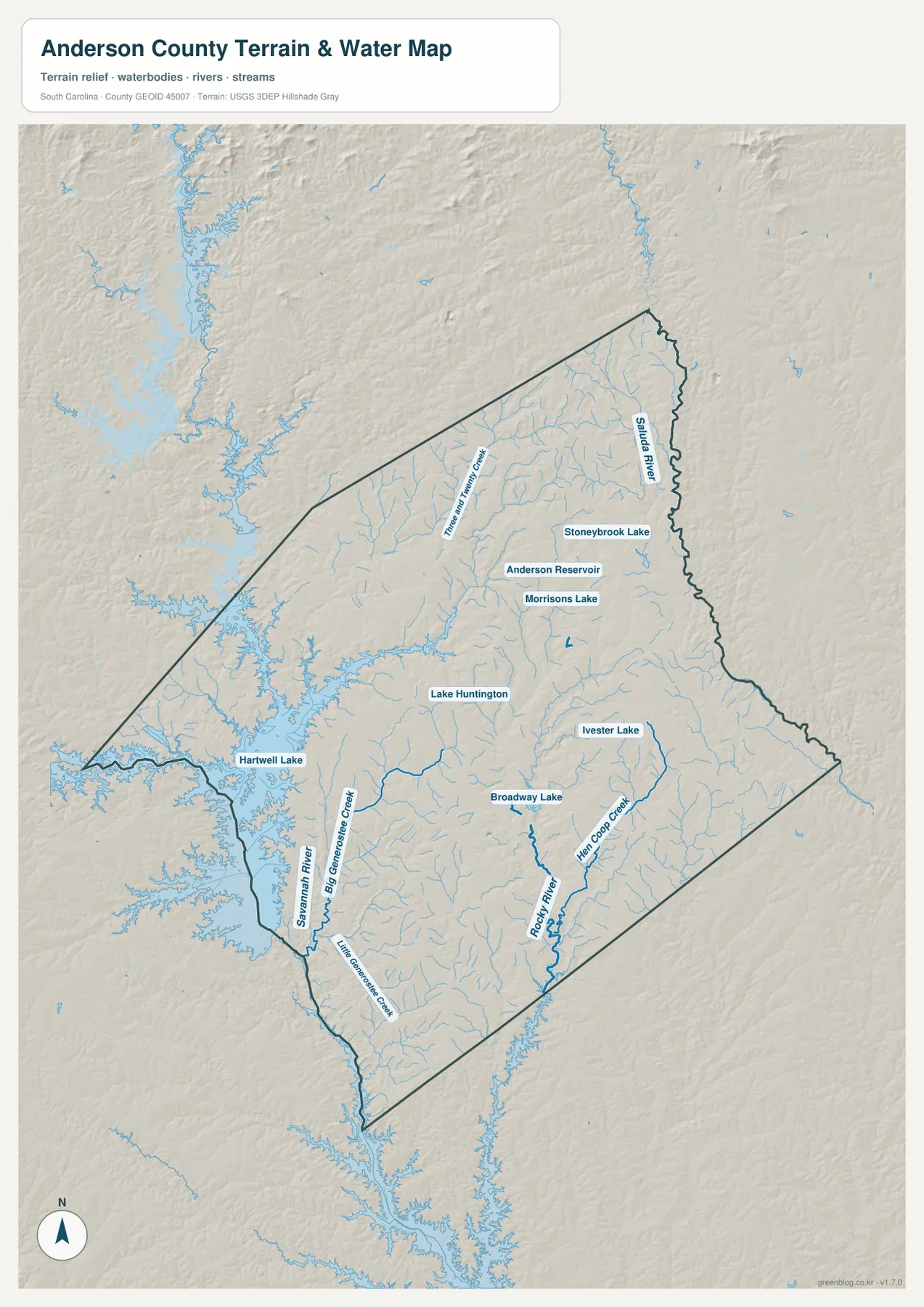
The shaded background suggests rolling relief rather than a perfectly flat surface, but the file does not print exact elevation values or summit heights. For that reason, it is better to use the relief as a visual backdrop for the drainage lines instead of assigning specific elevations to places. The most defensible observations are visible ones: Hartwell’s indented shoreline, the long Saluda River edge, the group of smaller lakes east and south of Anderson, and creek lines that branch through the interior.
Reading the two water edges changes how the county’s towns fit together
Once Hartwell Lake and the Saluda River are used as opposite reference points, the place map becomes easier to interpret. Pendleton and Centerville sit closer to the lake side of the county, while Belton and Williamston are in the eastern half. Anderson remains between those outer references rather than at an extreme edge. Farther south, Starr and Iva occupy the interior above the narrowing southern end, and Honea Path lies toward the southeast. This west-to-east water framework makes the road map feel much less abstract.
It also explains why one map is not enough for every task. A county profile or travel overview may need the general map because it preserves the numbered routes and smaller place labels. A presentation about settlement distribution can use the ranked city map because six names stand out immediately. A geography lesson or environmental overview is better served by the terrain-and-water file, where Hartwell Lake, the Saluda River, Anderson Reservoir, Broadway Lake, Rocky River, and the named creeks are not competing with a dense road network.
Choose the map by the question you need to answer
For basic orientation, start with the county map and find Anderson first. From there, follow the numbered routes toward Pendleton in the northwest, Williamston and Piedmont in the northeast, Belton in the southeast, or Starr and Iva to the south. If the road lines become distracting, switch to the city map and use the six numbered markers. When a lake, river, creek, or reservoir is the subject, the water map is the clearer choice because it gives those names enough space to remain readable.
Keeping the three views separate is especially helpful for printing. Small stream labels can disappear when road and city information are crowded onto the same page, and a ranked city comparison does not need every creek name. The files in this package preserve the same county but separate the visual priorities, so you can choose the version that matches a report, handout, classroom activity, or local reference without editing one overloaded image.
County reference facts that add context to the map
| State | South Carolina |
|---|---|
| County | Anderson County |
| County seat | Anderson |
| Founded | 1826 |
| Existing SCAC reference population | 203,718 |
| Land area | 718 sq mi |
| Broad regional context in the supplied material | Piedmont |
| Ranked city-map labels | Anderson, Belton, Williamston, Honea Path, Pendleton, Pelzer |
The administrative and size figures above are retained from the SCAC-based reference material supplied with this rewrite package. They are background facts rather than measurements taken from the images. On the maps themselves, county scale is easier to understand through the separation between Anderson and the outer place labels, the branching Hartwell shoreline on the west, the long Saluda River edge on the east, and the distance between Pendleton, Honea Path, and the southern communities. Those visual relationships add meaning that a land-area number alone cannot provide.
Details worth checking when you zoom into Anderson County
- Central Anderson: several numbered routes sit close together, making the city the easiest road-network reference.
- Northeast: Williamston, Piedmont, Powdersville, and Pelzer create a denser group of named places than the southern tip.
- Southeast: Belton and Honea Path help trace the settlement pattern away from Anderson toward the lower eastern side.
- West: Pendleton and Centerville sit on the Hartwell side, where the shoreline is much more irregular than the county’s straighter southeastern edge.
- Interior waters: Anderson Reservoir, Morrisons Lake, Lake Huntington, Ivester Lake, and Broadway Lake provide smaller water references between the two major boundary waters.
- Southern drainage: Rocky River, Hen Coop Creek, Big Generostee Creek, Little Generostee Creek, and the Savannah River labels make the lower half of the water map especially detailed.
These are county-specific details from the supplied Anderson maps, not generic map-use language. The combination of a strong central city, a western reservoir shoreline, an eastern river boundary, six ranked place labels, and numerous named internal waters gives Anderson County a recognizable visual pattern. If you compare this map with another South Carolina county, those are the features most likely to keep the two from being confused.
Frequently Asked Questions
Where are Hartwell Lake and the Saluda River on the Anderson County map?
Hartwell Lake dominates the western side of the terrain-and-water map with a highly indented shoreline. The Saluda River is labeled along the eastern boundary. Using those two features as opposite anchors makes it easier to locate Anderson Reservoir, Broadway Lake, Rocky River, and the smaller creeks between them.
Which places are included on the ranked city map?
The city map ranks Anderson first, followed by Belton, Williamston, Honea Path, Pendleton, and Pelzer. The markers also show the spatial pattern: Pendleton is toward the northwest, Pelzer near the northeast, and Belton, Williamston, and Honea Path across the eastern half.
Can I download a larger Anderson County map for printing?
Yes. The images in the article are web previews, while the ZIP contains separate 3638 × 2572-pixel A3 JPG files for the county map, city map, and terrain-and-water map. The JPG versions are the better choice when you need a larger print, want to enlarge small labels, or need a high-resolution image for a document.
Map File Information
The download ZIP contains high-resolution A3 JPG versions of the county map, ranked city map, and terrain-and-water map shown on this page. Each is a separate image, making it easy to print one map, insert it into a document, or compare Anderson County with another county at the same page size.
- Included Files: Three high-resolution A3 JPG maps: county map, ranked city map, and terrain-and-water map
- File Type: High-resolution A3 JPG files in one ZIP archive
- Intended Use: Printing, education, presentations, and map-based projects
Related Maps
Sources and Reference Data
- South Carolina Association of Counties – County Information: county seat, area, and existing county reference figures
- SCAC County Directory Pages: county directory and founding-year reference
- U.S. Census Bureau TIGER/Line Shapefiles: county boundary and road reference data
- USGS National Hydrography: river, creek, lake, and reservoir reference data
- USGS 3D Elevation Program: elevation and shaded-relief reference data
- South Carolina Geological Survey: Piedmont and regional physical-geography references
Green Map creates custom-edited map images using open geographic data sources such as geoBoundaries, Natural Earth, OpenStreetMap, and government open data.
These maps are edited visual materials, not raw data files, and are provided for education, documents, presentations, and graphic reference.