This Charleston County Map page is built around the coastal shape that makes the county immediately recognizable. Charleston and North Charleston occupy the southwestern urban side of the map, while Mount Pleasant and Awendaw extend the county far to the northeast. South of Charleston, James Island and Folly Beach lead toward the ocean, and farther southwest the boundary reaches Kiawah Island and Seabrook Island. Isle of Palms and Sullivan’s Island sit on the eastern coast near Mount Pleasant. The supplied maps show the county boundary and major numbered roads, the distribution of six highlighted places, and the network of rivers, bays, sounds, and coastal water. The matching original A3 high-resolution JPG files are also available together in a ZIP download on this page.
Charleston County is easier to read when land and water are considered together. The county does not form one compact block around Charleston. North Charleston reaches northwest from the central urban area, Ravenel, Hollywood, and Meggett spread across the west and southwest, and a long northeastern section follows the coast from Mount Pleasant toward Awendaw. The southern islands create another set of separate reference points. A reader who looks only for Charleston may miss how far the county stretches in several directions and how often the boundary bends around tidal and coastal water.
The terrain-and-water map makes that pattern especially clear. The Cooper and Ashley rivers are prominent near Charleston, and the Wando River runs through the Mount Pleasant side of the county. Bulls Bay and Sewee Bay occupy a large part of the northeastern coast. Farther south and southwest, Clark Sound, the Wadmalaw River, the North and South Edisto rivers, and St Helena Sound add more water references. These names are not included simply as background decoration; they explain why the county’s road network, settlements, islands, and boundary look so different from a simple inland county.
Table of Contents
Following the county from Charleston to Awendaw
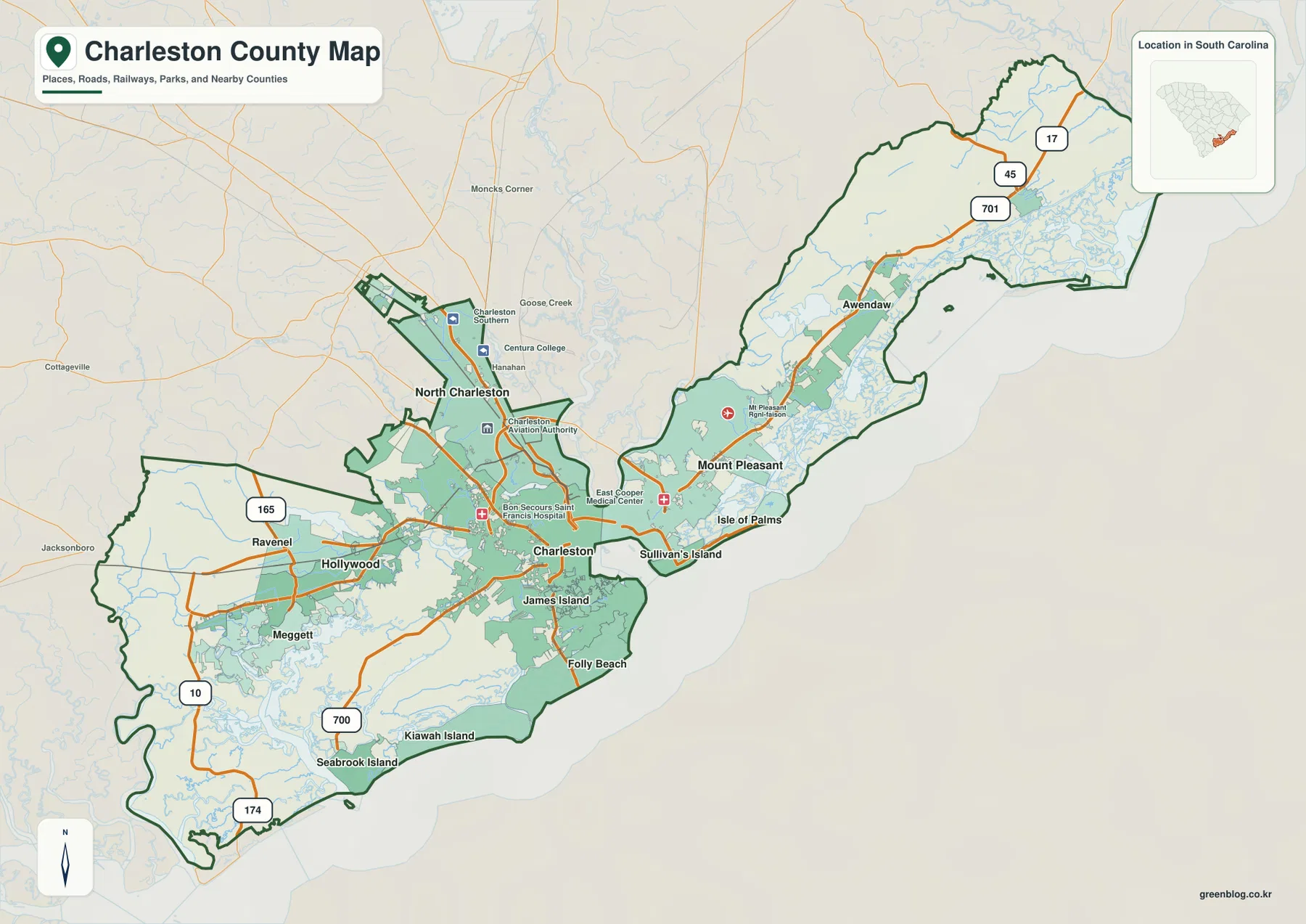
The county overview gives Charleston and Mount Pleasant the strongest visual roles. Charleston sits near the southwestern side of the main coastal urban area, while Mount Pleasant is labeled to the east across a water-separated part of the county. North Charleston spreads northwest of Charleston, and the map also shows surrounding reference names such as Goose Creek and Moncks Corner outside or near the county boundary. Keeping the dark county outline in view is important because the surrounding urban region extends beyond Charleston County itself.
The northeastern section is long and comparatively narrow. Route 17 is the clearest road reference as the county continues from the Mount Pleasant side toward Awendaw. Route 45 and U.S. 701 appear farther northeast. The boundary becomes highly irregular near the coast, where many small waterways are drawn inside and beside the county. Rather than reading this area as a straight highway corridor, it is more accurate to notice how the road and the county outline repeatedly approach a broad field of marshes, channels, and coastal water.
The western half has a different pattern. Ravenel is marked near Route 165, with Hollywood and Meggett positioned farther south and east. Roads 700 and 174 provide references toward the Kiawah Island and Seabrook Island side of the county. The map is not intended to replace a street-level navigation product, but these numbered routes are useful for understanding which communities belong to the western mainland and which lie farther out on the coastal islands.
Island names are essential to the overall shape. James Island appears just south of Charleston, with Folly Beach farther toward the Atlantic side. Sullivan’s Island and Isle of Palms lie east of Mount Pleasant. Kiawah Island and Seabrook Island occupy the far southwestern coastal end. When these places are read together, the county no longer looks like a single urban area around Charleston; it becomes a long coastal jurisdiction made up of mainland sections, islands, and narrow connections between them.
Several labels outside the boundary help with regional orientation. Cottageville and Jacksonboro appear to the west, while Moncks Corner and Goose Creek are visible to the northwest. These are useful reference points, but the heavy county line should remain the primary guide. A place name near the boundary does not automatically mean it lies inside Charleston County. The overview works best when the boundary, major roads, and surrounding names are read together rather than separately.
Six highlighted places show a split coastal settlement pattern
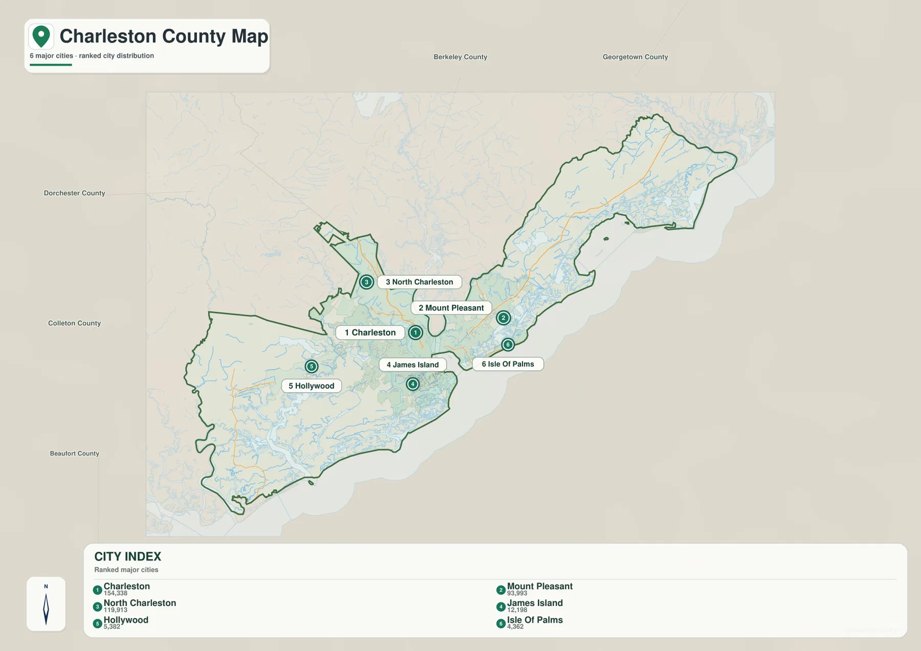
The city-distribution map removes much of the road detail and emphasizes six named places in its City Index: Charleston, Mount Pleasant, North Charleston, James Island, Hollywood, and Isle of Palms. The value of the index on this page is primarily geographic. It shows that the highlighted places are not arranged around one center. Charleston, Mount Pleasant, and North Charleston form a relatively close urban triangle, while James Island and Isle of Palms sit on separate coastal or island sections and Hollywood stands apart to the west.
Charleston is positioned near the central southwestern coast. Mount Pleasant is clearly east of it, and North Charleston is northwest. Those three labels make a useful starting frame for reading the rest of the county. James Island then appears directly south of Charleston, while Isle of Palms sits east of Mount Pleasant along the ocean side. Hollywood is the western outlier among the six highlighted names. This distribution makes it difficult to describe Charleston County as a simple city-and-suburb pattern because water separates several of the major reference places.
The county names around the edge of the map add a second layer of context. Berkeley County and Georgetown County are shown to the north and northeast, Dorchester County and Colleton County to the west, and Beaufort County farther southwest. These labels help place the long Charleston County outline within coastal South Carolina. They also explain why the northeastern end near Awendaw and the southwestern end near the islands feel far removed from one another even though they belong to the same county.
The six-place index should not be treated as a complete municipal inventory or as a substitute for current official population rankings. It is a map-specific selection of prominent reference places. For this article, the useful information is the relative position of those labels and how they relate to the county boundary. Readers who need the legal limits of individual municipalities or the latest demographic figures should consult the appropriate official datasets separately.
Rivers, bays, and sounds explain the county’s irregular coastline
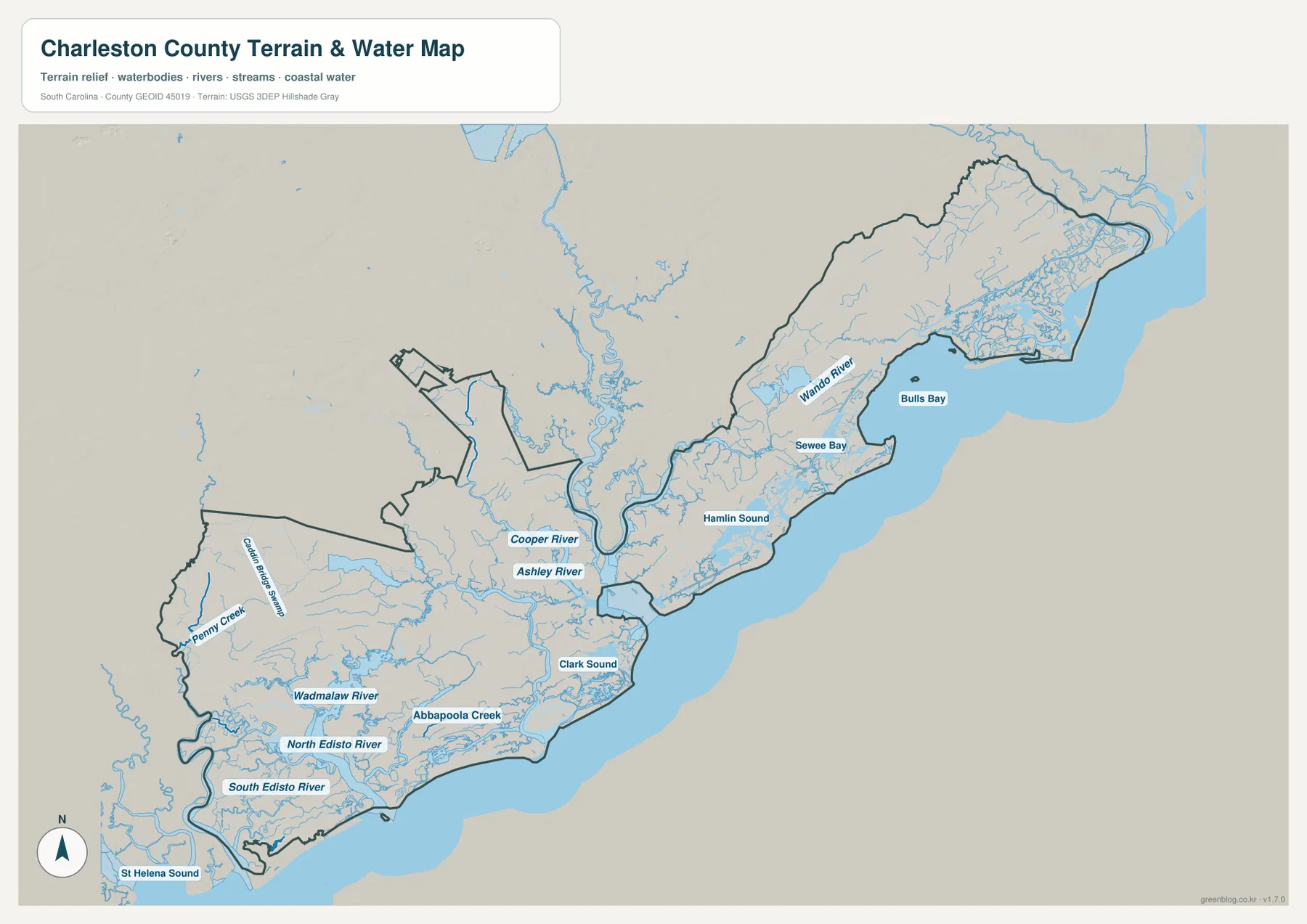
The terrain-and-water view is the best map for understanding why the boundary is so irregular. Near Charleston, the Cooper River and Ashley River are both clearly labeled, and the Wando River becomes a major reference on the Mount Pleasant side. These waterways divide the central part of the county into distinct pieces of land. When the same area is viewed only on the road map, the urban labels can appear close together; the water map shows the physical separation that lies between them.
The northeastern coast is dominated by Bulls Bay, with Sewee Bay nearby. The Wando River runs toward this broader coastal area, while numerous smaller channels fill the low-lying edge of the county. Awendaw is not labeled on the water map itself, but the position can be related back to the county overview. Comparing the two maps helps show why the northeastern section follows a long coastal strip rather than a simple inland boundary.
South of the central urban area, Hamlin Sound and Clark Sound are labeled as separate water spaces. They help explain the gaps between the mainland and the island or coastal sections shown on the overview. Farther southwest, the Wadmalaw River and Abbapoola Creek appear among a dense network of smaller channels. The map then adds the North Edisto River and South Edisto River near the southwestern edge, with St Helena Sound shown beyond the county’s lower coastal side.
Penny Creek is labeled near the western boundary, and many unnamed tributaries and channels are visible throughout the county. This density is useful context even where the map does not print a name beside every water feature. The goal is not to catalog every creek; it is to show that the county’s shape is strongly influenced by water at several scales, from major rivers and bays to the small channels that surround the islands and low coastal land.
The shaded terrain background is subtle. It does not show dramatic mountain relief, and it should not be used to read precise elevation values. Instead, the shading provides a base for the water network and helps distinguish broad land surfaces from the river and coastal channels. Flood-risk analysis, marine navigation, parcel boundaries, and engineering work require dedicated authoritative products. This map is best used as a geographic reference for the position of major waterways and coastal landforms.
Choosing the map that fits a road, city, or water question
The three supplied maps answer different practical questions without repeating the same information at the same level of detail. The county overview is the fastest choice for major roads, place names, islands, and the full boundary. The city-distribution map is cleaner when the goal is to compare the location of the six highlighted places. The terrain-and-water map is the strongest reference for the Cooper, Ashley, and Wando rivers, the large northeastern bays, and the water network around the southern and southwestern islands.
A useful reading sequence is to begin with Charleston, Mount Pleasant, and North Charleston on the county overview, then trace Route 17 toward Awendaw or the western routes toward Ravenel and the southern islands. After that, the city map clarifies which highlighted places cluster near the central coast and which are separated by distance or water. The water map can then explain the physical divisions that are only partly visible on the road layer. This sequence is especially helpful for readers unfamiliar with the county’s long coastal outline.
- County overview: best for Charleston, Mount Pleasant, North Charleston, major numbered roads, island names, and the county boundary.
- City distribution: best for comparing Charleston, Mount Pleasant, North Charleston, James Island, Hollywood, and Isle of Palms without heavy road detail.
- Terrain and water: best for the Cooper, Ashley, and Wando rivers, Bulls Bay, Sewee Bay, the Wadmalaw River, and the southwestern coastal water network.
Frequently Asked Questions
How are Charleston and Mount Pleasant positioned on the county map?
Charleston is shown on the southwestern side of the central coastal urban area, while Mount Pleasant is east of it. The terrain-and-water map makes the separation easier to understand because the Cooper River and nearby waterways divide the two sides of the county.
Are Kiawah Island and Isle of Palms on the same side of Charleston County?
No. Isle of Palms is east of Mount Pleasant along the ocean side, while Kiawah Island is far to the southwest of Charleston. Seabrook Island is near Kiawah Island, and James Island and Folly Beach occupy a more central southern position closer to Charleston.
Can the terrain and water map be used for flood or navigation decisions?
No. It is a geographic reference for the location of rivers, bays, sounds, creeks, and coastal water. Flood-risk decisions, water depth, navigation routes, parcel boundaries, and precise elevation work require dedicated authoritative datasets and specialized maps.
Map File Information
Download the same original A3 high-resolution JPG files used for the Charleston County maps on this page in one ZIP archive.
- Included Files: county overview, city distribution map, terrain and water map
- Printable Size: 3638×2572 px each
- File Type: JPG
Related Maps
Sources and Reference Data
For county administration and general county information, see the South Carolina Association of Counties County Information. County boundary data can be checked through the U.S. Census Bureau TIGER/Line Shapefiles. River, creek, and hydrography references are available from USGS National Hydrography, while statewide terrain and geology background can be reviewed through the South Carolina Geological Survey.
Green Map creates custom-edited map images using open geographic data sources such as geoBoundaries, Natural Earth, OpenStreetMap, and government open data.
These maps are edited visual materials, not raw data files, and are provided for education, documents, presentations, and graphic reference.