Georgetown County, South Carolina occupies a distinctive stretch of the state’s Atlantic coast where large rivers, tidal waterways, inland roads, and coastal communities meet. Georgetown sits near Winyah Bay in the southeastern part of the county, Andrews lies well to the west, and Pawleys Island is positioned along the northeastern coast. The maps on this page are designed to make those relationships easy to see: one emphasizes the county boundary and main roads, another focuses on the three principal municipal references, and the water map brings the river-and-bay system forward. Lightweight WEBP previews appear in the article, while the downloadable ZIP contains high-resolution A3 JPG files.
The county’s shape is not defined by roads alone. Its northern and southern edges follow major river systems for long stretches, while the eastern side opens to the Atlantic Ocean and includes a much more intricate shoreline. That combination gives Georgetown County a map pattern that is easy to recognize once Winyah Bay, the Waccamaw River, the Great Pee Dee River, and the Santee system are added to the boundary. The same geography also helps explain why Georgetown functions as a natural reference point for both the inland and coastal parts of the county.
These files are best used as county-scale reference maps rather than turn-by-turn navigation products. They show the broad road network, selected place names, direct city connections, rivers, bays, creeks, and coastal water in a clean format. They do not attempt to include every local street, every community, property lines, flood zones, or marine navigation details.
Table of Contents
A Coastal County With a Long Inland Reach
Georgetown County lies on the eastern side of South Carolina. Horry and Marion counties are to the north, Williamsburg County is to the west, and Berkeley and Charleston counties lie to the south; the Atlantic Ocean forms the broad eastern edge. This position creates a county that stretches from inland communities and forested river country to tidal marshes, barrier-coast settlements, and open ocean. On a statewide map, it occupies a mid-coast location between the Myrtle Beach area to the north and the Charleston region to the south.
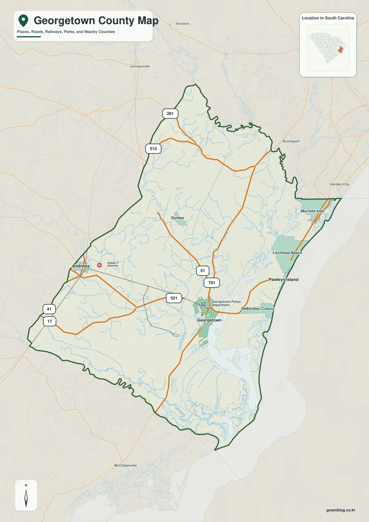
The county overview makes the contrast between the western and eastern sides especially clear. Andrews appears near the western edge, while Georgetown is much farther southeast at the road-and-water junction near Winyah Bay. Along the northeastern coast, the map labels Pawleys Island, Litchfield Beach, and Murrells Inlet, giving the reader several recognizable coastal reference points. The county boundary then continues south around a dense network of marsh channels and river mouths before returning inland.
The northern and southern boundaries are noticeably irregular because river corridors play such a large role in the county’s geography. The Great Pee Dee system defines much of the northern side, and the Santee system is a major feature along the south. Instead of treating those curves as incidental details, it is useful to see them as part of the county’s identity: administrative lines and natural waterways are closely connected here.
The small South Carolina locator in the map’s upper corner is helpful when the county outline is viewed by itself. Georgetown County is neither at the extreme northeastern corner of the state nor directly beside Charleston’s urban core. It occupies the coast between those better-known regions, with a large inland area behind the beaches and estuaries. That broader position is important because the county includes far more than its oceanfront communities.
Roads Converge on Georgetown While Settlements Spread West and Northeast
The road pattern gives Georgetown a strong visual role as the county hub. US 17 passes through the coastal side of the county and Georgetown, while US 521 approaches from the west. US 701 and SC 51 connect the Georgetown area with communities farther north, and the map also labels SC 41, SC 261, and SC 513 in the western and northwestern parts of the county. These routes make it possible to understand the county at a glance without turning the image into a full highway atlas.
Andrews sits in a very different setting from Georgetown. It is inland and close to the western side of the county, where US 521 and SC 41 help organize the local road network. Pawleys Island, by contrast, is northeast of Georgetown along the coastal corridor. Litchfield Beach and Murrells Inlet appear in the same general direction on the overview map, reinforcing the fact that much of the county’s better-known beach development is concentrated away from the western interior.
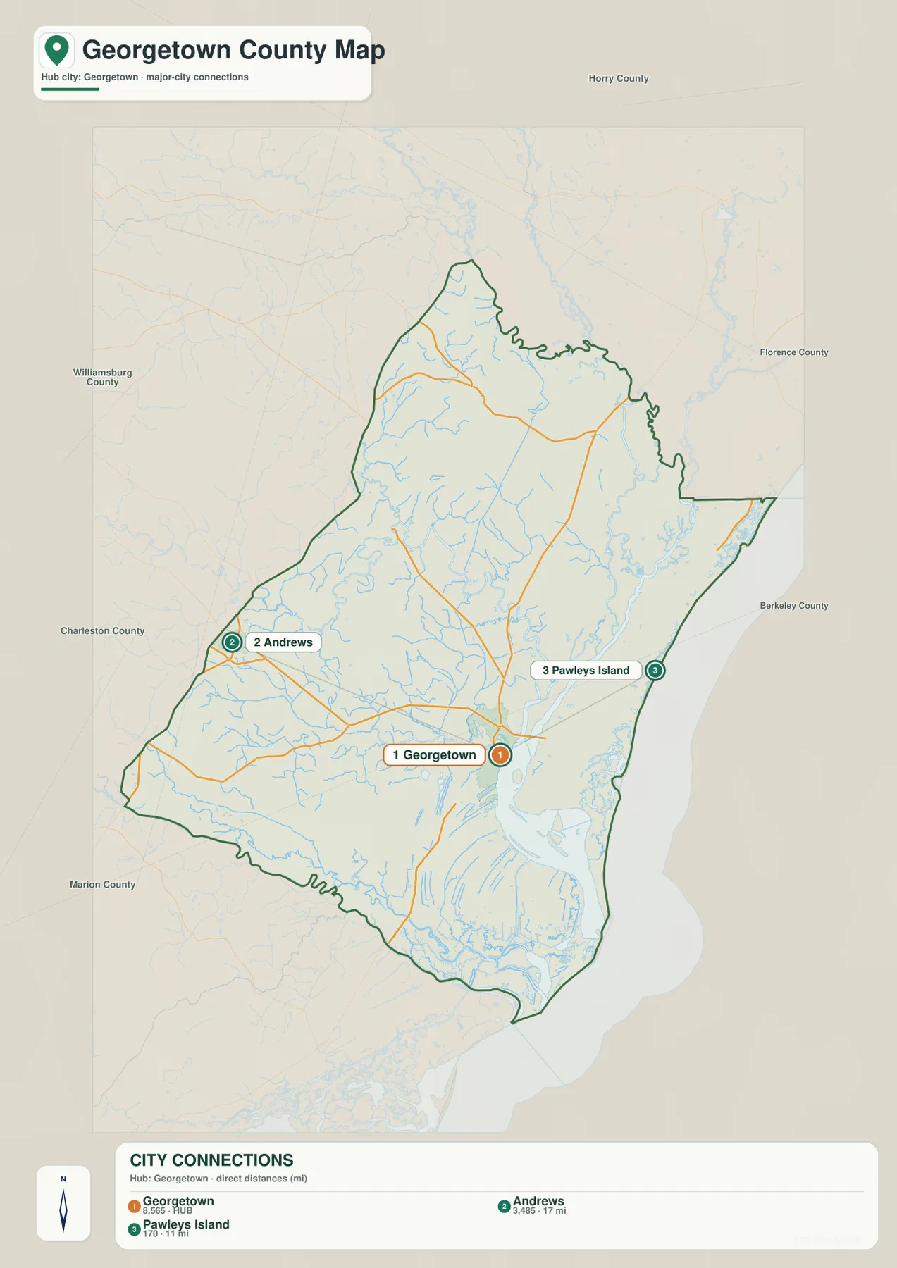
The city connection map simplifies that settlement pattern by highlighting Georgetown, Andrews, and Pawleys Island. It shows Andrews about 17 miles from Georgetown and Pawleys Island about 11 miles away as direct distances. Those values are useful for comparing relative spacing, but they should not be read as driving mileage. Actual road distance depends on the route taken, bridge crossings, and the local street network.
The same map places surrounding county names outside the Georgetown County boundary, which helps orient the reader without filling the interior with extra labels. Horry is to the north, Williamsburg lies westward, and Berkeley and Charleston are on the southern side. Once those directions are established, the locations of the three municipalities make more sense: Georgetown is positioned toward the coast and bay, Andrews anchors the western side, and Pawleys Island marks the northeastern shoreline.
This stripped-down city view is particularly useful when the purpose is to explain settlement geography rather than individual streets. A classroom slide, county profile, or travel-orientation page can show the three places without requiring the audience to sort through dozens of minor road names. The underlying rivers and highways remain visible enough to provide context, but the municipal relationship stays central.
Winyah Bay Links the Waccamaw and Great Pee Dee to the Atlantic
Water is the strongest physical feature on the Georgetown County maps. Near Georgetown, the Waccamaw River and Great Pee Dee River approach Winyah Bay, creating a broad estuarine setting before the water reaches the Atlantic. The county’s official resilience planning documents describe Winyah Bay as the mouth of the larger Pee Dee River watershed, which is why the river network occupies so much of the eastern and central map area.
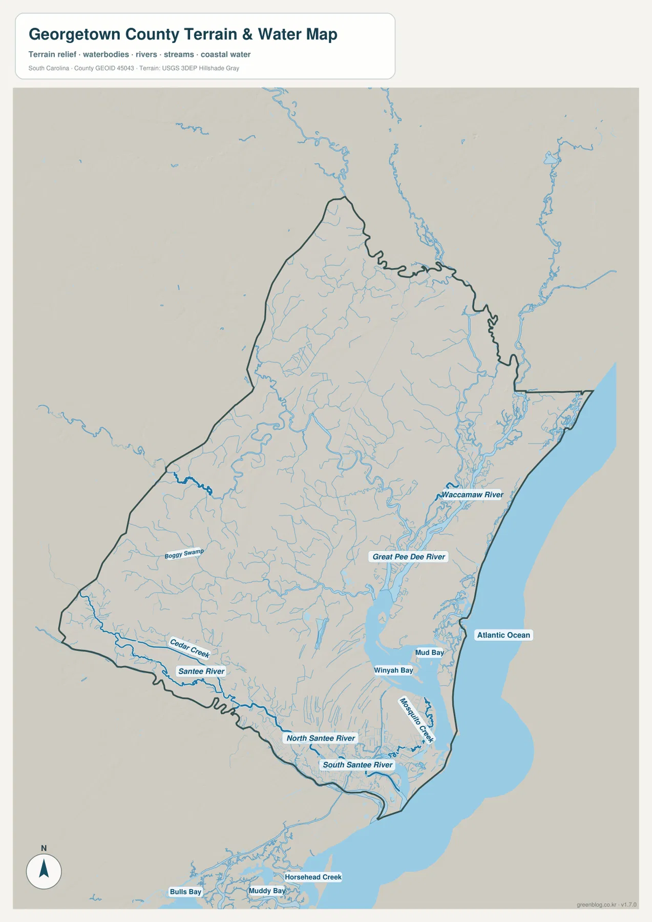
The map’s southern half shows another major system. The Santee River reaches the lower county area and divides into North Santee and South Santee channels near the coast. Between and around those channels, the map shows a dense mesh of small waterways, marsh edges, and tidal features. Cedar Creek, Boggy Swamp, Mosquito Creek, and Mud Bay are among the smaller named features that make the southern boundary look far more complex than a simple line on a political map.
Winyah Bay is the easiest landmark for connecting the water map back to the city map. Georgetown sits close to the bay, while the Waccamaw enters from the north and the Great Pee Dee approaches from the northwest. The Atlantic Ocean is immediately to the east. This arrangement explains why Georgetown can be located so quickly when the waterways are visible: it is near the meeting point of several large hydrologic features rather than on an undifferentiated stretch of coastline.
The county is also unusually low and flat. Georgetown County hazard-mitigation material notes that about 90 percent of the county is below 40 feet above mean sea level. The water map does not provide exact elevation readings, but the subdued relief and widespread drainage network are consistent with that low Coastal Plain setting. For exact heights, a dedicated elevation product such as the USGS 3D Elevation Program is a better source.
It is equally important to recognize what this map is not. It is not a flood-risk map, a nautical chart, or a parcel survey. Waterways are presented to explain county-scale geography, not to establish safe boating channels, legal water boundaries, or site-specific hazard levels. Anyone making navigation, engineering, emergency, or property decisions should use the appropriate current official dataset for that purpose.
Reading the Boundary, Settlement, and Water Patterns Together
Each map becomes more useful when it is compared with the others. Start with the county overview to find Georgetown and the major highways. Then look at the city connection view to see how Andrews and Pawleys Island sit on opposite sides of the county relative to Georgetown. Finally, use the water view to understand why the eastern and southern parts of the boundary contain so many curves, channels, and open-water areas.
For example, US 17 is easy to identify on the county map as a principal coastal route through Georgetown. When the water layer is viewed next, the road’s position can be compared with Winyah Bay and the major river mouths. That simple comparison helps a reader understand why the road network and settlement pattern concentrate in certain corridors while large sections of the county remain dominated by rivers, marshes, and low-lying land.
The western side tells a different story. Andrews is connected to Georgetown by the inland road network, but it is much farther from the bay and ocean. The city map makes that separation immediately visible, while the county map provides the road context. This distinction matters when describing Georgetown County because a beach-focused view alone would miss a large inland portion of the county and its connection to Williamsburg County and the upper river landscape.
The northeastern shoreline also has its own pattern. Pawleys Island is closer to Georgetown than Andrews in the direct-distance comparison, and the overview places Litchfield Beach and Murrells Inlet in the same coastal direction. Those references help distinguish the Waccamaw Neck side of the county from the city of Georgetown and from the western interior. A single generalized county outline would not show that contrast nearly as clearly.
Practical Uses for the A3 Map Files
The on-page WEBP previews are convenient for browsing, but the A3 JPG files are the better choice when small labels and waterways need to remain legible in a document or printout. Their vertical layout works well for reports, classroom handouts, presentations, and county-by-county comparison projects. Because the three files use the same county extent, a reader can move from roads to settlements to water features without having to reorient the entire page.
Choose the file that matches the question you are trying to answer. A boundary-and-road explanation benefits from the general county view; a short discussion of where the municipalities sit is clearer with the city connection view; and a geography section about rivers, estuaries, or the Santee system is easier to follow with the water-focused map. Keeping the purpose narrow usually produces a cleaner page than placing every available label on one image.
For presentations, it can also be effective to use the maps in sequence. Begin with the county outline and roads so the audience knows where Georgetown County is, follow with the city relationship, and then introduce the river system. If the topic is environmental geography, reverse the order and begin with Winyah Bay and the rivers before adding settlements and highways. The maps are flexible enough to support either approach without changing the underlying geographic reference.
Remember that these are reference graphics, not authoritative substitutes for live transportation, survey, or hazard systems. Roads can change, local street details are intentionally reduced, and the water map does not carry depth or flood-probability information. The strongest use is to explain where places and large physical features are in relation to one another at the county scale.
Frequently Asked Questions
Are the 17-mile and 11-mile city connections driving distances?
No. The city map uses direct distance from Georgetown to compare the relative spacing of Andrews and Pawleys Island. Driving mileage and travel time depend on the road route, so a current navigation service should be used when planning an actual trip.
Which waterways are most important for understanding Georgetown County on this map?
The clearest county-scale features are the Waccamaw River and Great Pee Dee River leading toward Winyah Bay, plus the Santee River system along the southern side. The water map also labels smaller creeks, swamps, bays, and the Atlantic Ocean so the more detailed coastal pattern is easier to follow.
What is included in the downloadable Georgetown County map ZIP?
The archive contains three A3 JPG files covering the county boundary and roads, municipal connections, and terrain and water. The article uses lighter WEBP previews of the same map topics for faster on-page viewing.
Map File Information
The ZIP contains three high-resolution A3 JPG files for Georgetown County: the county-and-road map, the city connection map, and the terrain-and-water map. Use the WEBP images in the article for quick viewing and the JPG files when you need a larger printable version.
- Included Files: 3 high-resolution A3 JPG map files shown in this article
- File Type: JPG files in a ZIP archive
- Intended Use: Printing, education, presentations, and map-based projects
Related Maps
Sources and Reference Data
- U.S. Census Bureau TIGER/Line: county boundary and administrative geography reference
- South Carolina Department of Transportation – Georgetown County Map: US and state highway reference
- Georgetown County Resiliency Element: municipal, watershed, and coastal context
- USGS National Hydrography: river and waterbody reference data
- South Carolina DNR – Great Pee Dee River: lower Great Pee Dee and Winyah Bay context
- Georgetown County Hazard Mitigation Plan: low terrain and major river-system context
Green Map creates custom-edited map images using open geographic data sources such as geoBoundaries, Natural Earth, OpenStreetMap, and government open data.
These maps are edited visual materials, not raw data files, and are provided for education, documents, presentations, and graphic reference.