The Richland County South Carolina Map on this page is built around the county’s most useful visual relationships: Columbia at the center of a dense interstate network, Blythewood to the north, Irmo to the west, Eastover to the southeast, and the Broad-Congaree river system along the western side. The article includes browser-friendly WebP previews and a ZIP download with the matching high-resolution A3 JPG files for printing, reports, or classroom use.
The general county map combines roads, communities, parks, and nearby context. The city map simplifies that picture into six ranked places, while the terrain-and-water map removes most road detail so the Broad River, Congaree River, creeks, lakes, and ponds are easier to follow. Reading the three views together is especially useful in Richland County because the compact Columbia urban area contrasts sharply with the more open northern and southeastern sections.
Table of Contents
Columbia sits at the meeting point of I-20, I-26, and I-77
The road map makes Columbia the obvious starting point. I-20 runs across the middle of the county, I-26 approaches from the west, and I-77 provides a major north-south reference east and north of central Columbia. Once those three interstate corridors are located, nearby places such as Forest Acres, Dentsville, St. Andrews, and Irmo become much easier to place.
Several numbered highways add a second layer of orientation. US 1, US 21, and US 321 appear around the central and northern part of the county, while 176 and 215 help define the western side. Farther southeast, 378 and 76 cross toward Eastover, and 769, 48, and 601 are shown through the southern and southeastern section. The difference between the dense central road network and the longer rural corridors farther south is one of the clearest features of the map.
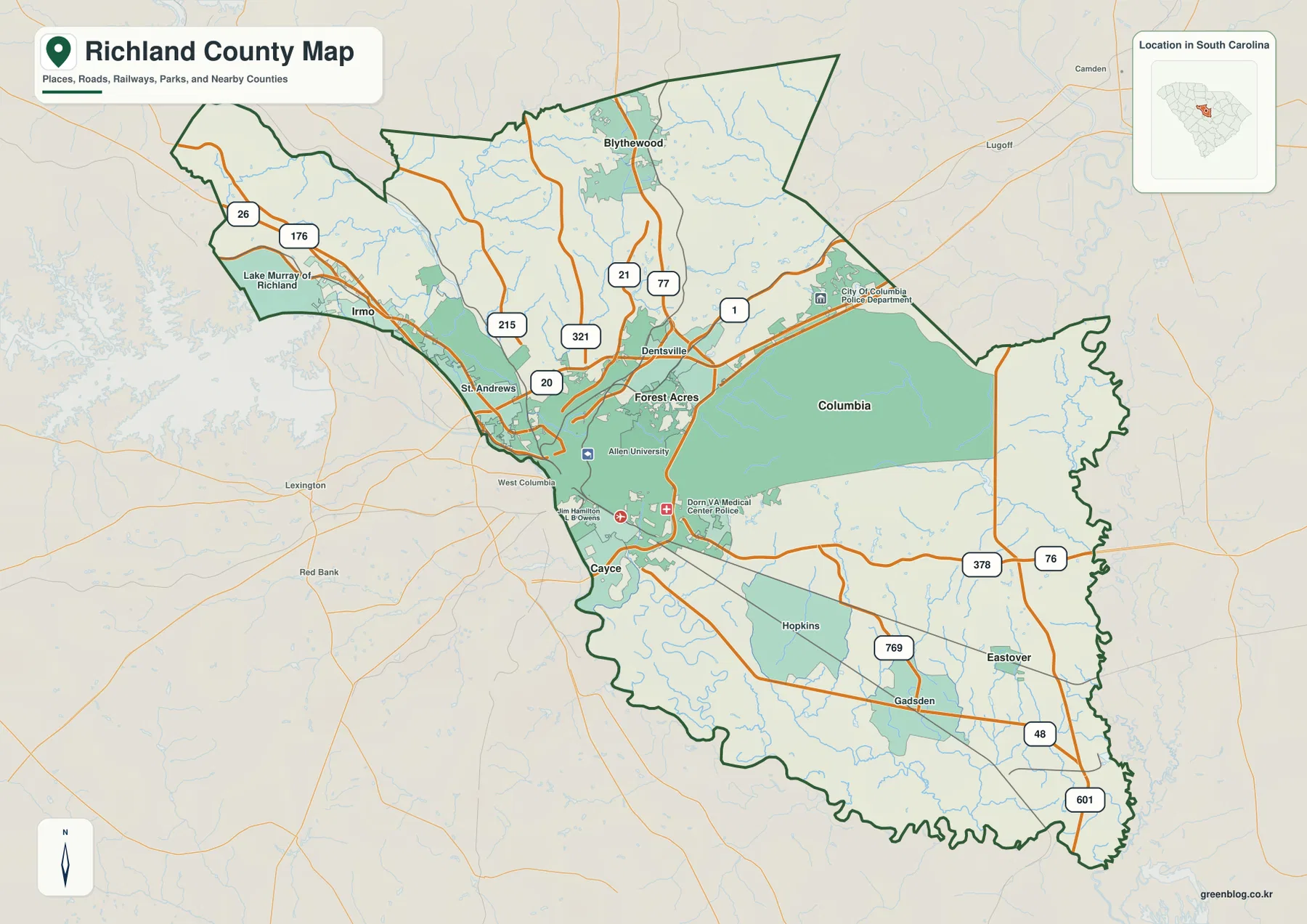
Blythewood is clearly separated from the Columbia core in the north. On the west, Irmo and the Lake Murray side form a distinct extension of the county, while St. Andrews sits much closer to Columbia. South of the central city, Cayce appears near the boundary and the map then opens into a much larger area containing Hopkins, Gadsden, and Eastover. This north-central-southeast progression is more informative than treating Richland County as if it were only the Columbia metropolitan area.
The six-city view spreads from Irmo and Blythewood to Eastover
The city map ranks Columbia first, Forest Acres second, Irmo third, Blythewood fourth, Arcadia Lakes fifth, and Eastover sixth. The numbers are index labels rather than travel distances. Columbia, Forest Acres, and Arcadia Lakes occupy the central cluster; Irmo is west of that group, Blythewood is far to the north, and Eastover is isolated toward the southeast.
That arrangement shows why the city map is useful before looking at road detail. A reader searching for Eastover can immediately see that it lies far from the central cluster, then switch to the county map to locate 378, 76, 48, and 601. The same approach works for Blythewood and Irmo. Their broad direction is obvious on the simplified city map, while the county map adds the surrounding highways and smaller communities.
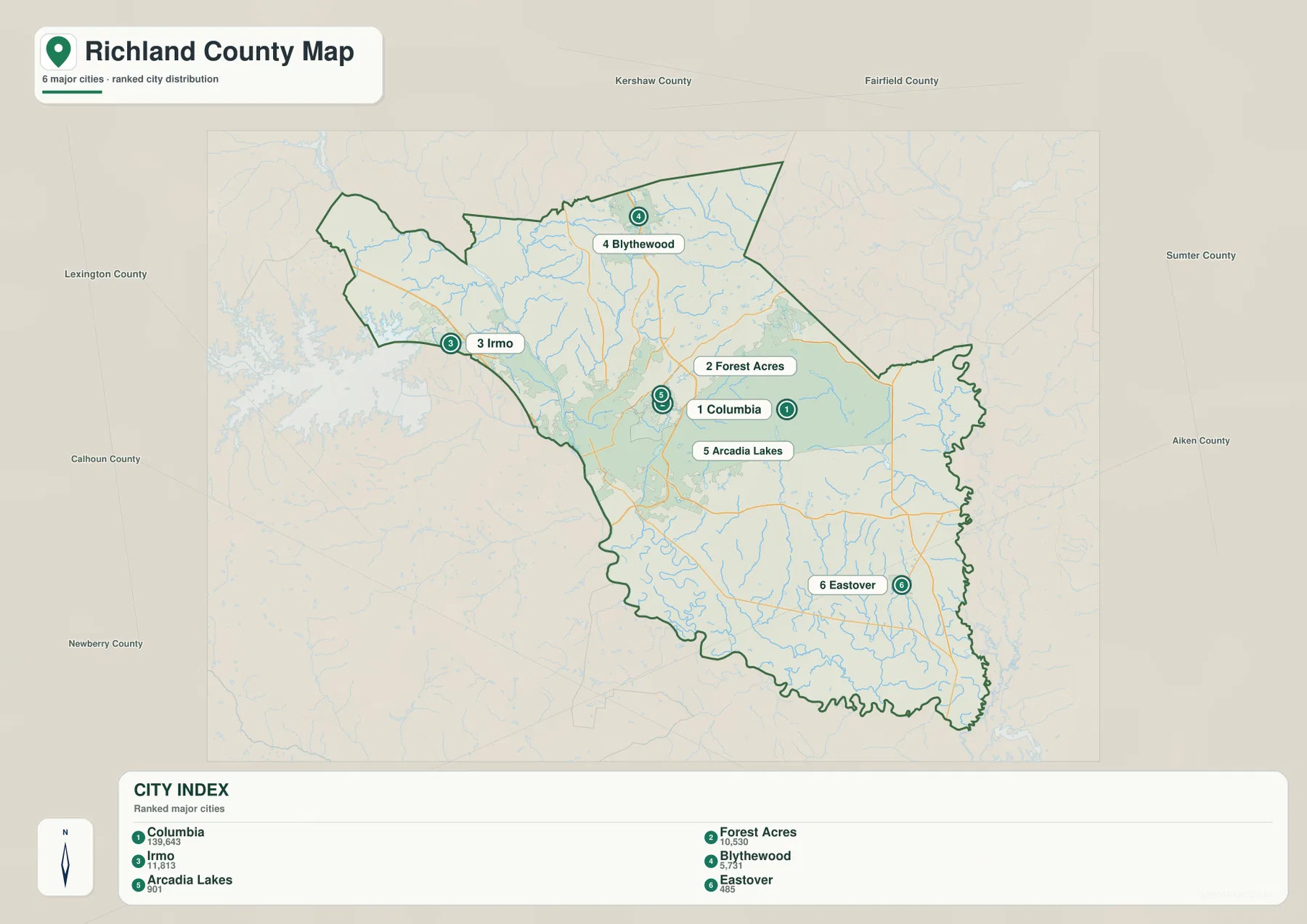
The surrounding county labels provide additional orientation without turning the map into a route planner. Lexington County is shown to the west, Fairfield and Kershaw are to the north, and Sumter County appears on the east side. Those labels help frame the county boundary, but actual driving routes should be read from the general county map rather than inferred from straight-line placement.
The Broad River becomes the Congaree along Columbia’s western side
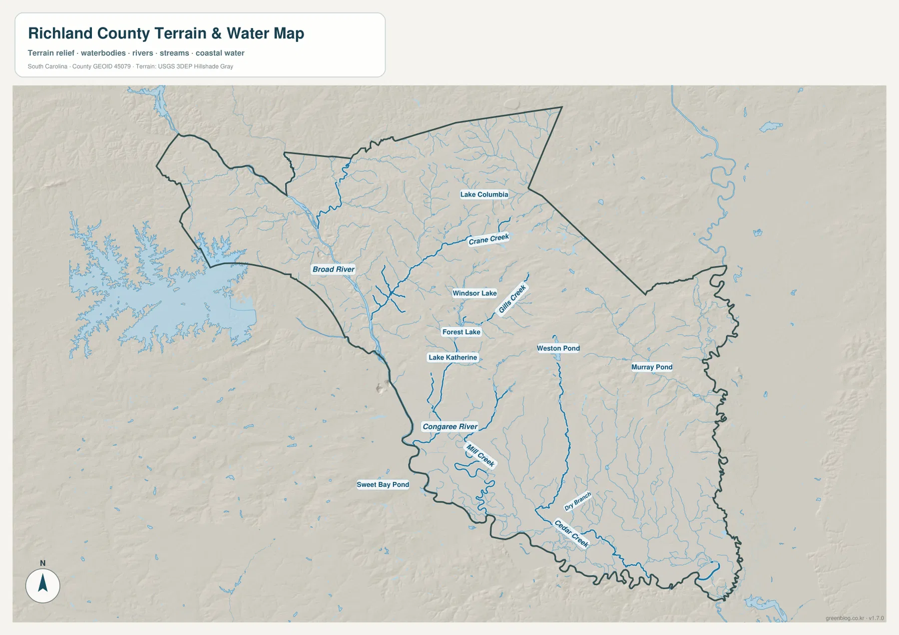
The terrain-and-water map changes the visual emphasis completely. The Broad River enters from the northwest and follows the western side of the county toward Columbia. South of the central city, the same major corridor continues as the Congaree River. On the road map this area is visually busy because so many highways converge, but the water map makes the river boundary much easier to see.
Smaller channels fill in the rest of the county. Crane Creek and Gills Creek are labeled through the central and northeastern area, while Mill Creek, Dry Branch, and Cedar Creek appear farther south. These waterways are useful geographic references, but the map is not a flood-hazard, navigation, or water-level product. It should be used to understand the location of streams and lakes, not to make decisions about inundation or channel conditions.
Small lakes help separate neighborhoods inside the Columbia area
Several named water bodies appear close to the urban center. Lake Columbia is shown northeast of central Columbia, while Windsor Lake, Forest Lake, and Lake Katherine sit closer to the developed area. They are much smaller than the Broad River corridor, but their labels provide useful local reference points when the main road map becomes crowded with highways and place names.
Farther east and south, Weston Pond and Murray Pond appear away from the central lake cluster, while Sweet Bay Pond is labeled near the southwest outside edge of the county view. Lake Murray is also visible beyond the western side of the county. Grouping the central lakes separately from the more distant ponds makes the water map easier to read and avoids treating every named water body as if it had the same geographic role.
Relief is more noticeable in the northwest than across the broad southern section
The hillshade does not show mountain terrain, but the northwestern and western parts of the map have more visible surface texture than much of the south and southeast. South of Columbia the terrain appears broader and gentler, allowing the stream network to stand out against a relatively subdued background. This is a useful visual contrast, but exact elevations require dedicated elevation data rather than the shaded-relief preview.
Combining relief with the settlement pattern also helps explain the county’s internal contrast. Columbia occupies a dense central zone with many roads and nearby named lakes, while the southern half has fewer major place labels and more visible tributaries. Blythewood in the north sits in yet another setting, separated from the central urban cluster by a longer band of roads and drainage lines.
A practical way to move from a city name to roads and rivers
For a quick location check, start with the city map. It immediately separates Columbia, Irmo, Blythewood, and Eastover into different parts of the county. Next, use the general county map to add I-20, I-26, I-77, US 1, US 21, US 321, and the smaller routes. This sequence works better than beginning with the busiest road map when the only question is where a city lies.
When water or terrain matters, finish with the terrain-and-water map. The Broad River provides a clear western reference for Columbia, the Congaree continues south, and the smaller creeks become easier to follow without road labels competing for attention. The WebP files on the page are optimized for screen viewing; the ZIP below contains the matching A3 JPG originals for printing and larger layouts.
These maps are general geographic references rather than live-traffic, legal-boundary, parcel, flood-risk, or survey products. Road conditions can change, legal boundaries require authoritative records, and the shaded terrain does not provide exact spot elevations. Use current official sources whenever a decision depends on those details.
Frequently Asked Questions
Which map is best for comparing Columbia with Blythewood, Irmo, and Eastover?
The city map is the quickest choice because it separates the six ranked places without the full road network. After locating Blythewood north of Columbia, Irmo to the west, or Eastover to the southeast, switch to the county map for the relevant highways and local routes.
Where are the Broad River and Congaree River shown?
They are clearest on the terrain-and-water map. The Broad River runs down the western side toward Columbia, and the Congaree River continues south from the metropolitan area. Smaller waterways such as Crane Creek, Gills Creek, Mill Creek, and Cedar Creek are shown there as well.
What is included in the downloadable ZIP?
The archive contains three high-resolution A3 JPG files corresponding to the page previews: the general county map, the ranked city map, and the terrain-and-water map. The WebP versions in the article are lighter files intended for browser viewing.
Map File Information
Download the Richland County road map, ranked city map, and terrain-and-water map together as high-resolution A3 JPG files.
- Included Files: 3 JPG maps
Related Maps
Sources and Reference Data
- U.S. Census Bureau TIGER/Line Shapefiles: county boundaries, roads, and geographic reference data
- USGS National Hydrography: rivers, streams, lakes, and hydrographic reference data
- USGS 3D Elevation Program: terrain and elevation reference data
- South Carolina Association of Counties: county administrative reference information
Green Map creates custom-edited map images using open geographic data sources such as geoBoundaries, Natural Earth, OpenStreetMap, and government open data.
These maps are edited visual materials, not raw data files, and are provided for education, documents, presentations, and graphic reference.