The Pickens County South Carolina Map set on this page combines the county road network, ranked city distribution, and terrain-and-water detail in one downloadable reference. You can preview Pickens, Easley, Clemson, Liberty, major routes such as 123 and 178, Lake Keowee, the South Saluda River, Oolenoy River, and Twelve Mile Creek, then download the matching high-resolution A3 JPG files in a ZIP archive. The three maps are especially useful here because the county changes noticeably from the more urbanized south to the rugged northern terrain.
Easley and Clemson provide strong southern reference points, while Pickens sits farther north near the center of the county and Six Mile lies to the west. Lake Keowee runs along much of the western side, and Lake Hartwell and the Seneca River appear near the southwest. In the north, the relief becomes much rougher and tributaries converge toward the South Saluda and Oolenoy river systems. Looking at the road map together with the terrain-and-water map makes that north-south contrast much clearer than a boundary-only map could.
Table of Contents
Roads tie Pickens to Easley, Liberty, Central, and Clemson
The general county map puts Pickens and Easley near the center of the road story. Route 8 runs through the Pickens area, while 186 and 135 appear to the east and northeast. Easley has a denser local network, with 93 and 178 providing useful references around the city. Moving south from Pickens brings Liberty into view, followed by Central and Clemson near the southern edge. This sequence gives the southern half of the county a recognizable chain of places even before the smaller roads are considered.
Route 123 is the clearest southern corridor on the supplied map, passing through the Clemson-Central side and continuing east. Route 137 descends from the Six Mile area, while 183 and 11 are useful on the western side toward Lake Keowee and the northwestern interior. Farther north, 288 and 135 help organize the less urban road pattern. The road map also shows streams beneath the transportation layer, so it is possible to see where routes cross drainage lines and where the network becomes less dense in the rougher northern terrain.
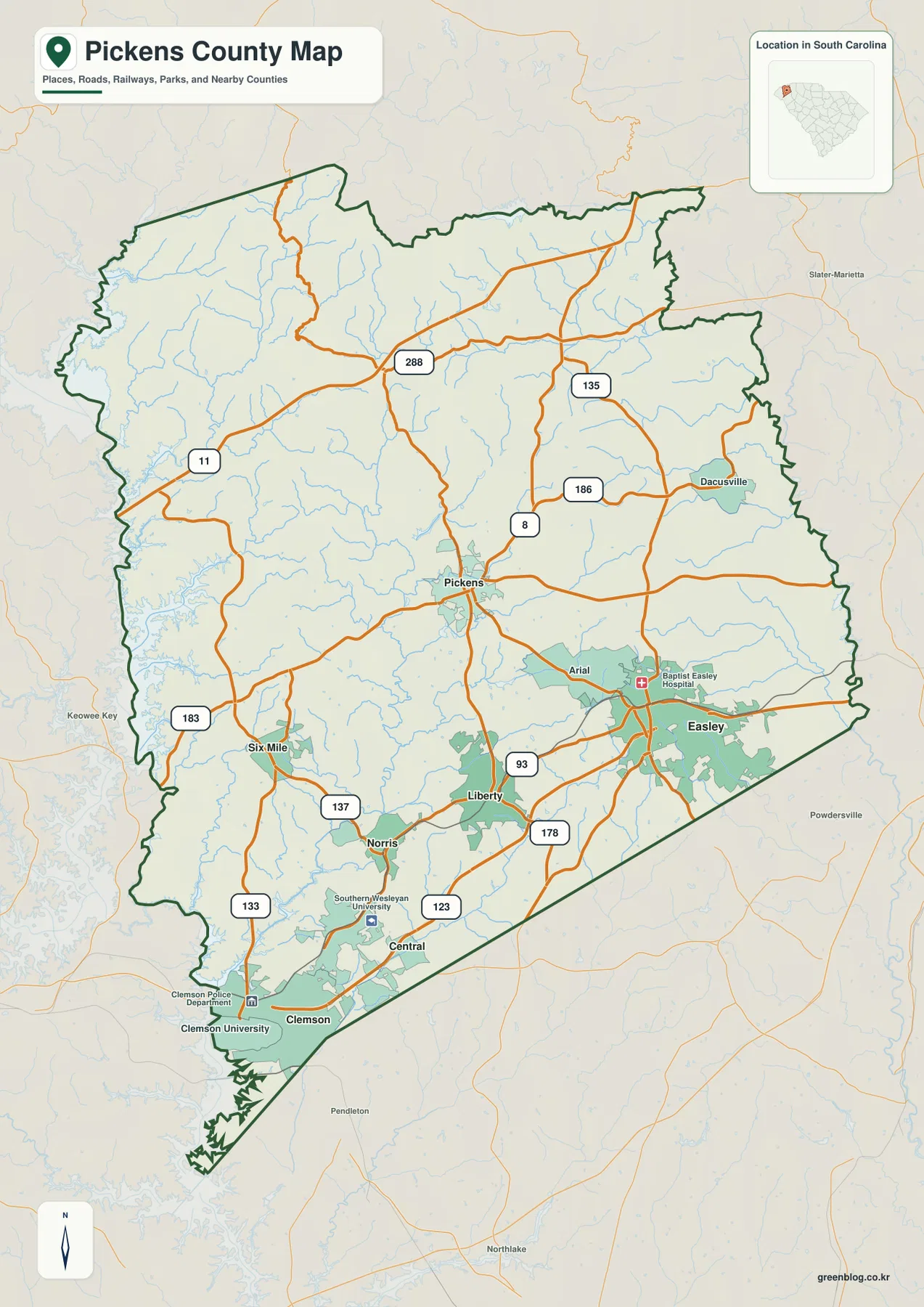
Several labeled landmarks help confirm the southern city pattern. Clemson University appears near Clemson at the southwestern end of the county, Southern Wesleyan University is marked near Central, and Baptist Easley Hospital is labeled in the Easley area. These features are not the focus of the map, but they make the city positions easier to recognize. Easley occupies the eastern side, Pickens is more central, and Clemson sits close to the southern county edge.
Six ranked cities form a southern arc with Pickens and Six Mile farther north
The city-distribution map ranks Easley first, Clemson second, Central third, Liberty fourth, Pickens fifth, and Six Mile sixth. The ranking panel also displays population figures for those six places, but the map is most useful for seeing their positions. Easley sits on the eastern side, Clemson is near the southwestern tip, Central and Liberty occupy the southern interior, Pickens is farther north, and Six Mile lies to the west. The result is a pattern in which most of the highlighted cities are concentrated in the lower half of the county.
The surrounding county labels add useful context. Oconee County lies to the west, Greenville County to the east, and Anderson County is shown to the south. Clemson is close to the Anderson County side, Easley is nearest the Greenville County side, and Six Mile is closer to Oconee County. Those neighboring labels make the city distribution easier to remember because each highlighted place is tied to a different edge of Pickens County rather than floating in an isolated outline.
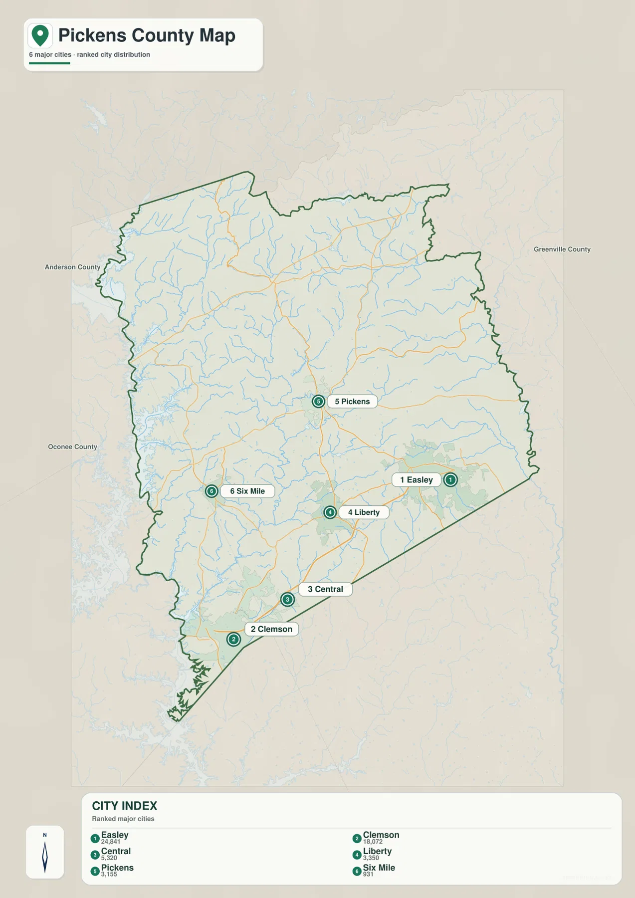
The city map is not a driving-distance or travel-time chart. It is designed for quick placement and ranking. If you want to compare Clemson with Easley, first use the city map to see opposite sides of the southern county, then switch to the road map to follow Route 123 and the other labeled routes. Separating those two tasks keeps both maps readable.
Mountain headwaters descend toward Lake Keowee and the southern reservoirs
The terrain-and-water map shows the strongest geographic contrast in the package. The northern third is heavily textured with ridges and narrow valleys, while the relief becomes progressively gentler toward Clemson, Liberty, and Easley. The South Saluda River is labeled in the northeast, and the Oolenoy River runs across the upper central section. Lake Oolenoy and Garren Lake sit close to this northern drainage, with many smaller tributaries feeding the larger channels from the surrounding slopes.
Lake Keowee is the dominant water feature along the western side, with the Keowee River label following the same general corridor. Farther south, the Seneca River and Lake Hartwell appear near the southwestern corner. Twelve Mile Creek cuts through the central-southern part of the county toward that reservoir system, and Eighteen Mile Creek is labeled near the southeastern boundary. The map therefore connects mountain streams in the north with large lake and river systems farther south.
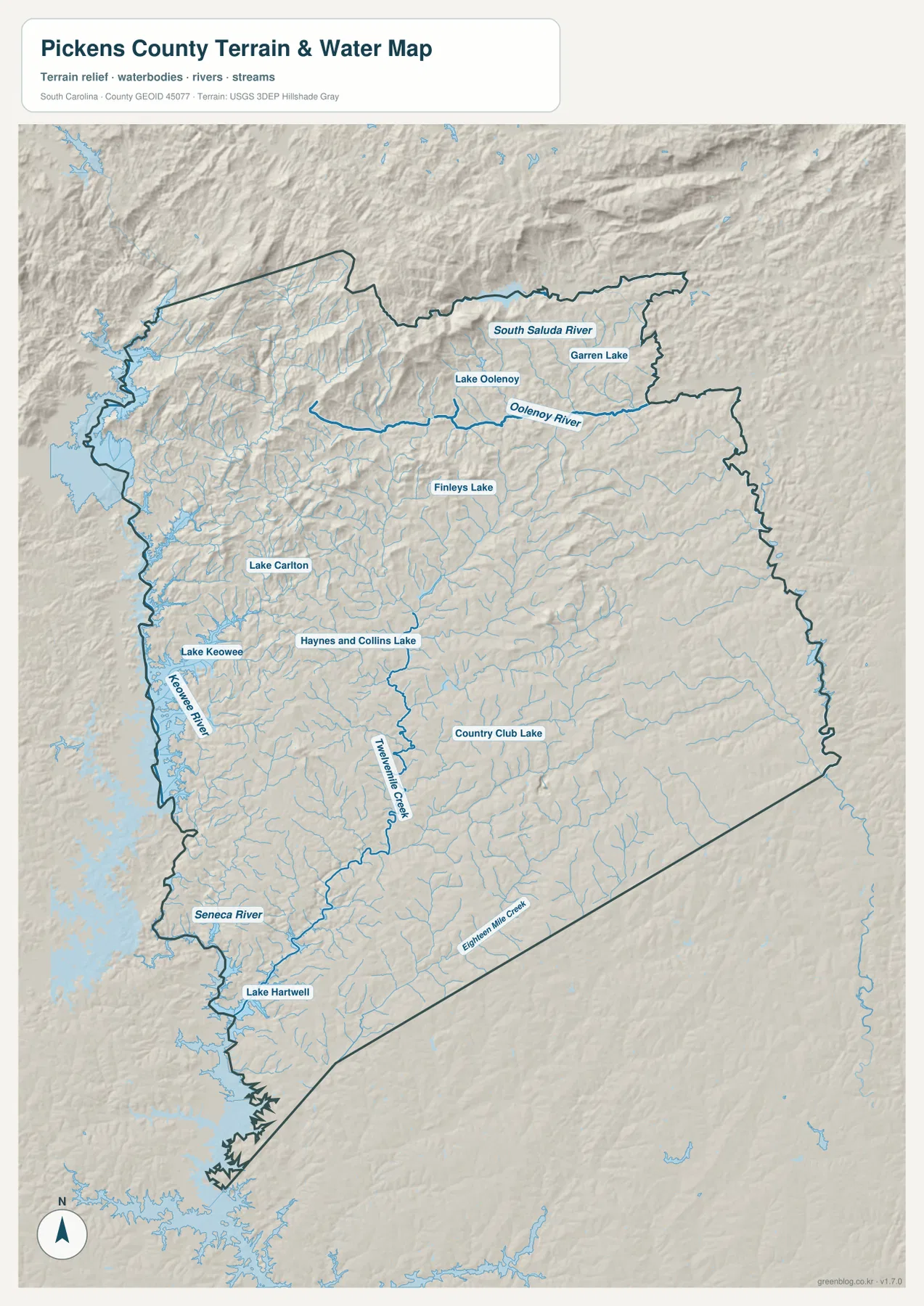
The shaded relief is not a contour map and does not provide survey-grade elevations, but it clearly shows the change in landform. Northern valleys are narrow and closely spaced, while the southern part of the county has broader surfaces around the main towns. That difference also helps explain the road pattern: the northern routes bend through more irregular terrain, whereas the southern network is denser around Easley, Liberty, Central, and Clemson.
Smaller named lakes fill the space between the major river systems
The water map identifies several smaller lakes that would be easy to overlook if attention stayed only on Lake Keowee and Lake Hartwell. Lake Oolenoy and Garren Lake appear in the north, Finleys Lake in the north-central area, and Lake Carlton farther west. Haynes and Collins Lake is labeled in the central-western portion of the county, while Country Club Lake appears farther southeast. Together they show that surface water is distributed across the interior as well as along the large western reservoirs.
The named creeks provide another set of reference lines. Twelve Mile Creek is the most prominent interior creek on the map and runs toward the southwest, while Eighteen Mile Creek follows the lower eastern side. Oolenoy River and South Saluda River occupy the mountainous north. Using only a few of these labels is enough to separate the county into distinct water landscapes without turning the page into a catalog of every minor tributary.
Choose the map by the question: city position, road access, or terrain and water
For a quick comparison of Easley, Clemson, Pickens, and Six Mile, start with the ranked city map. Use the general county map when route numbers or road connections matter. Move to the terrain-and-water map when the question involves Lake Keowee, Lake Hartwell, mountain streams, or the change in relief from north to south. That sequence is especially effective in Pickens County because the same place can look very different depending on whether the emphasis is roads, settlements, or physical geography.
The WebP images in the article are lightweight previews for browser viewing. The downloadable ZIP contains the corresponding high-resolution A3 JPG files for the county road map, city-distribution map, and terrain-and-water map. Those larger files are better suited to printing, reports, classroom materials, and side-by-side county comparison.
These maps are general geographic references. They are not live-navigation, parcel-boundary, flood-risk, engineering, or survey products. Road conditions can change, legal boundaries require authoritative records, and the relief shading should not be read as exact spot elevation. Use current official sources whenever a decision depends on those details.
Frequently Asked Questions
Which map is best for comparing Easley, Clemson, and Pickens?
The ranked city map is the quickest choice. Easley is on the eastern side, Clemson is near the southwestern end, and Pickens sits farther north near the center. After locating them, use the road map to add Route 123, 178, 93, 8, and other numbered routes.
Where can I see Lake Keowee and the South Saluda River?
Use the terrain-and-water map. Lake Keowee follows the western side of the county, while the South Saluda River is labeled in the mountainous northeast. The same map also shows Oolenoy River, Twelve Mile Creek, Seneca River, Lake Hartwell, and several smaller lakes.
What files are included in the downloadable ZIP?
Inside the ZIP are three high-resolution A3 JPG originals: one for roads and county places, one for the ranked city distribution, and one for terrain and water. The lighter WebP versions in the article are intended for quick screen viewing.
Map File Information
Download the Pickens County road map, ranked city map, and terrain-and-water map together as high-resolution A3 JPG files.
- Included Files: 3 JPG maps
Related Maps
Sources and Reference Data
- U.S. Census Bureau TIGER/Line Shapefiles: county boundaries, roads, and geographic reference data
- USGS National Hydrography: rivers, streams, lakes, and hydrographic reference data
- USGS 3D Elevation Program: terrain and elevation reference data
- South Carolina Association of Counties: county administrative reference information
Green Map creates custom-edited map images using open geographic data sources such as geoBoundaries, Natural Earth, OpenStreetMap, and government open data.
These maps are edited visual materials, not raw data files, and are provided for education, documents, presentations, and graphic reference.