The Orangeburg County Map on this page brings the county’s road network, ranked city distribution, and waterways into one downloadable reference set. You can preview Orangeburg, Santee, Holly Hill, Branchville, the I-26 and I-95 corridors, the Edisto River branches, and named creeks and ponds here, then download the matching high-resolution A3 JPG files in a ZIP archive. The supplied maps show why Orangeburg County is easier to understand as a long east-west county with several distinct centers rather than as a single cluster around the county seat.
The general county map is the best starting point for roads and place names. The city map strips away much of that detail and highlights six ranked places: Orangeburg, Holly Hill, Branchville, Santee, Elloree, and Bowman. The terrain-and-water map shifts attention again, following the North Fork Edisto River, South Edisto River, Cow Castle Creek, Four Hole Swamp, Shingler Run, and numerous ponds. Using the maps in sequence makes it possible to move from a town name to a road corridor and then to the surrounding drainage without forcing all of that information into one crowded image.
Table of Contents
Orangeburg forms the road-network hinge in the middle of the county
Orangeburg stands near the center of the county map and is surrounded by several of the most useful route labels. US 301 and US 601 provide clear reference lines close to the city, while 400, 321, 332, 3, 39, and 178 extend toward Neeses, Springfield, North, and the western side of the county. South of Orangeburg, the map leads toward Rowesville and Branchville. To the southeast, Bowman sits on a different branch of the network before the county widens again toward Santee, Holly Hill, and Eutawville.
The eastern half has a different road pattern from the west. I-26 crosses the county east of Orangeburg and passes the Bowman side of the map, while I-95 appears around Santee. Route 267 is shown near the Santee and Elloree area, 45 runs toward Eutawville, and 15 and 176 help organize the Holly Hill side. This combination makes the east much easier to read when the interstate shields are used first and the smaller numbered roads are added afterward. In the west, Springfield and Neeses are better located from the smaller state-route labels because the interstates are farther away.
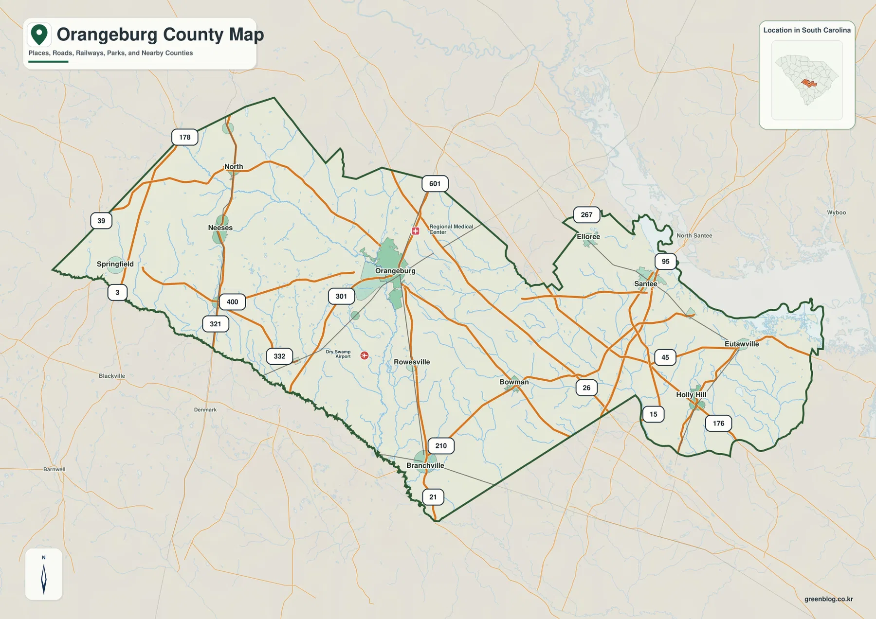
The road map also includes smaller communities that do not appear in the ranked city panel. North, Neeses, Springfield, Rowesville, Eutawville, and several other labels fill in the gaps between the six highlighted places. That matters in a county this broad because a reader can otherwise underestimate the distance between the western and eastern sections. Orangeburg works as the central reference, Branchville lies to the southwest, Bowman to the southeast, and Santee and Holly Hill are farther east. The route labels make those directional relationships much more useful than a simple list of town names.
The six-city index stretches from Branchville to Holly Hill and Santee
The city-distribution map ranks Orangeburg first, Holly Hill second, Branchville third, Santee fourth, Elloree fifth, and Bowman sixth. More important than the ranking itself is the geometry of the markers. Orangeburg occupies the central portion of the county, Branchville sits well to the southwest, Bowman lies southeast of Orangeburg, and the Holly Hill-Santee pair is farther east. Elloree is north of Santee and close to the northeastern side of the county. The markers therefore form several separate groups instead of one compact urban cluster.
County names around the outside of the city map provide another layer of orientation. Bamberg, Dorchester, and Barnwell counties are labeled along the west and southwest sides; Calhoun and Lexington appear to the north; Clarendon and Berkeley are shown to the east. These surrounding labels help explain why Branchville is close to the southwestern edge while Santee and Holly Hill are associated with the eastern side. Orangeburg remains the easiest internal anchor because it sits between those outer groups rather than at one extreme.
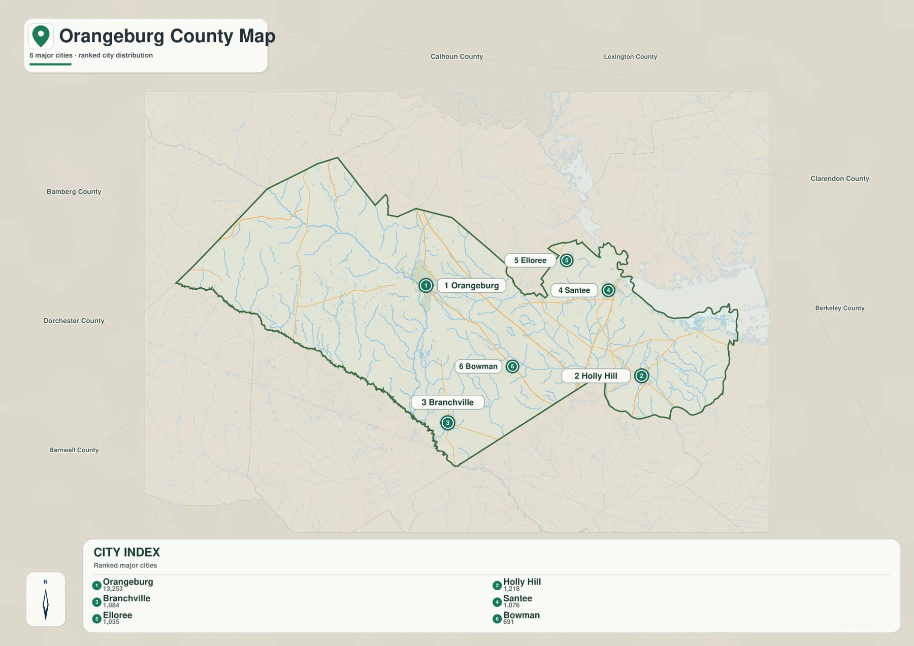
The city index is not a mileage chart or a turn-by-turn route planner. Its strength is quick placement. If the question is where Santee lies compared with Orangeburg, the city map answers that immediately; the county map can then be used to add I-26, I-95, and the smaller routes. The same process works for Branchville and Bowman, which are both south of Orangeburg but on different sides of the county. Separating location from road detail keeps the map readable and reduces the chance of confusing straight-line placement with actual travel distance.
Edisto River branches dominate the west while Four Hole Swamp stands out in the east
The terrain-and-water map has a very different visual center. The North Fork Edisto River enters from the northwest and runs diagonally through the western and central part of the county before continuing south. The South Edisto River is labeled along the southwest side. Between and around those larger channels, smaller tributaries create a dense branching network. Cow Castle Creek crosses the central-eastern section, while Four Hole Swamp is labeled farther east as a long wetland corridor rather than a conventional river line.
Several additional names make the southern and eastern drainage easier to follow. Mill Branch and Cattle Creek appear in the south-central area, and Shingler Run is labeled near the eastern end of the county. The northeastern and eastern boundary also touches a broad body of water that is visually much larger than the interior creeks and ponds. Even without using that large waterbody as the only reference, the map clearly separates an Edisto-centered western drainage from an eastern landscape where swamp channels, runs, and the broad boundary water become more prominent.
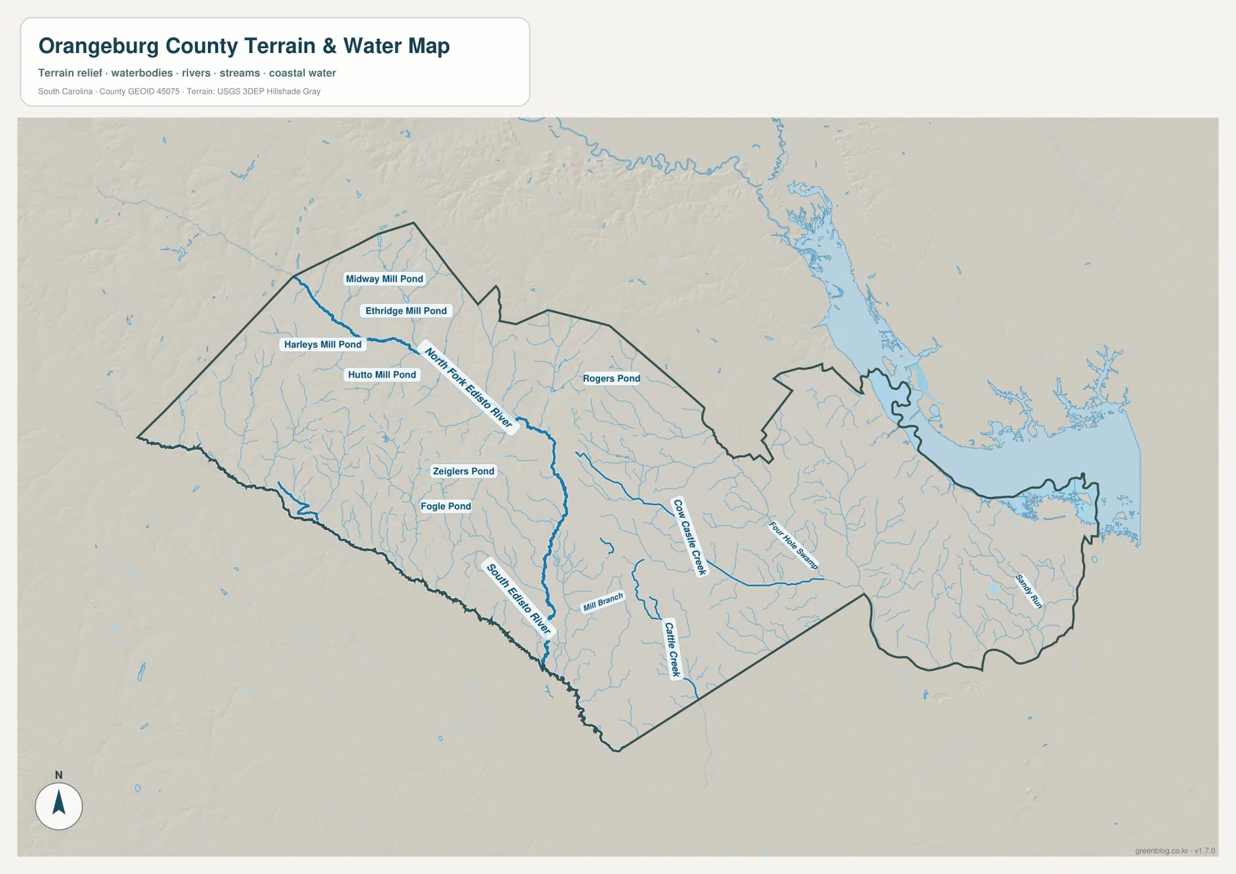
Relief shading is comparatively gentle across much of the supplied map. The watercourses are more visually important than steep ridges or mountain slopes, and many small tributaries can be traced through broad, low-relief terrain. For this county, the hillshade is most useful as a background that helps the drainage lines stand out. It is not a contour map and should not be used to read exact elevations, but it does make the contrast between the dense western tributaries and the eastern swamp-and-run system easier to see.
Named mill ponds add detail to the western half of the water map
The western half contains an unusually useful set of named ponds. Midway Mill Pond, Ethridge Mill Pond, Harleys Mill Pond, and Hutto Mill Pond are clustered near the North Fork Edisto River side of the map. Farther south are Zeiglers Pond and Fogle Pond, while Rogers Pond appears farther east in the north-central area. These labels make the water map useful at a finer scale than a map that shows only the main rivers. They also give the western portion a distinct character that is not obvious on the road map.
Moving east changes the kind of water feature that stands out. Cow Castle Creek becomes a strong labeled line through the center, Four Hole Swamp occupies the eastern half, and Shingler Run appears near the far eastern boundary. That shift is useful when explaining Orangeburg County geographically: the map does not show one single river system repeated from end to end. Instead, the west is organized around Edisto branches and numerous ponds, while the east is increasingly defined by creek, swamp, run, and broad boundary-water features.
Use city placement first, roads second, and waterways when more context is needed
A simple workflow works well with this set. Start with the city map when you only need to know whether a place lies west, central, or east. Move to the county map to add route numbers and nearby communities. Finish with the terrain-and-water map when rivers, swamps, ponds, or drainage are part of the question. For Santee, for example, the city map establishes the eastern position, the county map brings I-95 and nearby routes into view, and the water map shows the strong influence of the broad eastern water boundary and local drainage.
The WebP images in the article are optimized for quick browser viewing. For printing, presentation layouts, classroom materials, or side-by-side county comparison, the ZIP archive contains the matching high-resolution A3 JPG files. Each file emphasizes a different task, so the reader can use the road map, city-distribution map, or terrain-and-water map without trying to extract every detail from a single image.
These maps are general geographic references, not live-navigation, legal-boundary, engineering, or flood-risk products. Road conditions and access can change, parcel boundaries require authoritative cadastral records, and the terrain shading does not provide exact spot elevations. Use current official sources when a decision depends on those kinds of details.
Frequently Asked Questions
Which map is best for comparing Orangeburg with Santee and Holly Hill?
The city-distribution map is the quickest choice because it isolates the six ranked places and makes the east-west separation easy to see. After locating Santee and Holly Hill east of Orangeburg, switch to the county map to add I-26, I-95, and nearby route numbers.
Where can I see the Edisto River branches and Four Hole Swamp?
Use the terrain-and-water map. The North Fork Edisto River crosses the western and central part of the county, the South Edisto River is labeled along the southwest side, and Four Hole Swamp is shown in the eastern half. Cow Castle Creek and several smaller tributaries are visible there as well.
What files are included in the downloadable ZIP?
The ZIP contains three high-resolution A3 JPG files corresponding to the maps shown on the page: the county road map, the ranked city-distribution map, and the terrain-and-water map. The WebP images in the article are lighter preview versions for screen viewing.
Map File Information
Download the Orangeburg County road map, ranked city map, and terrain-and-water map together as high-resolution A3 JPG files.
- Included Files: 3 JPG maps
Related Maps
Sources and Reference Data
- U.S. Census Bureau TIGER/Line Shapefiles: county boundaries, roads, and geographic reference data
- USGS National Hydrography: rivers, streams, swamps, ponds, and hydrographic reference data
- USGS 3D Elevation Program: terrain and elevation reference data
- South Carolina Association of Counties: county administrative reference information
Green Map creates custom-edited map images using open geographic data sources such as geoBoundaries, Natural Earth, OpenStreetMap, and government open data.
These maps are edited visual materials, not raw data files, and are provided for education, documents, presentations, and graphic reference.