Oconee County South Carolina Map visitors can use this page to compare roads, towns, lakes, rivers, and mountain relief, then download the matching A3 high-resolution JPG maps in one ZIP file. Oconee occupies the far northwestern corner of South Carolina, and its shape changes noticeably from the rugged lake-and-river country in the north to the road network around Walhalla, Seneca, and Westminster farther south. The three supplied maps separate those layers so the county can be understood without crowding every label onto one image.
The road map is the best starting point for places such as Walhalla, Seneca, Westminster, Salem, Tamassee, and Fair Play. The city map strips away much of that detail and ranks five major municipalities—Seneca, Walhalla, Westminster, West Union, and Salem—so their relative positions are easy to compare. The terrain-and-water map shifts attention to Lake Jocassee, Lake Keowee, Hartwell Lake, the Chattooga River, the Chauga River, and the steep relief of the northern half of the county. Used together, the maps show why Oconee does not read like a single uniform landscape.
Table of Contents
Roads tighten around Walhalla and Seneca, then spread into the mountains
Walhalla sits near the middle of the county’s main road network. Route 28 passes close to the city, while 183 extends west and 188 runs eastward. South of Walhalla, the map shows the road system becoming denser around Westminster and Seneca, where 76 and 123 form useful reference lines. Farther north, 107 reaches into the higher-relief part of the county, and 130 connects the Salem side of the map with the Lake Keowee corridor. At the southern tip, routes 11, 59, 85, 182, and 24 help define the approaches to Fair Play, Chickasaw Point, and the reservoir edge.
The county map also labels smaller places that make the road network easier to interpret. Tamassee lies north of Walhalla, Salem is farther northeast, Keowee Key is near the eastern water corridor, and Newry and Utica appear between the larger urban labels around Seneca. Longcreek is isolated toward the western mountain side, while South Union and Chickasaw Point sit much farther south. Those locations make it clear that a trip across Oconee is not simply an east-west movement between two cities; the county stretches from mountain communities to reservoir-side and interstate-adjacent areas.
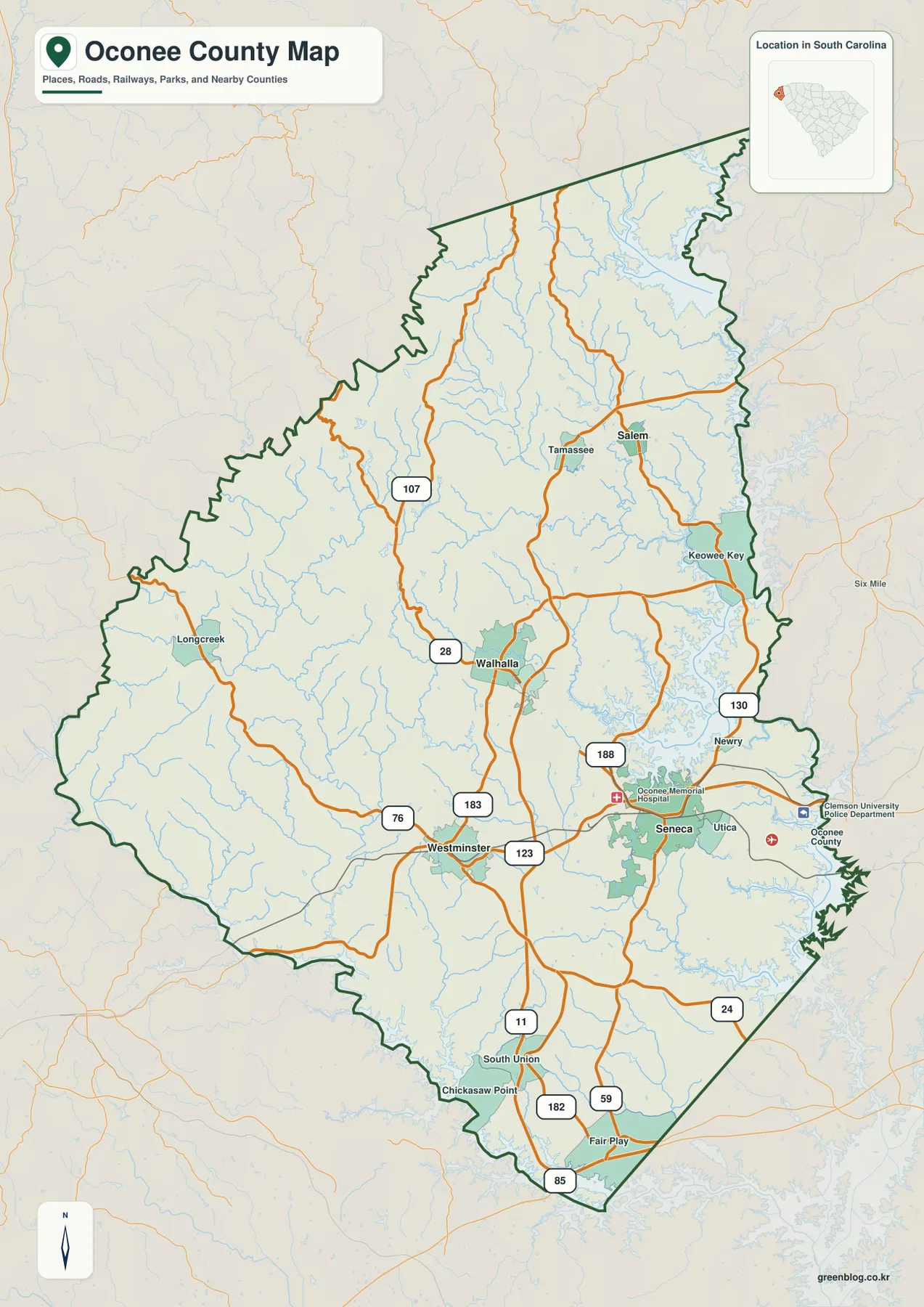
The outline itself is another useful clue. The northern and western sides are irregular, the southeastern edge follows a broad reservoir zone, and the county narrows toward a pointed southern end. Roads respond to that shape differently in each section. Around Seneca and Walhalla several routes intersect within a relatively compact area, while the mountain side contains longer stretches between labeled roads. The result is a county map where road density, water, and terrain all change together from north to south.
Five city markers reveal a north–south split
The city index ranks Seneca first, Walhalla second, Westminster third, West Union fourth, and Salem fifth. More important than the ranking is the spacing. Seneca sits in the southeast-central part of the county, Walhalla is northwest of it, and Westminster is farther southwest. West Union is close to Walhalla, while Salem stands well to the north of the other four. That separation gives the map a clear north–south pattern: the larger cluster is in the central and southern half, while Salem serves as the principal labeled city reference in the lake-and-mountain country to the north.
This view is especially useful when comparing Oconee with the counties shown beyond its eastern edge. Pickens County is labeled to the northeast and Anderson County to the southeast. Seneca appears relatively close to that eastern side, whereas Walhalla and Westminster are set farther inland. Salem is separated from the southern cluster by a large area of streams and rugged terrain. The city map therefore works well as a quick orientation sheet before returning to the more detailed road map.
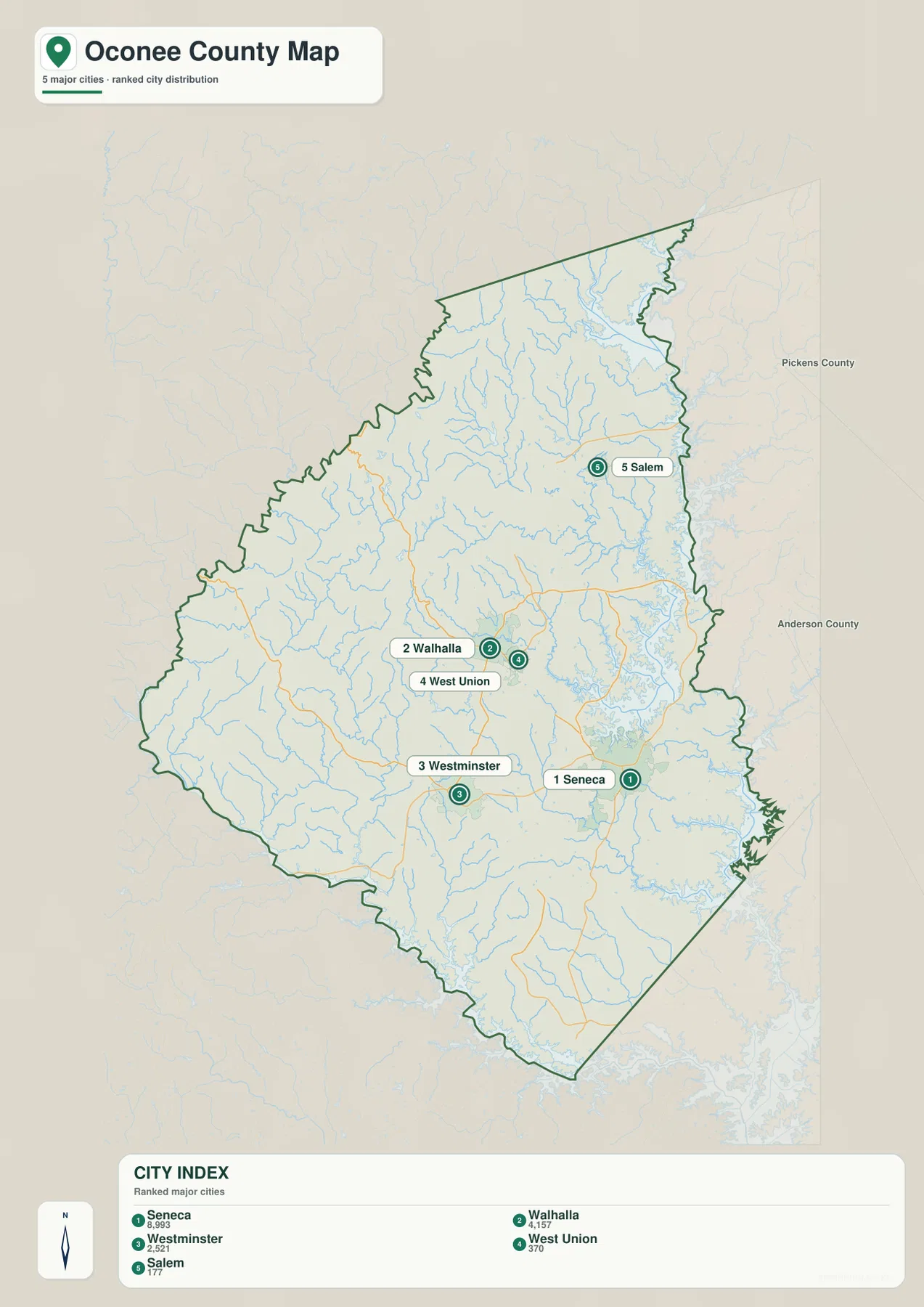
The city index should not be read as a driving-distance chart. It is designed to show relative placement and rank. A practical way to use it is to locate the city first, then switch to the county map for numbered roads. For Salem, that means identifying the northern position on the city map and then checking 130 and 107 on the road map. For Seneca and Westminster, the same approach brings 76 and 123 into view and makes their east-west relationship much easier to follow.
Jocassee, Keowee, and Hartwell frame the county with water
The terrain-and-water map changes the emphasis completely. Lake Jocassee occupies a large basin in the northeast, with the Toxaway River entering from the north. Below it, the Keowee River and Little River run south through the eastern half of the county. Lake Keowee forms a long, branching body of water through that same side of the map, while Hartwell Lake appears along the southeast corner. On the opposite side, the Chattooga River follows the western mountain border, and the Chauga River is a major interior watercourse in the western and southwestern part of the county.
Smaller water bodies add another layer of detail. Lake Isaqueena appears north of the county’s center, with Lake Becky and Crystal Lake to the west-central side. Browns Lake and Coneross Creek Reservoir are farther south, and Coneross Creek continues toward the lower eastern portion of the map. These names matter because they prevent the county from being reduced to only its three largest reservoirs. The map shows a connected system of rivers, smaller lakes, creeks, and reservoir arms extending from the mountains to the southern boundary.
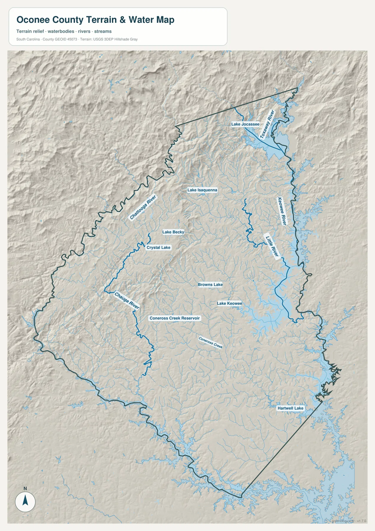
The water map also explains why city positions feel so different across the county. Salem lies close to the northern reservoir country, while Seneca is positioned between the Lake Keowee system and the broad Hartwell Lake side of the southeast. Longcreek is more closely associated with the Chattooga River side of the mountain interior. Walhalla and Westminster sit between those water-defined edges, where the road map becomes more useful than the water map for everyday orientation.
The northern half is visibly steeper than the southern end
Hillshade makes the change in relief easy to see. North of Walhalla, the background becomes increasingly rugged, with closely spaced ridges, narrow valleys, and short tributaries feeding larger rivers and lakes. The Lake Jocassee and Chattooga River areas show the strongest relief on the supplied map. Moving south toward Seneca, Westminster, and Fair Play, the surface becomes less sharply folded. Rolling terrain remains visible, but the pattern is broader and smoother than in the northern mountain section.
This map is intended for relative terrain reading rather than precise elevation measurement. It does not provide a contour value for every ridge or valley. What it does show clearly is where the strongest relief is concentrated and how streams occupy the lower ground between ridges. That makes the water map useful alongside the road map: a reader can see why the northern part of the county is visually dominated by topography and drainage, while the central and southern portions contain a denser network of labeled roads and towns.
Choose the map by the question you are trying to answer
For a quick location check, start with the county road map. It places town names, road numbers, streams, and the county boundary on the same page. If the question is simply where Seneca sits relative to Walhalla, Westminster, West Union, or Salem, the city map removes much of the extra detail. If the goal is to understand Lake Jocassee, Lake Keowee, the Chattooga River, or the mountain relief, the terrain-and-water map is the clearest choice.
Salem is a good example of how the maps complement one another. Its city marker establishes that it lies far north of the main central cluster. The road map then shows 130 and 107 in the same general area, while the water map places Salem between the Lake Jocassee and Lake Keowee systems. Seneca works differently: the city map identifies it as the southeastern member of the main group, the road map adds 123 and 76, and the water map shows its position near Lake Keowee and the Hartwell Lake side of the county.
A3 JPG files for printing and county comparison
The WebP images on this page are optimized for on-screen viewing. For printing, classroom use, report layouts, or side-by-side comparison with other county maps, use the full A3 JPG files in the ZIP archive. The county map is best for roads and place names, the city map for ranked municipal distribution, and the terrain-and-water map for reservoirs, rivers, streams, and relief.
These maps are general geographic references rather than legal survey products or live navigation tools. Use current authoritative sources when a task depends on parcel boundaries, real-time road conditions, engineering measurements, or regulatory water boundaries. The terrain shading is also qualitative: it is meant to show the shape of ridges and valleys, not to replace a detailed elevation dataset.
Frequently Asked Questions
Which map is easiest for comparing Seneca, Walhalla, and Westminster?
The city map is the quickest choice because it isolates the five ranked city markers. Seneca is southeast of Walhalla, while Westminster lies farther southwest. After locating them there, use the county map to add route numbers such as 28, 76, and 123.
Where are Lake Jocassee and Lake Keowee on the Oconee County map?
Lake Jocassee is in the rugged northeastern mountain section of the terrain-and-water map. Lake Keowee extends south from that area through the eastern half of the county. Hartwell Lake appears farther south along the southeastern edge.
What is included in the downloadable ZIP?
The ZIP contains three high-resolution A3 JPG files matching the maps shown on this page: the county road map, the ranked city map, and the terrain-and-water map. The WebP images in the article are preview versions for faster browser viewing.
Map File Information
Download the Oconee County road map, ranked city map, and terrain-and-water map together as high-resolution A3 JPG files.
- Included Files: 3 JPG maps
Related Maps
Sources and Reference Data
- U.S. Census Bureau TIGER/Line Shapefiles: county boundaries, roads, and geographic reference data
- USGS National Hydrography: lakes, rivers, streams, and hydrographic reference data
- USGS 3D Elevation Program: elevation and terrain-shading reference data
- South Carolina Geological Survey: statewide terrain and geology map resources
Green Map creates custom-edited map images using open geographic data sources such as geoBoundaries, Natural Earth, OpenStreetMap, and government open data.
These maps are edited visual materials, not raw data files, and are provided for education, documents, presentations, and graphic reference.