Cannon County lies in Middle Tennessee, with Woodbury near the center of a landscape broken into narrow valleys, wooded ridges, and closely spaced streams. The maps on this page follow the county from that central point outward: numbered roads connect Woodbury with the surrounding county lines, Auburntown marks the northwestern settlement area, East Fork Stones River crosses the central valleys, and the elevation image shows why the eastern side appears much rougher than the west. A ZIP with the matching high-resolution A3 JPG files is available for download after the map discussion.
Woodbury is the best place to begin because several mapped roads meet near the middle of the county and East Fork Stones River passes close to the same area. Auburntown appears well to the northwest, while much of the eastern and southern county is defined more by ridges, valleys, and drainage lines than by large settlement labels. Reading the maps in that order—center first, then roads, water, and elevation—makes it easier to understand why short straight-line separations do not always translate into simple travel routes.
Table of Contents
Woodbury and the roads that organize the county
The general county map places Woodbury near the middle of the boundary and shows US 70S with State Route 1 crossing the central area from west to east. Route 145 approaches from the north, while Route 53 runs south from the Woodbury area toward the county line. Routes 146, 281, 70, 99, 64, and 96 appear around the outer parts of the county, giving the map a useful set of directional references for travel toward neighboring counties. The image is intentionally selective, so it is better for county-scale orientation than for turn-by-turn driving.
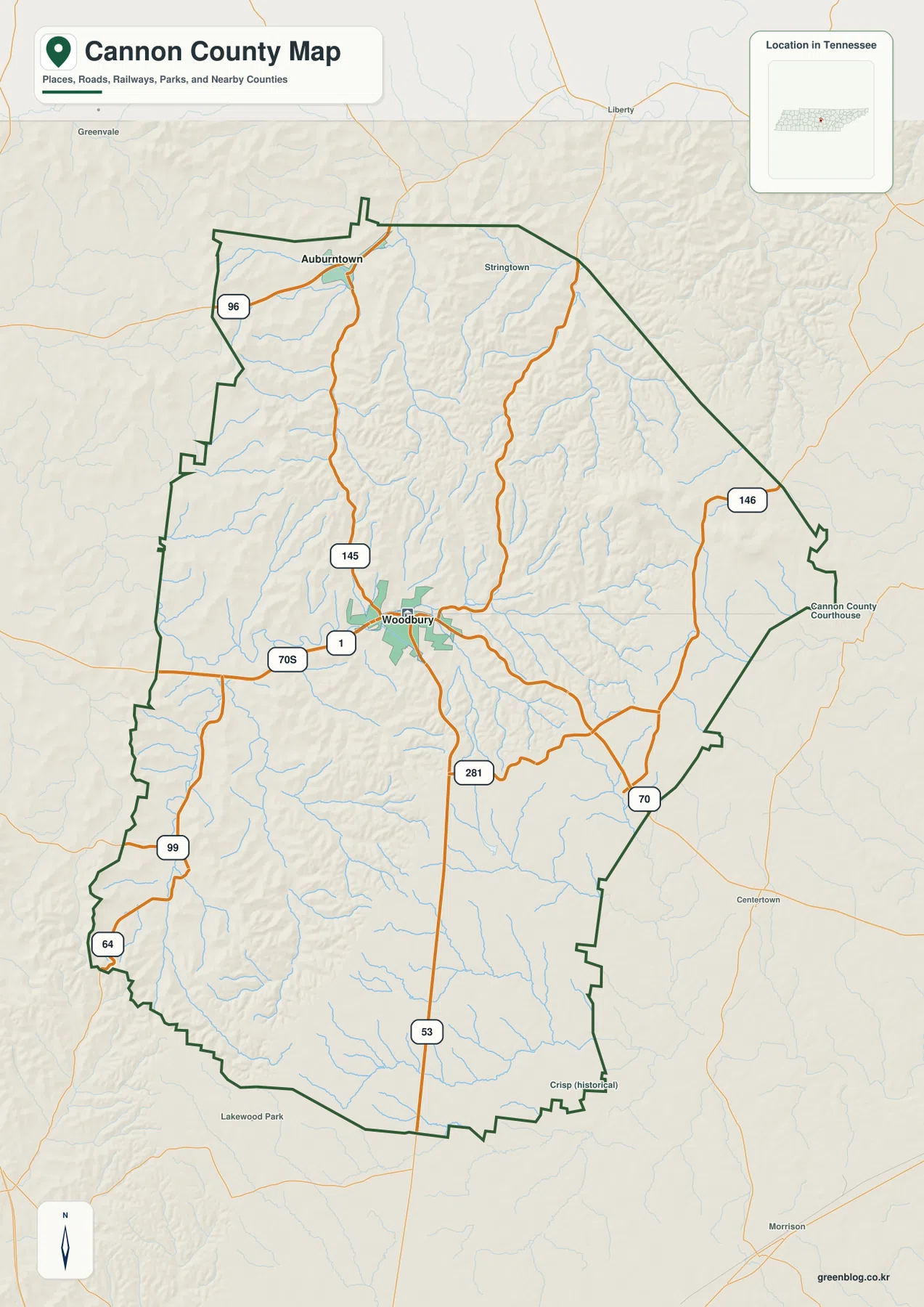
The surrounding labels help establish where Cannon County sits within Middle Tennessee. Wilson County is shown to the north, DeKalb County to the east, Warren County farther east and southeast, Rutherford County to the west, and Coffee County toward the southwest side. The eastern county line is long and diagonal, while the southern and western edges include more irregular bends. That shape matters when a road or creek approaches the border, because a nearby label may belong to a neighboring county even when it looks visually close to Woodbury.
Woodbury has the strongest concentration of mapped road connections. From there, the county can be divided into several easy-to-follow directions: north toward Route 145 and Auburntown, east toward Route 146 and the DeKalb County side, southeast toward Routes 70 and 281, south along Route 53, and southwest toward Routes 99 and 64. For a printed reference sheet, marking these directions is often more useful than trying to add every local road, because the major routes create a clear framework for the rest of the map.
Woodbury and Auburntown show the settlement pattern
The city map isolates the two ranked places shown most prominently in the county. Woodbury is marked in the center, while Auburntown sits near the northwestern side. The CITY INDEX printed at the bottom lists Woodbury at 2,774 and Auburntown at 318. Even without treating those figures as a complete picture of where every resident lives, the contrast makes the settlement pattern easy to grasp: Woodbury is the dominant named center, and Auburntown provides a second anchor for the northern part of the county.
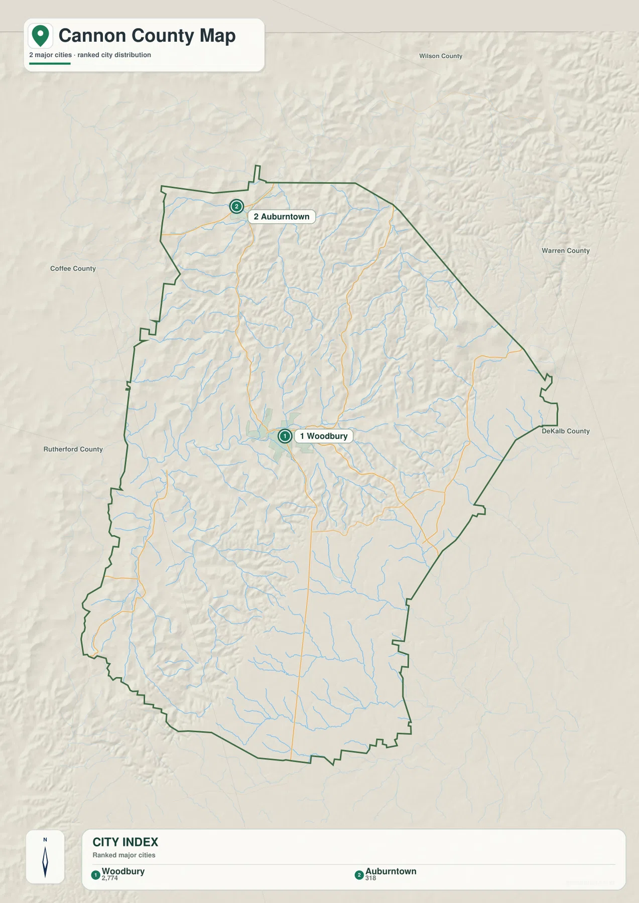
The space between those two labels is not empty country in a literal sense. The map is designed to emphasize major place names, while the shaded terrain and stream network reveal a much more intricate landscape between them. Woodbury sits where several roads and valleys converge, whereas Auburntown is tucked into the hillier northwestern section. Small communities, rural homes, and local roads may not receive the same visual emphasis, so this map works best as a county overview rather than a directory of every settlement.
Woodbury and Auburntown can also serve as two fixed points when the map is printed. Woodbury places the viewer in the central valley where US 70S, Route 145, and Route 53 meet, while Auburntown identifies the hillier northwest near the Wilson County side. Once those two places are marked, the outer roads make more sense because each can be followed from a known settlement toward a specific edge of Cannon County. That approach keeps the settlement map focused on local geography instead of turning it into a general list of uses.
East Fork Stones River and the branching creek network
The water map gives Cannon County a very different appearance. East Fork Stones River is the most prominent named waterway, entering from the east, crossing the central part of the county near Woodbury, and continuing toward the western boundary. A dense web of smaller streams joins it from the north and south. The large number of narrow drainage lines explains why the terrain looks deeply divided even where there is no large lake or broad river shown on the page.
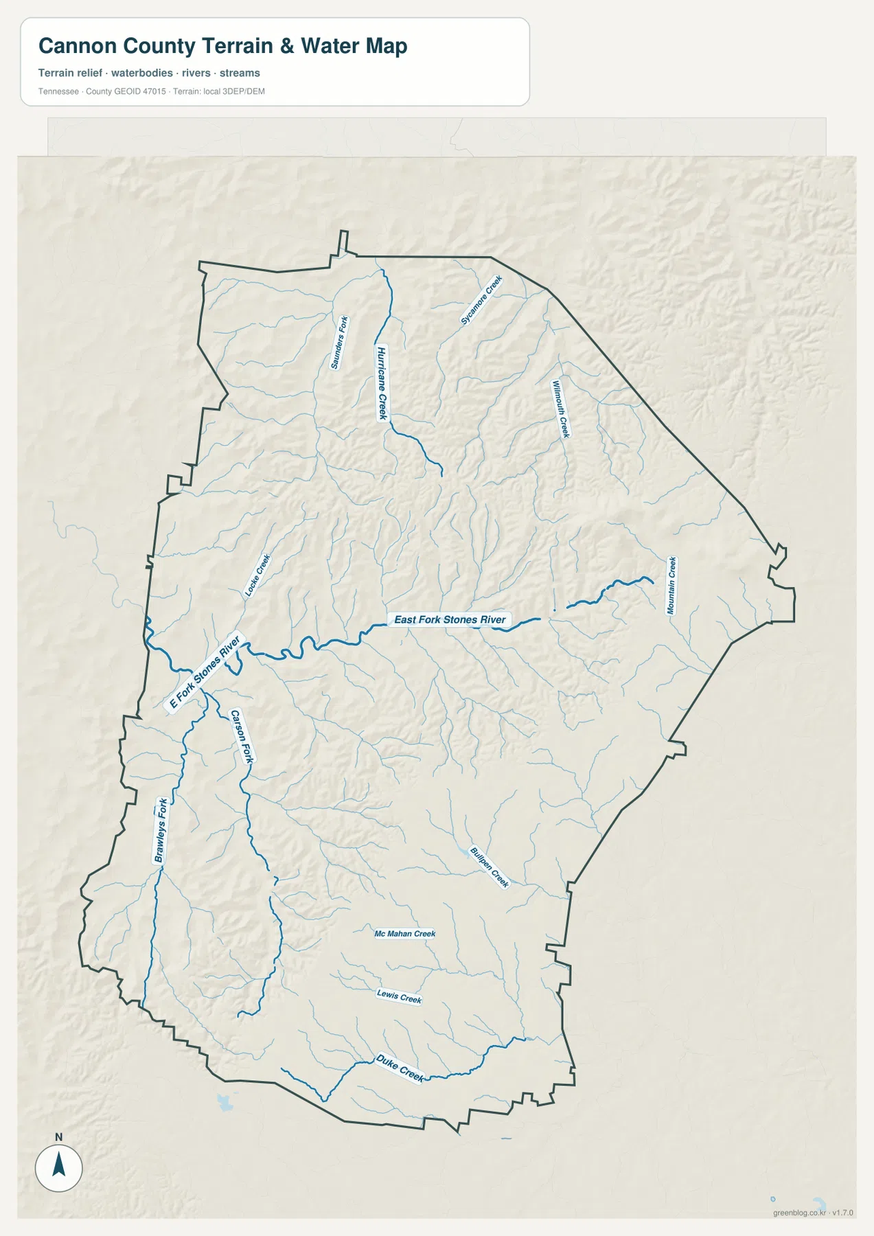
Several tributaries are labeled clearly enough to use as regional reference points. Hurricane Creek descends through the north-central area, while Sycamore Creek and Williams Creek appear farther east. Carson Fork runs south of Woodbury and connects with the broader drainage network. Mountain Creek is labeled toward the east, and Mc Mahan Creek, Lewis Creek, and Duke Creek appear in the southern part of the county. The important pattern is not the number of names but the way the tributaries repeatedly occupy the low ground between ridges.
This image should not be interpreted as a flood map, a boating chart, or a parcel-level water boundary. Its value is in showing the county’s drainage structure. A road may appear close to a destination on the general map but still have to follow a valley or reach one of the available stream crossings. Around Woodbury, where roads and waterways meet in the same central zone, that relationship is especially easy to see. For current bridge conditions, closures, or flood information, a live transportation or emergency source is more appropriate.
High ground in the east and lower valleys through the center and west
The elevation map makes the county’s relief unmistakable. Its legend shows an actual range from about 178 meters to 636 meters, with a mean near 305 meters. The highest colors cluster most strongly in the east-central part of the county, and additional ridges continue across the north. Lower green areas extend through much of the west and central valleys. This is a substantial change in height within a relatively compact county, which helps explain the close spacing of ridges and streams on the other maps.
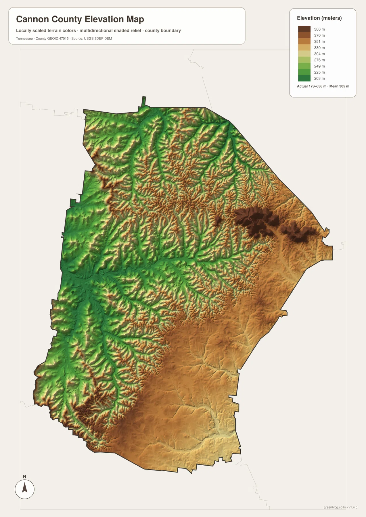
The elevation pattern matches the water map in a useful way. Streams occupy the lower channels between narrow ridges, so the drainage lines often look like a fine network cut into the shaded surface. The central and western side contains many green valley corridors, while the east-central high ground rises sharply above them. In the south, the colors are generally less extreme than the highest eastern area, but the surface is still broken by ridges and small valleys rather than forming one broad flat plain.
Because the surface is generalized for county-scale viewing, it should not be used as a survey or engineering elevation source. Its purpose is comparison. It clearly answers questions such as which side of Cannon County is higher, where the main low corridors extend, and why a waterway or road may bend through a valley instead of following a straight line. For those questions, the contrast between the dark eastern high ground and the greener western valleys is more useful than a long table of elevation values.
Where Woodbury, river valleys, and high ground meet
The same central valley appears repeatedly when the images are compared. Woodbury sits where several numbered roads meet, East Fork Stones River passes through the nearby low ground, and the elevation colors remain lower there than across the east-central ridges. Auburntown adds a second point of reference in the northwest, where smaller valleys and ridges crowd closer together. Those repeated locations connect the maps without requiring every road, creek, and contour to be drawn on one crowded image.
The northwestern part of Cannon County provides a good example. Auburntown is relatively close to the northern edge, but the surrounding terrain is cut by ridges and tributaries. Routes approaching that area therefore matter more than a simple straight line from Woodbury. The eastern side is different again: Routes 146 and 70 approach a higher, more rugged landscape near the DeKalb and Warren County sides. Southward, Route 53 and Route 281 pass through another set of valleys and ridges. These differences are visible without adding speculative travel times or route claims that the static maps cannot support.
A printed county map can be built around a specific Cannon County question rather than a fixed presentation formula. A road-oriented copy might begin at Woodbury and trace US 70S toward the Rutherford and DeKalb sides before adding Routes 145 and 53. A physical-geography copy can instead follow East Fork Stones River through the center and compare its tributary valleys with the higher eastern terrain. Keeping those two tasks on separate pages preserves the road labels and stream names that would otherwise compete for attention.
Match the map to the Cannon County feature
Choose the image by the Cannon County feature you need to explain. The county map keeps Woodbury, the numbered highways, and neighboring county lines together, which makes it the strongest reference for regional orientation. The city image strips the view back to Woodbury and Auburntown, while the water image brings East Fork Stones River, Hurricane Creek, Carson Fork, and the smaller valley streams forward. When the question is why the eastern side looks rougher or why roads bend through valleys, the elevation map gives the clearest answer by separating the high east-central ridges from the lower central and western corridors.
If the JPG files are printed for annotation, keeping an untouched original makes later comparisons easier. On a road copy, Woodbury, Auburntown, US 70S, Route 145, and Route 53 are enough to establish the main directions before smaller routes are added. On a terrain copy, tracing East Fork Stones River first and then marking Carson Fork, Hurricane Creek, and the high east-central ridges creates a very different but equally specific picture of Cannon County. The important point is to preserve the local labels that matter to the explanation instead of covering the page with unrelated notes.
Frequently Asked Questions
Where are Woodbury and Auburntown on the map?
Woodbury is near the center of Cannon County and is the main road and settlement reference on the maps. Auburntown lies to the northwest, closer to the northern county edge. Marking both places first makes it easier to distinguish the central county from the northwestern corner and to relate the area to Wilson and Rutherford counties.
How does East Fork Stones River cross Cannon County?
On the water map, East Fork Stones River runs from the eastern side through the central area near Woodbury and then continues toward the western boundary. Tributaries such as Hurricane Creek and Carson Fork connect with the broader drainage network, making the river a useful reference for understanding the county’s central valleys.
What stands out on the Cannon County elevation map?
The strongest contrast is between higher terrain in the east-central part of the county and lower valley corridors through much of the center and west. The legend shows an approximate countywide range of 178 to 636 meters with a mean near 305 meters. The map is intended for regional comparison, not for survey-grade elevation measurements at a specific property.
Map File Information
The download contains the same county, city, water, and elevation maps shown on this page as four high-resolution JPG files in an A3-format ZIP. They are suitable for printing, classroom handouts, presentations, and personal annotation.
- Included Files: county map, city map, water map, elevation map
- File Type: ZIP containing four high-resolution JPG files
Related Maps
- Carter County Tennessee map | Watauga River and Roan Mountain
- Bedford County Tennessee Map
- Bledsoe County Map
Sources and references
- Tennessee State Library and Archives – Cannon County fact sheet for county background and historical reference
- Tennessee Department of Transportation – Cannon County map for road and place reference
- U.S. Census Bureau TIGER/Line for county boundary and geographic data
- USGS National Hydrography for stream and drainage reference
- USGS 3D Elevation Program for elevation and terrain reference
Green Map creates custom-edited map images using open geographic data sources such as geoBoundaries, Natural Earth, OpenStreetMap, and government open data. These maps are edited visual materials, not raw data files, and are provided for education, documents, presentations, and graphic reference.