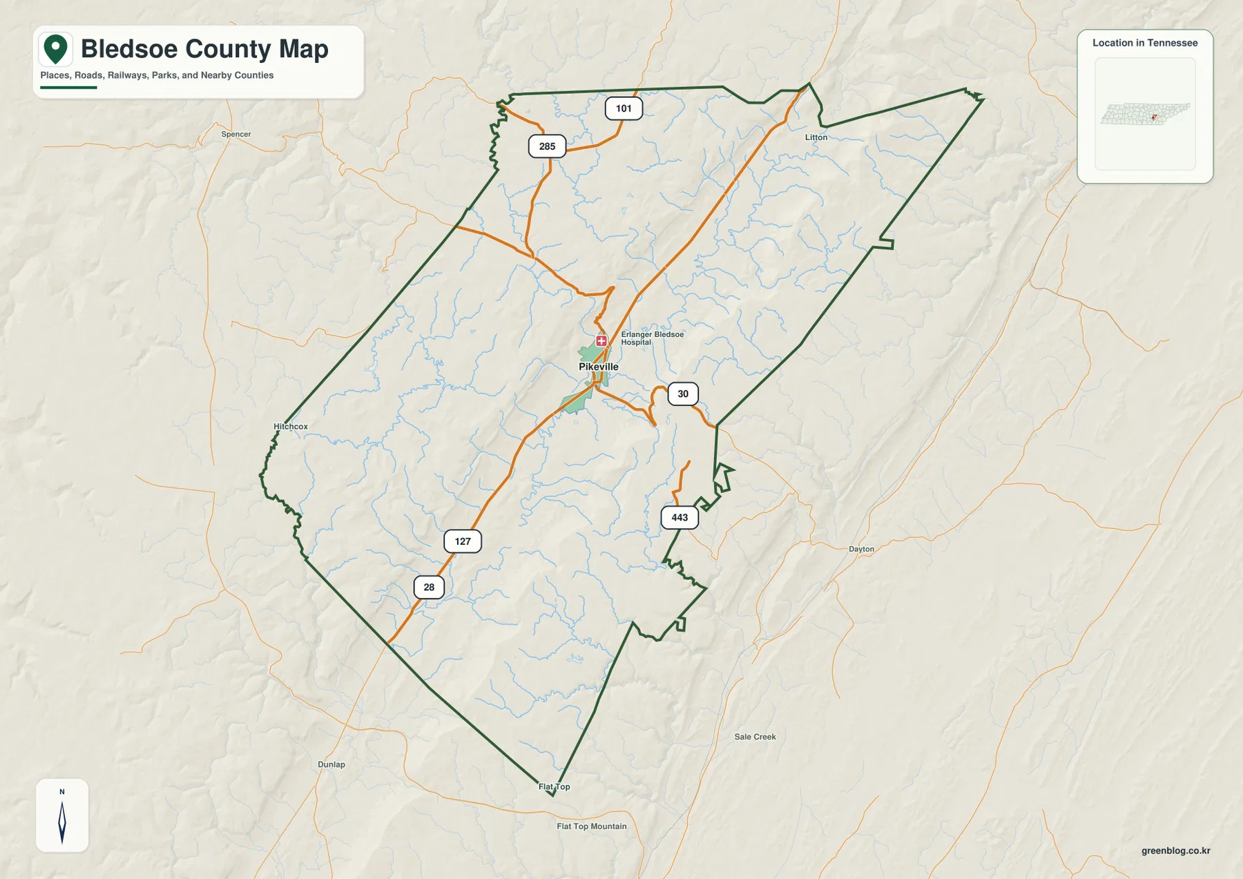
Bledsoe County is easiest to understand when Pikeville and the long central valley are used as the first reference points. On the general county map, Pikeville sits near the meeting of the roads labeled 127 and 30. On the water map, the Sequatchie River follows the same broad interior lowland, while the elevation map shows much higher ground rising on both sides. This page uses the four maps actually supplied in the package—county, city, water, and elevation maps—to explain those relationships. The same maps are also available together as high-resolution A3 JPG files for download.
The county does not look like a flat block organized around a single road grid. The 127 corridor follows the interior through Pikeville, but other numbered roads break away toward different edges: 30 runs east from the Pikeville area, 28 approaches the southwest, 443 appears to the southeast, and 101 and 285 serve the northwestern side. That pattern becomes more meaningful when it is compared with the river and elevation layers. The central route network occupies the lower valley, while many side roads must reach into or across substantially higher ground.
Each supplied map removes some information and emphasizes something else. The general county map is the best starting point for boundaries, roads, and named places. The city map simplifies the page to show Pikeville as the ranked city and gives a clean view of neighboring counties. The terrain-and-water map labels the Sequatchie River, several creeks, Tollet Lake, and Brushy Pond. The elevation map then explains why the water and roads tend to occupy the long green lowland between higher ridges. Reading them together provides a clearer picture than trying to force every detail onto one image.
Table of Contents
Pikeville and the road pattern through a long, narrow county
Pikeville is the most useful orientation point on the general map. The Erlanger Bledsoe Hospital label appears beside the city, and road 127 approaches from the southwest, passes the Pikeville area, and continues north. Road 30 heads east from the same central section, while 443 is labeled on the southeastern side. Farther northwest, 101 and 285 mark separate approaches, and 28 is visible in the southwest. The result is not a uniform grid: several routes use the central valley, while others branch toward the higher sides of the county.
The county outline also changes noticeably from north to south. The northern end is comparatively broad, the eastern line includes several sharp bends, and the southern end narrows into a different shape. Small labels help with orientation at the edges. Litton appears near the north, Hitchcock sits close to the western side, and Flat Top is labeled at the southern tip. These names should not be treated as equal-size cities, but they are useful landmarks for understanding how far the county extends beyond Pikeville.
The surrounding county labels provide another useful frame. Cumberland County and Grundy County are shown to the north, Rhea County and Meigs County to the east, Hamilton County and Sequatchie County to the southwest, and Van Buren County to the west. Because roads, streams, and ridges continue across administrative lines, a place close to the green outline should be checked against the boundary rather than assigned to Bledsoe County simply because it is visually nearby.
What the city map says by emphasizing only Pikeville
The city map takes a deliberately simple approach. Its CITY INDEX contains one ranked city, Pikeville, with the number 2,319 printed below the name. That figure belongs to the map’s city-ranking display; it should not be expanded into a claim about the county’s entire current population or every settlement that appears on other maps. The useful point is geographic: Pikeville lies in the central interior, close to the main road junction and the low valley that also contains the Sequatchie River.
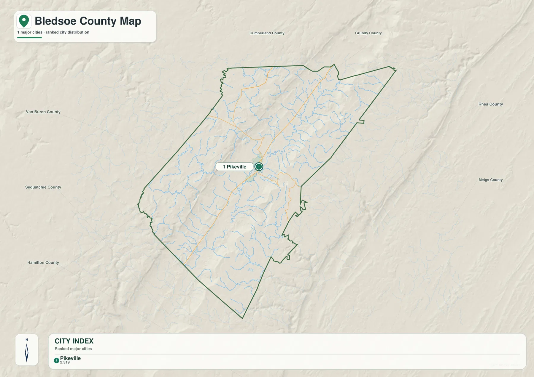
This simplified view is useful when a presentation or worksheet does not need every small place name. Pikeville can be marked first, and the neighboring county names can then establish direction without clutter. When more detail is needed, the general map adds labels such as Litton, Hitchcock, and Flat Top and shows how roads leave the Pikeville area toward different edges. In that sense, the city map is not a reduced replacement for the other maps; it is a clean location index that can be paired with them.
Comparing the city map with the elevation layer also reveals something important about settlement location. Pikeville is positioned near the long green band of lower terrain rather than on the highest brown ridges. The water map places the Sequatchie River in the same broad corridor, and the county map brings road 127 through it. These separate images all point to the same physical relationship without requiring a technical terrain analysis: the county’s main urban and transportation reference lies in the valley between much higher ground.
The Sequatchie River and a network of creeks in the central valley
The Sequatchie River is the dominant named watercourse on the terrain-and-water map. It enters the southern part of the county and follows the central lowland through much of the interior. Numerous tributaries descend toward it from both sides. Cane Creek and College Creek are labeled west of the main river, while Skillern Creek, Crystal Creek, and Roaring Creek approach from the east. Farther north, Bee Creek and Beaverdam Creek are named; in the south, Cannon Creek, Pond Creek, and Heel Creek add more examples of the smaller valleys draining the uplands.
Tollet Lake is labeled in the north-central part of the water map, and Brushy Pond appears in the south. The map supports using them as location references, but it does not by itself establish detailed information about shoreline access, water level, or recreation rules. Their value here is visual. Tollet Lake sits among a dense group of streams near the upper part of the central drainage, while Brushy Pond provides a named water feature near the southern end of the county.
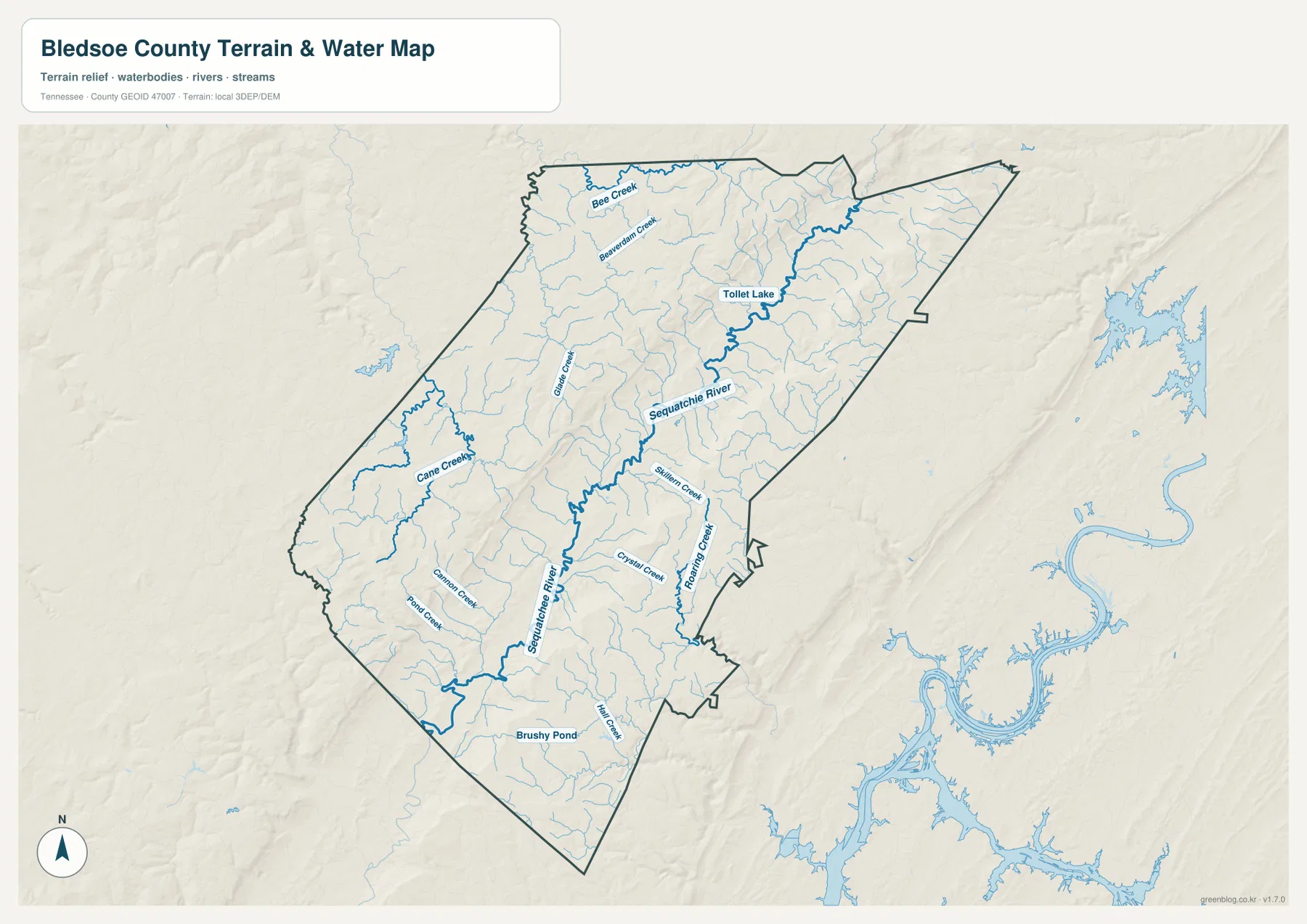
The many thin blue lines are just as important as the larger labels. They show that the county is cut by numerous small drainage valleys rather than by a single river channel alone. This explains why the terrain looks so broken on the shaded-relief base and why a road heading toward the eastern or western sides may bend around slopes and cross several small streams. The water map is therefore useful not only for finding river names but also for understanding how the interior is divided into a main valley and many side valleys.
Road 127 and the Sequatchie River are especially helpful when the road and water maps are compared side by side. Both occupy the long interior corridor through the county, although they do not follow the same line at every point. The relationship gives a practical starting point for reading the map: locate Pikeville, find the river, then trace the main north-south road before looking at side creeks and roads that climb toward the higher margins.
From about 217 to 811 meters: a low valley between much higher ground
The elevation map makes the county’s relief immediately visible. Its legend reports an actual elevation range of about 217 to 811 meters and a mean of 488 meters. The long central strip is dominated by green shades, indicating lower terrain, while yellow, orange, and brown areas rise on both sides. The eastern high ground forms a particularly clear north-south band, and the western side contains a broad elevated surface cut by many smaller valleys.
The central valley is not perfectly flat. Shaded relief reveals small ridges and channels within the lower green area, and the width of the lowland changes along the county. On the east side, the transition from green valley floor to higher brown terrain is often sharp. On the west, high ground occupies a broader area and is dissected by numerous drainage lines. Those differences help explain why a simple straight-line measurement between two places can hide substantial changes in slope and route choice.
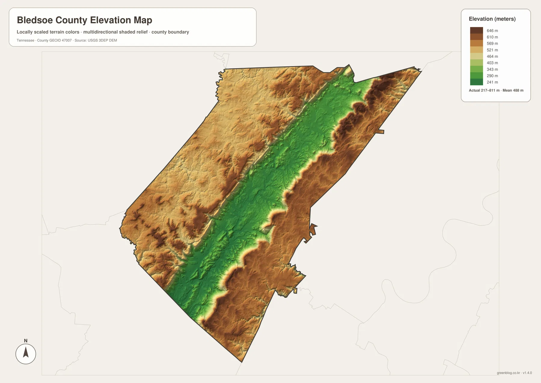
The elevation layer becomes more informative when it is read with the water map. The Sequatchie River follows the lower interior, and many tributaries begin on higher yellow or brown ground before descending toward the central valley. That correspondence is visible without adding features that are not in the package. The map is suitable for county-scale comparison, but the displayed colors and relief should not be substituted for a survey-grade elevation measurement at a specific property or construction site.
Choosing the map that matches the question
Use the general county map when the question is about roads, boundary shape, or the position of Pikeville within the county. Starting with 127 and 30 makes it easy to add the northwest routes 101 and 285, the southwest road 28, and 443 in the southeast. Use the city map when the goal is much simpler: showing Pikeville in relation to the county outline and the neighboring counties without filling the page with smaller labels.
The water map is the better choice for the Sequatchie River and named tributaries. It lets a reader compare Cane Creek, College Creek, Skillern Creek, Crystal Creek, Roaring Creek, Bee Creek, and Beaverdam Creek with the main river and find Tollet Lake and Brushy Pond. When the question is why those streams and roads occupy certain corridors, the elevation map adds the missing piece by separating the low central valley from the high eastern and western terrain.
For printed notes, it is often clearer to assign one task to each sheet. Mark destinations and road numbers on the county map, use the water map for river and creek labels, and reserve the elevation map for high and low terrain. The city map can remain uncluttered as a simple reference for Pikeville and the surrounding counties. This approach keeps annotations from covering the labels that make each map useful.
Why the neighboring county labels matter
Bledsoe County’s boundary is easier to place regionally when the names around it are visible. The city map shows Cumberland County and Grundy County along the north, Rhea County and Meigs County to the east, Hamilton County and Sequatchie County to the southwest, and Van Buren County to the west. Together, those labels show that Bledsoe County occupies an elongated position among several neighboring jurisdictions rather than an isolated block.
The boundary should be checked before using a nearby label as a county location. Road 30 runs from Pikeville toward the eastern edge, while 101 and 285 lead toward the northwest. Roads 28 and 127 provide different approaches in the southern half. A route may continue beyond the green county line, so the static county map is best used to establish the broad direction first and current transportation information should be used for exact driving conditions.
The same caution applies to natural features. Administrative lines stop at the county boundary, but the central valley, the river drainage, and the high ridges continue into surrounding areas. The elevation colors and stream lines should therefore be read as parts of a larger landscape that happen to be clipped to the Bledsoe County outline for this page. That distinction is useful when comparing this map with neighboring county maps later.
Frequently Asked Questions
How are Pikeville and the Sequatchie River related on these maps?
Pikeville lies in the central low valley, and the Sequatchie River follows the same broad interior corridor. The general map also brings roads 127 and 30 together around Pikeville. Comparing the county, water, and elevation maps shows that the county’s main urban and transportation reference is located in the lower valley between much higher terrain.
What elevation range is shown on the Bledsoe County map?
The elevation map reports an actual range of about 217 to 811 meters and a mean elevation of 488 meters. The central valley is shown mainly in green, while higher terrain on both sides shifts through yellow, orange, and brown. These values are useful for county-scale terrain comparison, not as a substitute for a precise surveyed elevation at a specific site.
Which named water features are easiest to find?
The Sequatchie River is the main named watercourse. The map also labels Cane Creek, College Creek, Skillern Creek, Crystal Creek, Roaring Creek, Bee Creek, Beaverdam Creek, and several additional tributaries. Tollet Lake is labeled in the north-central area and Brushy Pond in the south, giving useful reference points beyond the river itself.
Sources and Reference Material
- Tennessee State Library and Archives Bledsoe County fact sheet
- State of Tennessee Sequatchie watershed reference
- U.S. Census Bureau TIGER/Line boundary data
- USGS National Hydrography
- USGS 3D Elevation Program
Map File Information
The ZIP contains the A3 high-resolution JPG originals for the county map, city map, water map, and elevation map shown on this page. Use the JPG files when small road labels, creek names, or shaded-relief detail need to remain clear during printing or enlargement.
- Included Files: county map, city map, water map, elevation map
- File Type: ZIP containing four high-resolution JPG files
Related Maps
Green Map creates custom-edited map images using open geographic data sources such as geoBoundaries, Natural Earth, OpenStreetMap, and government open data. These maps are edited visual materials, not raw data files, and are provided for education, documents, presentations, and graphic reference.