Benton County is easier to understand when the long eastern shoreline is treated as part of the county’s basic shape rather than as background. Camden sits in the south-central part of the county where several important roads meet, while Big Sandy provides a second settlement reference much farther north. The eastern side follows the Kentucky Lake and Tennessee River water system for a long distance, and the interior is cut by many small creeks and wooded ridges. The maps on this page show those relationships at different levels of detail, and the same map set is available as high-resolution A3 JPG files in one downloadable ZIP.
The county outline is notably uneven on the water side. Lake arms push into the northwestern and eastern edges, while the western side includes much straighter boundary segments. Farther south, the eastern boundary bends around broad water and low ground before narrowing again near the county’s southeastern end. If you first locate Camden, then Big Sandy, Holladay, and the Kentucky Lake shoreline, the tall north-to-south form of Benton County becomes much easier to recognize.
Each supplied map adds a different kind of detail without changing the geographic story. The county map combines named places, roads, streams, and neighboring areas. The city map strips the view down to the two ranked settlement labels, Camden and Big Sandy. The terrain-and-water map makes the eastern reservoir corridor and named creeks stand out, while the elevation map separates low river valleys from higher ridges. Reading them together explains why roads and communities occupy the positions shown on the page.
Table of Contents
Camden at the center of the county road network
On the general county map, Camden is the most useful starting point. It is not the geometric center of the outline, but several major routes converge around it. US 70 runs east and west through the Camden area, and the US 641 corridor provides a strong north-south connection. From this junction, roads extend toward Eva and the eastern water edge, toward Carroll County to the west, and toward Holladay in the southern part of Benton County. That pattern makes Camden the clearest reference for comparing road directions across the map.
North of Camden, the route marked 69A continues toward Big Sandy. Route 147 is visible farther north near the lake-facing part of the county. In the south, the map also labels 69, 641, 191, and 192, while I-40 clips the southeastern portion of the county. These routes do not form a uniform grid. They branch, bend, and narrow as they pass between creek valleys, higher ground, and the large body of water along the eastern side.
The water-facing boundary is the feature that gives Benton County much of its distinctive outline. Kentucky Lake, part of the Tennessee River system, follows the eastern side for many miles. Near Big Sandy, branches of the lake also create an irregular northwestern edge. South and east of Camden, the boundary curves around broad water before turning toward the narrow southeastern end. The contrast with the straighter western boundary is obvious and helps explain why an ordinary rectangular county sketch would be misleading here.
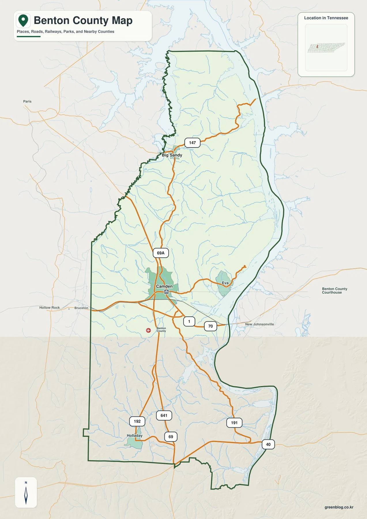
Neighboring counties provide another useful orientation check. Carroll County and Henry County lie to the west and northwest, Decatur County is to the southwest, and Perry, Houston, and Humphreys counties appear on the eastern side of the wider map. Because water separates parts of these areas, the nearest visible place across the lake is not automatically inside Benton County. The green county boundary should be checked before assigning a shoreline road, stream mouth, or community label to the county.
Why Camden and Big Sandy matter as separate settlement references
The city map intentionally emphasizes only two ranked places: Camden and Big Sandy. Camden is ranked first in the map index and Big Sandy second. Their positions are more informative than a long list of small labels because they show how far the county stretches from its south-central administrative and road center to a northern settlement near the water. The distance between their map positions also makes the elongated shape of Benton County immediately apparent.
Camden is surrounded by a denser cluster of mapped roads, while Big Sandy sits in a simpler northern network close to branching lake water. Small streams fill much of the space between the two. For that reason, a straight line from Camden to Big Sandy does not describe the actual travel pattern very well. The useful question is where the north-south roads run, how the route bends around drainage valleys, and whether a water arm forces travel toward a limited crossing or a longer inland approach.
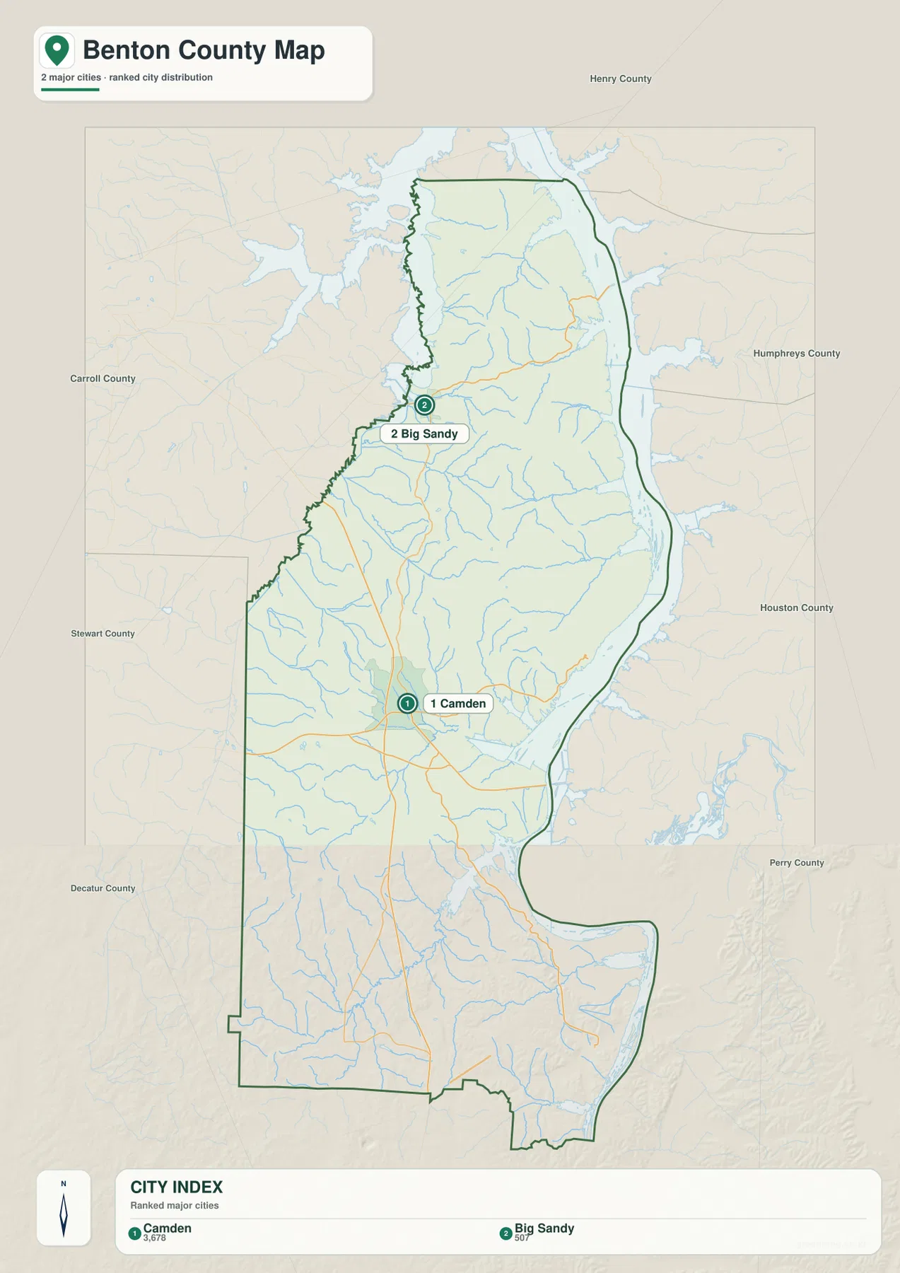
Eva and Holladay remain useful even though they are not emphasized in the ranked city panel. Eva marks the direction from Camden toward the eastern water edge, while Holladay provides a reference for the broad southwestern interior. Taken together, Camden, Big Sandy, Eva, and Holladay show that Benton County is not organized around one compact urban center. Its named places are separated by creeks, ridges, roads, and long stretches of rural land.
The population figures in the supplied county material add scale but should not replace the settlement map. The 2020 census counted 15,864 residents, and the July 2025 Census Bureau estimate is 16,183. Those values belong to different reference dates and should be labeled that way. They describe the county as a whole, but they do not show how residents are divided between Camden, Big Sandy, smaller communities, lakeside areas, and rural roads. The city and road maps are better for understanding that geographic arrangement.
Kentucky Lake, the Tennessee River, and a county full of creeks
The terrain-and-water map makes the eastern water corridor the dominant feature. The package title describes the eastern shoreline in a Kentucky Lake context, while the supplied water map places a Tennessee River label in the central-southern part of the same broad eastern water corridor. Rather than forcing those labels into one name, this page follows what the materials actually show: wide water along the county edge continuing northward with large embayments and narrower branches extending toward the interior. Large embayments and narrower branches extend toward the interior in several places, particularly around the northern and central sections.
The interior drainage is much more detailed than the general road map suggests. Lick Creek and Ramble Creek are labeled in the north. Sulphur Creek, Rushing Creek, and North Fork Harmon Creek appear farther south through the central part of the county. Burnside Creek, Cypress Creek, and Cane Creek are visible around the middle and south-central area, while Birdsong Creek, Seventeen Creek, and Eagle Creek help define the drainage farther south. These named streams reveal a landscape made of many short valleys feeding the larger eastern water system.
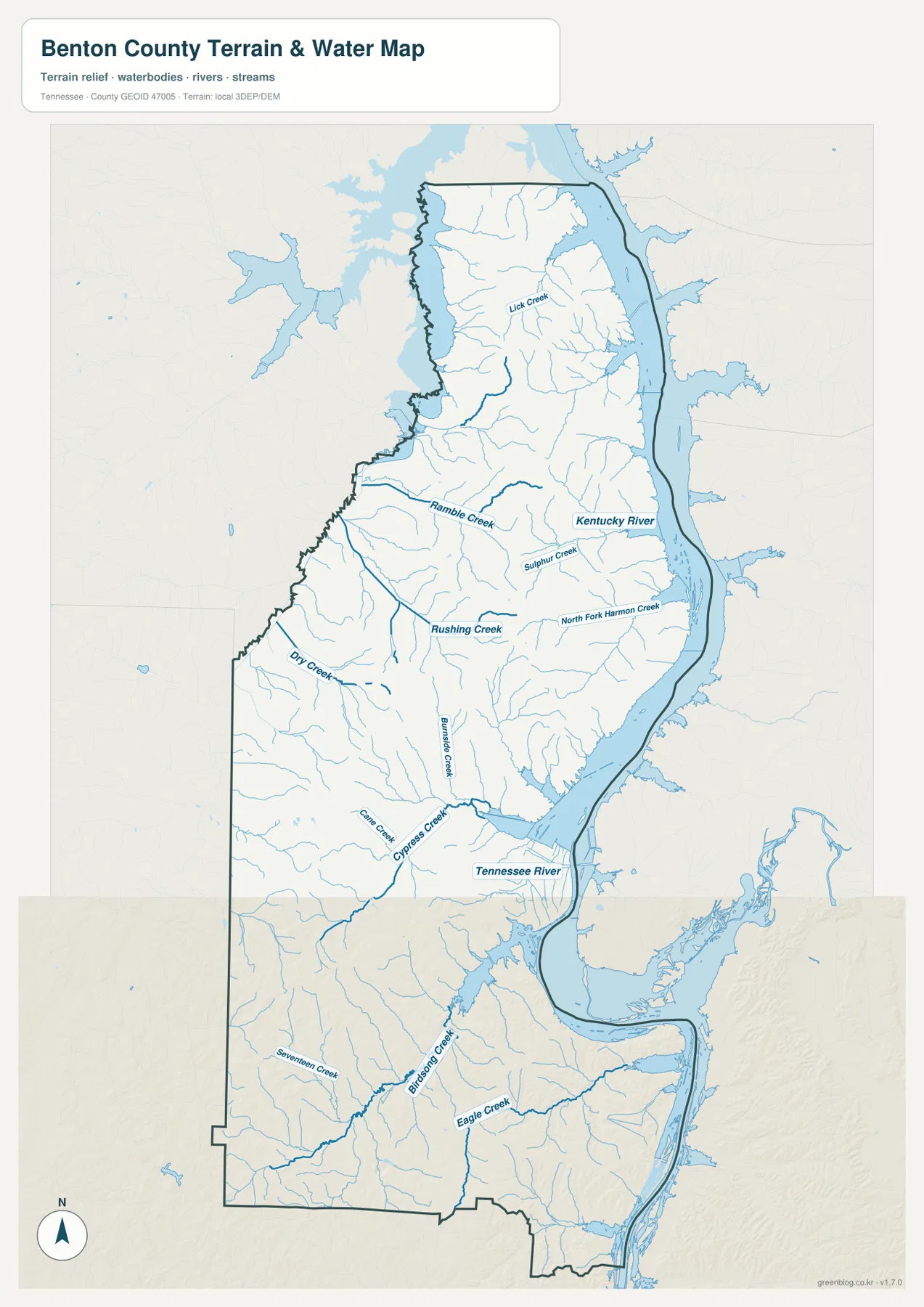
Camden lies close to several small drainages but west of the broad river-reservoir edge. Around Big Sandy, water approaches from more than one direction and the usable land narrows in places between lake branches. In southern Benton County, the main water body sweeps through a broad curve, and several tributaries meet lower terrain before reaching it. This arrangement helps explain both the curved county boundary and the way some roads concentrate in particular corridors instead of running directly east-west.
The Gazetteer figures included with the county package list 394.3 square miles of land and 41.9 square miles of water. That water area is easy to understand when the eastern map edge is viewed at full county scale. The number does not, however, provide a current lake level, safe boating depth, flood limit, or bridge condition. The water map is best used for county-scale orientation and for locating named drainage features before checking current information from the responsible agencies.
A 67–204 meter landscape shaped by valleys and ridges
The elevation map shows that Benton County is not simply a flat lakeshore landscape. Its legend reports an actual elevation range of about 67 to 204 meters, with a mean near 143 meters. The lowest green areas follow Kentucky Lake, the Tennessee River corridor, and the major creek valleys. Yellow, tan, and brown ridges rise between those drainages, producing a textured interior that becomes especially noticeable in the central-eastern and southeastern parts of the county.
North of Big Sandy, narrow ridges and branching valleys repeat across the map. Through the central section, creek bottoms cut through higher ground on the way toward the eastern water. The southern half also contains extensive rolling relief, with several darker high areas near the southeastern and southwestern interior. The result is a county where two places can appear close on a small road map but still be separated by a series of valleys and ridges.
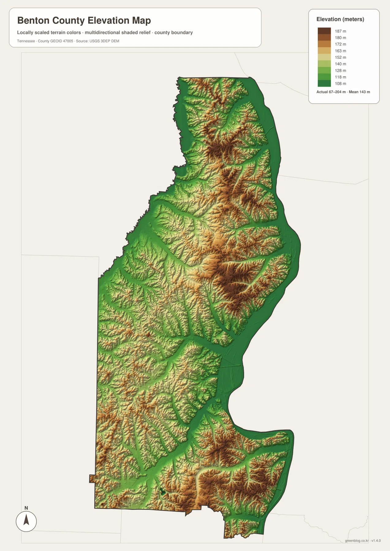
The color surface is designed for regional comparison, not parcel surveying or engineering work. A specific property may have a local slope or elevation difference that is too small to resolve at this county scale. For detailed measurements, the underlying USGS elevation products are the appropriate next step. On this page, the value of the elevation map is visual: it connects the creek network to the low valleys and shows why road alignments often follow lower ground or curve around steeper ridges.
Choosing the map that answers the immediate question
For basic orientation, the general county map should come first. Locate Camden, follow US 70 and the US 641 corridor, then check Big Sandy to the north, Holladay to the southwest, and Eva toward the eastern shore. This view keeps boundaries, roads, streams, and surrounding places in one frame. It is the most practical choice when the task is to understand where a destination sits within Benton County rather than to study one physical feature in detail.
The ranked city map is better when the goal is a clean comparison between Camden and Big Sandy. The water map is the strongest choice for tracing the Tennessee River and Kentucky Lake edge or locating named creeks such as Rushing Creek, Cypress Creek, and Birdsong Creek. The elevation map adds the missing vertical dimension, showing which creek bottoms are low and where the ridges rise between them. Switching maps according to the question keeps the page readable and avoids forcing every label onto one crowded image.
For a printed working copy, the maps can also be divided by task. Mark planned roads or community names on the county map, make shoreline or tributary notes on the water map, and use the elevation map to flag areas where relief may affect access. The city map works well for a simple north-south comparison between the two ranked settlements. Keeping one clean copy of each image and annotating duplicates is useful when the same base map will be reused for different projects.
The downloadable JPGs correspond to the same map topics as the page previews, but they preserve more detail than the smaller WebP display images. Road numbers, creek names, and shaded relief are easier to inspect at the original size. If the files will be edited, it is sensible to keep an untouched original and make notes on a duplicate so the clean map remains available for later printing or reuse.
What the four views reveal about Benton County as a whole
Benton County cannot be summarized by Camden alone. Camden is the administrative and road reference, Big Sandy represents a separate northern settlement area, Eva points toward the eastern shore, and Holladay helps orient the broad southwestern interior. The Kentucky Lake and Tennessee River system creates a long water boundary on one side, while multiple creek valleys divide the interior. That combination produces a county whose travel routes, settlement pattern, and outline are all strongly influenced by water and relief.
I-40 appears on the map, but it touches only the southern part of the county and should not be treated as the organizing road for every local trip. US 70, the US 641 corridor, 69A, and other state routes are much more visible in the connections between Camden and the surrounding areas. Around the lake, a destination that looks nearby across water may require an inland approach or a specific crossing. Current navigation and transportation information should therefore be used for actual driving decisions.
The water and elevation maps also have clear limits. The water view is not a flood-risk map, nautical chart, or legal shoreline survey, and the elevation surface is not a replacement for site-level measurements. Their strength is comparison at the county scale. By matching low valleys with named creeks, then comparing those features with roads and settlements, the reader can see why the Benton County map looks the way it does rather than treating every layer as an unrelated image.
Frequently Asked Questions
Why are Camden and Big Sandy both important on a Benton County map?
Camden is the county seat and the main road reference in the south-central part of Benton County, while Big Sandy is a major northern settlement close to branching lake water. Showing both makes the county’s long north-south form much easier to understand. It also prevents the map from suggesting that all local activity is concentrated around Camden when the northern part of the county has its own settlement and access pattern.
Is the large eastern water body the Tennessee River or Kentucky Lake?
The package title uses Kentucky Lake for the Benton County shoreline, while the supplied water map includes a Tennessee River label in the central-southern section. Because the attached materials use both labels, this page keeps that distinction instead of inventing a more precise naming rule. For map reading, the important point is the long eastern water edge and the creeks that drain toward it.
What does the elevation map say about Benton County terrain?
The supplied elevation legend shows an actual range of roughly 67 to 204 meters and a mean of about 143 meters. Lower ground follows the main lake, river, and creek valleys, while higher ridges occupy much of the interior. The map is appropriate for seeing broad relief differences, but a parcel, construction site, or engineering project requires more detailed elevation data such as the original USGS 3DEP products.
Map File Information
The ZIP contains the original high-resolution A3 JPG versions of the county, city, water, and elevation maps shown on this page. Use the JPG files when you need more detail for printing, layout work, or your own annotations.
- Included Files: county map, city map, water map, elevation map
- File Type: ZIP containing four high-resolution JPG files
Related Maps
Sources and references
- Tennessee State Library and Archives Benton County fact sheet
- Tennessee Big Sandy Wildlife Management Area
- U.S. Census Bureau TIGER/Line
- U.S. Census Bureau Benton County QuickFacts
- USGS National Hydrography
- USGS 3D Elevation Program
Green Map creates custom-edited map images using open geographic data sources such as geoBoundaries, Natural Earth, OpenStreetMap, and government open data. These maps are edited visual materials, not raw data files, and are provided for education, documents, presentations, and graphic reference.