Download the high-resolution A3 JPG ZIP for the Humphreys County Tennessee Map directly from this page; it contains the county, city, water, and elevation maps shown below. Waverly is the central hub, McEwen lies to the east, and New Johnsonville sits near the broad western water edge. Duck River and Buffalo River occupy low valleys in the western and southern half, while the eastern side rises into more extensive rolling ridges.
The county is easiest to understand by comparing the two directions out of Waverly. Travel west and the map moves toward New Johnsonville, broad water, and lower river terrain. Travel east toward McEwen and the landscape becomes more strongly dissected by ridges and narrow creeks. The road, water, and elevation layers all reinforce that contrast.
Table of Contents
Waverly sits between McEwen and the New Johnsonville water side
The city layer labels Waverly at 4,302 residents, New Johnsonville at 2,060, and McEwen at 1,806. The numbers provide a quick size comparison, but the placement is more useful for orientation. McEwen is east of Waverly, while New Johnsonville is west near the major water edge.
The connector lines show straight-line distance, not driving mileage. Waverly to McEwen is marked at about 8 miles, and Waverly to New Johnsonville at about 12 miles. Actual road travel can be longer, but the labels make it easy to compare the two outer city references on the same scale.
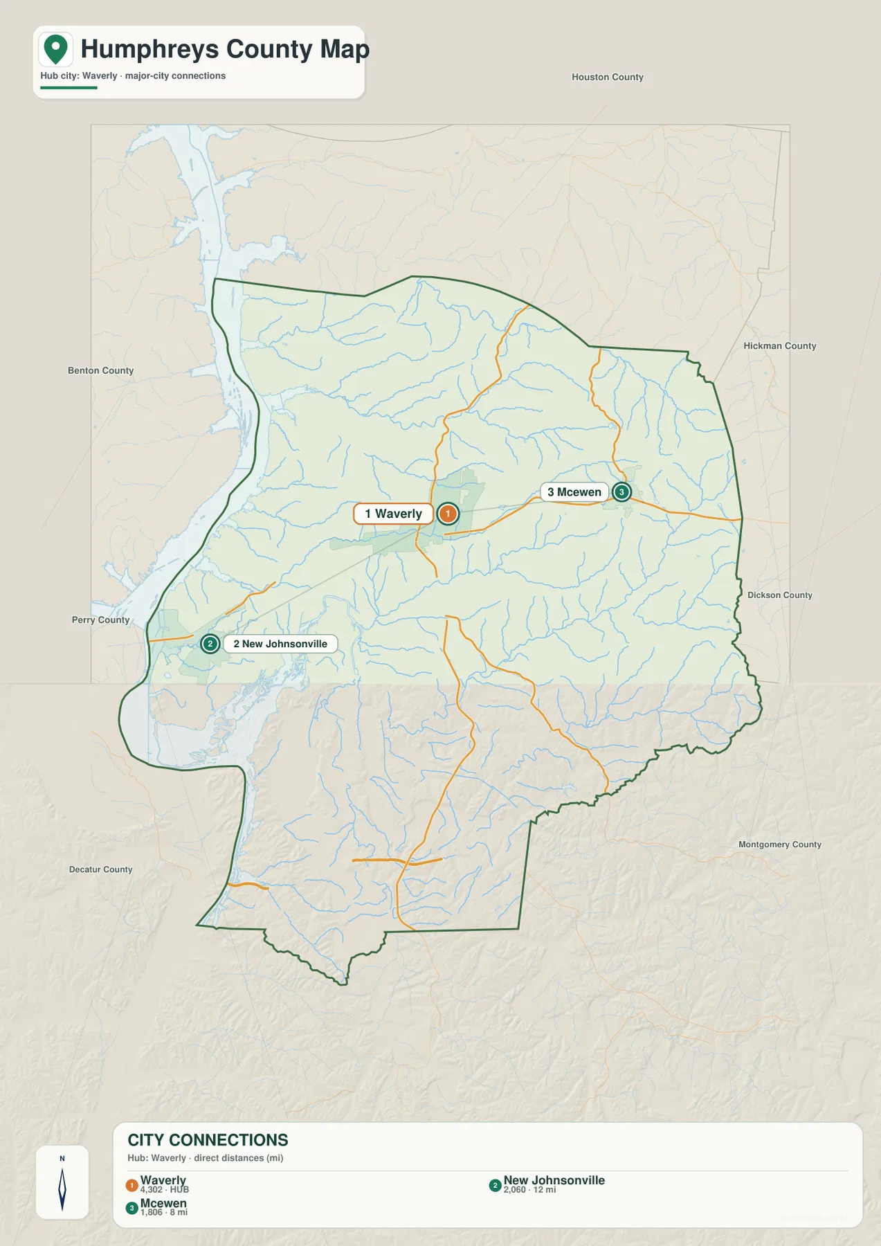
Several surrounding county names appear outside the outline, including Houston, Hickman, Dickson, Benton, and Perry. They provide broad orientation around Humphreys County, although labels visible outside the map should not automatically be treated as identical types of boundary relationships. For reading the county itself, Waverly and the two outer cities provide the clearest starting points.
Roads split at Waverly toward McEwen, New Johnsonville, and the southern hills
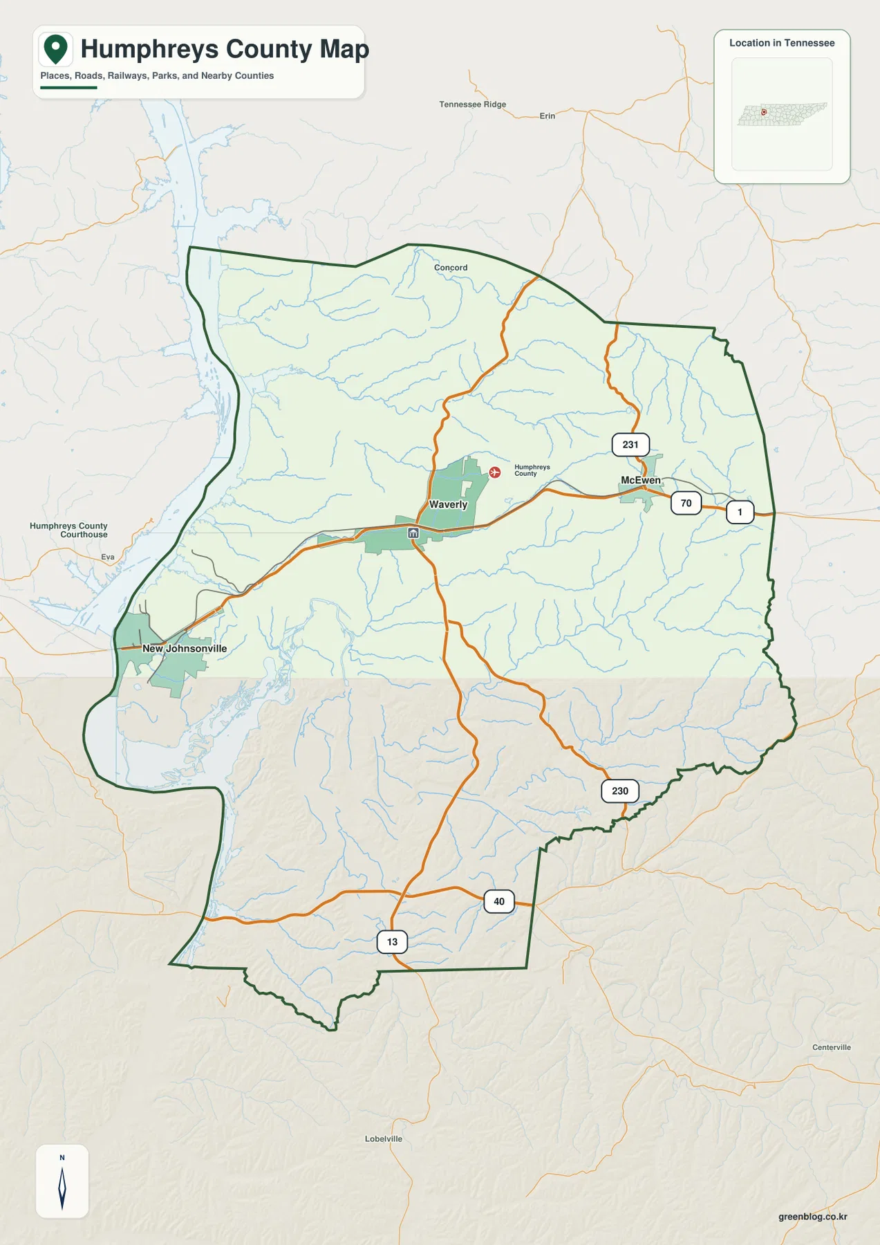
Route 13 is the clearest north–south line through the Waverly area. Eastward, Routes 70 and 1 are labeled near McEwen, and Route 231 extends into the northeastern part of the county. Together these lines establish the main central-to-eastern road pattern before smaller roads are considered.
The southern half includes Route 40 and Route 230, both useful for locating the lower part of the county. Roads in this area cross a landscape broken by creek valleys, so the base map shows more bends than a flat grid would. The elevation layer helps explain where the road follows a low passage and where it climbs across rolling ground.
West of Waverly, the road network approaches lower terrain and the New Johnsonville water side. Concord appears in the north and provides another useful outer place label. A practical reading method is to choose one of three directions from Waverly: east toward McEwen, west toward New Johnsonville, or south along Route 13 toward the lower county.
Duck and Buffalo river valleys create the low western and southern corridors
The broad western water area and the labeled Duck River Dewatering Area dominate the lower-left portion of the water map. Buffalo River approaches from the southwest, while Duck River crosses the southern interior toward the same general lowland. These large waterways correspond closely with the darkest green terrain on the elevation image.
Farther north, the drainage becomes more finely divided. Blue Creek crosses the central county, with Trace Creek, Little Richland Creek, and Big Richland Creek occupying neighboring valleys. Whiteoak Creek lies farther north and east, tracing a long low corridor through otherwise higher ground.
Hurricane Creek is prominent in the southeast, with Indian Creek, Tumbling Creek, and Turkey Branches adding smaller valleys nearby. Whery Lake sits close to the Buffalo River side, while Johnson Pond provides a smaller northern reference. These named waters make it easier to match individual valleys on the water map with the ridges visible on the elevation layer.
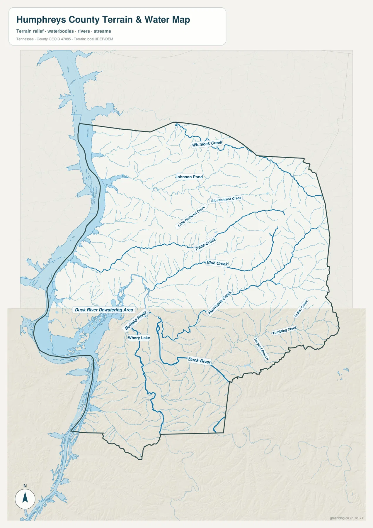
This layer is a geographic reference rather than a live water-conditions product. Reservoir or river stage, boating access, and flood conditions can change, so those questions require current agency information. Here the map is used to show where Waverly, McEwen, New Johnsonville, and the road network sit relative to the main waterways and creek valleys.
A 108–269 m range separates western lowlands from higher eastern ridges
The elevation map shows an actual range of about 108 to 269 meters, with a mean near 173 meters. The lowest dark-green terrain follows the western water edge and the Duck and Buffalo river valleys. Higher tan and brown terrain expands across the east and northeast, producing a strong west-to-east contrast within the county.
North and east of Waverly, short ridges are packed closely together and separated by the Richland Creek system and smaller drainages. The McEwen side contains broader areas of higher relief than the New Johnsonville side. Roads in the eastern half therefore use creek valleys and gentler gaps more often than a simple straight-line route would suggest.
The southern half is deeply cut by the Duck and Buffalo corridors, but higher ground returns between the valleys. Hurricane Creek creates another low passage in the southeast. Humphreys County is not mountainous, yet the more than 160-meter countywide range is enough to make river bottoms, creek valleys, and inland ridges visibly different on the same image.
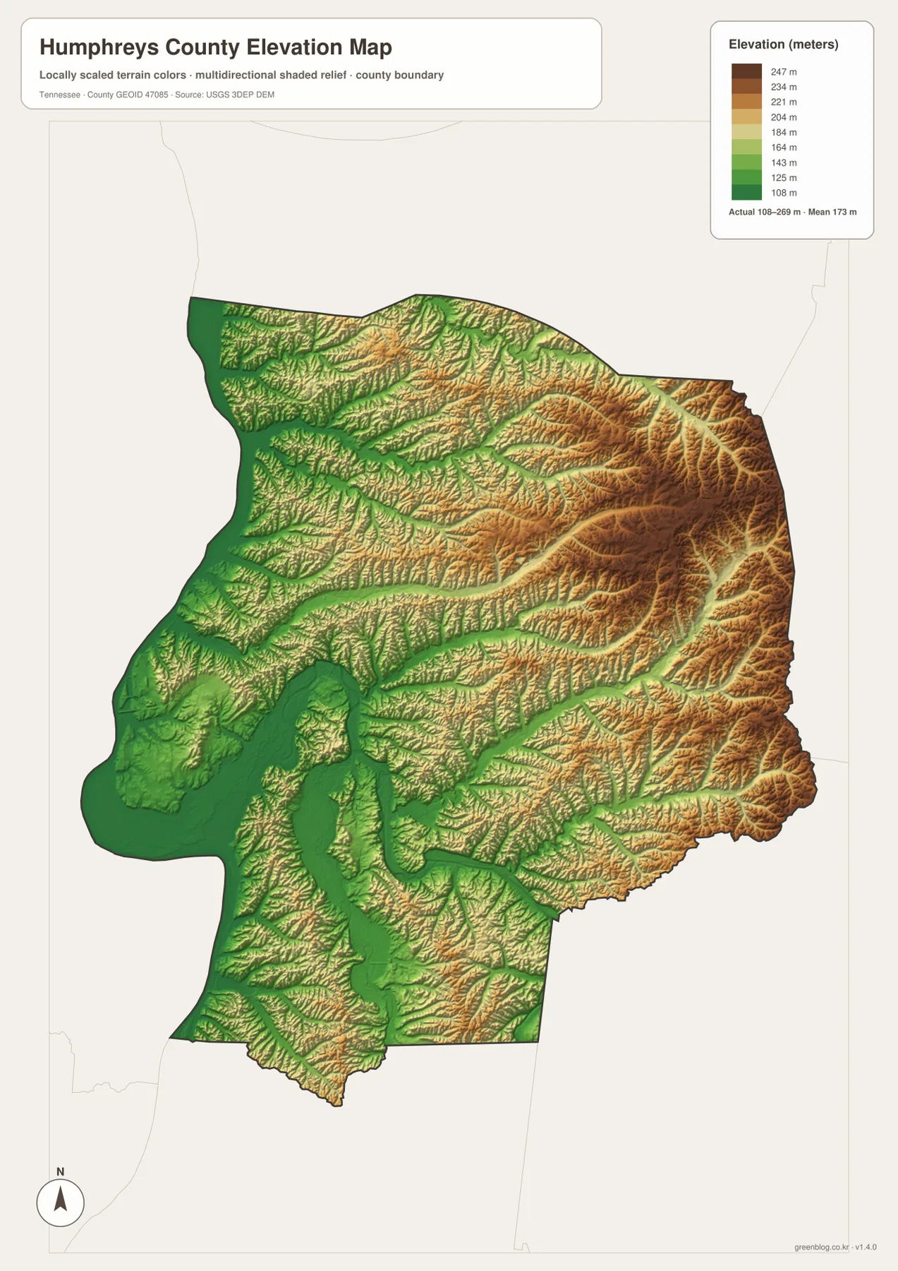
The elevation surface is useful for county-scale comparison rather than a surveyed height at a house or parcel. It clearly shows why the New Johnsonville side is lower, why the McEwen side contains more pronounced uplands, and why the named creeks occupy narrow green corridors between ridges.
Waverly links two very different sides of Humphreys County
The city map provides a simple Waverly–McEwen–New Johnsonville relationship. The county map adds the numbered roads, while the water layer explains why the western side becomes dominated by broad water and low river valleys. The elevation map then shows the opposite pattern across the east, where ridges and creek cuts become more prominent.
A westbound view from Waverly reaches New Johnsonville and lower terrain near the broad water edge. An eastbound view reaches McEwen through more rolling ground. North and south of the main city corridor, Whiteoak Creek, Richland Creek, Duck River, Buffalo River, and Hurricane Creek divide the county into additional smaller valleys.
Use the city map for town positions and straight-line distance, the county map for route numbers and place labels, the water map for the two rivers and named creeks, and the elevation map when the difference between western lowlands and eastern ridges is the main question.
The browser previews are sized for quick reference. The A3 JPG originals provide more room when Route 13, the McEwen road corridor, or smaller water labels such as Richland and Hurricane creeks need to be printed or annotated. Keeping route notes on the base map and drainage notes on the water map also avoids covering the county outline with too many labels.
The ZIP below packages the high-resolution A3 JPG originals used to compare the road network, the three city references, the waterways, and the elevation surface. It is suitable for classroom use, presentations, local orientation, and offline study when the on-page images are too small.
Frequently Asked Questions
What do the Waverly-to-city distance labels mean?
The city map uses straight-line distance rather than driving mileage. Waverly to McEwen is shown at about 8 miles and Waverly to New Johnsonville at about 12 miles, so actual road trips may be longer depending on the route.
How different are the western lowlands and eastern ridges?
The elevation map shows roughly 108–269 meters. The western water edge and Duck–Buffalo river valleys occupy the lowest terrain, while the eastern and northeastern side around the McEwen direction rises into substantially higher rolling ridges.
Sources and reference data
County history and local reference material are available from the Tennessee State Library and Archives Humphreys County fact sheet. Road placement can be compared with the Tennessee Department of Transportation Humphreys County map, and boundary data with U.S. Census Bureau TIGER/Line.
For additional hydrography reference, see USGS National Hydrography. Elevation data can be compared with the USGS 3D Elevation Program. The descriptions here follow the Waverly road network, Duck and Buffalo river valleys, named creeks, and elevation differences visible in the supplied Humphreys County maps.
Map File Information
The archive contains the A3 JPG originals for the Humphreys County road, city, water, and elevation maps shown on this page.
- Included Files: County map, city map, water map, elevation map
- File Type: ZIP containing 4 JPG files
Related Maps
Green Map creates custom-edited map images using open geographic data sources such as geoBoundaries, Natural Earth, OpenStreetMap, and government open data. These maps are edited visual materials, not raw data files, and are provided for education, documents, presentations, and graphic reference.