Download the high-resolution A3 JPG ZIP for this Jackson County Tennessee Map directly from the page; it contains the county, city, water, and elevation maps shown below. Gainesboro is the central reference point, while the Cumberland River–Cordell Hull Reservoir corridor bends repeatedly through the western and central county. North Springs, Dodson Branch, and Mount Union provide useful outer place references, and the terrain rises sharply away from the major river valleys.
Jackson County is better understood as a river-and-hill county than as a simple road grid. Large river bends occupy low green corridors, and a dense network of creeks cuts the surrounding uplands into short ridges. Eastern and southeastern areas contain broad higher terrain, while another high belt appears in the northwest. The road map, water map, and elevation layer all show how strongly those valleys shape movement through the county.
Table of Contents
Gainesboro provides the main settlement reference inside Jackson County
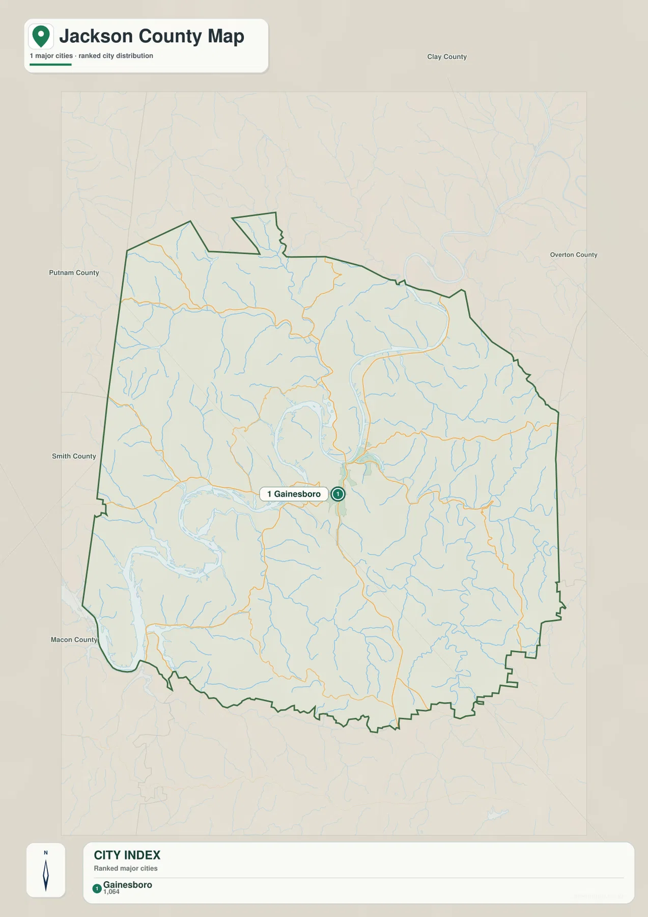
The city layer ranks Gainesboro at 1,064 residents and does not list another major ranked city within the county. That makes the map less about comparing several urban centers and more about locating one clear hub. Gainesboro sits close to the county center and near a major river bend, where several road approaches converge.
Clay County is labeled to the north, Putnam and Smith counties to the west, Macon County to the southwest, and Overton County to the east. These outside labels frame Jackson County’s position in north-central Tennessee. The county outline is irregular, especially where hills and watercourses create long projections and indented boundary sections.
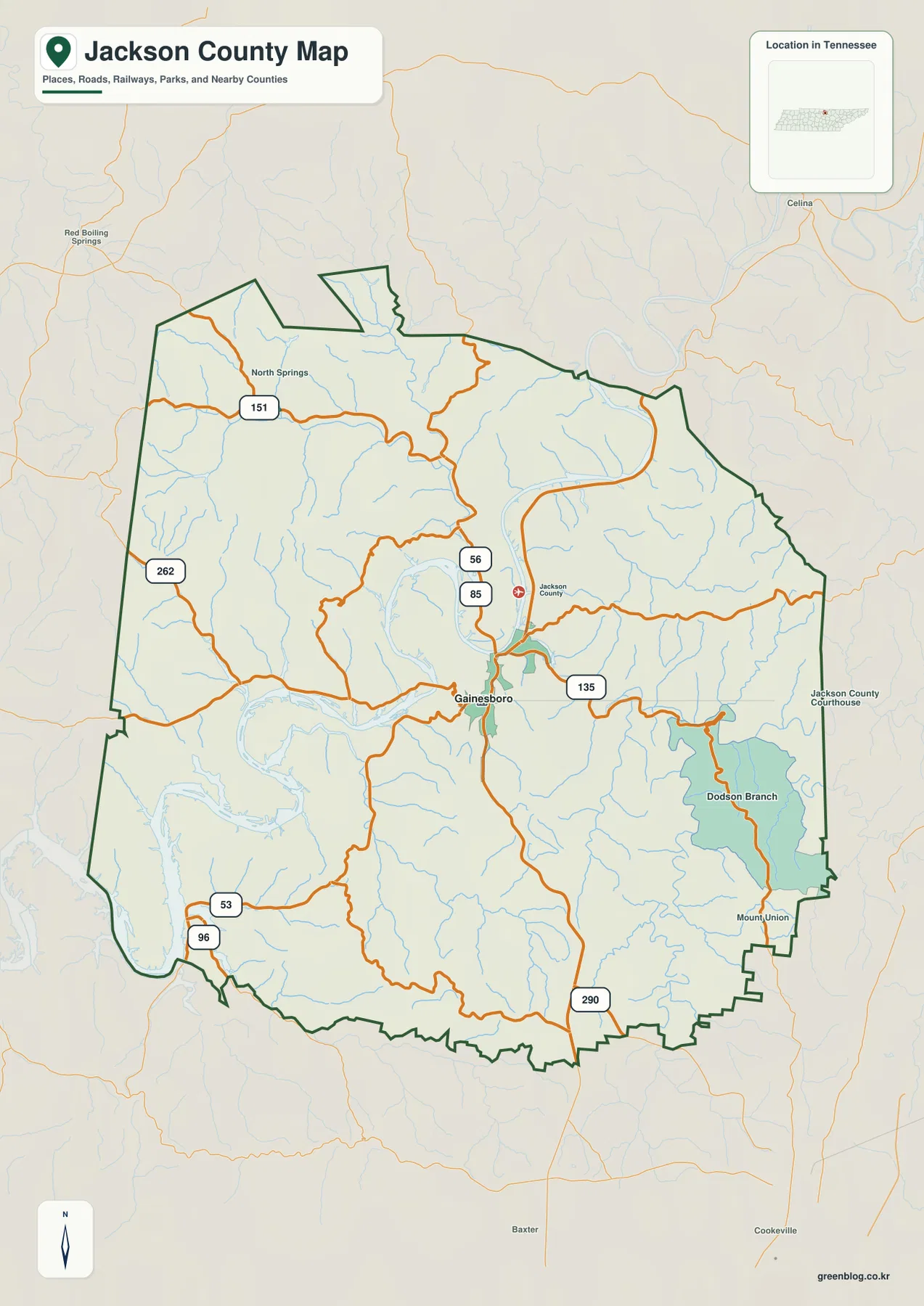
The base map adds smaller names that are not part of the ranked city layer. North Springs appears in the northwest, Dodson Branch in the east, and Mount Union near the southeastern edge. Using the city map for the central hub and the base map for these smaller places keeps the two types of labels easy to distinguish.
Routes 56, 85, and 135 meet the Gainesboro area before spreading into the hills
Routes 56 and 85 are prominent near Gainesboro, and Route 135 extends eastward from the central area. Route 151 provides a strong northwestern reference near North Springs, while Route 262 serves the western side. Once Gainesboro is located, these numbered roads make the county much easier to read than trying to follow every minor line at once.
Routes 53 and 96 appear near the southwestern boundary, and Route 290 crosses the southern to southeastern side. These roads rarely behave like straight lines on a flat map because they pass through short valleys and around river bends. The contrast is particularly clear near the Cumberland River, where water and steep side slopes force several changes in direction.
Dodson Branch is easiest to place in relation to Route 135 and the eastern drainage network, while Mount Union marks the southeastern outer section. North Springs pairs naturally with Route 151 in the northwest. Together, these places give three outer reference points around the Gainesboro hub.
Cumberland River bends connect Cordell Hull Reservoir with a dense creek network
The dominant water feature is the large Cumberland River corridor, with Cordell Hull Reservoir labeled in the southwest. From that reservoir side, the waterway bends repeatedly through the western and central county before continuing toward the northeast. Gainesboro lies close to one of the central bends, so the river is an important orientation feature for both the town and the road network.
Jennings Creek crosses the northwestern interior, and Pine Lick Creek descends from the north toward the major river. Both occupy lower corridors between tightly packed hills. Their green valleys on the elevation map make it clear why the northern terrain appears divided into many short ridges rather than one broad upland surface.
The eastern half contains another set of named channels. Roaring River runs through the east, Morrison Creek occupies a large valley farther south, and Blackburn Fork Creek bends through the southeastern area. Spring Creek, Sugar Creek, and Hopper Creek divide nearby slopes into smaller drainage pockets, while Flynn Creek and Dry Fork add lower passages south of the central river bends.
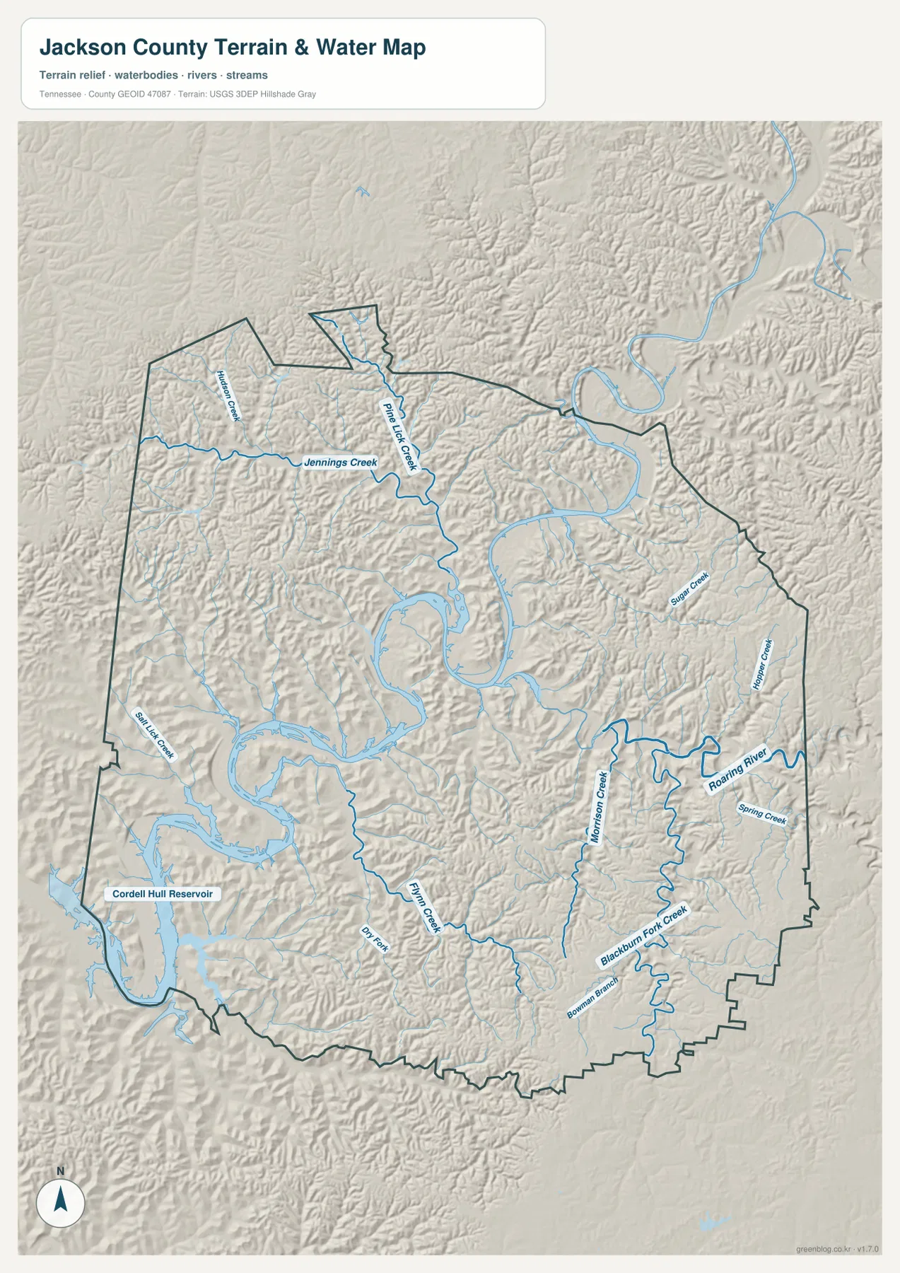
This water image is intended for geographic reference. Reservoir level, boating access, and the condition of individual crossings can change, so current field use requires separate up-to-date information. On this page, the layer is used to show how Gainesboro and the mapped roads fit between the main river bends and the surrounding tributary valleys.
A 152–347 m range separates deep river valleys from high eastern hills
The elevation map shows an actual range of about 152 to 347 meters, with a mean near 238 meters. The lowest dark-green terrain follows the Cumberland River and the larger tributary valleys. Tan and brown higher ground expands across the east and southeast, with another broad high area in the northwest.
Gainesboro itself sits in a transition zone where low river terrain and short ridges are close together. Pine Lick Creek and Jennings Creek cut green passages through the northern hills, while Roaring River and its neighboring streams divide the eastern uplands. This relief helps explain why nearby places may require a much longer road route than a straight line on the page suggests.
The southeast contains some of the strongest brown high ground on the map. Blackburn Fork Creek and smaller tributaries form green corridors within that higher terrain. On the western side, Cordell Hull Reservoir and the Cumberland valley occupy a much broader low zone. The roughly 195-meter countywide range is enough to make the river bottoms and outer hills visibly distinct.
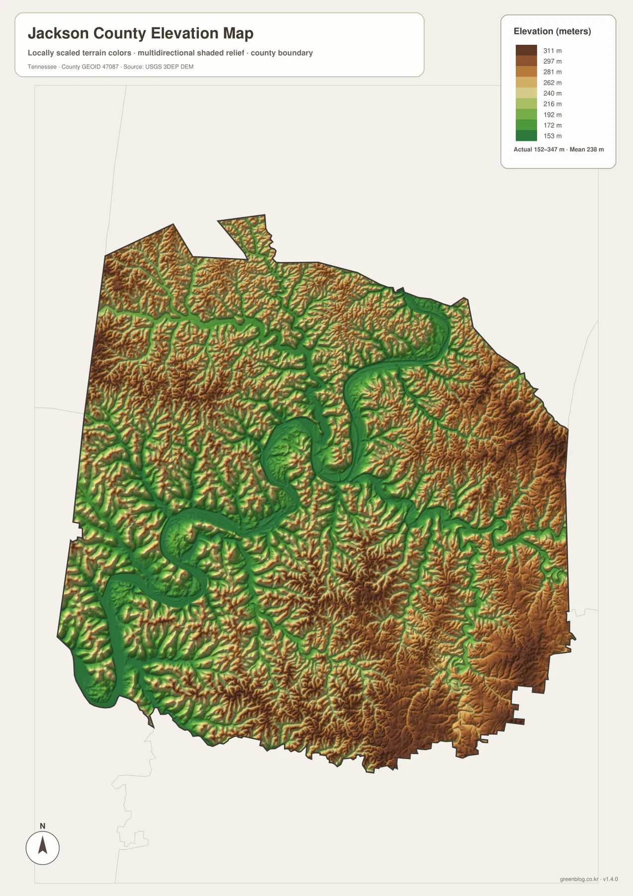
The elevation surface is useful for county-scale comparison rather than a survey-grade height at a specific property. It is especially helpful for matching creek valleys with low green terrain and for seeing how quickly the land rises away from the Cumberland River corridor.
Gainesboro links the main river bend with roads leading into three outer hill areas
The city layer first establishes Gainesboro as the single ranked hub. The county map then adds North Springs, Dodson Branch, Mount Union, and the numbered roads. The water layer explains how the Cumberland River and tributaries divide those places, and the elevation image shows the hills that rise between each valley.
West of Gainesboro, the Cumberland River and Cordell Hull Reservoir lowlands become the main visual reference. East and southeast, Roaring River, Blackburn Fork Creek, and higher ridges are more important. In the northwest, Jennings Creek and Route 151 provide an easy way to locate the North Springs side.
Use the city map for Gainesboro’s position, the county map for roads and smaller place labels, the water map for river bends and tributaries, and the elevation map when the contrast between low valleys and high outer hills is the main question.
A3 JPG originals for closer study and printing
The WebP previews are sized for quick browser viewing. The A3 JPG originals are more useful when Routes 56, 85, and 135 or smaller creek labels such as Jennings and Morrison need to be enlarged or annotated. Keeping route notes on the county map and drainage notes on the water map also prevents labels from becoming crowded.
The elevation JPG is particularly useful in color because the Cumberland valley remains dark green while eastern and southeastern ridges shift into tan and brown. The city layer is the simplest choice when a presentation only needs to show where Gainesboro sits inside the county.
The ZIP below packages the high-resolution A3 JPG originals for the county, city, water, and elevation maps used on this page. They are suitable for classroom comparison, presentations, local orientation, and offline reference when the on-page images are too small.
Frequently Asked Questions
Why is Gainesboro the only ranked city on the city map?
The supplied city layer ranks Gainesboro at 1,064 residents. Smaller place labels such as North Springs, Dodson Branch, and Mount Union appear on the base county map instead, so the two layers are designed to answer different levels of location detail.
How large is the elevation difference between the Cumberland valley and the outer hills?
The elevation map shows roughly 152–347 meters. The Cumberland River and major tributary valleys occupy the lowest green terrain, while eastern, southeastern, and northwestern hills rise substantially higher, producing about 195 meters of countywide relief.
Sources and reference data
County history and local reference material are available from the Tennessee State Library and Archives Jackson County fact sheet. Road placement can be compared with the Tennessee Department of Transportation Jackson County map, and boundary data with U.S. Census Bureau TIGER/Line.
For additional hydrography reference, see USGS National Hydrography. Elevation data can be compared with the USGS 3D Elevation Program. The descriptions here follow Gainesboro, the Cumberland River–Cordell Hull Reservoir corridor, mapped roads, tributaries, and elevation differences visible in the supplied Jackson County maps.
Map File Information
The archive contains the A3 JPG originals for the Jackson County road, city, water, and elevation maps shown on this page.
- Included Files: County map, city map, water map, elevation map
- File Type: ZIP containing 4 JPG files
Related Maps
Green Map creates custom-edited map images using open geographic data sources such as geoBoundaries, Natural Earth, OpenStreetMap, and government open data. These maps are edited visual materials, not raw data files, and are provided for education, documents, presentations, and graphic reference.