Nashville is the quickest way to orient yourself on a Davidson County map, but the county becomes much clearer when the river, reservoirs, smaller cities, and surrounding boundaries are viewed together. This page includes separate views for the county, major cities, water features, and elevation. A ZIP containing four high-resolution A3 JPG maps is available in the map file section below.
The Nashville–Davidson metropolitan area occupies the central part of the county, while Belle Meade, Forest Hills, Oak Hill, and Berry Hill form a compact group to the south. Goodlettsville and Ridgetop sit near the northern edge. The Cumberland River makes broad bends across the county, and Percy Priest Reservoir dominates the eastern water map, creating a geography that is much more varied than a simple urban outline suggests.
Table of Contents
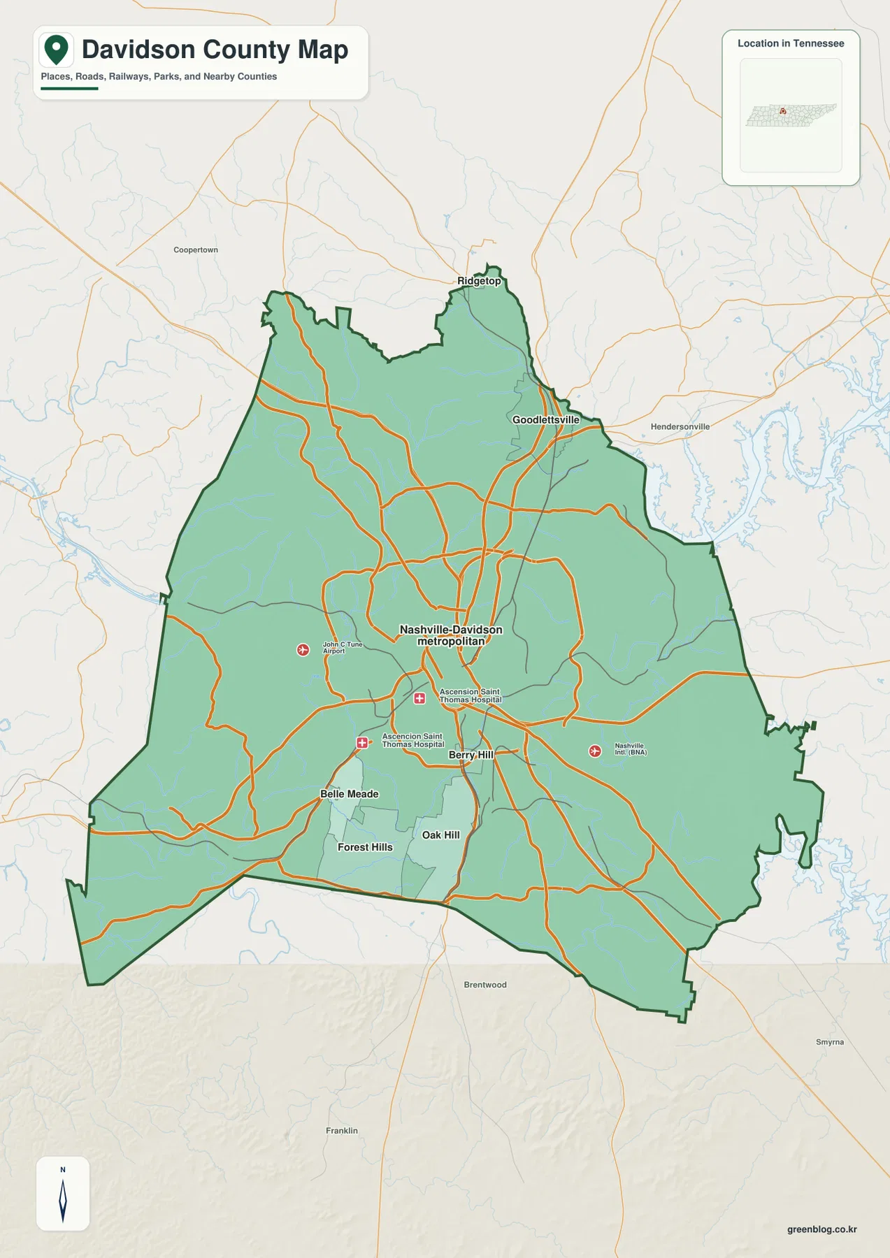
Nashville at the center of the county road network
The general county map places Nashville near the center of a dense network of major roads. The package identifies I-24, I-40, I-65, I-440, US 31, and US 31A as important county-scale routes. They approach Nashville from several directions, then continue toward the outer parts of Davidson County and neighboring counties. Looking at the boundary first makes it easier to see which roads remain within the county and which ones quickly cross into the wider Middle Tennessee region.
The map also shows how different the southern and northern edges are. Belle Meade and Forest Hills lie southwest of central Nashville, Oak Hill sits farther east, and Berry Hill is much closer to the central urban area. Goodlettsville appears near the northeastern boundary, while Ridgetop reaches the northern edge. These locations are useful anchors because they prevent the large Nashville label from obscuring the smaller municipalities that occupy distinct parts of the county.
Nashville International Airport is marked southeast of the central city, and John C. Tune Airport appears to the west. These are secondary reference points rather than the focus of the page, but they help explain why major roads and developed areas extend in more than one direction. The result is a county whose transportation pattern is concentrated around Nashville without being limited to a single downtown corridor.
A cluster of small cities south of Nashville and communities near the northern edge
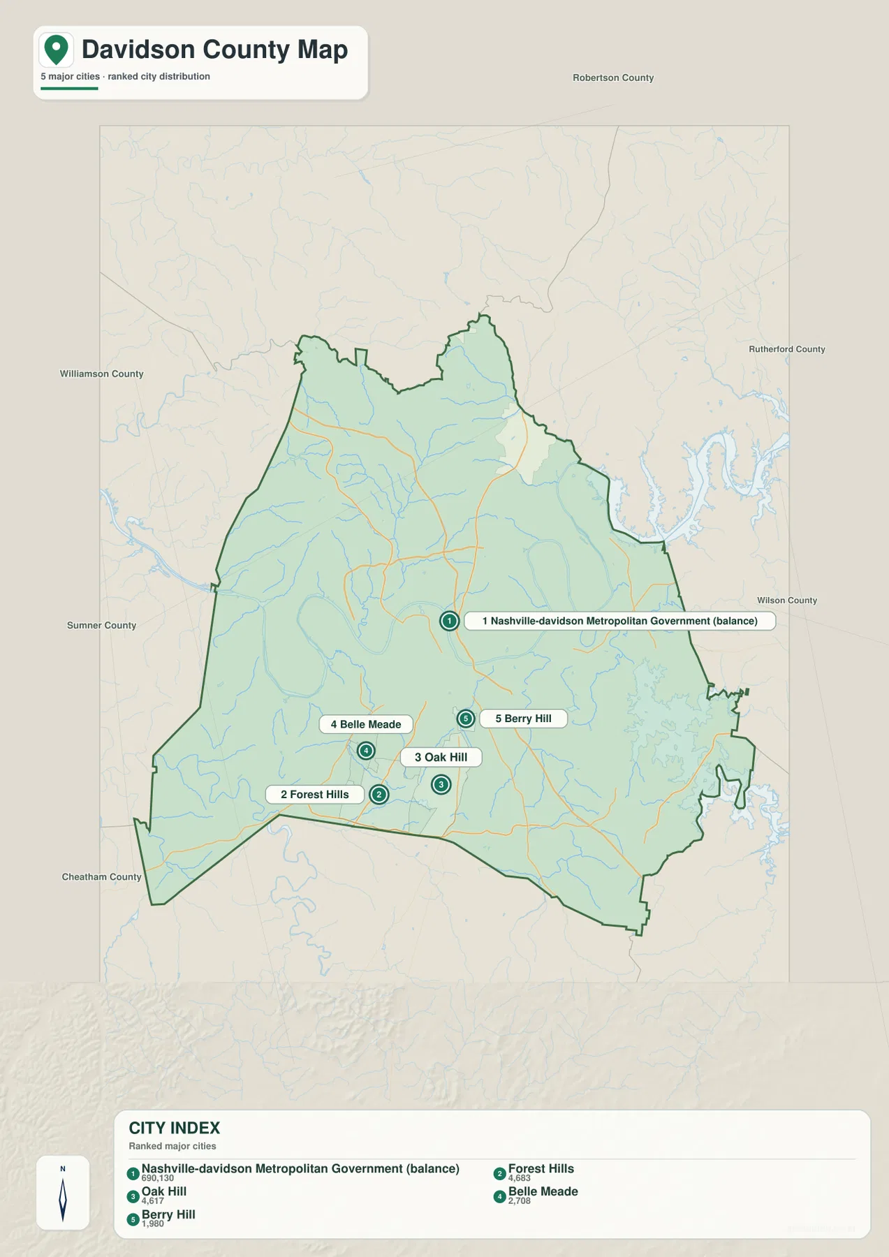
The city view ranks Nashville–Davidson Metropolitan Government first and then highlights Forest Hills, Oak Hill, Belle Meade, and Berry Hill. The more useful detail is their placement. Forest Hills and Belle Meade sit in the southwest side of the urban area, Oak Hill lies farther east, and Berry Hill is tucked close to central Nashville. Seeing them together makes the southern half of the county easier to read than a long list of municipality names would.
The county boundary adds another layer of context. Robertson County is north, Sumner County lies to the northeast and northwest edges shown on the map, Wilson County is east, Rutherford County is southeast, Williamson County is south and southwest, and Cheatham County is west. The city map therefore works well for checking whether a place near the edge is actually inside Davidson County or simply part of the same metropolitan area across a county line.
This distinction matters in a large urban county. Continuous streets and development can make administrative boundaries difficult to notice on the ground, especially around the outer parts of Nashville. The map keeps the county outline visible so the smaller municipal labels can be read in the correct geographic context.
Cumberland River bends, Percy Priest Reservoir, and smaller lakes
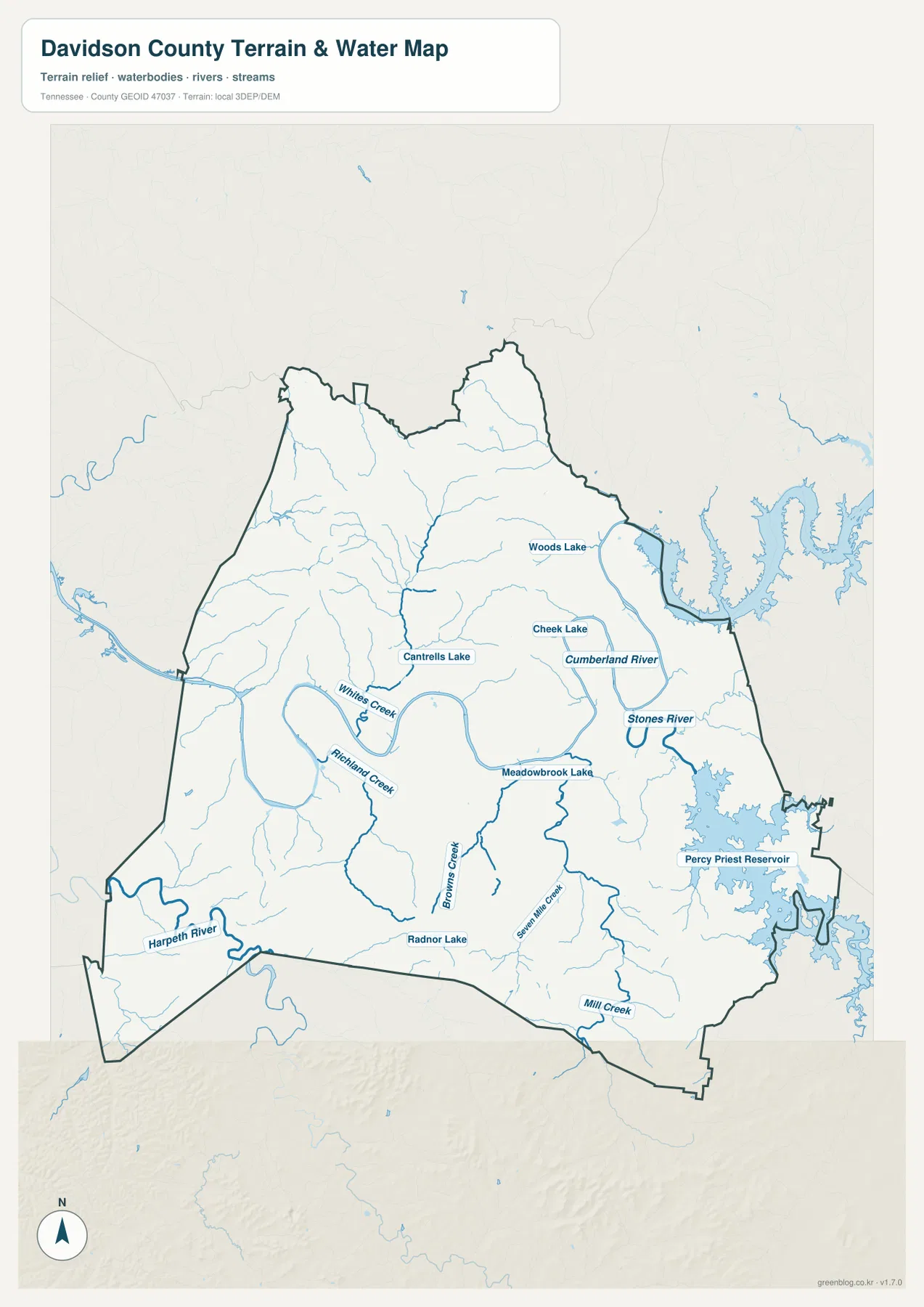
The water map is dominated by the Cumberland River. It enters from the western side, loops through the central part of the county, and continues eastward. Those bends are important because they divide parts of the urban area and create repeated river crossings. Even without road labels on the water view, the relationship between the river and Nashville is immediately visible.
On the eastern side, Percy Priest Reservoir forms the largest mapped body of water within the county view. Stones River is labeled nearby, connecting the reservoir area to the broader drainage network. The northeastern edge also approaches the Old Hickory water system outside the county boundary. This makes eastern Davidson County visually different from the western side, where the Cumberland River and smaller tributaries are more prominent than a single broad reservoir.
Several smaller lakes add useful local reference points. Woods Lake and Cheek Lake appear north and east of the central area, Cantrells Lake and Meadowbrook Lake sit closer to the middle, and Radnor Lake is farther south. Whites Creek and Richland Creek feed the western and central drainage pattern, while Browns Creek, Seven Mile Creek, and Mill Creek mark valleys in the southern half of the county. Harpeth River reaches the southwestern edge, giving that corner a water feature that is separate from the Cumberland system shown across most of the county.
This map is best used to compare locations of rivers, reservoirs, lakes, and streams. It does not provide live water levels, flood forecasts, boating channels, or legal access information. For those purposes, current agency data should be checked separately.
From river bottoms to higher ridges: about 24 to 349 meters
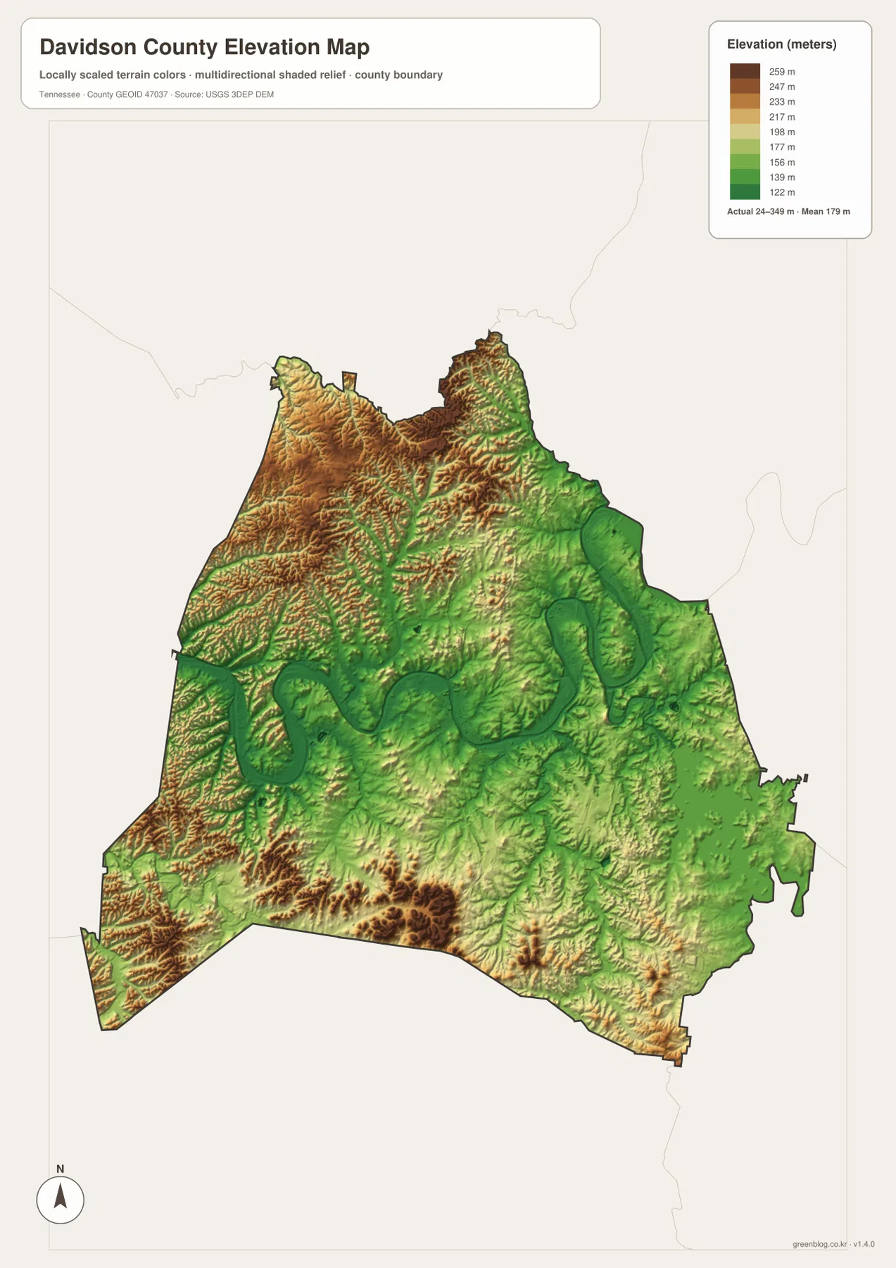
The elevation map reports an actual range of roughly 24 to 349 meters, with a mean near 179 meters. The lowest areas form long green corridors that follow the Cumberland River and several tributaries. Higher ground appears as a web of ridges between those valleys, so the county does not read as a uniformly flat metropolitan landscape.
Higher terrain is especially noticeable in the northwestern and northern sections, with another group of elevated ridges in the southwest. By contrast, the central and eastern river corridors contain broad stretches of lower ground. The contrast is easiest to understand when the elevation map is compared with the water map: many of the green low areas line up with the Cumberland River and its tributary valleys.
The shaded relief is intended for county-scale comparison. It is useful for recognizing where ridges and valleys are concentrated, but it should not be treated as a parcel survey, engineering surface, or substitute for site-specific elevation data. The main value here is seeing how strongly local relief persists inside a county dominated by a major city.
Why the road map makes more sense beside the river map
Major roads radiate from Nashville, but their geography is shaped by water and relief. The Cumberland River forces repeated crossings around the central city, while smaller streams occupy valleys that cut through the surrounding hills. I-24, I-40, and I-65 provide the largest regional approaches, yet the water and elevation maps explain why the network does not look like a simple grid.
The eastern side offers a particularly clear example. Percy Priest Reservoir occupies a large area close to the county boundary, while Stones River and smaller streams approach it from different directions. In the south, Radnor Lake and several creeks sit among rolling terrain near Forest Hills and Oak Hill. North of Nashville, the river and its tributaries separate some of the routes leading toward Goodlettsville and the northern county line.
Using the maps together is therefore more informative than treating each layer as a separate product. The county map establishes the roads and place names, the city view simplifies the municipality pattern, the water map shows where major crossings and reservoir edges occur, and the elevation map reveals the ridges between those waterways.
Population and area in a large urban county
The source material in this package lists a 2020 Census population of 715,884 and a July 2025 estimate of 745,904 for Davidson County. It also lists about 503.5 square miles of land and 21.8 square miles of water. Those figures are helpful for understanding county scale, but they do not describe how people are distributed block by block across Nashville, the smaller municipalities, river corridors, and outer ridges.
The city map helps put those totals in context. Nashville–Davidson Metropolitan Government is by far the largest labeled urban unit, while Forest Hills, Oak Hill, Belle Meade, and Berry Hill occupy much smaller areas to the south. A countywide average therefore should not be read as if development or population were evenly spread from the central city to the water bodies and outer edges.
Choosing the most useful Davidson County map
Use the general county map when you need Nashville, the county boundary, major roads, and surrounding municipalities on one page. The city map is better when the main question is how Forest Hills, Oak Hill, Belle Meade, and Berry Hill relate to central Nashville. For rivers, reservoirs, and lakes, the water map gives the clearest view of the Cumberland River and Percy Priest Reservoir, while the elevation map is the best choice for comparing low river corridors with higher ridges.
The downloadable files are useful for printing, classroom work, presentations, location notes, or personal reference. The ZIP below contains the same four map types discussed on this page as high-resolution A3 JPG files.
Frequently Asked Questions
Where does the Cumberland River run through Davidson County?
The Cumberland River enters from the west, makes broad bends through the central part of the county around Nashville, and continues toward the east. The water map makes those curves easy to compare with Percy Priest Reservoir and Stones River on the eastern side.
Which smaller cities are closest to central Nashville on the city map?
Berry Hill is shown very close to central Nashville, while Belle Meade, Forest Hills, and Oak Hill form a group farther south. The map is designed to compare their relative positions inside Davidson County rather than provide street-level municipal boundaries.
How much elevation change is shown across Davidson County?
The elevation map reports an actual range of about 24 to 349 meters, with a mean near 179 meters. Lower areas follow the Cumberland River and other stream valleys, while higher ridges are more visible in the northwestern, northern, and southwestern parts of the county.
Map File Information
This ZIP contains high-resolution A3 JPG versions of the Davidson County county map, city map, water map, and elevation map.
- Included Files: 4 map JPGs
- File Type: JPG and ZIP
Related Maps
Sources
County boundaries and basic geography can be checked with the U.S. Census Bureau TIGER/Line files. Population and area figures are available from U.S. Census Bureau QuickFacts and the Census Gazetteer Files.
For local historical context, the package points to the Tennessee State Library and Archives Davidson County fact sheet. The terrain and water layers can also be understood alongside the USGS 3D Elevation Program and USGS National Hydrography.
Green Map creates custom-edited map images using open geographic data sources such as geoBoundaries, Natural Earth, OpenStreetMap, and government open data. These maps are edited visual materials, not raw data files, and are provided for education, documents, presentations, and graphic reference.