Winnebago County occupies Iowa’s northern tier directly below the Minnesota state line, and its towns are spread across a broad rural grid rather than gathered around one central urban area. Forest City, the county seat, sits close to the southern boundary. Lake Mills is farther east, Buffalo Center anchors the western side, while Rake and Scarville lie close to the northern edge. Thompson and Leland fill positions between those outer towns. The four maps on this page can be downloaded as high-resolution JPG files in one ZIP for closer viewing or printing. High-resolution map files are available for download in the section below.
The county looks orderly on the road layer because straight local roads form a dense grid, but the water and elevation maps reveal a more varied landscape underneath. U.S. 69 provides a useful north–south reference through the eastern half, and Iowa 9 helps orient the southern part of the county. Beyond the roads, the Winnebago River and Lime Creek shape the east, while Buffalo Creek and the Middle Branch Blue Earth River belong to a different western drainage pattern. Elevation ranges from roughly 343 to 426 meters, with lower ground widespread in the west and more broken, higher terrain across much of the center and east.
The city index used for the supplied map places Forest City first and Lake Mills second, followed by Buffalo Center, Thompson, Leland, and Rake. Scarville appears on the general county map and is also one of the seven cities listed by the county government, even though it is not included in the six-place city ranking shown here. Reading those settlements together with streams and relief is more useful than treating each map as a separate picture. The sections below follow real map features and explain what each layer adds, while keeping in mind that these are reference maps rather than legal survey, flood, or navigation products.
Table of Contents
Forest City, Lake Mills, and Buffalo Center spread across the Minnesota-border county
The general county map is the best place to understand how widely separated the communities are. Forest City occupies the southern edge and works as the clearest anchor for orientation. Lake Mills lies well to the east, Buffalo Center sits near the western side, and Rake and Scarville occupy opposite corners of the north. Thompson is near the middle of the county, while Leland lies southeast of center. Because the towns do not form one continuous corridor, a map that shows the whole county is more informative than a single city enlargement when the goal is to understand regional position.
Straight section-line roads dominate the rural areas and create a near-rectangular network. U.S. 69 is the most recognizable numbered route on the eastern half of the map, linking the Forest City and Lake Mills area and providing a strong north–south reference. Iowa 9 crosses the southern portion and gives another reliable orientation line near Forest City. Numerous county and local roads fill the spaces between those routes, so the map looks highly connected even where settlement is sparse. The pattern is useful for orientation, but it should not be read as a live report of road construction, winter conditions, or closures.
The surrounding geography also matters. Winnebago County meets Minnesota along its northern edge, while Kossuth and Hancock counties lie to the west and southwest, and Worth and Cerro Gordo counties lie to the east and southeast. The city map labels these neighboring counties outside the border, making it easier to place Winnebago County within northern Iowa. Rake and Scarville are especially useful reference points because their northern positions make the state boundary immediately understandable, while Forest City provides the southern counterpoint.
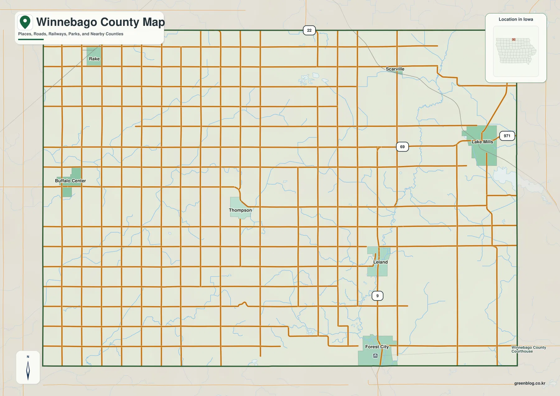
Use this general map for broad county orientation rather than parcel decisions. Small road bends, property lines, legal rights-of-way, and exact municipal limits may be generalized at this scale. Iowa DOT and local government sources should be checked when a current route, construction condition, or official boundary matters. For basic questions such as whether Lake Mills lies east of Thompson, how far Rake is from Forest City on the county grid, or where Buffalo Center sits relative to U.S. 69, the general map provides the fastest overview.
A two-center settlement pattern led by Forest City and Lake Mills
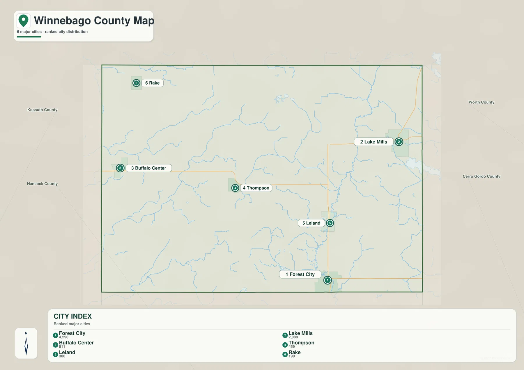
The city map strips away much of the road detail and ranks six major communities. Its index lists Forest City at 4,290, Lake Mills at 2,068, Buffalo Center at 911, Thompson at 459, Leland at 306, and Rake at 190. These are the values used for the map graphic and should be treated as comparative reference numbers rather than a promise that they match the latest population estimate. The main message is spatial and proportional: Forest City is the largest center, Lake Mills is a clear second, and the remaining towns are much smaller and more widely dispersed.
Forest City’s position is unusual for a county seat because it is close to the southern boundary rather than the geographic center. Lake Mills provides a second sizeable focus in the east. Buffalo Center is separated from both by a broad western agricultural area, while Thompson sits closer to the middle and serves as an easy reference when comparing east and west. Leland is southeast of center, and Rake is near the northwest corner. This arrangement explains why the county’s road network cannot be summarized as a simple set of spokes from one city.
Scarville deserves a separate note. It appears on the general county map near the northeastern side, but it is absent from the six-place ranked city index. The official Winnebago County communities page lists seven cities—Buffalo Center, Forest City, Lake Mills, Leland, Rake, Scarville, and Thompson. The city index on this page therefore works best as a ranked display of selected major communities, not as a complete municipal inventory. For current municipal services, officials, or demographic figures, the appropriate city and county sources should be consulted.
The distribution becomes more meaningful when it is connected to physical geography. Lake Mills and Leland are close to the eastern Winnebago River and Lime Creek system, while Buffalo Center and Rake sit in the western part of the county near different streams and drainage directions. Forest City is near the southern Winnebago River corridor. The towns are not simply dots on a flat agricultural surface; they occupy different parts of a landscape divided by several drainage systems and modest but visible changes in elevation.
The Winnebago River and Lime Creek organize the eastern half
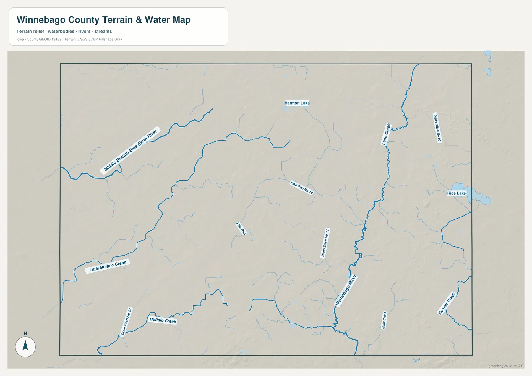
The most prominent water feature in the eastern half is the Winnebago River. It runs generally north to south through the interior east side, creating a continuous reference line between the northern drainage network and the Forest City area. Lime Creek approaches from the northeast, and numerous smaller tributaries feed the system. On the road map this part of the county appears dominated by straight lines, but the water layer replaces that rigid geometry with branching channels that follow the lower terrain.
Rice Lake appears near the eastern edge not far from the Lake Mills side of the county, while Harmon Lake is shown farther north and closer to the county interior. Neither lake dominates the county at this scale, yet both are useful landmarks for connecting place names to water features. The map also labels drainage channels such as Drain Ditch No. 52 and Lime Ditch No. 11. Their straighter appearance distinguishes them from many of the naturally winding streams and is a reminder that northern Iowa’s drainage network includes both natural channels and managed agricultural drainage features.
Those distinctions matter when using the map. A blue line is not automatically a large natural river, and the static map does not define legal drainage-district boundaries or maintenance responsibility. The purpose here is to show where named water features lie relative to towns and roads. The Winnebago River is the dominant eastern reference, Lime Creek forms an important northeastern branch, and small ditches and tributaries connect the surrounding agricultural land to those larger channels.
Forest City and Leland make good anchors for following the eastern drainage system. Both lie near the lower Winnebago River corridor, although the map does not imply that every nearby parcel shares the same flood exposure. Lake Mills is associated with a different mix of nearby channels, including Lime Creek and Rice Lake to the east. Current river stage, flood warnings, water access, and drainage operations can change over time, so USGS and local official information should be used when conditions rather than geography are the question.
Blue Earth and Buffalo Creek drainage gives the west a different pattern
The western side of Winnebago County does not simply feed into the same river network shown in the east. The Middle Branch Blue Earth River bends across the northwest, and Little Buffalo Creek and Buffalo Creek appear farther south around the Buffalo Center side. These waterways create a second geographic story that is easy to miss on the general road map. Instead of one countywide trunk stream, the supplied water layer shows major channels heading through different parts of the county and organizing the landscape in separate directions.
Buffalo Center and Rake are useful places for reading this western pattern. Buffalo Center sits near small tributaries and the Buffalo Creek system, while Rake lies closer to the northwestern drainage that connects with the Middle Branch Blue Earth River. Rural roads cross these channels in straight segments, but the underlying terrain drops gently into stream valleys. Bridges, culverts, and drainage structures therefore become part of the real landscape even where the road grid looks uniform on the map.
For classroom or regional comparison, it can be helpful to trace the eastern Winnebago River and Lime Creek network in one pass, then return to the west and follow the Blue Earth and Buffalo Creek features separately. This makes the drainage contrast easy to explain without pretending that the map provides exact watershed boundaries. Detailed basin delineation, drainage engineering, and legal district information require authoritative hydrologic and local records. The map is best at answering the simpler question of where the named channels are and how they relate to communities and relief.
A 343–426 meter range separates lower western ground from broken central and eastern uplands
The elevation map reports an actual range of about 343 to 426 meters and a mean near 377 meters. The color pattern is immediately different from the road grid. Broad green areas dominate much of the west, indicating lower ground, while tan and brown uplands become more common toward the center and east. The northeastern and south-central portions contain several higher blocks separated by narrow lower corridors. The county therefore does not rise in one smooth direction; higher ridges and lower drainage routes alternate across the landscape.
The Winnebago River stands out as a lower green corridor through the eastern interior. Small tributaries cut side valleys into the surrounding higher ground, and Lime Creek creates another low branch in the northeast. Around Leland and north of Forest City, these green channels make the water network visible even without reading every stream label. The same effect appears in the west along Buffalo Creek and the Middle Branch Blue Earth River, although the surrounding western surface is already lower overall.
Thompson lies near a transition between the broad western lowlands and more broken terrain to the east. The southern part of the county also shows a patchwork of higher brown ground and lower stream corridors rather than one level plain. That pattern helps explain why roads that look perfectly straight in plan view may still cross subtle rises, drainage swales, and creek valleys in the field. The approximately 83-meter countywide elevation spread is modest compared with mountain terrain, but it is enough to produce meaningful local relief.
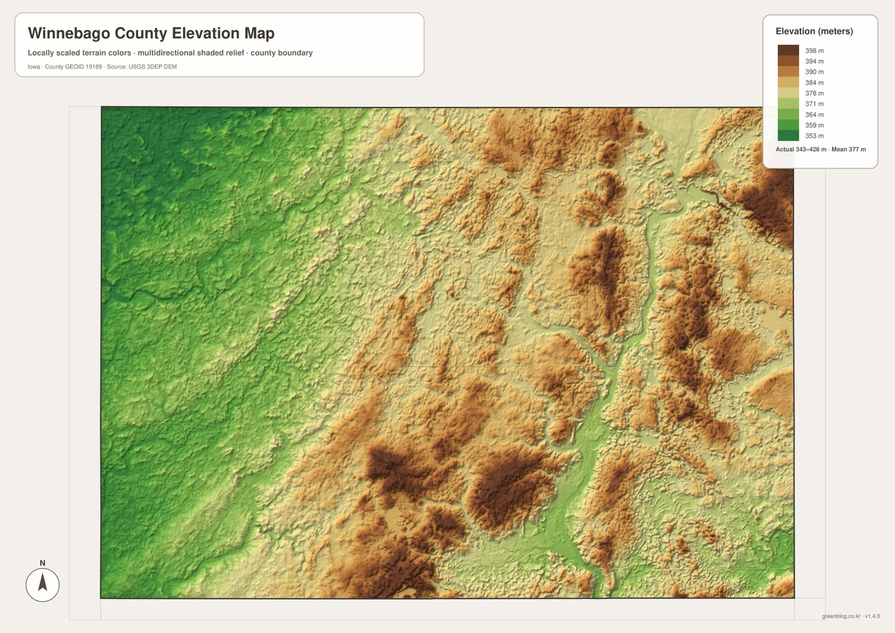
This elevation layer is designed for county-scale comparison, not engineering. It should not be used to determine a building pad elevation, legal parcel height, drainage grade, road-design slope, or other survey-level measurement. Those tasks require current site-specific surveying and authoritative elevation data. The useful reading here is relative: the west is generally lower, the Winnebago River forms a continuous low corridor in the east, and higher terrain is more broken across the central and eastern portions of the county.
Following one place through all four maps makes the layers easier to use
Forest City is the easiest place to use as a cross-map anchor. Find it first on the general map near the southern boundary, then note U.S. 69 and Iowa 9. On the city map, it is the largest ranked community. On the water layer, the nearby Winnebago River and small tributaries add a drainage context that the road map cannot show. Finally, the elevation map reveals lower river corridors against adjacent higher ground. The location stays the same while each file contributes a different kind of information.
Lake Mills provides an eastern comparison. It is the second-largest community on the city index and lies close to the U.S. 69 corridor. The water map adds Lime Creek, the Winnebago River system, and Rice Lake on the east side. The elevation layer shows that the surrounding area is not a uniform flat surface; higher patches and stream-cut lows repeat across the eastern terrain. Buffalo Center produces the opposite comparison, pairing a western community with lower average ground and the Buffalo Creek side of the drainage network.
Rake and Scarville are useful when the goal is to understand the Minnesota-border orientation. They occupy opposite sides of the northern portion and make the county’s east–west width easy to visualize. Small streams and rural roads lie between them, but their labels can be difficult to read on a reduced web preview. The original JPG files are more useful for zooming, printing, or examining smaller names. They preserve the same countywide view while providing substantially more pixels than the embedded previews.
Choose the file according to the question. The general county map is best for roads, town positions, and boundaries. The ranked city map simplifies settlement comparison. The water map is the clearest choice for the Winnebago River, Lime Creek, Blue Earth branch, Buffalo Creek, lakes, and ditches. The elevation map is the fastest way to compare lower western ground with higher and more dissected central-eastern terrain. The four files are complementary views rather than competing versions of the same information.
The downloadable package contains the same Winnebago County general, city, water, and elevation maps shown on this page as high-resolution JPG files. Each original image is 3638 × 2572 pixels, which is more practical than the web preview for close inspection and printing. They are useful for personal reference, education, route orientation, and geographic comparison. For legal boundaries, parcel decisions, flood determinations, construction, or current travel conditions, use the responsible government agency’s current records instead of relying on these reference images.
Frequently Asked Questions
Which map should I use to compare Forest City and Lake Mills?
Start with the general county map because it shows both communities with the major roads and the full county boundary. Forest City is near the southern edge, while Lake Mills is in the east, and U.S. 69 provides a useful north–south reference. The city map then adds their relative size within the supplied ranking. For exact driving distance, live construction, and travel time, use a current navigation service and Iowa DOT information.
Do the eastern and western streams belong to one simple drainage pattern?
No. The supplied map shows a prominent Winnebago River and Lime Creek system in the east, while the western side includes the Middle Branch Blue Earth River and Buffalo Creek features. That contrast is one of the most useful county-specific details on the water map. Exact watershed limits or drainage-district boundaries should be obtained from USGS and appropriate local records rather than inferred from this reference map.
Can the 343–426 meter elevation map be used for surveying or construction?
No. It is a generalized county-scale elevation surface intended to compare relative terrain such as lower western ground, the Winnebago River valley, and higher central-eastern uplands. It does not provide surveyed parcel elevations, legal boundaries, construction grades, or engineering measurements. Site planning and design require current survey and official elevation data.
Map File Information
The ZIP contains high-resolution JPG files matching the Winnebago County general, city, water, and elevation maps shown on this page.
- Included Files: Use only the versions confirmed in the article and supplied images
- File Type: Use the confirmed download contents
- Intended Use: Printing, education, presentations, and map-based projects
Related Maps
Sources and references
These official sources provide additional information about Winnebago County government, its communities, transportation mapping, boundaries, hydrography, and elevation data.
- Winnebago County, Iowa official website – county government and local information
- Winnebago County Communities – official listing of Forest City, Lake Mills, Buffalo Center, and the county’s other cities
- Iowa DOT Winnebago County Maps – county and city transportation map resources
- U.S. Census Bureau TIGER/Line – administrative boundaries and transportation geography
- USGS National Hydrography – rivers, streams, lakes, and water features
- USGS 3D Elevation Program – elevation data
Green Map creates custom-edited map images using open geographic data sources such as geoBoundaries, Natural Earth, OpenStreetMap, and government open data.
These maps are edited visual materials, not raw data files, and are provided for education, documents, presentations, and graphic reference.