Real County Texas map|Frio Canyon roads, Nueces headwaters, and Hill Country towns

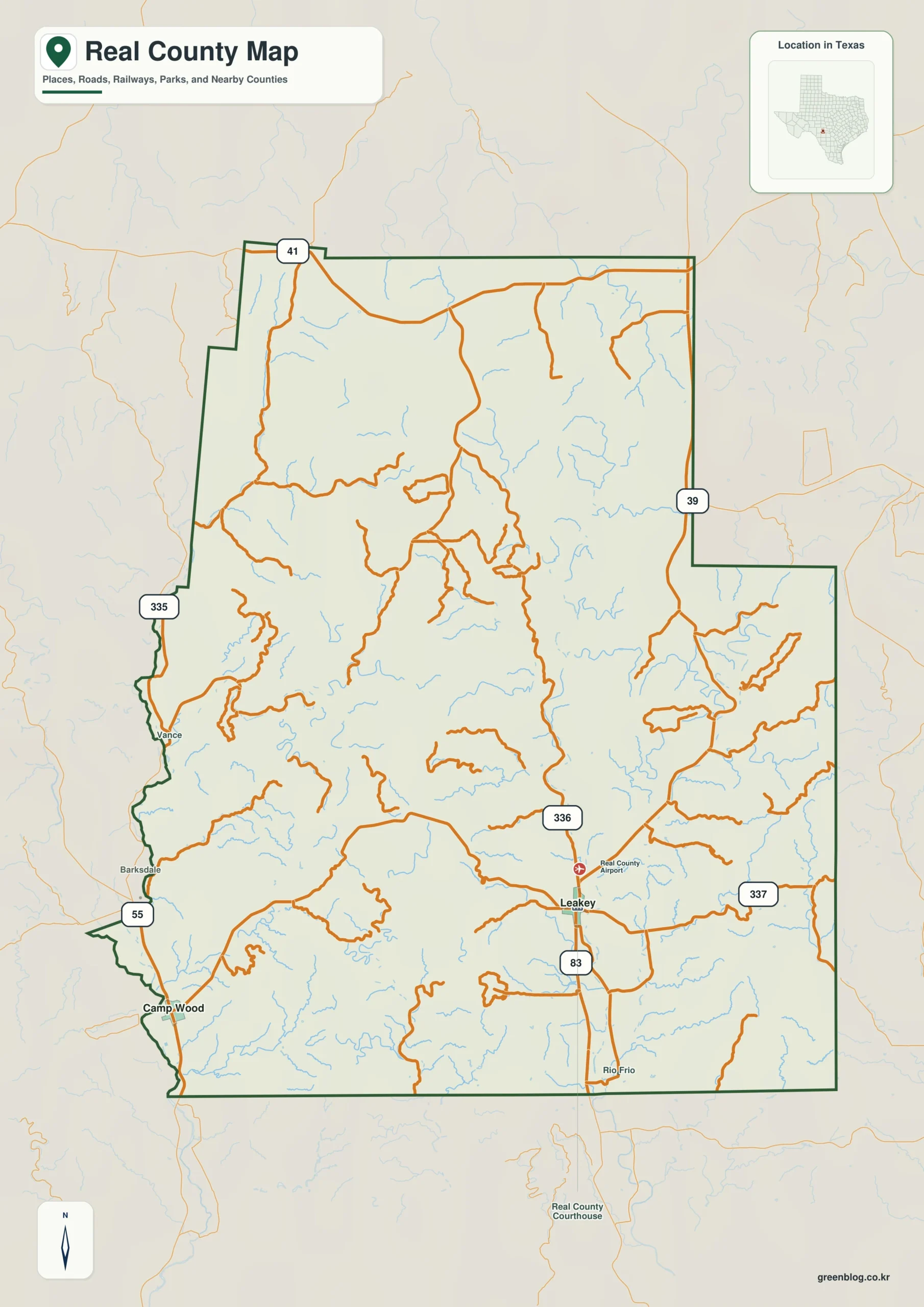
Few Texas counties are organized so clearly around two separate canyon systems. The Real County Texas map shows Leakey in the Frio Canyon, Camp Wood and Barksdale along the upper Nueces, and Rio Frio near the southern county line. Only 2,772 residents were estimated in 2024, yet summer river traffic can make these small communities feel far busier than the year-round population suggests.

The county covers 699.16 square miles of land on the southern edge of the Edwards Plateau. Springs, limestone ridges, narrow valleys, and steep divides channel settlement into a small number of corridors. For drivers, river geography matters as much as county boundaries because the most direct-looking route may still follow a winding farm road through the hills.

  • Continent: North America
  • Country: United States
  • State: Texas
  • County: Real County
  • Location in State: Southwest Texas, southern Edwards Plateau and Hill Country
  • Adjacent Counties: Edwards County, Kerr County, Bandera County, Uvalde County
  • Major Places: Leakey, Camp Wood, Barksdale, Rio Frio
  • Geographic Features: Frio River, Nueces River, limestone canyons, Edwards Plateau

The Three Twisted Sisters define the driving geography

Farm Roads 335, 336, and 337 are widely known together as the Three Twisted Sisters. FM 335 follows the upper Nueces corridor north of Barksdale, FM 336 climbs the West Frio country north of Leakey, and FM 337 crosses the divide between Leakey and Camp Wood. Sharp curves, elevation changes, and narrow valleys make these roads scenic but slower than a flat highway map might imply.

U.S. 83 provides the principal north-south route through Leakey and continues toward Uvalde County. State Highway 55 serves Camp Wood and the Nueces Canyon. Together, these routes create a network with two local hubs rather than one simple countywide street grid.

River recreation drives a seasonal economy

The spring-fed Frio River is closely associated with swimming, tubing, campgrounds, vacation cabins, and summer travel. Garner State Park is just south of the county line in Uvalde County, but Leakey and Rio Frio are part of the same visitor corridor and provide lodging, food, rentals, and river access outside the park.

The Nueces side attracts a quieter mix of river visitors, ranch guests, paddlers, and anglers around Camp Wood and Barksdale. Tourism has not replaced ranching, but it creates a strong seasonal rhythm in road traffic and local business activity that a year-round population figure cannot show.

Real County was created to solve an access problem

The Texas Legislature formed Real County in 1913 from parts of Edwards, Bandera, and Kerr counties. Residents of the isolated canyons faced long and difficult trips to distant county seats for court and government business. Leakey was selected as the new seat because it served the Frio Canyon population and occupied a more practical central route.

The county was named for Julius Real, a Texas state senator at the time of its creation. Earlier settlement had developed separately in the Frio and Nueces valleys, so the new boundary brought communities with different road and river orientations into one government.

Mohair, cedar, and ranch roads shaped the inland landscape

Ranching became the dominant long-term land use after crop farming declined in the early twentieth century. Angora goats and mohair were especially important, and the county once held one of the largest concentrations of registered Angoras in the state. Sheep and cattle operations also used the canyon bottoms and upland ranges.

Camp Wood briefly gained a rail connection in 1920 when the Uvalde and Northern Railway was built to move cedar products and support mineral development. The line closed after the cedar resource declined, leaving highways and ranch roads as the main transportation system in the western canyon.

Two headwater regions, two community patterns

The Frio River forms from spring-fed branches in northeastern Real County and runs through Leakey toward Rio Frio. The upper Nueces system occupies the western side around Barksdale, Camp Wood, and tributary valleys. A steep watershed divide separates them, producing distinct school, service, and travel patterns even within a small population.

Water covers less than one square mile in the county’s area statistics, but that number understates the rivers’ importance. Narrow channels occupy little surface area while controlling vegetation, road crossings, recreation, and the placement of homes and businesses.

Population stability in a low-density county

The estimate rose from 2,750 residents in 2020 to 2,772 in 2024, a gain of only 0.8 percent. With roughly four residents per square mile, most of the mapped land consists of ranches, wooded slopes, limestone ridges, and privately held river frontage rather than incorporated development.

A Real County Texas map is useful for separating permanent communities from visitor destinations and for understanding why emergency access, school travel, and county services depend on a few canyon roads. The space between labels represents real topographic barriers, not missing map detail.

Color Map

The color edition places Camp Wood and Barksdale on the western side near the Nueces system before shifting east to Leakey and Rio Frio in the Frio Canyon. Edwards County frames the north and west, while Kerr and Bandera counties mark the eastern Hill Country edge. Uvalde County lies to the south where both river corridors continue toward lower elevations. Separate area fills make the watershed split and the county’s irregular boundary easier to follow.

Color map of Real County with Leakey, Camp Wood, Barksdale, Rio Frio, and adjacent counties
Color-separated view of the county’s two river-canyon settlement corridors

Black-and-White Map

The monochrome version keeps selected town names and boundary lines after the area colors are removed. It remains easy to trace Leakey southward on U.S. 83 or compare Camp Wood with the western Edwards County line. The open background supports mileage notes, river-access planning, and printed travel documents without obscuring the county outline.

Black-and-white Real County map with selected communities and boundary lines
Monochrome county reference for route notes, reports, and visitor planning

Outline Map

The outline edition removes printed place names and colored regions while preserving the county perimeter and included internal linework. Users can label the East and West Frio branches, the Nueces corridor, Leakey, and Barksdale. FM 335, FM 336, and FM 337 can also be added to create a custom scenic-road or watershed map.

Blank outline map of Real County and included boundary lines
Unlabeled base for adding river branches, scenic roads, and local communities

Download the printable county maps

The A3 JPG package contains color, black-and-white, and outline versions. The labeled maps support geographic reference and trip preparation, while the blank file works for river studies, route diagrams, classroom exercises, and custom annotations.

County Map File Information

The download includes three Real County map styles. Selected community names appear on the color and monochrome editions, while the outline edition retains boundary linework without labels or area fills.

  • Included Versions: Color, Black and White, Outline
  • File Type: JPG
  • Printable Size: A3
  • Map Coverage: County perimeter, included internal boundaries, neighboring county context
  • Suggested Uses: Printing, watershed lessons, scenic-route notes, reports, and custom labels
Download Real County Map Files

Frequently Asked Questions

What are the main incorporated communities in Real County?

Leakey is the county seat and Camp Wood is the principal community in the Nueces Canyon. Smaller places such as Barksdale and Rio Frio are unincorporated communities.

Where does the Frio River begin?

Its upper branches and spring-fed tributaries rise in northeastern Real County and join in the Leakey area before flowing south toward Uvalde County.

Why are FM 335, 336, and 337 popular with drivers?

The three roads cross river valleys, steep limestone hills, and sharp curves. Their scenery and technical driving character led to the regional nickname Three Twisted Sisters.

Official data and regional references

Green Map creates custom-edited map images using open geographic data sources such as geoBoundaries, Natural Earth, OpenStreetMap, and government open data.

These maps are edited visual materials, not raw data files, and are provided for education, documents, presentations, and graphic reference.
Leave a Comment

Your email address will not be published. Required fields are marked *

Scroll to Top