You can download four high-resolution A3 JPG maps of Kleberg County in one ZIP directly from this page. Use Kingsville as the starting point on the general map, then follow the county east toward Laguna Madre; along the way, the maps show Ricardo, Riviera, U.S. 77, named creeks and small lakes, and the change from the slightly higher western side to the low coastal terrain. The downloadable set includes the county, city, terrain-and-water, and elevation maps, making it easy to choose a larger image for printing, teaching, or close inspection.
The shape of the county is part of the story. Most labeled communities and the clearest road network appear in the western portion, but the boundary extends a long distance eastward to the Laguna Madre side. That contrast is visible even before looking at the specialized maps. Switching from the general map to the hydrography and elevation views makes it possible to compare where people and roads are concentrated with where waterways and the lowest terrain dominate the landscape.
Table of Contents
A long county from Kingsville toward the Laguna Madre side
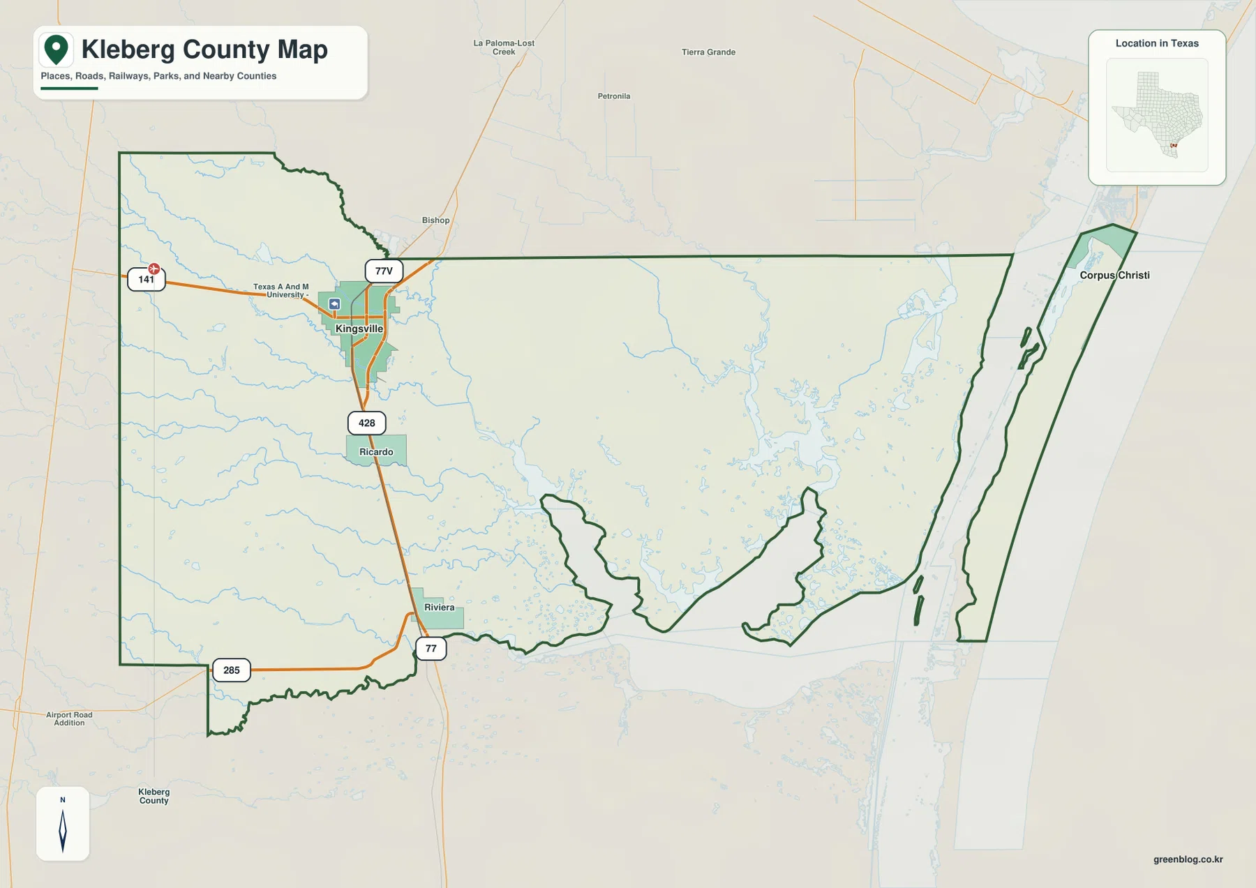
Kingsville is the most prominent place label on the general county map. It sits near the western side of the main county area, with Ricardo to the south and Riviera farther south along the same broad travel corridor. The eastern half looks much more open. Few settlement labels interrupt the map there, and the county boundary becomes increasingly shaped by bays, channels, and the coastal side of the county as it approaches Laguna Madre.
Corpus Christi is shown outside the county to the northeast, providing a useful regional reference without becoming the focus of the page. The map therefore gives two scales at once: a local view of Kingsville and nearby communities, and a wider view of how Kleberg County stretches toward the coast. This is especially useful when a simple county outline does not explain why the western road network and the eastern water-rich area look so different.
U.S. 77 gives the clearest route through the settled west
U.S. 77 is the easiest road to use as an orientation line. On the map it passes Kingsville and continues south through the Ricardo and Riviera area. Once that north-south route is identified, other numbered roads become easier to place. Route 141 extends west from the Kingsville area, 428 is marked south of the city, and 285 crosses the southern part of the map near Riviera. The road pattern is noticeably denser around Kingsville than across the broad eastern interior.
This makes the general map useful for practical location questions. A reader can first find Kingsville, then trace U.S. 77 toward Ricardo and Riviera, and finally see where cross routes branch away from that corridor. The same approach also prevents the large, lightly labeled eastern area from making the county seem empty or featureless; that part of the map contains far more hydrologic detail than road or settlement detail, which becomes clear in the water map below.
The city index intentionally keeps the focus on Kingsville
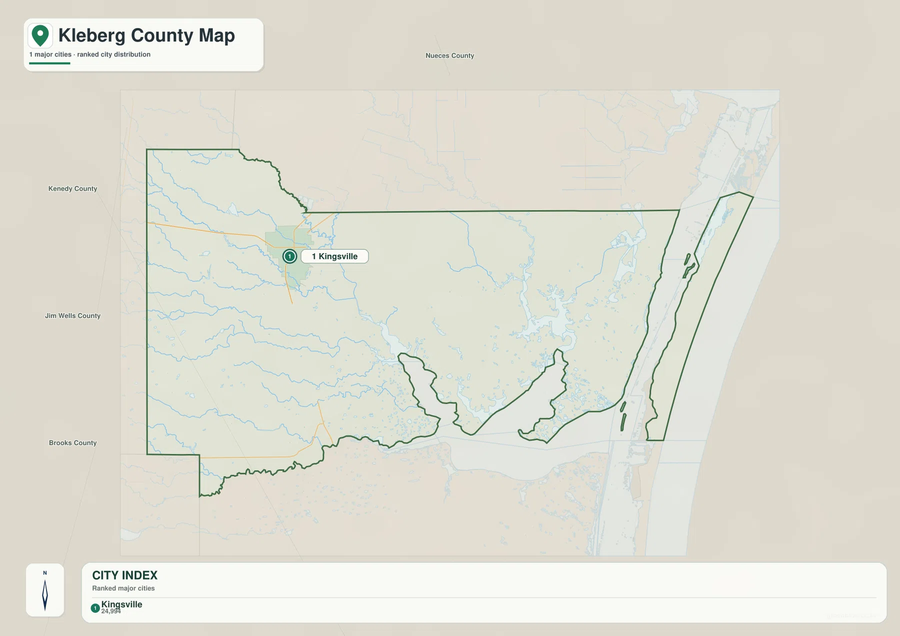
The city map is much simpler than the general map. In this package, Kingsville is the only ranked major city shown inside the county. That does not mean Ricardo or Riviera are absent from Kleberg County; both are visible on the broader county map. The city index is designed to reduce visual clutter and make the principal urban reference obvious, so Kingsville receives the single numbered marker.
Names of neighboring counties around the outside help with orientation. Nueces County appears to the north, Jim Wells County to the west, Brooks County to the southwest, and Kenedy County to the south. For a presentation or a quick regional locator, this stripped-down view may be easier to read than the road map. When the question shifts from “where is Kingsville?” to “how do I get from Kingsville toward Riviera?” the general map provides the needed road detail.
Creeks and small lakes fill in the interior between roads and coast
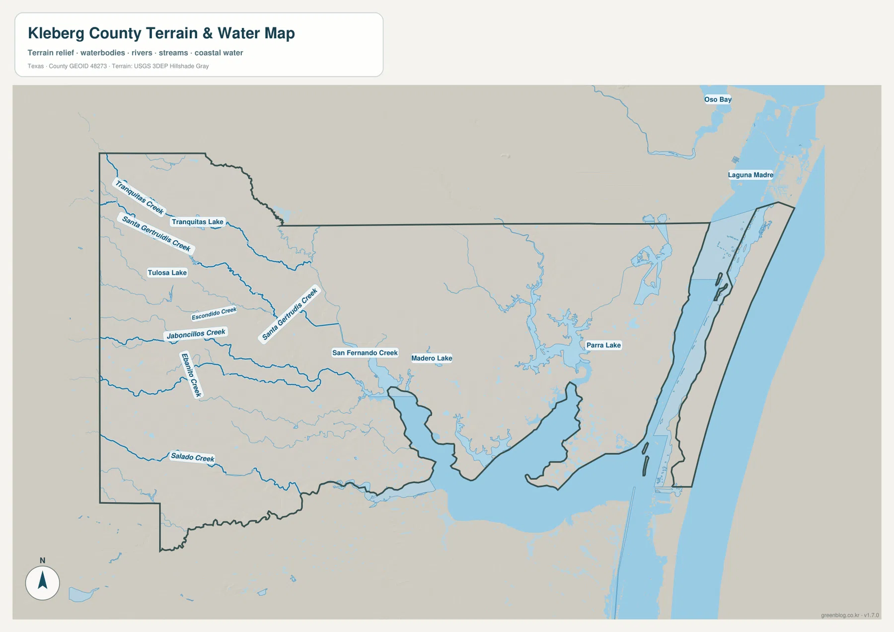
The terrain and water map adds many names that are not prominent on the general road view. Tranquitas Creek enters the northwestern part of the county near Tranquitas Lake, while Santa Gertrudis Creek runs across the western and central area. Tulosa Lake, Escondido Creek, and Jaboncillos Creek appear farther south and help show that the interior contains a network of small water features rather than a single dominant river.
San Fernando Creek is one of the most noticeable labeled channels in the central-southern part of the map. Madero Lake lies nearby, Parra Lake is farther east, and Salado Creek crosses the southwest. These labels are useful because they turn the pale blue lines on the general map into named reference points. A reader comparing roads and water can see that much of the county’s detailed geography lies between the main settlement corridor and the coastal water rather than directly along a major highway.
Laguna Madre is the largest water feature shown along the eastern side. It forms a strong visual contrast with the smaller inland creeks and lakes, and the county boundary follows a much more intricate shape in this area than it does across the western land boundary. Oso Bay is also labeled beyond the county to the northeast, serving as a surrounding coastal reference. For county-specific reading, however, Laguna Madre and the interior creeks are the more useful features to compare.
Elevation falls from the western side toward the coast
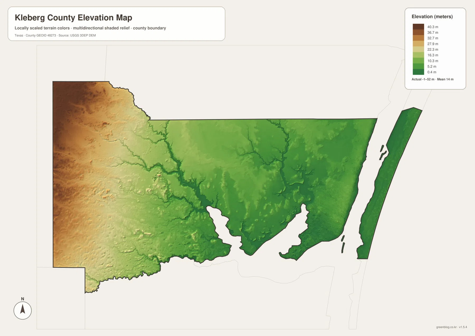
The elevation map reports an actual range of about -1 to 52 meters and a mean elevation of about 14 meters. Those values confirm that Kleberg County is generally low, but the color pattern still shows a clear internal change. Browns and tans occupy much of the west, indicating the higher part of the county, while greens become more extensive toward the center and east. The lowest colors are concentrated near the Laguna Madre side.
Relief around the creek channels is also visible. Lower, branching lines cut through the higher western surface and continue toward the broad lowlands farther east. When the elevation map is compared with the water map, Santa Gertrudis Creek, San Fernando Creek, and other drainage lines make more sense as parts of a gently descending landscape. The map is not intended to highlight named mountains or steep peaks; its strength is showing a gradual west-to-east change across a county whose total elevation range is modest.
Which map is most useful for a particular question?
For roads and community locations, start with the general county map. It contains the clearest combination of Kingsville, Ricardo, Riviera, U.S. 77, and the numbered cross routes. The city index is better when the goal is simply to place Kingsville within the county without extra labels. For streams and lakes, the terrain and water map is much more informative because it names features that are only faint lines on the general map. The elevation map is the best choice for comparing the higher western surface with the very low eastern side.
Using two maps together can answer questions that neither map handles as well alone. For example, locating Kingsville on the general map and then finding Santa Gertrudis Creek on the water map shows how the city-area road network sits among nearby drainage lines. Looking at Riviera on the road map and then switching to the elevation view shows how the southern settlement corridor lies within a generally low landscape. The shared county boundary makes these comparisons straightforward.
High-resolution files for labels, printing, and close comparison
The web previews are convenient for orientation, but some of the smaller names—such as Tranquitas Lake, Madero Lake, Parra Lake, or the numbered road markers—are easier to inspect in the downloadable files. The ZIP contains the four maps shown on this page as high-resolution A3 JPG images. Readers can keep the full set together or use only the road, city, water, or elevation view needed for a particular project.
Frequently Asked Questions
How can I quickly locate Kingsville, Ricardo, and Riviera?
Find U.S. 77 on the general county map first. Kingsville is the prominent northern community along that corridor, with Ricardo to the south and Riviera farther south. The city index simplifies the view even more by marking Kingsville as the single ranked major city.
Which named water features are easiest to identify?
The map labels Tranquitas Creek, Santa Gertrudis Creek, Escondido Creek, Jaboncillos Creek, San Fernando Creek, and Salado Creek, along with Tranquitas Lake, Tulosa Lake, Madero Lake, and Parra Lake. Laguna Madre is the dominant coastal water feature on the eastern side.
What elevation range does the Kleberg County map show?
The supplied elevation map lists an actual range of about -1 to 52 meters and a mean of about 14 meters. The western side is generally higher, while lower terrain becomes more widespread toward Laguna Madre.
Sources and Reference Data
- U.S. Census Bureau TIGER/Line Shapefiles — official boundary and transportation geometry used for geographic reference.
- USGS National Hydrography — official hydrography resources for streams, lakes, and other water features.
- USGS 3D Elevation Program — official elevation data program used for terrain information.
- USGS The National Map Viewer — an official map viewer for checking multiple geographic layers.
Map File Information
Download four high-resolution A3 JPG maps of Kleberg County in one ZIP file.
- Included Files: county map, city map, terrain and water map, elevation map
- File Type: JPG
Related Maps
- Starr County
- San Patricio County Texas map
- Willacy County Texas map
- Webb County Texas map
- Zapata County Texas map
Green Map creates custom-edited map images using open geographic data sources such as geoBoundaries, Natural Earth, OpenStreetMap, and government open data.
These maps are edited visual materials, not raw data files, and are provided for education, documents, presentations, and graphic reference.