The Calhoun County Florida Map is most useful when Blountstown, Altha, the state roads, and the county’s two major river settings are viewed together. Blountstown sits near the eastern side of the county and serves as the county seat, while Altha is farther north along State Road 71. State Road 20 crosses Blountstown from west to east toward the large river boundary with Liberty County. This page explains the county boundary and road map, the simplified city map, and the terrain-and-water map as separate resources. The matching high-resolution A3 JPG files can also be downloaded together in one ZIP from the map file box below.
Table of Contents
Blountstown Is the Best Starting Point for Reading the County
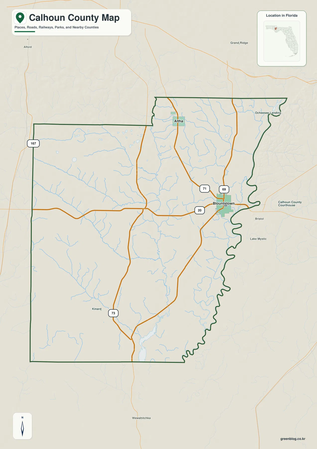
Calhoun County lies in the inland Florida Panhandle. Jackson County is to the north, Bay County to the west, Gulf County to the south, and Liberty County to the east. The county outline is especially distinctive on the eastern side, where the boundary follows the Apalachicola River rather than a simple straight survey line. Blountstown is located close to that river edge, so it provides a practical reference for connecting county government, transportation, and river geography on the same map.
The general county map also labels Altha in the north, Kinard in the southwest, and Ocheesee Landing near the northeastern side. Nearby places outside the county, including Bristol, Grand Ridge, Alford, and Wewahitchka, help show how Calhoun County fits into the surrounding Panhandle. This broader view matters because the county is rural and relatively low-density. A reader who looks only for a continuous urban area may miss the more important geographic pattern: small communities are separated by broad areas of forest, farmland, wetlands, and river-bottom country.
SR 20 and SR 71 Explain Most of the County’s Basic Road Orientation
State Road 20 is the clearest east-west reference. It enters from the Bay County side, passes through Blountstown, and continues east across the Apalachicola River toward Liberty County. State Road 71 provides the main north-south relationship between Altha and Blountstown before continuing south toward the Gulf County side of the region. When those two roads are located first, the rest of the county becomes much easier to place because the county seat, northern town, eastern river crossing, and western approach all fall into a simple directional framework.
The map also shows SR 69 and SR 73, which add connections beyond the two easiest reference roads. SR 69 reaches north from the Blountstown area, while SR 73 runs through the southwestern part of the county before meeting other routes. A 167 road marker appears on the western side as well. These roads should not be read like a dense metropolitan street grid. Their value on a county-scale map is that they show how small communities and rural areas connect to Blountstown, the county boundaries, and neighboring parts of the Panhandle.
Calhoun County does not have a Gulf of Mexico coastline, yet its road network places it between inland Northwest Florida and the Gulf Coast counties. Following SR 71 south brings the map toward Wewahitchka and Gulf County, while SR 20 provides a westward route toward Bay County and an eastward crossing toward Liberty County. This makes the county useful as a regional reference point: it is not a coastal destination itself, but it sits within the road network that links inland Panhandle communities with counties closer to the coast.
The City Map Highlights the Difference Between Blountstown and Altha
The city map deliberately keeps the settlement picture simple. It emphasizes Blountstown and Altha, the county’s two incorporated municipalities, instead of filling the page with every named community. Blountstown appears near the eastern side of the county, while Altha is noticeably farther north. Labels for Jackson, Liberty, Gadsden, Bay, and Gulf Counties around the map make the position of those two towns easier to understand in a regional setting.
The contrast also matches the county’s low population density. The existing county material cites a U.S. Census Bureau estimate of 13,289 residents on July 1, 2025, compared with 13,648 people counted in the 2020 Census. It also gives 567.34 square miles of land and a 2020 density of 24.1 people per square mile. Those figures help explain why the map does not resemble a suburban county with one continuous built-up corridor. Blountstown and Altha serve as recognizable centers, but large areas between and around them remain rural.
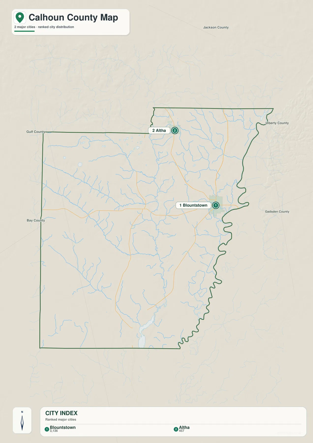
Blountstown is more than the largest label on this map. It is the county seat and the main governmental reference, which is why the courthouse and county administration are associated with it. Altha has a different role as a small town serving the northern part of the county. Other names on a detailed local map, such as Kinard, can still be useful for orientation, but they should not automatically be treated as incorporated municipalities. Keeping that distinction in mind prevents a long list of place names from obscuring the county’s actual municipal structure.
Chipola River, Creeks, and the Eastern River Edge Shape the Water Map
The terrain-and-water map gives the Chipola River much more attention than the general road map. It runs through the central part of the county and receives water from a network of smaller streams. Tenmile Creek is labeled in the northwest, while Fourmile Creek and Juniper Creek cross the western part of the map. Cypress Creek appears farther south, and Jim Bay is marked near the northwestern side. Together, these labels show that Calhoun County’s inland water geography is not defined by one river alone; many smaller channels feed the larger system.
The eastern side presents a different river setting. The Apalachicola River forms the major natural boundary with Liberty County. Near that side, the water map labels Three Bayou and Old River, reinforcing the impression of a broad river corridor with side channels and low-lying water features. Blountstown is close enough to the river that the county seat and the eastern water boundary can be understood together, especially where SR 20 crosses toward Liberty County. This relationship between town, road, and river is one of the most useful geographic ideas to take from the maps.
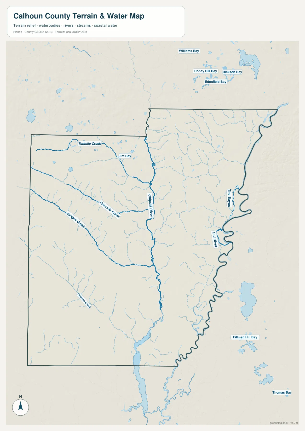
The Florida Department of Environmental Protection material included with the package describes the Middle Chipola River through Jackson and Calhoun Counties as a river corridor that passes farmland and forest, exposes limestone in places, and includes high banks, floodplain forest, and wet lowlands. That description helps explain why the western and central side of Calhoun County contains a mix of stream valleys and higher rural ground. Across the Apalachicola River in Liberty County, Torreya State Park is known for high bluffs and deep ravines. The park is not inside Calhoun County, but it is a useful neighboring reference for the stronger relief found along the eastern river valley.
This water map should be used as a geographic reference rather than as a flood, parcel, engineering, or navigation product. It shows where named rivers, creeks, bays, and related water features are located at county scale. It does not provide flood-zone boundaries, legal property lines, current water depth, or survey-grade measurements. For those purposes, a reader would need the appropriate official hazard, parcel, or engineering data rather than this general map.
Each Map Answers a Different Practical Question
The county map is the best choice when the question is “Where is this place relative to roads and county boundaries?” It combines Blountstown, Altha, several smaller place labels, state roads, streams, and neighboring areas in one view. The city map removes much of that detail and makes the two incorporated municipalities stand out. The water map does the opposite: it reduces the emphasis on cities and roads so the Chipola River, tributary creeks, bayous, and eastern river corridor are easier to follow.
For a school assignment or county profile, the general map can provide the opening overview and the water map can add a second layer of natural geography. A travel-planning document may benefit more from the road relationships around Blountstown, SR 20, and SR 71. A lesson about settlement can use the city map to show why Blountstown and Altha are separated by substantial rural space rather than being part of one urban cluster. Because the maps focus on different information, choosing the one that matches the task usually produces a clearer page than using all of them at once.
It is also important not to infer a missing map type. This package contains a county map, a city map, and a terrain-and-water map. It does not include an elevation map, so exact elevations, contours, or engineering-grade height differences cannot be taken from these files. Likewise, the road map does not show live traffic or construction. Keeping those limits clear makes the maps more useful because each can be used for the information it was actually designed to show.
The web previews are convenient for reading the article, but a larger file is preferable for print, classroom handouts, presentations, or documents where labels need to remain legible. The download archive contains the three high-resolution JPG maps that correspond to the county, city, and water views shown on this page. They can be used separately, so there is no need to place every map in the same project. The files are prepared at A3 size, giving more room for road numbers, community labels, streams, and boundary details than a small browser preview.
Frequently Asked Questions
Why are Blountstown and Altha the main places on the city map?
They are Calhoun County’s two incorporated municipalities. Blountstown is the county seat and lies near the eastern side of the county, while Altha is a smaller town farther north. The simplified city map emphasizes them so the county’s municipal structure is easy to see without a long list of unincorporated place names.
What is the major river along Calhoun County’s eastern side?
The Apalachicola River is the major eastern geographic reference and forms much of the natural separation from Liberty County. Blountstown is west of the river, and SR 20 crosses eastward, making the river both a county-edge reference and an important regional crossing.
Which smaller waterways are labeled on the water map?
The map labels Tenmile Creek, Fourmile Creek, Juniper Creek, and Cypress Creek, along with Jim Bay. Near the eastern side it also labels Three Bayou and Old River. These features are useful for county-scale orientation, but the map is not intended to replace flood, parcel, or navigation data.
Map File Information
Download one ZIP containing the three A3 high-resolution JPG files that match the county map, city map, and terrain-and-water map used on this page.
- Included Files: County map, city map, and terrain-and-water map JPGs
- File Type: ZIP containing 3 JPG files
Related Maps
Sources
- Calhoun County, Florida — county government and Blountstown administrative context
- U.S. Census Bureau QuickFacts — Calhoun County, Florida — population, land area, and density reference
- Florida Department of Transportation — Calhoun County — state-road context for SR 20, SR 69, SR 71, and SR 73
- Florida Department of Environmental Protection — Middle Chipola River — river corridor, limestone, floodplain, and wetland context
- Florida State Parks — Torreya State Park — neighboring Apalachicola River bluff and ravine context
Green Map creates custom-edited map images using open geographic data sources such as geoBoundaries, Natural Earth, OpenStreetMap, and government open data. These maps are edited visual materials, not raw data files, and are provided for education, documents, presentations, and graphic reference.