Dundy County occupies Nebraska’s southwestern corner, where Benkelman sits in a low river corridor below broad High Plains uplands. Haigler lies near the Colorado border to the west, while Parks and Max occupy the southern drainage country closer to Benkelman. The north and west are sparsely settled and higher, creating a strong contrast with the valleys that carry the Arikaree and Republican river systems. High-resolution map files are available for download in the section below.
This page explains the main settlements and roads, the ranked city distribution, Arikaree River, South Fork Republican River, Republican River, named creeks and canals, and an elevation range of about 865 to 1,120 meters. The original high-resolution JPG versions of the supplied maps can also be downloaded together in a ZIP for printing, classroom use, or personal reference.
Table of Contents
Benkelman anchors the low southern corridor near the county’s eastern side
Benkelman is the Dundy County seat. The county’s official website describes Dundy as Nebraska’s southwestern corner county, bordering both Colorado and Kansas. Benkelman lies in the lower southern part of the county near U.S. 34 and the junction of north-south state routes, making it the clearest reference point for the surrounding rural landscape.
Haigler is farther west near the Colorado line on the same U.S. 34 corridor. Parks lies between Haigler and Benkelman in the river country, while Max appears east of Benkelman near the Republican drainage. Most named settlements are concentrated in the south, leaving the higher northern interior without a comparable urban center.
Dundy County was authorized by the Nebraska Legislature in 1873 and formally organized in 1884 after having been attached to Hitchcock County for administrative purposes. It was named for federal judge Elmer Scipio Dundy. The county’s official history links early settlement to agricultural land near the Republican River and later growth to railroad access.
U.S. 34 ties Haigler, Parks, and Benkelman together along the southern valley
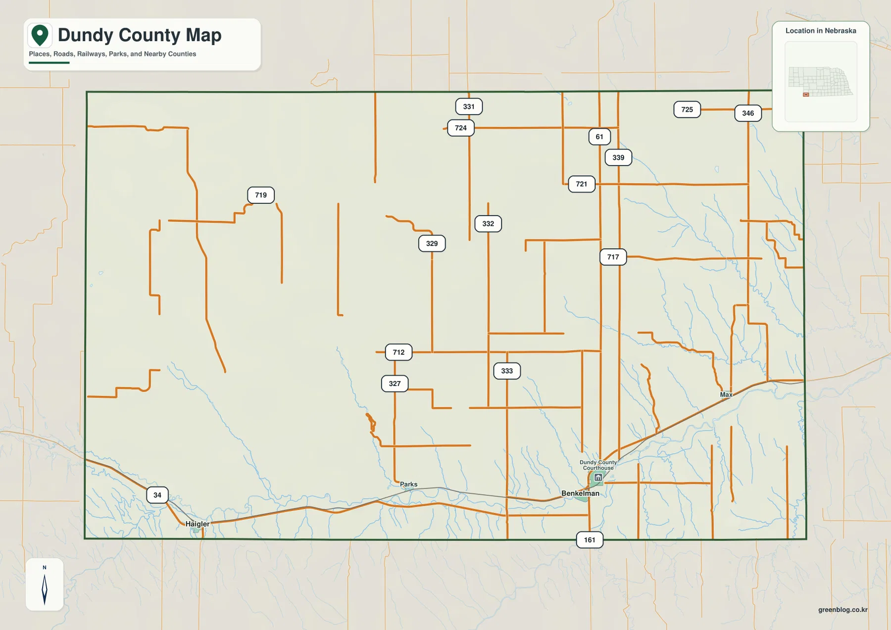
U.S. 34 is the strongest east-west road on the county map. It enters from Colorado near Haigler, continues through the Parks area, and reaches Benkelman before extending east. The route follows the same broad southern lowland used by the county’s main settlements and river corridors.
At Benkelman, Route 61 runs north into the rural interior and Route 161 continues south toward Kansas. County and local roads marked 331, 724, 721, 717, 333, 332, and 329 provide access across the central and northern areas, while 725 and 346 appear in the northeast. The western interior has a much sparser road pattern.
The contrast reflects both settlement density and terrain. Roads are more continuous in the southern river valleys, while long agricultural sections dominate the high plains to the north and west. The map is useful for orientation, but current closures, unpaved sections, construction, and travel times should be checked with live Nebraska transportation information.
The city map compares Benkelman and Haigler without mileage lines
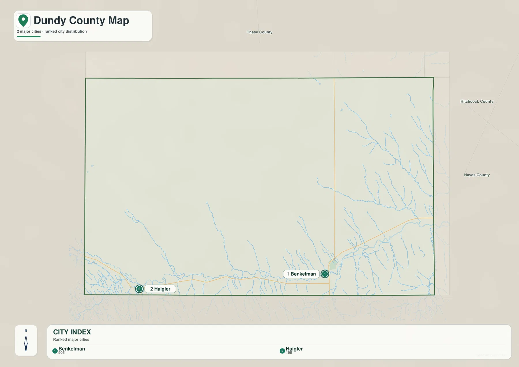
The city distribution map ranks Benkelman first and Haigler second. Benkelman sits near the southeastern side of the county, while Haigler is close to the southwestern border with Colorado. Both communities occupy the southern transportation and river corridor, but a long stretch of rural land separates them.
No connector line or mileage value appears on the supplied city map. The useful comparison is positional rather than numerical. Pairing it with the general road map shows that U.S. 34 provides the primary connection, while a current routing service is the better source for actual driving distance and travel time.
The values printed on the supplied map are 905 for Benkelman and 195 for Haigler. They belong to the ranked-city graphic rather than a continuously updated demographic table. Current population figures should be checked with the U.S. Census Bureau or Dundy County sources when needed.
Arikaree and Republican river corridors organize the southern drainage
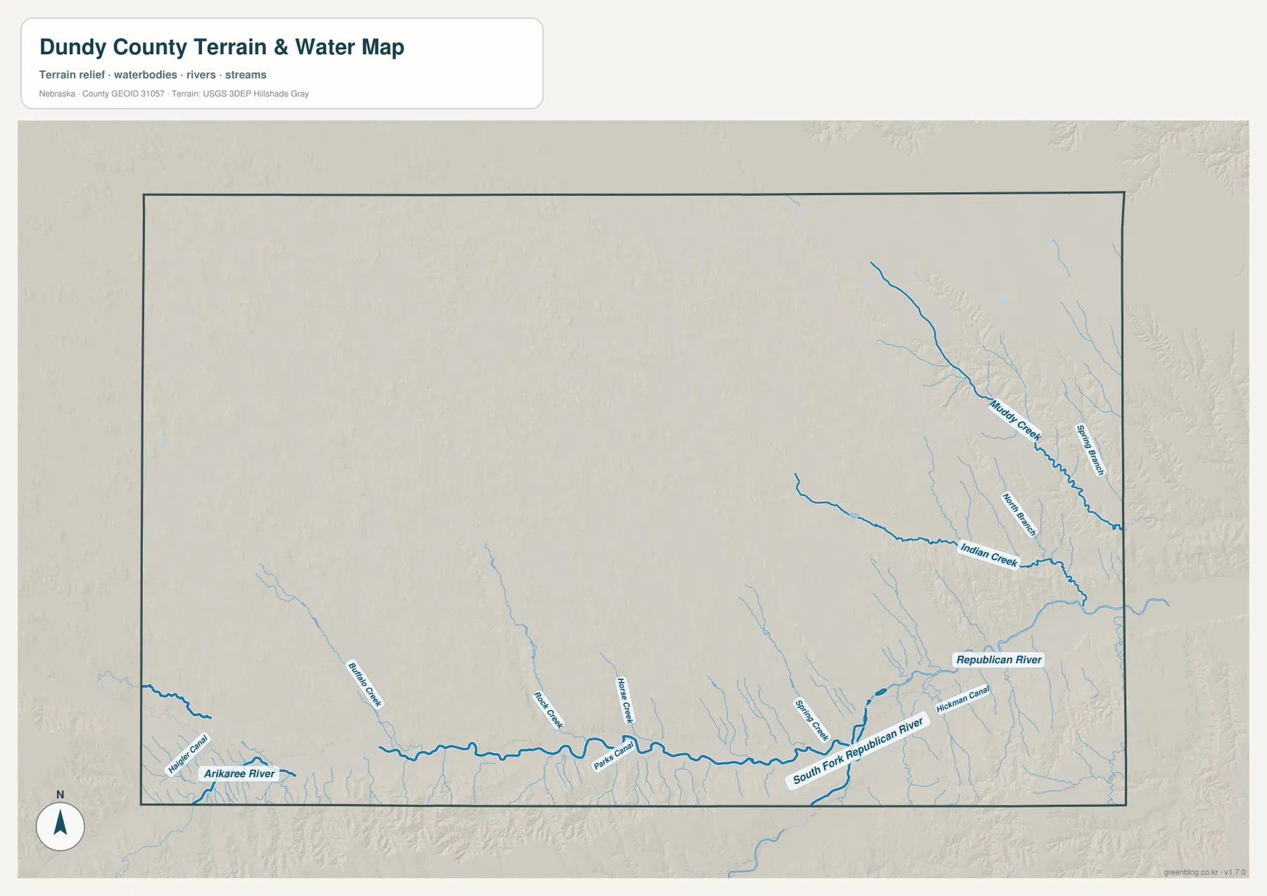
Arikaree River is the most prominent named watercourse on the southwestern side. It passes close to Haigler and continues east through the southern lowland, with Haigler Canal visible nearby. Farther east, Parks Canal and tributaries such as Rock Creek, Horse Creek, and Buffalo Creek feed into the same general river country.
South Fork Republican River is clearly labeled east of Benkelman, and Republican River appears farther east. Hickman Canal follows part of this lower corridor. Natural streams and managed irrigation channels therefore occupy the same broad valley, reflecting the importance of water to agriculture in this dry High Plains environment.
The northeastern part of the county has a different drainage pattern. Muddy Creek runs southeastward through a deeply dissected valley, and Indian Creek joins the eastern drainage system from the central interior. Spring Branch and North Branch appear among the smaller tributaries cut into the upland surface.
This water map is intended for geographic reference. It does not define flood zones, legal water rights, parcel boundaries, current canal operation, water depth, navigability, or public access. Those questions require current information from USGS and the responsible regional water agencies.
The county descends roughly 255 meters from western uplands to eastern valleys
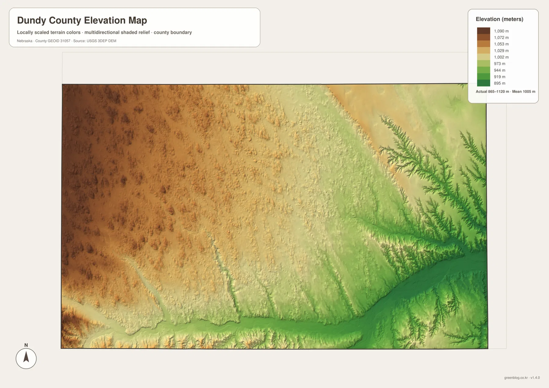
The elevation map reports an actual county-wide range of approximately 865 to 1,120 meters, with a mean near 1,005 meters. The highest brown terrain covers much of the west and northwest, while yellows and greens become increasingly common toward the east. Overall relief is about 255 meters.
Arikaree River and South Fork Republican River form long lower corridors across the south. The Benkelman-to-eastern county section becomes especially low, and the Republican River valley broadens toward the east. Around Haigler, the river corridor is also visibly lower than the surrounding plains.
Muddy Creek and Indian Creek create a branching set of low green valleys in the northeast. Those incised channels show that even a High Plains county can contain substantial local relief. Comparing the water and elevation maps makes the connection between named creeks and low terrain especially clear.
The elevation colors are scaled locally for Dundy County and should be used to compare locations within this map. Similar shades on another county map may represent different absolute heights. The generalized surface is not survey-grade information for engineering, construction, drainage design, or property work.
County organization and railroad growth established Benkelman as the center
Dundy County’s official history says the county was authorized in 1873 and organized in 1884. Early settlers were attracted to land along the Republican River, and railroad construction later accelerated local growth. The county was named for Judge Elmer Scipio Dundy, a prominent federal judge associated with Nebraska’s early history.
History Nebraska’s place-name records note that the Benkelman post office was renamed from Collinsville in 1885. The town was named for J. G. Benkelman, a local stockraiser, by officials associated with the Chicago, Burlington and Quincy Railroad. Benkelman’s later role as the county seat fits its location along the southern transportation and river corridor.
Rock Creek Fish Hatchery uses spring water near Parks
Nebraska Game and Parks says Rock Creek State Fish Hatchery was founded in 1924 at the headwaters of Rock Creek to use the area’s abundant cold spring flow. The facility raises rainbow trout and several other fish species and contributes to stocking programs across Nebraska.
Rock Creek appears on the supplied water map in the south-central part of the county near Parks. Together with Parks Canal, Horse Creek, and Buffalo Creek, it shows that this part of Dundy County contains a concentrated network of springs, streams, and irrigation features within the broader semi-arid High Plains landscape.
Use U.S. 34 and the Republican drainage as two simple map anchors
For basic orientation, start at Benkelman and follow U.S. 34 west through Parks toward Haigler. Then use Route 61 north from Benkelman and Route 161 south toward Kansas to understand the county’s main road structure. The city map provides a simplified comparison of Benkelman and Haigler when minor roads are not needed.
For physical geography, begin with Arikaree River in the southwest, continue east along the South Fork Republican and Republican river system, and then move north to Muddy and Indian creeks. The elevation map explains the same transition with high brown terrain in the west and lower green valleys toward the east and south.
For printing or classroom display, the downloadable high-resolution JPG files preserve more road numbers, creek names, canal labels, and local relief detail than the web previews. The county map emphasizes roads and settlements, the city map compares the two ranked communities, the water map shows river and canal systems, and the elevation map highlights the broad west-to-east drop.
Frequently Asked Questions
Does the city map show the distance between Benkelman and Haigler?
No. The supplied city map ranks and locates Benkelman and Haigler, but it does not include a connector line or mileage value. Use U.S. 34 on the road map for relative position and a current routing service when actual driving distance is needed.
Where is the lowest terrain in Dundy County?
The lowest broad terrain lies in the eastern and southeastern Republican River drainage and in the main southern river valleys. The county-wide elevation range is about 865 to 1,120 meters, with higher plains becoming more common toward the west and northwest.
Can the water map be used for flood or water-right decisions?
No. It is a geographic reference showing Arikaree River, Republican River, Muddy Creek, Indian Creek, and canals. Flood risk, water rights, parcel boundaries, current flow conditions, and access questions require current authoritative records.
Map File Information
The ZIP contains the original high-resolution JPG files for the Dundy County boundary and road map, city distribution map, terrain and water map, and elevation map.
- Included Files: Use only the versions confirmed in the article and supplied images
- File Type: Use the confirmed download contents
- Intended Use: Printing, education, presentations, and map-based projects
Related Maps
Sources and references
- Dundy County – About Our County
- Dundy County official website
- History Nebraska – Nebraska Place Names
- Nebraska Game and Parks – Rock Creek Fish Hatchery
- USGS National Hydrography
- USGS 3D Elevation Program
These maps are intended for geographic reference. For legal boundaries, land ownership, flood determinations, water rights, road conditions, construction, surveying, or other decisions requiring current authoritative information, consult Dundy County and the responsible state or federal agency.
Green Map creates custom-edited map images using open geographic data sources such as geoBoundaries, Natural Earth, OpenStreetMap, and government open data. These maps are edited visual materials, not raw data files, and are provided for education, documents, presentations, and graphic reference.