Download the McIntosh County Georgia Map set when you need a printable view of Darien, the county road pattern, coastal waterways, and low-lying terrain along Georgia’s Atlantic coast. The four supplied maps use the same county boundary but emphasize very different features. The general county map labels Darien, Eulonia, Crescent, Thomas Landing, numbered roads, and numerous streams. The water map brings Sapelo River, Barbour Island River, Mud River, Doboy Sound, South Altamaha River, Altamaha River, and the Atlantic Ocean to the foreground, while the elevation map reports an actual range of roughly -2 to 29 meters with a mean near 3 meters. The ZIP contains four high-resolution A3 JPG files, and the page uses WEBP previews for faster browser viewing.
McIntosh County is better understood through its coast and water than through a long list of cities. The ranked city graphic highlights only Darien, yet the county map shows several smaller place labels that help with orientation. East and south of the inland road corridors, the outline becomes highly irregular as tidal rivers, sounds, narrow channels, and coastal landforms break up the edge of the county. The elevation colors add another clue: broad green areas dominate the coastal and river margins, while a few narrow ridges rise above the surrounding low ground. Reading those layers together gives the county a much more distinctive identity than a generic boundary map could provide.
Table of Contents
Darien provides the road and boundary frame for the county
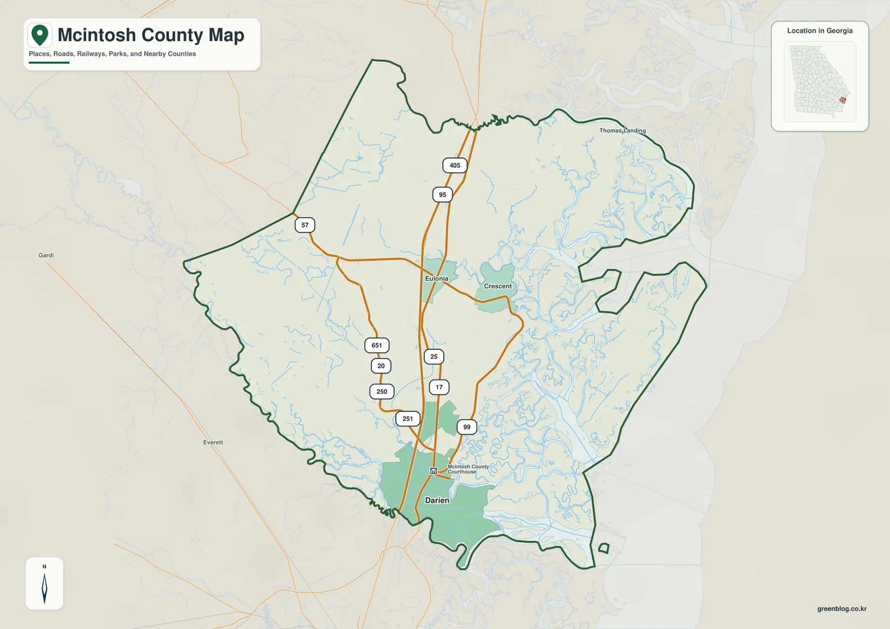
Darien is the strongest reference point on the general county map. It sits in the southern part of McIntosh County, just below the McIntosh County Courthouse label, with roads marked 17 and 99 passing nearby. Farther north, the road marked 25 continues along the same broad north–south zone, and the long corridor marked 95 crosses much of the county from the northern boundary toward Darien. A second north–south label, 405, appears in the northern interior close to that corridor. These markings make it easy to see how the inland side of the county connects north and south before the landscape opens into a much more fragmented coastal edge.
Eulonia is labeled near the middle of the county, where the north–south road pattern meets an east–west route. Crescent lies farther east, close to the point where streams and coastal channels become much denser. The western interior includes road numbers 57, 651, 20, 250, and 251, while 25 and 17 help orient the central and southern sections. The map is most useful for relative position rather than for interpreting road jurisdiction or current traffic conditions, because the graphic focuses on county-scale geography rather than a complete navigation network.
The boundary itself deserves attention. The western side has several long land-based segments, but the eastern side becomes deeply indented by water. The northeastern outline bends around coastal channels near Thomas Landing, and the southern edge follows a complex river-and-marsh margin. Gardi and Everett appear outside the county to the west, providing additional orientation beyond the boundary. The contrast between the simpler inland edge and the irregular coastal edge is one of the clearest visual clues that McIntosh County is a coastal county rather than a rectangular inland jurisdiction.
The ranked city map singles out Darien
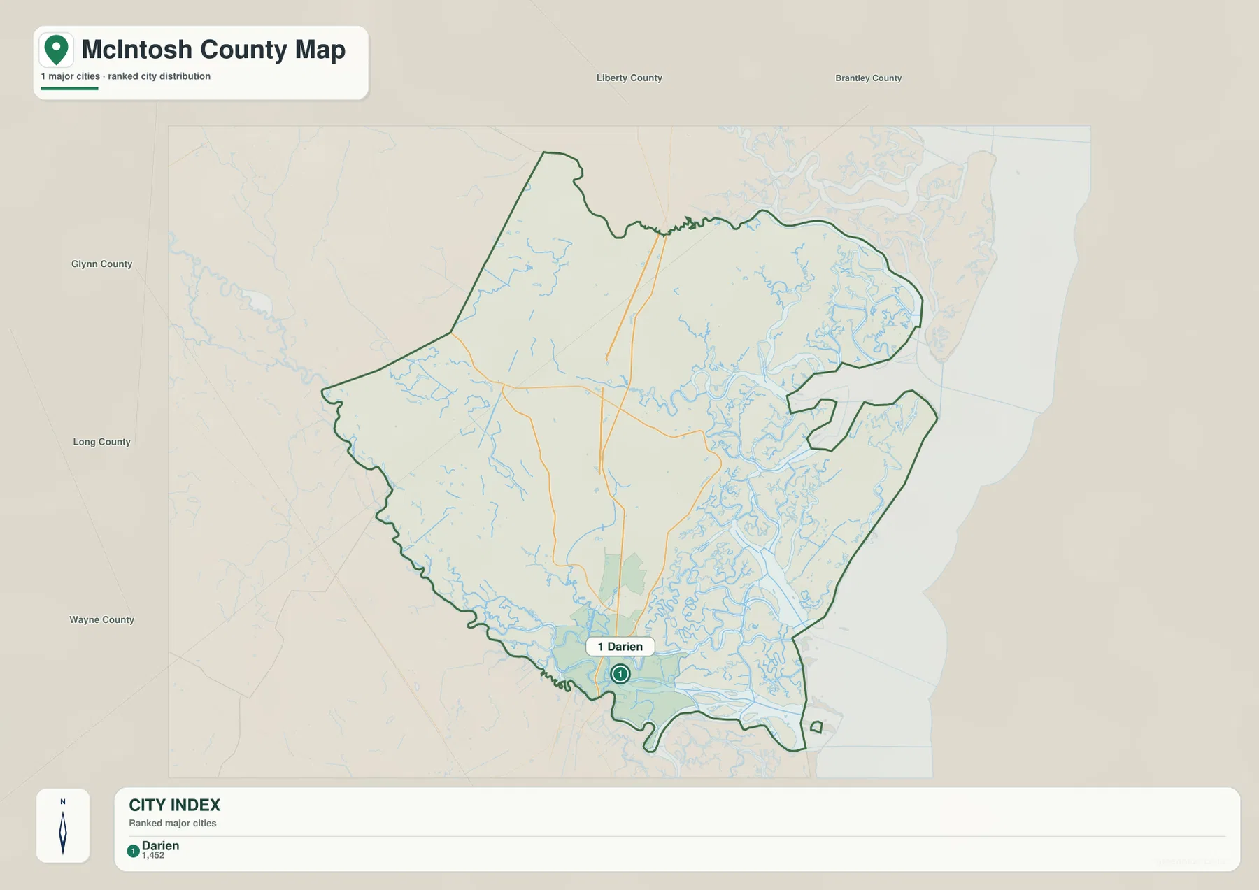
The city-distribution map is intentionally much simpler than the general county view. It states that one major city is included, and Darien is the only place given a ranked marker. The CITY INDEX prints a value of 1,452 beside Darien. Because the graphic does not identify the statistical year or the source of that number, it is best treated as the value shown on this particular map rather than as a claim about the latest population. A current Census source should be used when an up-to-date population figure is required.
Darien’s position is more important than the printed number for understanding the map. The city lies near the southern edge of the main inland landmass, while a broad zone of waterways and coastal landforms spreads to the east and southeast. The large northern interior is much less urban in appearance. This makes Darien a useful hinge between the inland road system and the low, water-dominated coastal section of McIntosh County.
Neighboring county labels surround the outline on this graphic. Glynn County appears to the west, Long and Wayne Counties are shown farther southwest and west, and Liberty and Brantley Counties are labeled across the top. Those names help establish regional direction without crowding the county interior with additional settlement labels. The map does not provide connector mileage or driving time, so it should be paired with a current road source for actual travel planning.
Sapelo and Altamaha waterways dominate the eastern and southern county
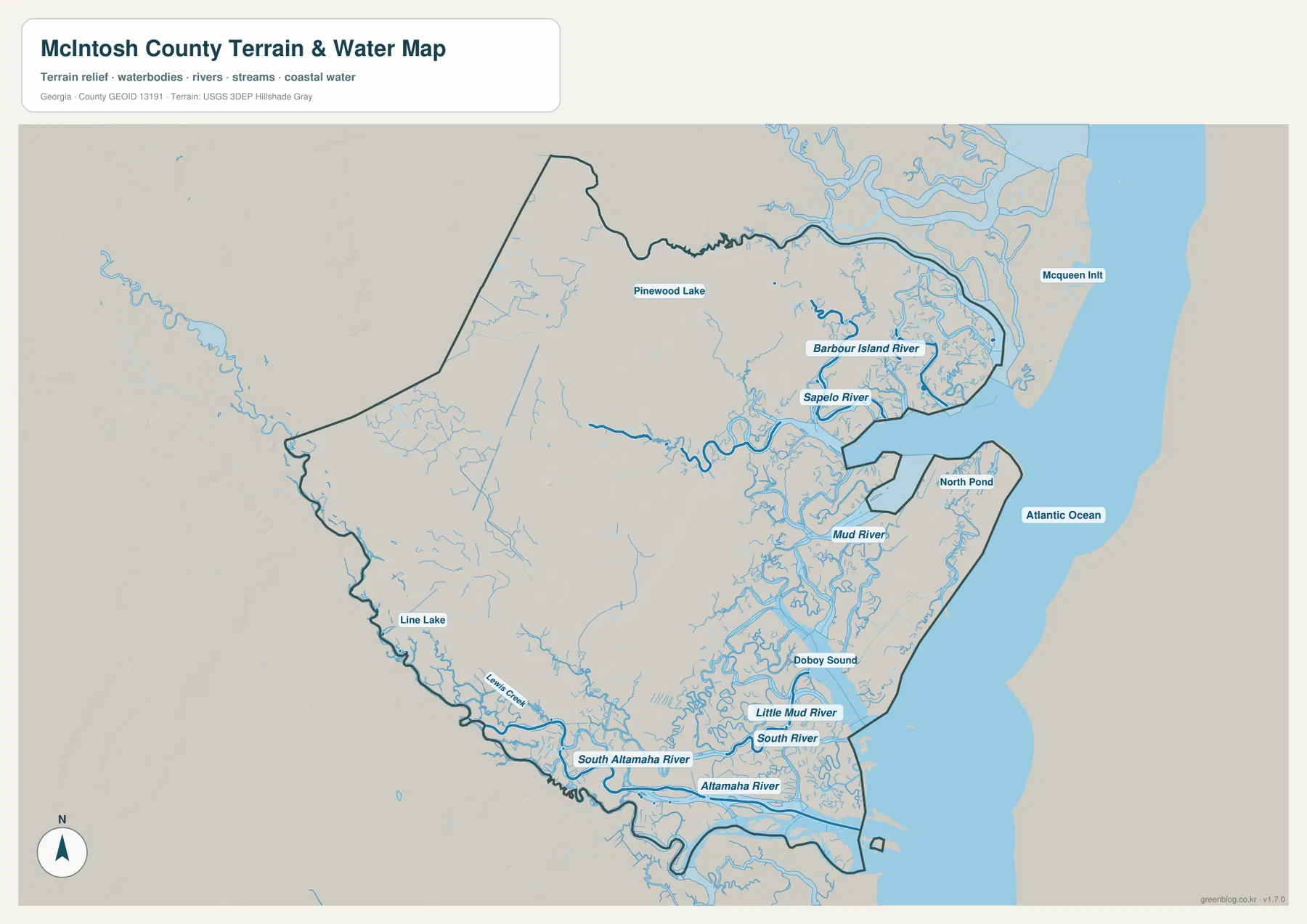
The terrain-and-water map is the layer that most clearly explains McIntosh County’s coastal geography. Sapelo River and Barbour Island River are labeled in the northeastern part of the county, with Mcqueen Inlt farther toward the ocean. The Atlantic Ocean fills the large blue area to the east. Between the inland boundary and open water, dozens of smaller channels twist through the coastal zone. Pinewood Lake and North Pond appear as smaller named water bodies, adding useful local references within a map otherwise dominated by rivers, sounds, and tidal-looking channels.
Moving south, Mud River is labeled near the center-right of the county, followed by the broader water of Doboy Sound. Little Mud River and South River appear farther down the coast. At the southern edge, South Altamaha River and Altamaha River form major named channels along a complicated boundary of river branches and low land. Lewis Creek and Line Lake are visible toward the southwestern side, showing that the drainage network reaches inland as well as along the ocean-facing margin.
The important pattern is the repeated splitting and rejoining of watercourses. The map does not present one river simply cutting the county in half; instead, the eastern and southern portions are divided by many named and unnamed channels. That structure explains why the county outline contains narrow projections, embayments, and separated coastal pieces. The graphic is a location reference for water features, not a regulatory flood map or marine chart. It does not supply flood probabilities, tidal stage, navigable depth, or legal waterfront boundaries.
Very low coastal relief is broken by a few narrow higher ridges
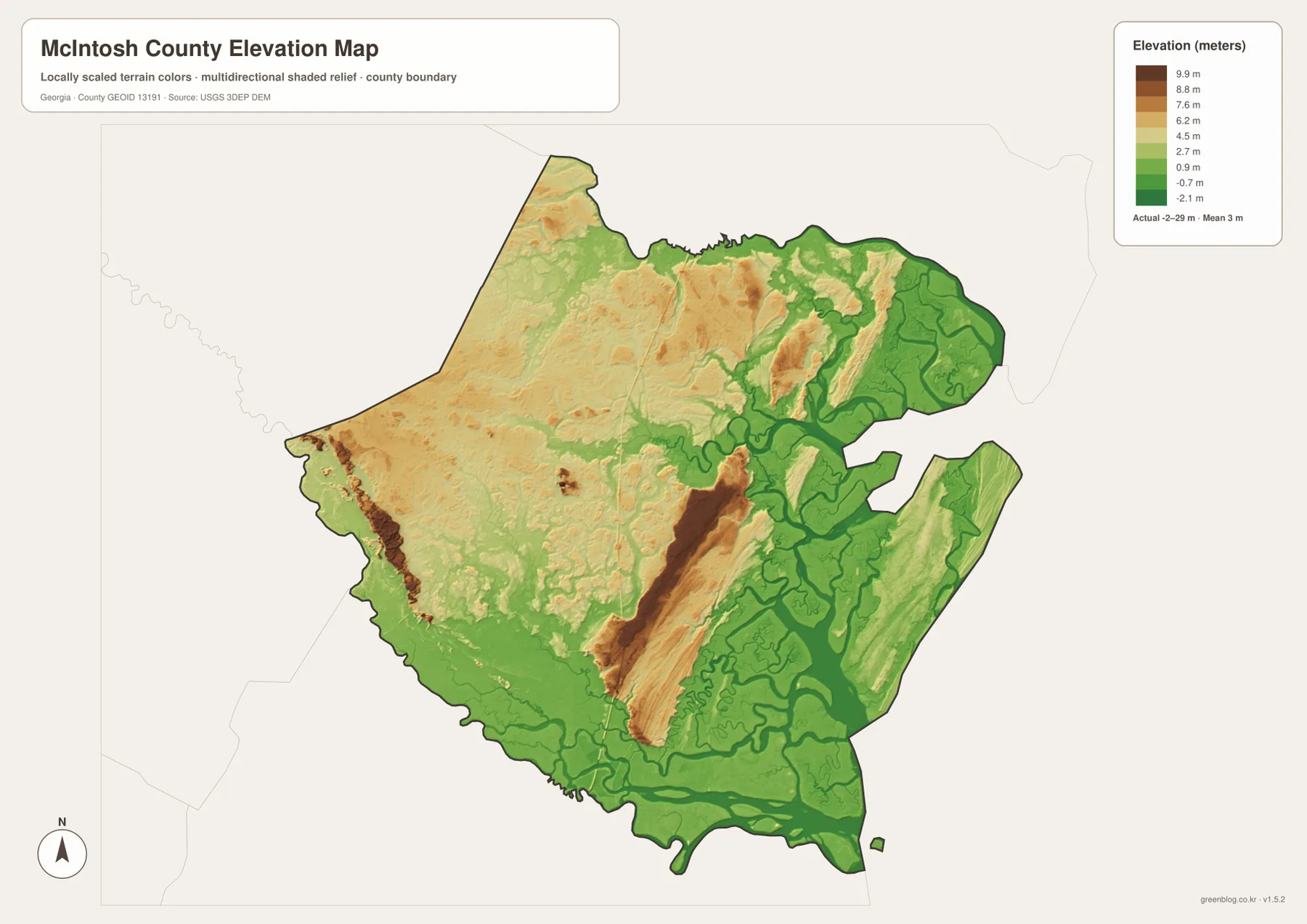
The elevation map reports an actual county range of about -2 to 29 meters and a mean near 3 meters. Green represents the lower end of the locally scaled range, while yellow, orange, and brown indicate progressively higher ground. Much of the eastern coastal area and the southern Altamaha margin is green, and the northeastern water-rich section is also dominated by low colors. Even before individual elevations are considered, the overall color balance shows that McIntosh County is overwhelmingly low compared with Georgia counties farther inland.
The most striking contrast is a long, narrow brown ridge in the south-central interior. It extends roughly north–south through a much broader field of low green terrain. Smaller bands of relatively higher ground appear in the eastern coastal landmass, and the northern and northwestern interior contains a mixture of yellow and orange patches rather than one uniform elevation. These features are not high mountains; they stand out because the surrounding landscape is so low and the map is scaled to local differences.
Comparing the elevation and water maps helps explain the green areas. Low colors spread around Sapelo River, Mud River, Doboy Sound, and the Altamaha system, where channels and marshy-looking lowlands dominate the map. The elevation layer is appropriate for county-scale comparison, but it is not a substitute for a survey or a flood-hazard product. A specific property, road project, or emergency decision requires more detailed elevation and hazard information than this overview provides.
Darien sits where the inland road network meets the water-shaped coast
Looking across the layers, Darien is more than a county-seat label. The general map shows it near roads 17 and 99, with the north–south road system extending inland from the city. The water map shows a very different setting around the same part of the county: river branches and coastal channels are dense immediately to the east and south. On the elevation map, those water-rich areas are mostly low green terrain. The combination makes Darien a natural reference point between a more continuous inland road corridor and a fragmented coastal landscape.
Eulonia and Crescent illustrate the same transition farther north. Eulonia sits closer to the inland road pattern, while Crescent is positioned nearer the dense waterways of the eastern side. The water map reveals the Sapelo River system beyond that area, and the elevation layer shows broader low ground toward the coast. This is why a single county map cannot answer every geographic question well: place names and roads are easiest to see on one layer, while the coastal structure becomes much clearer on the others.
The existing county source material notes that McIntosh County was established in 1793 and connects local history with the Altamaha River delta, coastal marshes, shrimping, Gullah Geechee culture, and coastal conservation. Those themes are not plotted as separate attractions on the downloadable maps, but the physical setting helps explain why water and the coast are so prominent in the county’s story. For a specific cultural site or visitor destination, use the county map for broad orientation and then consult the relevant official or local source for detailed directions.
Select the map by the feature you need to see
The general county map is the quickest way to place Darien, Eulonia, Crescent, the major numbered roads, and the irregular boundary in one frame. The city map is better when the goal is simply to see Darien’s position as the single ranked major city. The water map is the strongest choice for Sapelo River, Doboy Sound, Mud River, the Altamaha channels, lakes, and coastal water. The elevation view adds a different answer by showing where the broad lowlands lie and where narrow ridges rise above them.
| Map | Best for |
|---|---|
| County map | Darien, Eulonia, Crescent, numbered roads, streams, and the county boundary |
| City map | Darien as the ranked major city and regional orientation around the county |
| Water map | Sapelo River, Doboy Sound, Mud River, Altamaha channels, lakes, and the Atlantic coast |
| Elevation map | About -2 to 29 m of relief, broad coastal lowlands, and narrow higher ridges |
The WEBP images in the article are convenient for quick browser viewing. If you want to print the maps, enlarge labels, or compare the water and elevation patterns side by side, use the original JPG files instead. The ZIP below contains four high-resolution A3 JPG maps for the county, city, water, and elevation views.
Frequently Asked Questions
Why is Darien the only ranked major city on the city map?
The city-distribution layer uses a narrower ranking than the general county map. Darien is the only place given a ranked city marker, while the general map also labels places such as Eulonia and Crescent for orientation. The difference reflects the purpose of the two graphics rather than a contradiction between them.
What does the -2 meter value on the elevation map mean?
The map reports an actual county elevation range of roughly -2 to 29 meters. Because McIntosh County includes extremely low coastal and estuarine terrain, some modeled values can fall near or below zero. That value alone does not identify a flood zone or predict whether a particular property will flood.
Can the water map be used as a flood or tidal-hazard map?
No. It is a location reference for rivers, sounds, lakes, coastal water, and smaller channels. Flood probabilities, tidal levels, evacuation guidance, navigable depth, and legal waterfront boundaries require dedicated official sources.
Sources for McIntosh County, boundaries, water, and elevation
County background can be checked through Census and Georgia reference sources, while the federal data pages below document widely used boundary, hydrography, and elevation datasets relevant to the four map themes.
- U.S. Census Bureau QuickFacts – McIntosh County, Georgia
- New Georgia Encyclopedia – McIntosh County
- U.S. Census Bureau TIGER/Line Shapefiles
- USGS National Hydrography
- USGS 3D Elevation Program
Map File Information
This ZIP contains high-resolution A3 JPG versions of the McIntosh County county map, city map, water map, and elevation map.
- Included Versions: County, city, water, and elevation
- Included Files: Four high-resolution A3 JPG maps
Related Maps
Green Map creates custom-edited map images using open geographic data sources such as geoBoundaries, Natural Earth, OpenStreetMap, and government open data. These maps are edited visual materials, not raw data files, and are provided for education, documents, presentations, and graphic reference.