You can download four original high-resolution A3 JPG maps of Clinch County in one ZIP from this page: a county map, city map, water map, and elevation map. Clinch County covers a broad part of southeastern Georgia where a small group of towns sits well apart from the wet, low-lying country around the western edge of the Okefenokee. Homerville is the main reference point for roads and local services, while Fargo lies much farther southeast near the Suwannee River.
The maps are most useful when read together. The county map establishes the road network and neighboring areas, the city map makes the long gap to Fargo obvious, the water map shows why the southeast looks so different from the northern settlements, and the elevation map confirms that the county is a low-relief Coastal Plain landscape rather than mountainous terrain. Each view answers a different practical question without treating the map as a parcel, flood, or survey product.
Table of Contents
Homerville, major roads, and the county boundary
Homerville sits near the north-central part of Clinch County and is the clearest starting point for reading the road network. Several numbered routes converge there and then spread toward Du Pont to the west, Argyle to the northeast, and Fargo to the southeast. The county map labels US 84 and US 441 as well as routes 37, 38, 89, 94, 100, 122, 168, 177, 187, and 221. Cogdell also appears in the north, giving the map a little more local context than a simple four-city diagram.
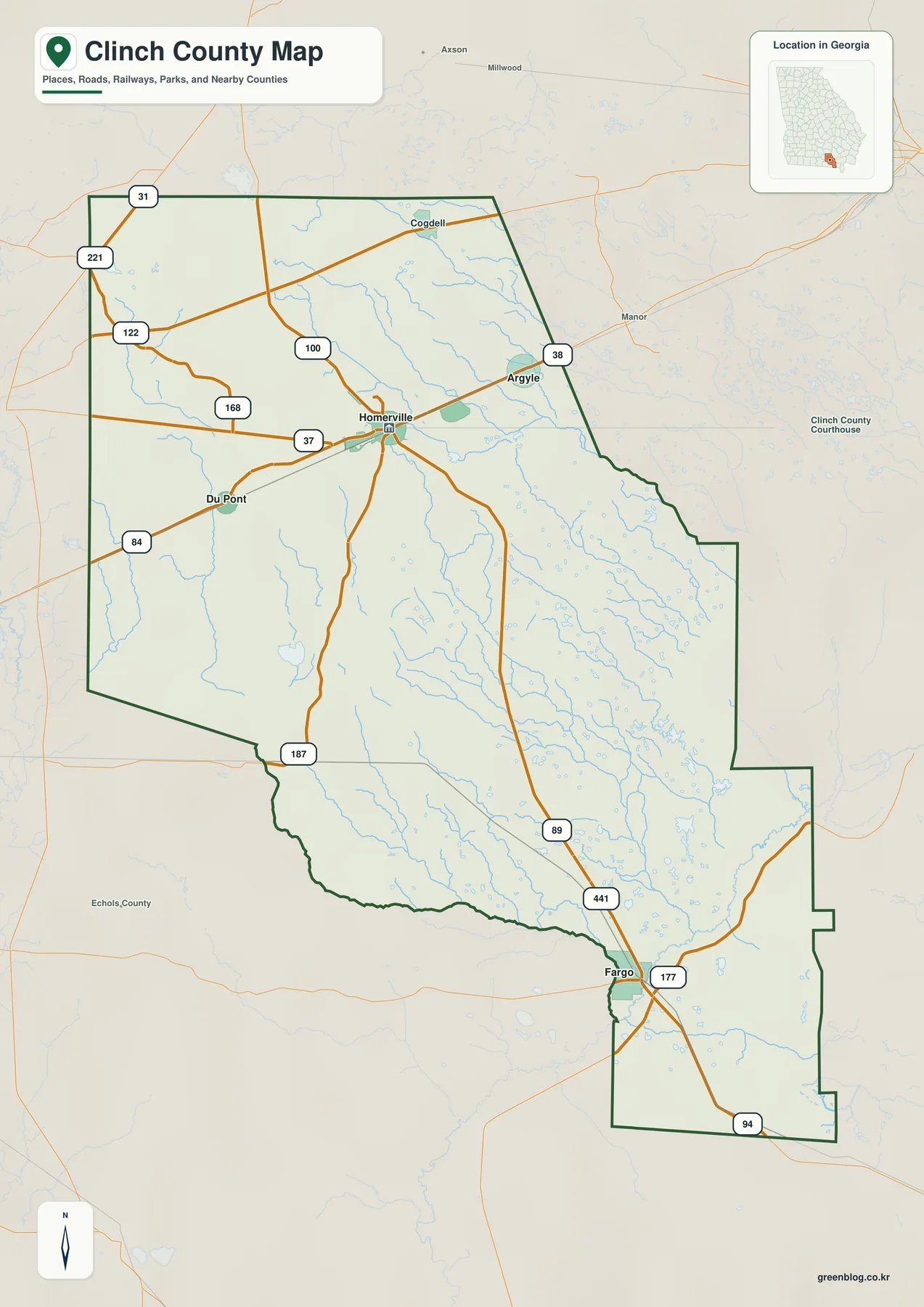
The county borders Atkinson County to the north, Ware County to the east, Lanier County to the west, and Echols County toward the southwest. Its southern edge meets Florida, which matters when following US 441 beyond Fargo. The map is useful for seeing those broad relationships, but the dark county line should not be mistaken for municipal boundaries, individual property lines, refuge management units, or wetland jurisdiction.
Homerville’s importance on the page comes from both administration and transportation. The community serves as the county seat and sits where the northern east-west corridor intersects the route running south toward Fargo and Florida. That makes it an easy visual anchor: Du Pont lies west of it, Argyle northeast of it, and the county’s largest stretch of lightly settled land extends toward the southeast.
How far the main places spread from Homerville
The city-connections map uses Homerville as its hub. Argyle is shown roughly 6 miles away in a straight line, Du Pont about 8 miles away, and Fargo about 27 miles away. Those numbers are direct point-to-point distances, not driving mileage. They are useful for comparing relative spacing, but road curves, route choice, and access conditions can make an actual trip longer.
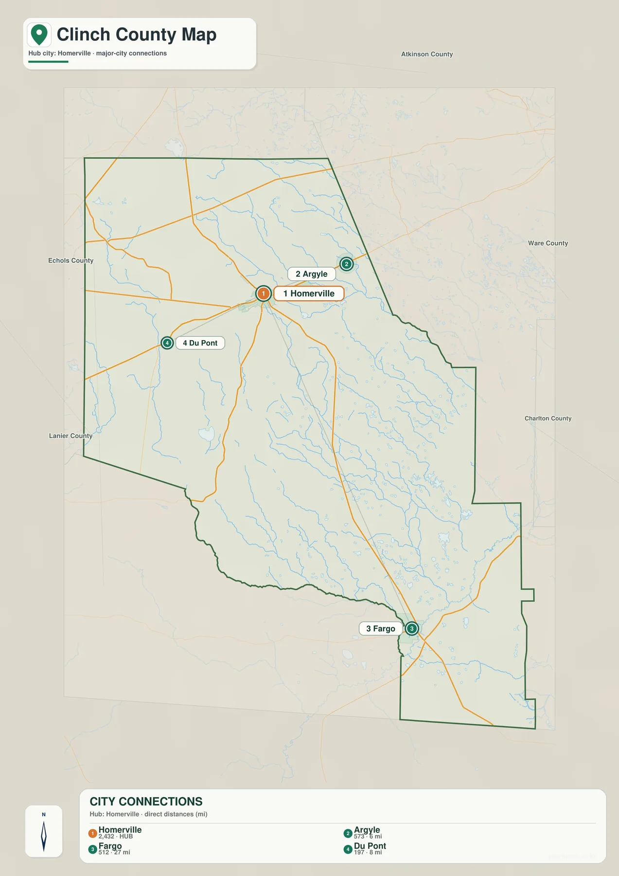
This spacing helps explain the county’s settlement pattern. Homerville, Argyle, and Du Pont occupy the northern road network within a relatively compact part of the county, while Fargo is separated from them by a much larger expanse of forested and wet terrain. The older county material identifies Homerville and Fargo as cities and Argyle and Du Pont as towns. Smaller communities also exist, but the numbered city map intentionally focuses on these four incorporated places.
For orientation, the city map is often easier to read than the detailed road map because it removes most local labels. It quickly answers whether a place is north, west, or southeast of Homerville and gives a sense of how different Fargo’s position is from the northern communities. For travel planning, however, the county road map and current navigation data are still necessary.
Suwannee River, creeks, bays, and ponds across Clinch County
Water becomes a dominant part of the map toward southeastern Clinch County. The Suwannee River is the best-known feature, appearing near the Fargo side of the county after leaving the Okefenokee area. The water map also labels Cane Creek, Suwannoochee Creek, Jones Creek, and Tatum Creek, along with smaller branches and a series of named ponds or bays such as Bunkle Bay, Scoggin Bay, Long Pond, Lake Verne, and Dickerson Millpond.
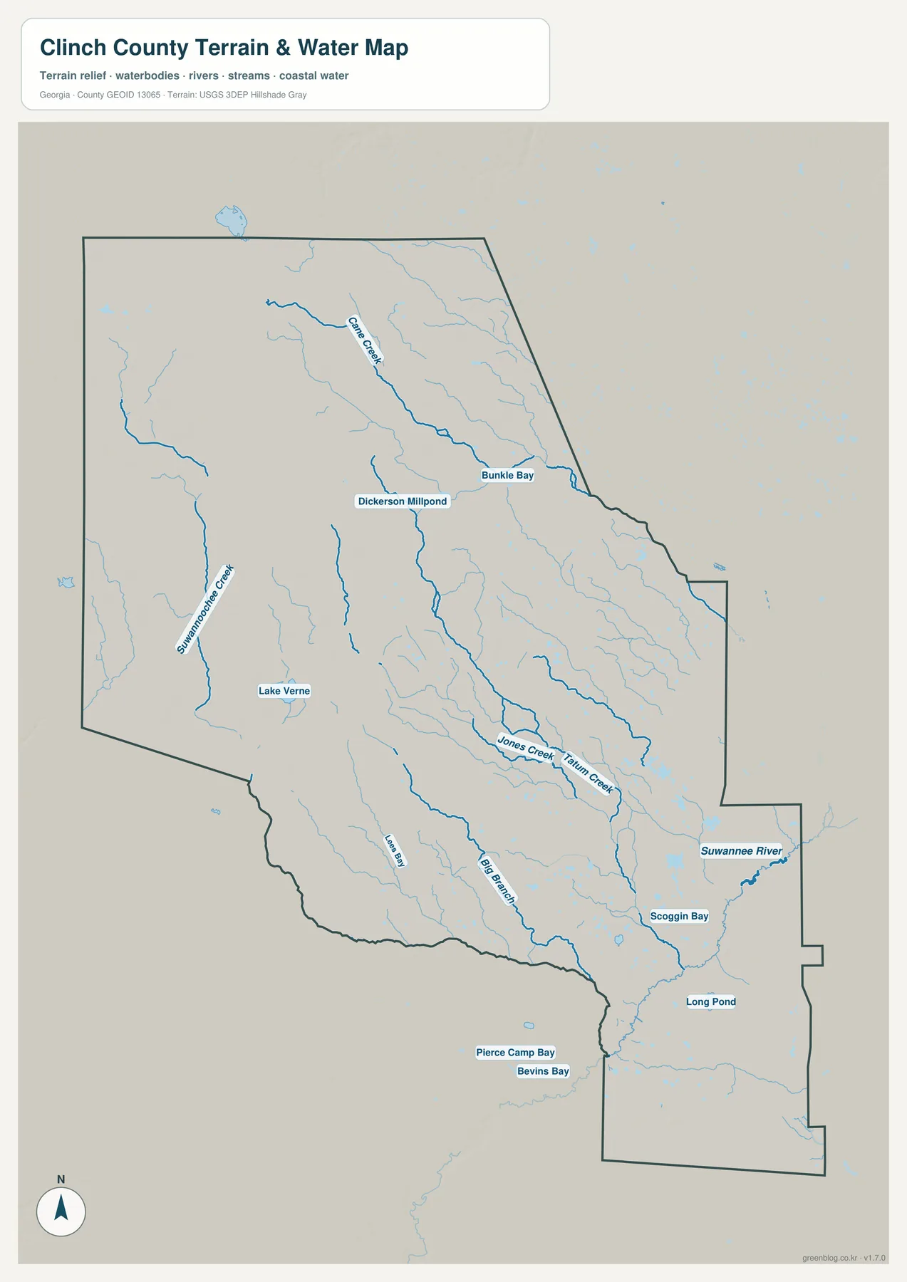
The older verified material places most of the county in the Upper Suwannee watershed, with portions of the west and northwest connected to the Alapaha subbasin. The Okefenokee occupies a broad lowland to the east and southeast, and the Suwannee leaves that wetland system near Fargo before continuing into Florida. Reading the water map beside the county map helps explain why the southern and eastern parts have fewer settlement labels and a much denser network of blue lines and water bodies.
This is a geographic reference map, not a flood-risk or wetland-regulation map. It does not show flood probabilities, legal wetland boundaries, channel depth, navigation status, or current closures. Those questions require the appropriate agency data. Here, the value is simply seeing how many small streams and wet depressions occupy the low Coastal Plain landscape around the larger Suwannee system.
A low-relief landscape from about 29 to 66 meters
The elevation map reports an actual range of about 29 to 66 meters, with a countywide mean near 47 meters. There are no mountain ridges or deep valleys here. Instead, the map shows a gentle transition from somewhat higher ground in the northwest toward lower land across the east and southeast. The Okefenokee-facing portion appears predominantly in the lower green tones.
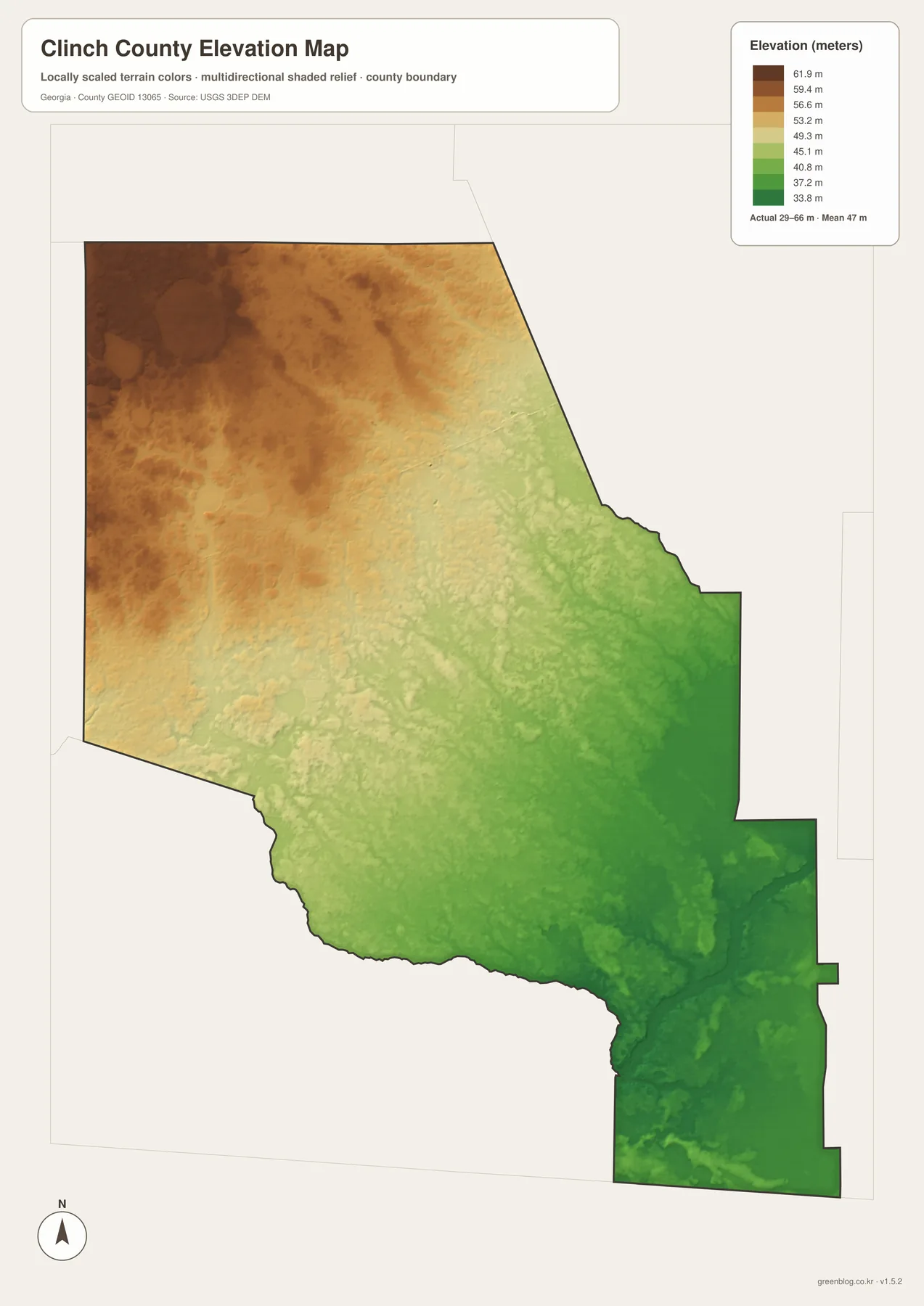
A difference of a few dozen meters may sound small, but on a very flat Coastal Plain it can still influence where water collects and how wet areas connect. The water map and elevation map reinforce one another: the lowest southeastern ground also contains the most intricate network of wetland channels and named water features. The elevation surface is generalized for regional reading, so it should not be used for engineering, drainage design, property-level grading, or survey work.
Okefenokee country and the county’s settlement story
Clinch County was created in 1850 and named for Duncan Lamont Clinch. The material preserved with the original article describes Homerville as a community that grew from a stagecoach stop and later benefited from rail service and the timber and turpentine economy. Argyle began as a railroad station, while Du Pont also developed around transportation and was incorporated under its present name in the nineteenth century. Fargo’s position beside the Suwannee gives it a different geographic character from the three northern communities.
The Okefenokee National Wildlife Refuge, established in 1937, is described in the preserved source material as covering roughly 407,000 acres. The wetland forms the headwaters area for the Suwannee and St. Marys rivers. From the Clinch County side, Fargo is closely associated with western access to the swamp, including the direction toward Stephen C. Foster State Park and State Route 177. Conditions can change because of water levels, wildfire, road work, or refuge operations, so a regional map should be supplemented with current notices before a visit.
That background also explains why a simple settlement map can look unusually empty. Much of the county is not urban land waiting to be filled with labels; it is forest, wetland, blackwater drainage, and sparsely settled rural acreage. The four maps make that contrast visible without requiring a technical GIS interpretation.
Choosing the right map for a specific question
Start with the county map when you need to locate Homerville, follow the major numbered roads, or understand where Clinch County sits relative to nearby counties and Florida. Move to the city map when the main question is settlement spacing; it makes the short Homerville–Argyle and Homerville–Du Pont relationships easy to compare with the much longer gap to Fargo.
Use the water map when discussing the Suwannee River, local creeks, or the wet southeastern part of the county. Add the elevation map when you want to show that the same area is also lower than the northwest. For a classroom handout, report, or presentation, the four A3 JPG files can be used separately so each image supports one clear point instead of forcing every subject onto a single crowded map.
- Regional orientation: use the county map for roads, boundaries, and the location of the four main places.
- Settlement comparison: use the city map for direction and straight-line spacing from Homerville.
- Water geography: use the water map for the Suwannee, creeks, bays, and ponds.
- Terrain context: use the elevation map for the subtle northwest-to-southeast decline.
Frequently Asked Questions
Which places are highlighted on the Clinch County maps?
Homerville, Argyle, Du Pont, and Fargo are the four principal places used on the city-connections map. The broader county map also labels Cogdell and shows surrounding roads and counties. It is not intended to label every community or local road.
Are the 6, 8, and 27 mile city distances driving distances?
No. The map uses straight-line distances from Homerville: roughly 6 miles to Argyle, 8 miles to Du Pont, and 27 miles to Fargo. Actual driving mileage and travel time depend on the road route and current conditions.
Can the elevation map be used for surveying or drainage design?
No. It is a generalized county-scale elevation view designed to show broad terrain differences. Surveying, engineering, property grading, or drainage design requires the relevant high-resolution source data and professional measurements.
Map File Information
Clinch County map files
- Included Files: 4 high-resolution JPG map files shown in this article
- File Type: JPG files in a ZIP archive
- Intended Use: Printing, education, presentations, and map-based projects
Related Maps
Sources and references
The article uses the supplied four-map package and the previously verified county material preserved in the rewrite ZIP. The links below are the same authoritative or established references included with that package for county statistics, roads, local history, the Okefenokee, and Suwannee River conditions.
- U.S. Census Bureau: Clinch County QuickFacts
- Georgia DOT: Clinch County general highway map
- U.S. Fish and Wildlife Service: Okefenokee National Wildlife Refuge
- USGS: Suwannee River above Fargo monitoring location
- New Georgia Encyclopedia: Clinch County history
Green Map creates custom-edited map images using open geographic data sources such as geoBoundaries, Natural Earth, OpenStreetMap, and government open data. These maps are edited visual materials, not raw data files, and are provided for education, documents, presentations, and graphic reference.