The Kemper County Map is most useful when it is read through a few clear reference points rather than as a dense city map. De Kalb and Scooba provide the main place names, roads define movement across a large rural county, and the water and elevation maps reveal a landscape cut by many small creek valleys. This page explains those features from the supplied maps and provides a download of the high-resolution A3 JPG county, city, water, and elevation files for printing or editing.
Table of Contents
Start with De Kalb and Scooba
Kemper County lies along Mississippi’s eastern side at the Alabama state line. The general map gives De Kalb and Scooba enough visual weight to serve as the easiest orientation points. De Kalb sits farther inland, while Scooba is positioned toward the northeastern side of the county. Reading the two together makes the county’s large size easier to understand because the labeled communities are separated by broad areas of roads, wooded ridges, and creek valleys rather than a continuous urban corridor.
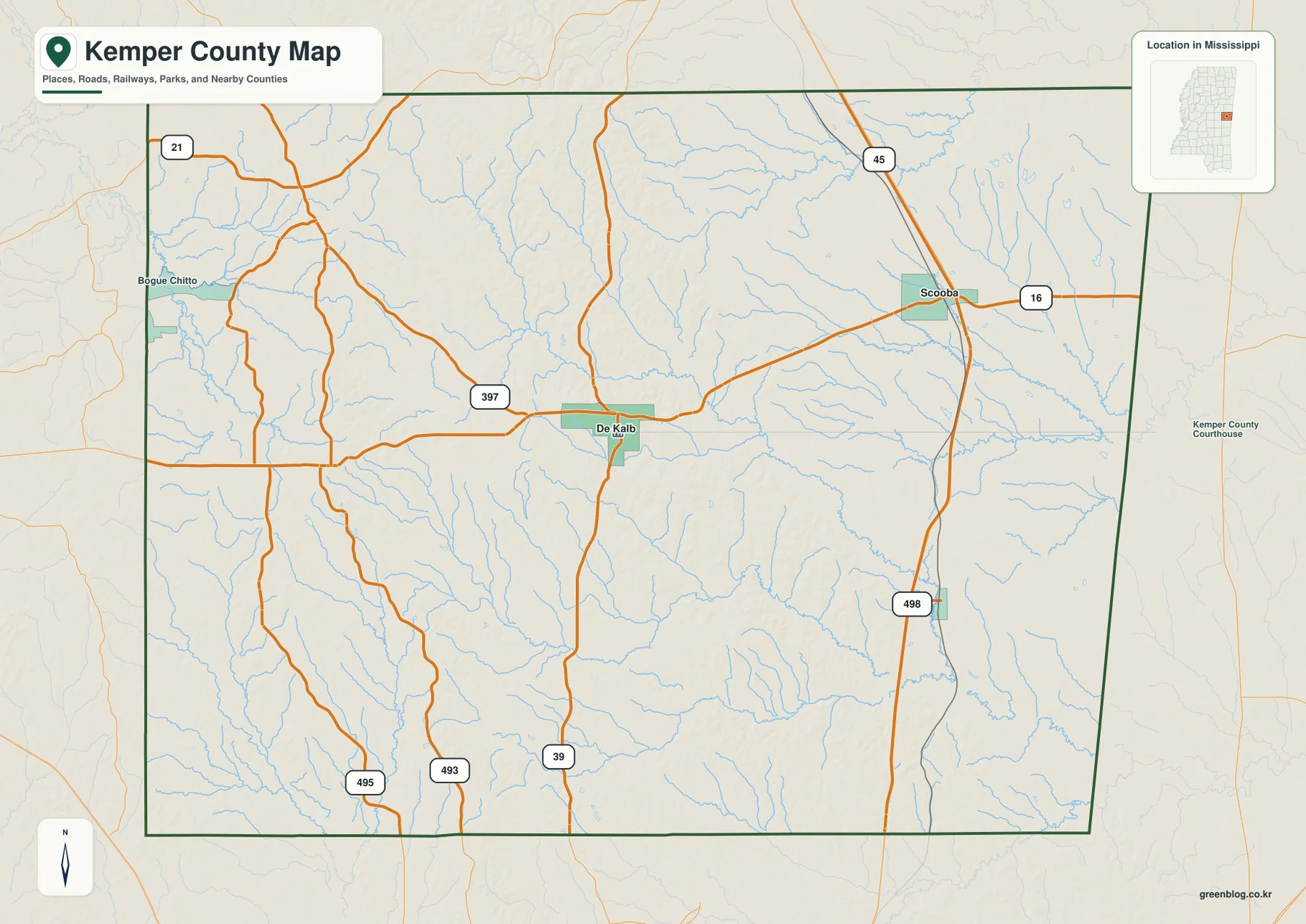
Scooba is especially useful for reading the highway system because US 45 runs north-south through that part of the map and MS 16 crosses east-west. De Kalb lies to the west along the central road network, with routes continuing south toward the MS 39 area. Other numbered roads appear around the county edges, including MS 21 in the northwest and several routes across the southern half. The result is a map where road numbers are often more helpful than town names when a reader needs to describe a direction across the county.
| Reference | Value or map detail |
|---|---|
| County seat | De Kalb |
| Major places on the city map | De Kalb and Scooba |
| 2020 census population | 8,988 |
| July 2025 population estimate | 8,600 |
| 2025 Gazetteer area | 766.182 sq mi land; 0.843 sq mi water |
| 2020 population per 2025 land area | about 11.7 residents per sq mi |
| Elevation shown on the supplied map | about 41–204 m; mean 104 m |
The population and area figures come from different reference dates, so they are best treated as separate context rather than as one same-year statistical snapshot. What matters for the map is the scale: more than 766 square miles of land are represented, while the city index highlights only two major places. That contrast helps explain why the county map contains so much visible road, creek, and terrain information between named settlements.
A sparse city pattern makes the road network stand out
The city map is unusually simple. Its ranked index shows De Kalb at 791 and Scooba at 718, with no long list of additional major cities competing for attention. Because of that simplicity, the map works well for comparing the two communities and the space between them. It also makes the surrounding county labels and the broad rural portions of Kemper County easier to notice than they would be on a dense metropolitan map.
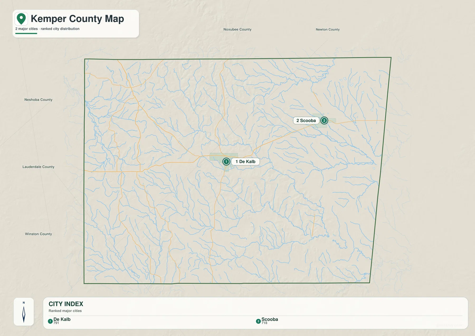
De Kalb provides the better central reference, while Scooba helps explain the eastern highway side of the county. Moving east from De Kalb brings the reader toward Scooba and the US 45 corridor. From Scooba, the north-south highway is easy to trace toward the county limits, while MS 16 gives an east-west reference. This arrangement is practical for someone trying to explain where a rural road, creek, or property area lies without relying on a large number of nearby cities.
The straight eastern edge of the county also gives the map a strong visual reference because it is the Mississippi-Alabama state line. Scooba lies much closer to this side than De Kalb. When the map is used in a report, classroom handout, or travel-planning note, identifying the state line first and then locating Scooba and De Kalb is often the quickest way to make the county understandable to someone who has never seen it before.
Creek valleys fill the spaces between the roads
The water map changes the impression of Kemper County. Areas that look relatively open on the general road map are crossed by a dense network of small streams. Sucarnoochee Creek is one of the clearest labeled features, while Wahulak Creek appears across the northern part of the map. Big Scooba Creek helps identify the eastern side near Scooba, and Blackwater Creek is labeled farther south. Bogue Chitto Creek is visible toward the western side, adding another reference for the county’s many drainage valleys.
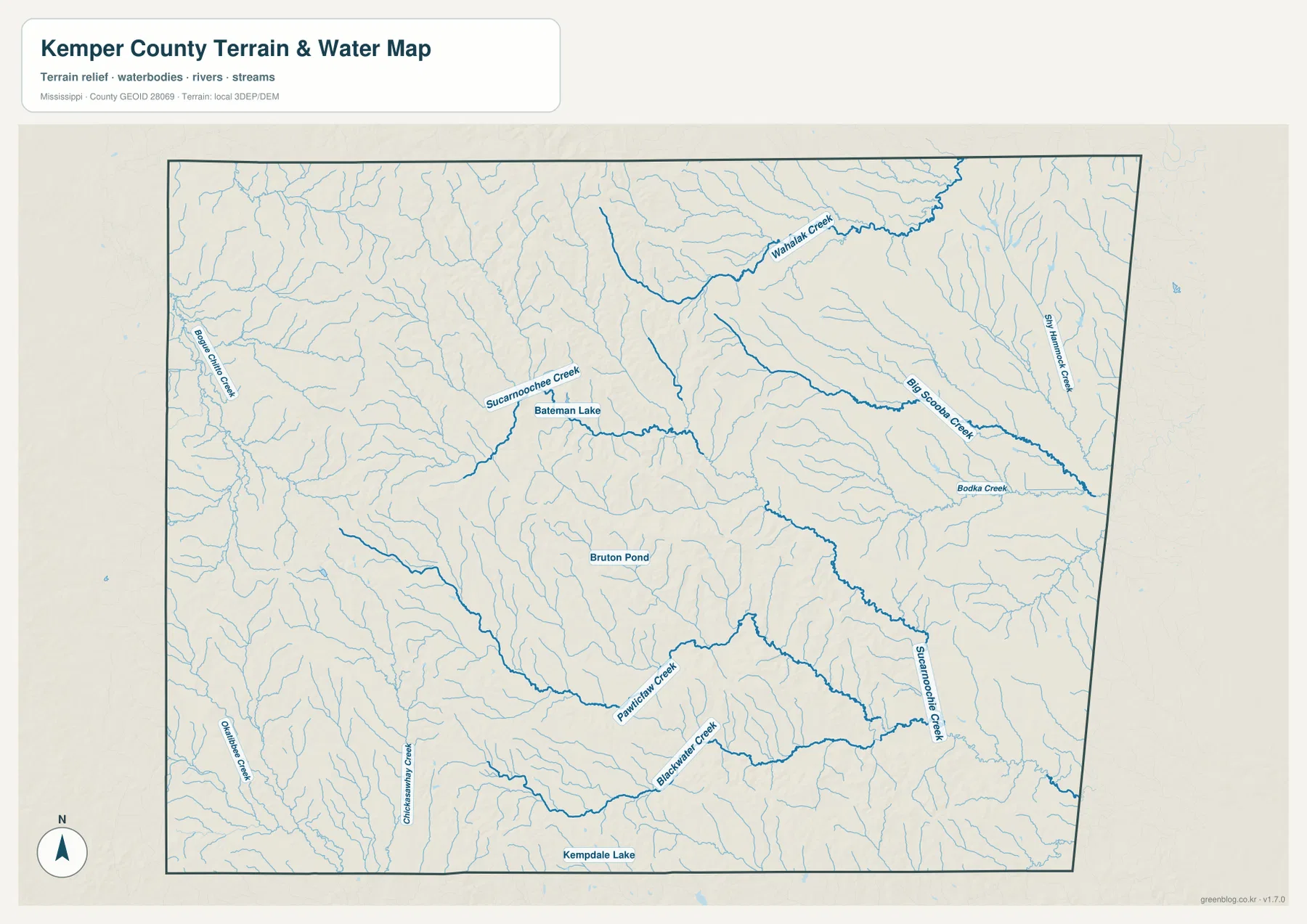
Several small named water bodies provide additional anchors. Bateman Lake is shown near the Sucarnoochee Creek area, Bruton Pond appears closer to the middle of the county, and Kempdale Lake is marked near the southern edge. None dominates the county in the way a large reservoir might, but together they reinforce how finely divided the landscape is. Numerous unnamed tributaries branch away from the labeled creeks, so a location that appears close on a straight-line road map may sit across several small valleys.
This version is useful when the purpose is more specific than simply finding De Kalb or Scooba. A presentation about local water, a land-description document, or a geographic lesson can use the labeled creeks to explain where lower ground occurs. Comparing the water map with the elevation map is especially helpful because many of the stream lines correspond with narrow low areas between ridges.
From western uplands to lower eastern terrain
The supplied elevation map reports an actual range of about 41 to 204 meters, with a mean of 104 meters. The western side contains much more brown and tan shading, indicating higher ground, while broad areas in the east are green and lower. The center is not a simple slope. Narrow ridges and valleys repeat across the county, creating a textured transition between the higher west and the lower east.
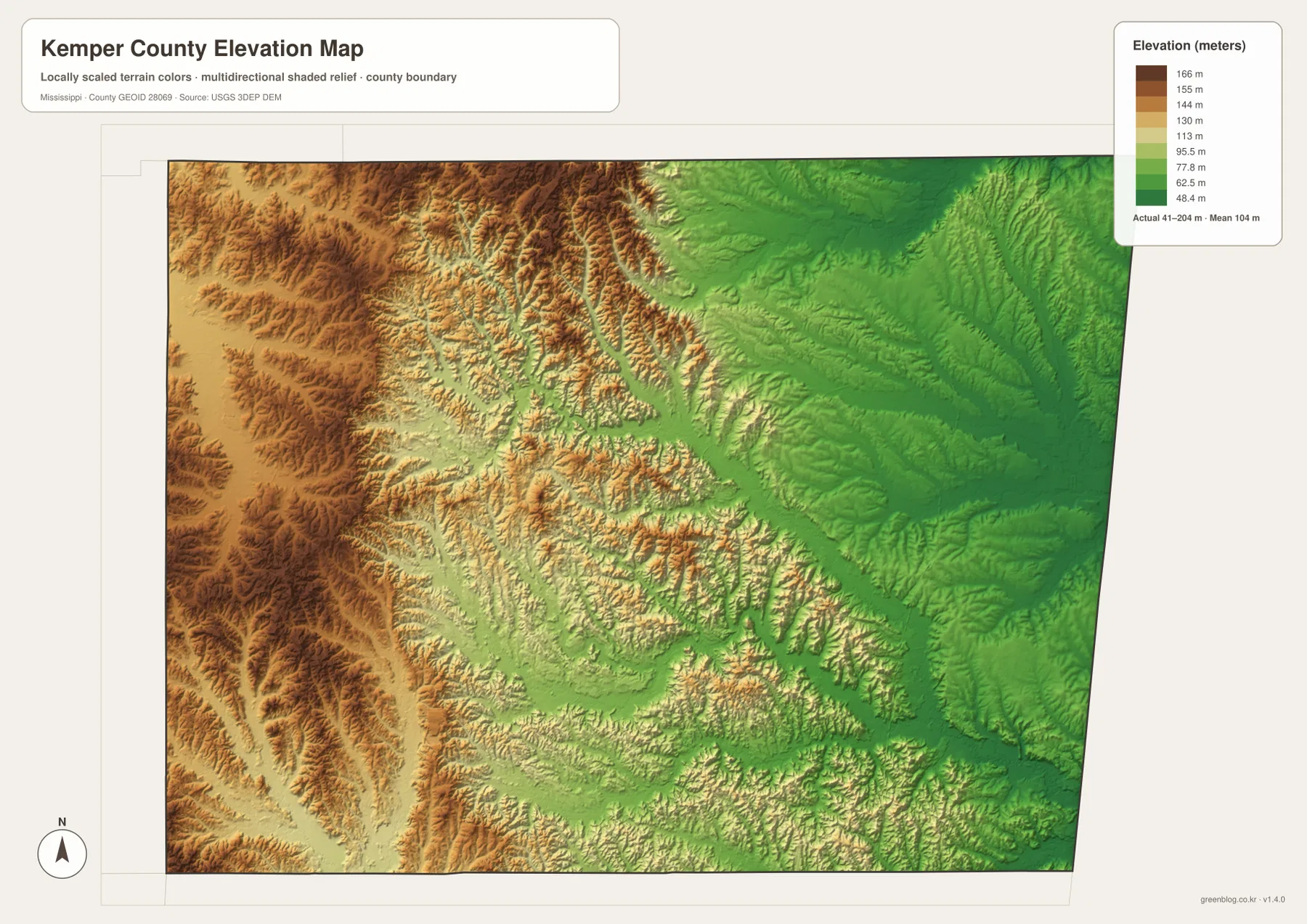
The color difference becomes more meaningful when the creek map is kept nearby. Many streams occupy the lower grooves between ridges, while the higher western terrain is broken by repeated valleys. The eastern side is generally lower, but it still contains local ridges and drainage cuts rather than one flat plain. This is why the elevation version is useful for broad terrain comparison even when the exact height of a specific parcel must be checked against more detailed elevation data.
For a county map page, the most important message is not the single highest or lowest point. The practical value is seeing how much relief exists across a county that may look fairly uniform on a simple boundary map. A 41–204 m range is enough to make creek valleys and upland roads visually distinct, and that distinction helps explain why the water network is so intricate.
Choose the version that matches the job
The general county map is the best starting point when roads, De Kalb, Scooba, and the state boundary are the main questions. The city version is cleaner when the goal is simply to show the two principal places without extra detail. The water map is better for creek names and small lakes, while the elevation map is the clearest choice for comparing the higher west with the lower eastern side. Using one map for one clear purpose usually produces a more readable handout or presentation than stacking every layer into a single image.
The WebP images on this page are optimized for online viewing. For printing, classroom materials, document design, or video editing, the downloadable archive contains the matching county, city, water, and elevation maps as high-resolution A3 JPG files. The archive makes it possible to keep the clean web previews on the page while using larger source images for offline work.
Frequently Asked Questions
What is the county seat of Kemper County?
De Kalb is listed as the county seat in the supplied material. On the maps it also works as the stronger central reference point, while Scooba provides the clearest highway reference on the eastern side.
Why is Scooba useful for reading the road map?
Scooba is positioned where the map clearly shows the US 45 north-south corridor and MS 16 running east-west. That makes it a convenient reference for describing travel toward the northern or southern county limits and for locating the Alabama side of the county.
Is Kemper County mostly flat?
No. The supplied elevation map shows an actual range of roughly 41–204 meters with a 104-meter mean. Higher terrain is especially noticeable in the west, while lower green areas are more extensive in the east, with many creek valleys cutting through the county.
Map File Information
The ZIP contains the Kemper County general, city, water, and elevation maps as high-resolution A3 JPG files.
- Included Files: County map, city map, water map, elevation map
Related Maps
- Abbeville, Headland, and Lake Eufaula on the Henry County Alabama Map
- Athens to Wheeler Reservoir on the Limestone County Alabama Map
- Autauga County Alabama Land Cover Map
Sources and References
- U.S. Census Bureau QuickFacts for Kemper County – population reference
- U.S. Census Bureau Gazetteer Files – land and water area reference
- Mississippi Department of Transportation official highway map – road-number reference
- USGS National Hydrography – stream and water reference
- USGS 3D Elevation Program – elevation reference
Green Map creates custom-edited map images using open geographic data sources such as geoBoundaries, Natural Earth, OpenStreetMap, and government open data. These maps are edited visual materials, not raw data files, and are provided for education, documents, presentations, and graphic reference.